ArcGIS+Desktop使用手册
ARCGIS9.3.1安装手册
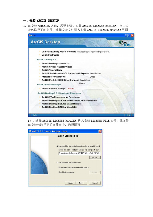
一、安装ARCGIS DESKTOP1.在安装ARCGIS之前,需要安装先安装ARCGIS LICENSE MANAGER,点击安装包路径下的文件,选择安装文件进入安装ARCGIS LICENSE MANAGER界面1)、选择ARCGIS LICENSE MANAGER 进入安装LICENSE FILE文件,此文件在安装包路径下的文件夹中,选择即可2)、然后一直点击“NEXT”按钮到如下界面,选择不要重启计算机,后退出3)、在安装包路径下arcgis\ArcGis Desktop 9.3.1软件\Crack.Only-TBE\Crack.Only-TBE\license_server_crack文件下的Arc_Info9.lic文件4)、把第一行的“SERVER yl ESRI_SENTINEL_KEY=37102011 27001”中的 yl 改为本机的计算机名,保存。
如图所示;5)、查看本机计算机名的方法:右键点击桌面“我的电脑”选择“属性”出现以下窗口6)、点击“计算机名”窗口中“完整的计算机名称”就是本机的计算机名(每台电脑都不相同的,最后面的点不要复制)7)、把arcgis\ArcGis Desktop 9.3.1软件\Crack.Only-TBE\Crack.Only-TBE\license_server_crack文件下5文件全部复制后,然后到License Manager安装目录下(一般为c:\programfiles\esri\license\arcgis9x),覆盖该目录下相对应文件;8)、打开License Manager Tools(开始→程序→ArcGIS→License Manager(9.x)→License Manage r Tools);A、点“Configuration using Services”,选择“ArgGIS license server”,B、然后切换到“Configure Services”,设置“Path to the license file”为“c:\program files\esri\license\arcgis9x\Arc_Info9.lic”,点“Save Service”;出现以下窗口再点击“是”C、再切换到“Start/Stop/Reread ”,试试三个按钮,(如下图所示)保证它们都正常工作。
Esri ArcGIS Desktop 10.5功能矩阵说明书
May 2017ArcGIS® Desktop10.5: ArcMap™FunctionalityMatrixCopyright © 2017 EsriAll rights reserved.Printed in the United States of America.The information contained in this document is the exclusive property of Esri. This work is protected under United States copyright law and other international copyright treaties and conventions. No part of this work may be reproduced or transmitted in any form or by any means, electronic or mechanical, including photocopying and recording, or by any information storage or retrieval system, except as expressly permitted in writing by Esri. All requests should be sent to Attention: Contracts and Legal Services Manager, Esri, 380 New York Street, Redlands, CA 92373-8100 USA.The information contained in this document is subject to change without notice.Esri, the Esri globe logo, ArcGIS, ArcMap, ArcPress, ArcScan, ArcToolbox, ArcPy, ArcView, ArcInfo, ArcSDE, ArcObjects, ArcCatalog, 3D Analyst, SDE, PC ARC/INFO, ArcIMS, ModelBuilder, StreetMap, ArcPad, GeoEnrichment, The Science of Where, ,*************************,servicemarks,orregisteredmarksofEsriintheUnitedStates,theEuropeanCommunity, or certain other jurisdictions. Other companies and products or services mentioned herein may be trademarks, service marks, or registered marks of their respective mark owners.ArcGIS Desktop 10.5: ArcMap Functionality Matrix Mapping (7)M ap Interaction (7)M ap Navigation (7)Q ueries (7)Tables (8)G raphs (8)G raph Types (8)R outing Using ArcGIS Online or Network Datasets (StreetMap USA) (8)M ap Display (9)G eneral Mapping (9)T abular Data (9)V ector Data Display (9)T hematic Vector Data Classifications (9)S ymbology (10)E levation Surface Display (10)R aster Data Display (10)R aster Display: Gradual Color Ramp Data-Stretching Algorithms (10)Raster Panchromatic Sharpening (11)Raster Display Statistics (11)R aster Display Resample Methods (11)R aster Display Classification Methods (11)R aster Catalog Footprint Display (11)R aster Tools (11)T ime Animation and Temporal Data (11)P age Layout and Printing (11)M ap Elements (11)E xport Formats (12)P rint with the Following Print Drivers (12)P ublishing and Sharing Maps and Data (12)C reating High-Performance Dynamic Maps (12)S haring Maps, Layers, and Data (12)Publishing and Sharing Analysis (13)Sharing Geoprocessing (13)Sharing Geocoding (13)Automating Map Workflows (13)Using the ArcPy Mapping Module (13)M ap Text (13)L abels (13)A nnotation (13)A nnotation Editing (13)A nnotation and Dimensions Management (14)Advanced Labeling (14)A dvanced Label Placement Rule Set (14)A dvanced Cartography (14)C artographic Editing Tools (14)P oint Geometric Effects (15)L ine Geometric Effects (15)P olygon Geometric Effects (15)I nteractive Symbol Editing (16)G eoprocessing Graphic Quality (16)G eoprocessing Masking Tools (16)G eoprocessing Representation Management (16)G eoprocessing Symbolization Refinement (16)A ddress Matching (17)G eocoding Tools (17)A rcGIS Online Locator (17)G eoprocessing (17)D ata Support and Interoperability (17)R aster Data Support (17)D irect Read of Raster Data (17)D irect Read and Write of Raster Data (19)G eodatabase Raster Management (20)D ocument and Data Support (20)M ap and Symbology Files (20)D irect Read of Vector and Raster Data (20)D irect Editing of Vector Data (21)D irect Read of Other Data (21)C oordinate Systems (21)C AD Support (21)C AD File Support (21)D irect Read of CAD Data (21)E diting with CAD Data (21)C oordinate Systems (22)G eoprocessing—See Geoprocessing Conversion (22)A pplication Framework (22)A pplication Customization (22)A pplication Look and Feel (22)C ustomization (22)D ata Automation (22)D ata Editing (22)G eneral Editing (22)S napping Types (23)S napping to Topology Elements (23)S napping Tolerance (23)G eometry Construction Options (23)G eometry Creation Tools (23)F eature Manipulation Tasks (24)F eature Editing Tools (24)A ttribute Editing (24)M ultipart Features (Point, Line, and Polygon) (24)M ap Navigation While Editing (24)V ector Data Transformations (25)G eneralization (25)C oordinate Geometry (25)P arcel Editing (25)Raster Editing and Vectorization (25)V ectorize All Raster Formats Supported in ArcGIS (25)A rcGIS Integration (25)R aster Snapping Geometry (26)R aster Snapping Environment (26)V ectorization Tracing (26)A utomatic Vectorization (26)V ectorization Parameters (26)V ectorization Preview (26)R aster Cell Selection (26)R aster Cleanup Environment (26)R aster Cleanup Painting Tools (26)S upport Tools (26)M obile (27)G PS Support (27)T ablet PC (27)A rcGIS Mobile Support (27)M ultiuser Geodatabase Editing (27)G eneral Editing (27)A dministration Geoprocessing (27)V ersioning Geoprocessing (27)S hort Transaction Editing (28)M ultiuser Geodatabase Archiving (28)D isplay and Query (28)M anage (28)D istributed Geodatabases (28)M anage Replicas (28)D isconnected Editing Geoprocessing (28)D istributed Geodatabases Geoprocessing (28)Spatial Referencing Image Data (Georeferencing) (29)T ools (29)T ransformation Methods (29)S ave Spatial Reference Information (29)D ata Management and Validation (29)D ata Management (29)G eneral (29)S earch for Maps, Data, and Tools (29)M anage Coverage Data (29)Geodatabase and Database Administration (30)G eodatabase XML File Import/Export (30)A ttribute Validation (30)S ubtypes Geoprocessing (30)D omains Geoprocessing (30)C reate and Edit Relationships for Features (30)G eodatabase Relationship Behavior (30)R elationship Class Geoprocessing (31)T opology (31)M ap Display (31)E diting (31)G eodatabase Topology Rule Violation Fix Operations (31)G eodatabase Topology Management (31)G eodatabase Topology Rules (32)G eoprocessing (32)N etworks (33)U tility (Geometric) Network Analysis (33)D ata Management (33)G eometric Network Connectivity Rules (33)G eometric Network Editing (33)L inear Referencing (Routes) (33)D isplay (33)E diting (33)G eoprocessing (34)M etadata (34)G eneral (34)M anaging Metadata Using a Variety of Styles (34)G eoprocessing (34)D ata Manipulation and Analysis (34)C overage Geoprocessing (34)A pplication Framework (34)A nalysis (35)C onversion (35)A ggregation (35)C omposite Features (35)G eneralization (35)T able Management (35)P rojections (36)T opology (36)G eneral (36)G eoprocessing (36)E nvironment (36)S upported Scripting Environments (36)G eneral Data Management (36)D ata Comparison (37)Archiving (37)Attachments (37)T able Management (37)E diting (37)Conflation (37)F ield Management (38)F eature Class Management (38)F eature Management (38)F ile Geodatabase (39)G eneralization (39)P rojections and Transformations (39)V ector Data Projection (39)R aster Management (39)R aster Mosaics (40)R aster Conversion (41)R aster Transformation/Projection (41)LAS Datasets (41)C onversion (41)L ayers and Table Views (42)P ackaging (42)Photos (43)P arcel Fabric Tools (43)C ore Analysis (43)S pace-Time Pattern Mining (43)S patial Statistics Tools—Analyzing Patterns (43)S patial Statistics Tools—Mapping Clusters (43)S patial Statistics Tools—Measuring Geographic Distributions (44)S patial Statistics Tools—Modeling Spatial Relationships (44)S patial Statistics Tools—Rendering (44)S patial Statistics Tools—Utilities (44)M ultidimensional Tools (44)W orkspace Management (44)Geodatabase Administration (45)Geometric Networks (45)T able Joins (45)D ata Indexing (45)A rcGIS Server Management (46)D ata (46)A rcGIS Online Services (46)Basemap Services (via Add Basemap Menu) (46)ArcGIS Online Living Atlas of the World (46)ArcGIS Online Tasks (4746)Portal for ArcGIS (47)Data and Maps for ArcGIS (47)E sri Data and Maps (Also Available in the ArcGIS Online Living Atlas of the World) (47)StreetMap Premium for ArcGIS (47)ArcGIS® Desktop 10.5 allows you to author geographic information to examine relationships; analyze your data; test predictions; and, ultimately, make better decisions. It is available in three license levels—Basic, Standard, and Advanced. These license levels have the same integrated applications, user interfaces, and development environment.Mapping1Requires ArcGIS Server2Geoprocessing Results3Feature Service or Cached Map Tile Service4ArcGIS Online, Portal for ArcGIS, or Cloud-Hosted ArcGIS Server Instance5Share locally or in an ArcGIS Online or Portal for ArcGIS instance.6The advanced labeling functionality is available as a setting on the Data View tab in the ArcMap TM Options dialog box.D ata Support and Interoperability7Oracle Spatial GeoRaster requires the data to be registered with the geodatabase or created using ArcGIS Desktop.8These formats can be written to through programming with the ArcObjects™ API.9Basic can only create geodatabase rasters or raster attribute tables in personal or file geodatabases. Standard and Advanced can create and manage geodatabase rasters in personal, file, and multiuser geodatabases.10These features require the installation of the ArcGIS Data Interoperability extension, but a license for this extension is not required.Application FrameworkD ata Automation11The vectorization functionality is available through ArcScan™ for ArcGIS in ArcMap, which can be enabled from the Customize > Extensions menu.12Spatial referencing of rasters stored in an ArcSDE workspace requires the Standard or Advanced license level.D ata Management and Validation13Only available with simple features in map-based topologiesD ata Manipulation and Analysis14Coverage geoprocessing tools require the installation of ArcInfo Workstation 10.15Also available to Basic or Standard license level users who have the ArcGIS 3D Analyst™ or ArcGIS Spatial Analyst extension 16Also available to Basic license level users who have the ArcGIS 3D Analyst or ArcGIS Spatial Analyst extension17Basic license level users cannot create photo attachments.18Requires the ArcGIS Network Analyst extension19Also available to Basic or Standard license level users who have the ArcGIS Spatial Analyst or ArcGIS Geostatistical Analyst extensionD ata20Requires a license key from Microsoft or a connection to an ArcGIS Online organizational account with a registered key 21Requires Portal for ArcGISFor more information, visit /desktop.。
ArcGIS Desktop 轻松入门教程
第1页
2 ArcGIS简介
ArcGIS 轻松入门教程
——ArcGIS Desktop
2.1 什么是GIS
物质世界中的任何地物都被牢牢地打上了时空的烙印。人们的生产和生活中 80% 以 上 的 信 息 和 地 理 空 间 位 置 有 关 。 地 理 信 息 系 统 ( Geographic Information System, 简称 GIS)作为获取、处理、管理和分析地理空间数据的 重要工具、技术和学科,近年来得到了广泛关注和迅猛发展。
ESRI 中国(北京)有限公司 2008 年 3 月
目录
ArcGIS 轻松入门教程
——ArcGIS Desktop
1 引言 ...................................................................................................1
ArcGIS 轻松入门教程
——ArcGIS Desktop
版权声明
ArcGIS 轻松入门教程
——ArcGIS Desktop
美国 ESRI 公司和 ESRI 中国(北京)有限公司拥有本手册所有资源的版权。 在本手册中刊载的所有图片和文字信息除特别标明之外,版权归 ESRI 公司和 ESRI 中国(北京)有限公司。本手册中的所有内容和图片受《中华人民共和国 著作权法》及相关法律法规和中国加入的所有知识产权方面的国际条约的保护。 任何单位和个人未经 ESRI 中国(北京)有限公司的允许,不得以任何方式、任 何文字或图片作全部和局部变更、发行、复制、转载、引用,否则将视作侵权, ESRI 公司和 ESRI 中国(北京)有限公司公司保留依法追究其责任的权利。本手 册之声明以及其修改权、更新权及最终解释权均属 ESRI 公司和 ESRI 中国(北京) 有限公司。
ArcGIS Desktop 10.6快速入门指南说明书
Quick Start GuidesTable of ContentsCore products and componentsArcGIS for Desktop . . . . . . . . . . . . . . . . . . . . . . . . . . . . . . . . . . . . . . . . . . . 3 ArcGIS Enterprise . . . . . . . . . . . . . . . . . . . . . . . . . . . . . . . . . . . . . . . . . . . . 4 ArcGIS Engine Developer Kit and ArcGIS Engine . . . . . . . . . . . . . . . . . . . . . . . . . . . . . . . . 6 ArcGIS License Manager . . . . . . . . . . . . . . . . . . . . . . . . . . . . . . . . . . . . . . . . . 8Getting started•ArcGIS Desktop includes many components. See What's included for a list of components.•Review the ArcGIS system requirements for the component.•Administrative privileges are required for installation.•Microsoft .NET Framework 4.5 or later is required.•Download and install the component. If upgrading, review Upgrading to ArcGIS 10.6.•Obtain your software authorization numbers and authorize the software. If using a Concurrent Use license, you will need ArcGIS License Manager 10.6, which can be used for all ArcGIS 10.x Concurrent Use licenses. See the ArcGIS License Manager quick start guide and the License Manager reference guide for more information.•See ArcGIS Desktop for access to additional resources, such as documentation and support.What's includedArcGIS Desktop10.6 includes the following components:•ArcGIS Desktop—Installation for Basic, Standard, and Advanced editions of ArcGIS Desktop, and optional ArcGIS extension products.•ArcGIS Desktop Background Geoprocessing (64 bit)—Installation for background geoprocessing in 64 bit.•ArcGIS License Manager (Windows and Linux)—This version is required to run ArcGIS Desktop10.6 and ArcGIS Engine 10.6 with Concurrent Use licensing. It also supports all other ArcGIS 10.x Concurrent Use releases.•ArcReader—Desktop mapping application that allows users to view, explore, and print maps and globes.•ArcGIS Tutorial Data for Desktop—Data used with ArcGIS Desktop tutorials.•ArcGIS Coordinate Systems Data—Contains the data files required for the GEOCON transformation method and vertical transformation files for the United States (VERTCON and GEOID12B) and the world (EGM2008).•DBMS Support Files—Client libraries and databases to be used to directly connect to geodatabases.The following developer tools are available:•ArcObjects SDK for Microsoft .NET Framework—Documentation and sample code for Microsoft .NET Framework developers customizing and extending ArcGIS Engine,ArcGIS Desktop, and ArcGIS Server.•ArcObjects SDK for Java—Documentation, tools, and sample code for Java Platform developers customizing and extending ArcGIS Engine,ArcGIS Desktop, and ArcGIS Server.Upgrading to ArcGIS 10.6•The ArcGIS 10.6 setup package is designed to detect and upgrade an existing installation of the same ArcGIS product. The settings for the installation location, license manager (for Concurrent Use), or authorization information (for Single Use) areretained in the upgrade. See the installation guide for more information on installation upgrades and new installations.•Existing ArcGIS 10.1–10.5.1 authorization numbers will work with ArcGIS 10.6.•ArcGIS 10.6 for Single Use—If ArcGIS 10.6 will be installed on a machine that is different from where an earlier ArcGIS 10.x product is currently installed and you want to use the existing ArcGIS 10.1–10.5.1 authorization number for ArcGIS 10.6, the earlier version of an ArcGIS 10.x product must first be deauthorized before authorizing ArcGIS 10.6.Obtaining software authorization numbersIf needed, your account's primary maintenance contact can obtain authorization numbers from My Esri. After signing in with your Esri Account, click My Organizations>Licensing>View Authorizations. Click a product name to obtain its authorization number.The license version on authorizations eligible for use with ArcGIS 10.6 will display as 10.1–10.6 under View Authorizations. For those outside the United States, contact your local distributor for information about your authorization numbers.Getting startedArcGIS Enterprise represents the evolution of Esri's GIS server technology into a complete GIS platform in your own infrastructure, supporting enterprises of any size. ArcGIS Enterprise provides a full Web GIS experience integrated with ArcGIS Online and ArcGIS Desktop. See the following prerequisites to get started:•ArcGIS Enterprise includes many components. See What's included for a list of components.•Review the system requirements for each component.•Administrative privileges are required for installation.•On Windows, Microsoft .NET Framework 4.5 is required for installing the ArcGIS Server .NET Extension Support feature. ArcGIS Web Adaptor for IIS also requires Microsoft .NET Framework 4.5. This version of Microsoft .NET Framework can be downloaded from Microsoft.•Download and install the component. If you're upgrading, review Upgrading to ArcGIS 10.6. For help, see the corresponding installation guide available with the download.•Obtain your software authorization numbers and authorize the software. If your Portal for ArcGIS organization will use a premium app, such as ArcGIS Pro or Drone2Map for ArcGIS, you will also need ArcGIS License Manager 10.6 to configure your premium app licenses to specify which members can use the software. See the Portal for ArcGIS Administrator Guide,License Manager Reference Guide, and the ArcGIS License Manager system requirements for more information.Visit ArcGIS Enterprise for access to additional resources such as documentation and support.What's includedArcGIS Enterprise 10.6 includes the following components:•ArcGIS Enterprise Builder—Provides a simple installation and configuration experience for a base ArcGIS Enterprise deployment on a single machine.•ArcGIS Server—Makes your geographic information available to others in your organization and, optionally, anyone with an Internet connection. It can be licensed in a variety of roles, depending on the capabilities you want to enable for your deployment.See ArcGIS Enterprise licensing for a complete listing of server licensing roles.•Portal for ArcGIS—Allows you to share maps, apps, and other geographic information with other people in your organization through a website.•ArcGIS Data Store—An application you can use to set up different types of data stores used by a Portal for ArcGIS hosting server.•ArcGIS Web Adaptor—Allows ArcGIS Server to integrate with your existing web server. It is compatible with IIS and Java EE servers such as WebSphere and WebLogic.ArcGIS GeoEvent Server—Enables real-time event-based data streams to be integrated as data sources in your enterprise GIS. Requires an ArcGIS GeoEvent Server license role.•ArcGIS License Manager (Windows and Linux)—This version is required to configure ArcGIS Pro or Drone2Map for ArcGIS licenses with your Portal for ArcGIS 10.6 organization.•ArcGIS Coordinate Systems Data— Contains the data files required for the GEOCON transformation method and vertical transformation files for the United States (VERTCON and GEOID12B) and the world (EGM2008).•DBMS Support Files—Client libraries and databases used to directly connect to geodatabases.The following developer tools are available:•ArcObjects SDK for the Microsoft .NET Framework—Documentation and sample code for Microsoft .NET Framework developers customizing and extending ArcGIS Engine, ArcGIS Desktop, and ArcGIS Server.•ArcObjects SDK for Java—Documentation, tools, and sample code for Java platform developers customizing and extending ArcGIS Engine, ArcGIS Desktop, and ArcGIS Server.Upgrading to ArcGIS 10.6•The ArcGIS 10.6 setup package is designed to detect and upgrade an existing installation of the same ArcGIS product. The settings for the installation location are retained in the upgrade. However, you will need to obtain a 10.6 software authorization number and reauthorize for use in 10.6. See the installation guide for more information on installation upgrades and newinstallations.•Existing ArcGIS Enterprise 10.5 - 10.5.1 authorization numbers will work with ArcGIS Enterprise 10.6 Prerelease but will not work for the final release of ArcGIS Enterprise 10.6.Obtaining software authorization numbersIf needed, your account's primary maintenance contact can obtain authorization numbers from My Esri. After signing in with your Esri Account, click My Organizations > Licensing > View Authorizations. Click a product name to obtain its authorization number.The license version on ArcGIS Enterprise authorizations eligible for use with ArcGIS 10.6 will display as 10.6 under View Authorizations. Customers in the United States need to contact Esri Telesales to order additional Named User License of Portal for ArcGIS. For those outside the United States, contact your local distributor for information about your authorization numbers.ArcGIS Engine Developer Kit 10.6 and ArcGIS Engine 10.6 quick start guideGetting started•ArcGIS Engine includes many components. See What's included for a list of ArcGIS Engine components.•Review the ArcGIS system requirements for the component.•Administrative privileges are required for installation.•On Windows, the Microsoft .NET Framework 4.5 or later is required for installing ArcGIS Engine.•Download and install the component. If upgrading, review Upgrading to ArcGIS 10.6.•Obtain your software authorization numbers and authorize the software. If using a Concurrent Use license, you will need ArcGIS License Manager 10.6, which can be used for all ArcGIS 10.x Concurrent Use licenses. See the ArcGIS License Manager quick start guide and the License Manager reference guide for more information.•See ArcGIS Desktop for access to additional resources, such as documentation and support.What's includedArcGIS Engine 10.6 includes the following components:•ArcGIS Engine—Component that supports the creation of GIS and mapping applications.•ArcGIS Engine Background Geoprocessing (64 bit)—Installation for background geoprocessing in 64 bit.•ArcGIS License Manager (Windows and Linux)—This version is required to run ArcGIS Desktop and ArcGIS Engine 10.6 with Concurrent Use licensing. It also supports all other ArcGIS 10.x Concurrent Use releases.•ArcGIS Coordinate Systems Data—Contains the data files required for the GEOCON transformation method and vertical transformation files for the United States (VERTCON and GEOID12B) and the world (EGM2008).•DBMS Support Files—Client libraries and databases to be used to directly connect to geodatabases.Developer tools are available with ArcGIS Engine Developer Kit 10.6:•ArcObjects SDK for Microsoft .NET Framework—Documentation and sample code for Microsoft .NET Framework developers customizing and extending ArcGIS Engine,ArcGIS Desktop, and ArcGIS Server.•ArcObjects SDK for Java—Documentation, tools, and sample code for Java Platform developers customizing and extending ArcGIS Engine,ArcGIS Desktop, and ArcGIS Server.Installing ArcGIS Engine and ArcObjects SDKs•Download and extract the ArcGIS Engine and ArcObjects packages.•Run the Setup.exe file, following the prompts to complete the installation for each product.•See Authorize ArcGIS Engine Developer Kit and ArcGIS Engine to complete the installation.Upgrading to ArcGIS 10.6•The ArcGIS 10.6 setup package is designed to detect and upgrade an existing installation of the same ArcGIS product. The settings for the installation location, License Manager (for Concurrent Use), or authorization information (for Single Use) are retained in the upgrade. See the installation guide for more information on installation upgrades and new installations.•Existing ArcGIS 10.1–10.5.1 authorization numbers will work with ArcGIS Engine Developer Kit 10.6 and ArcGIS Engine 10.6.•ArcGIS 10.6 for Single Use—If ArcGIS 10.6 will be installed on a machine that is different from where an earlier version of an ArcGIS 10.x product is currently installed, and you want to use the existing ArcGIS 10.1–10.5.1 authorization numbers for ArcGIS10.6, the earlier version of the ArcGIS 10.x product must first be deauthorized before authorizing ArcGIS 10.6.Obtaining software authorization numbersIf needed, your account's primary maintenance contact can obtain authorization numbers from My Esri. After signing in with your Esri Account, click My Organizations>Licensing>View Authorizations. Click a product name to obtain its authorization number.The license version on authorizations eligible for use with ArcGIS 10.6 will display as 10.1–10.6 under View Authorizations. For those outside the United States, contact your local distributor for information about your authorization numbers.Upgrading ArcGIS 10.0 licenses to 10.6For existing ArcGIS 10.0 users, automatic license upgrade functionality allows an easy license upgrade process. Instead of deauthorizing older licenses and authorizing the latest version, you can convert your existing 10.0 licenses to 10.6 using the one-step upgrade option.1.Uninstall the ArcGIS 10.0 product without deauthorizing your existing licenses.2.Install the ArcGIS 10.6 product.3.On completion of the ArcGIS Engine Developer Kit 10.6 installation, click Authorize. You will be prompted to upgrade your licenseif 10.0 licenses are already present. For ArcGIS Engine 10.6, you will need to launch ArcGIS Administrator. Follow the instructions to complete the upgrade process.Authorize ArcGIS Engine Developer Kit 10.6 and ArcGIS Engine 10.6Single Use•Recommended: Use an Internet connection to complete the authorization steps below.•If you do not have an Internet connection for the machine on which you intend to install the software, you can authorize the software via email.•If you want to facilitate the authorization process or authorize silently, a provisioning file generated from the Licensing portal on My Esri can be used.1.After the installation, open the ArcGIS Administrator wizard.2.Choose the desired Single Use product.•Choose the ArcGIS Engine (Single Use)option if you only need to run ArcGIS Engine applications.•Choose the ArcGIS Engine and ArcGIS Engine Developer Kit (Single Use)option if you need to develop and run ArcGIS Engine applications.3.Click Authorize Now.4.Choose the default option,I have installed my software and need to authorize it.5.Choose Authorize with Esri now using the Internet. If using a provisioning file, choose the option I have received anauthorization file from Esri and browse to the file.6.Enter your personal information where applicable.7.Enter your core product authorization number (ESUxxxxxxxxx). See the View Authorizations page on My Esri to obtain thisnumber if you do not have it available for use.8.Enter the authorization numbers for extensions, if applicable. For extensions not listed, manually type the extension name andthe authorization number.9.Click Finish after the authorization process is complete.10.Click OK to close the ArcGIS Administrator wizard. Your software is now ready for use.Authorizing additional extensions for ArcGIS Engine Single UseThis applies if you have already authorized your ArcGIS Engine 10.6 Single Use software and want to authorize additional extensions later. Follow the steps for Authorizing ArcGIS Engine Developer Kit and ArcGIS Engine Single Use, and at step 3, choose I have already authorized the software and need to authorize additional extensions. Step 6 will not be applicable. At step 7, you will be given the opportunity to enter your authorization numbers for the applicable extensions.Concurrent UseDefining the License Manager1.After completing the ArcGIS Engine installation, open the ArcGIS Administrator wizard.2.Choose ArcGIS Engine (Concurrent Use)in the ArcGIS Administrator wizard and specify the name of your license manager.3.Once you have set your license manager, click OK to close the ArcGIS Administrator wizard. Your software is now ready foruse.ArcGIS License Manager 10.6 quick start guideGetting started•Prior to installation, review the ArcGIS License Manager system requirements.•Administrative privileges are required for installing ArcGIS License Manager.•For help with the installation of ArcGIS License Manager, see the corresponding ArcGIS License Manager installation guide.•The License Manager reference guide is installed with ArcGIS License Manager 10.6. This can be accessed from Start> Programs>ArcGIS>License Manager>License Manager Reference Guide or from the ArcGIS help on the ArcGIS Desktop site.•For all of your Esri software support needs, such as help, forums, blogs, downloads, samples, and knowledge base articles, visit .Upgrading to ArcGIS 10.6The copy protection mechanism for ArcGIS Desktop 10.6 and ArcGIS Engine 10.6 Concurrent Use has been updated. This update requires that ArcGIS License Manager 10.6 be installed to support these products.The ArcGIS License Manager 10.6 setup package is designed to detect and upgrade an existing installation of the same product. The existing options file (if applicable) and authorized licenses are retained in the upgrade. Any specific ports present in the service.txt file before the upgrade must be manually reconfigured in the service.txt file following the upgrade to ArcGIS 10.6. See the ArcGIS License Manager reference guide for more information on installation upgrades and new installations.Existing ArcGIS 10.1–10.5.1 authorization numbers will work with ArcGIS 10.6.If ArcGIS License Manager 10.6 will be installed on a machine that is different from where an earlier version of ArcGIS License Manager 10.x is currently installed, and you want to use the authorization for ArcGIS License Manager 10.6, the earlier version of ArcGIS License Manager 10.x must first be deauthorized before authorizing the ArcGIS 10.6 installation.Obtaining software authorization numbersIf needed, your account's primary maintenance contact can obtain authorization numbers from My Esri. After signing in with your Esri Account, click My Organizations>Products>View Authorizations. Click a product name to obtain its authorization number.The license version on authorizations eligible for use with ArcGIS 10.6 will display as 10.1–10.6 under View Authorizations. For those outside the United States, contact your local distributor for information about your authorization numbers.。
ArcGIS+Desktop使用手册-50页
目录简介 (4)1 ArcGIS1.1 安装说明 (4)1.1.1ArcView(单用户使用许可)的安装 (4)(浮动使用许可)的安装 (5)1.1.2ArcGIS体系结构 (6)1.2 ArcGIS1.2.1 服务器端 (7)1.2.2 客户端 (7)2数据格式的转换 (11)格式转换成其他格式 (11)2.1 e00格式转换成Geodatabase (12)2.2 CAD3数据的显示和查询 (13)3.1 数据的打开和显示 (13)3.1.1 数据的打开 (13)3.1.3 图层、数据集、地图 (15)3.1.4 管理内容表 (16)3.1.5 修改符号属性 (16)3.1.6 符号的定制 (18)3.1.7 标记要素 (19)3.1.8 自动标记要素 (21)3.1.9 设置显示阀值 (22)3.2 数据的选择与查询 (23)3.2.1 设置可选图层 (23)3.2.2 属性选择查询 (24)3.2.3 空间选择查询 (25)3.2.4 查询结果的保存 (26)3.2.5 创建查询结果的统计 (27)4 数据的编辑 (28)工具条 (28)4.1.1 Editor4.1.2 开始和结束编辑会话 (28)4.1.3 选取、拖动和旋转要素 (28)14.2 创建新要素 (29)4.2.1 创建线要素 (29)4.3 编辑存在要素 (30)4.3.1 编辑节点 (30)4.3.5 要素的合并 (31)4.3.6 要素的延伸和裁剪 (31)4.4 编辑属性 (31)4.4.1 查看属性 (31)4.4.2 添加和修改属性 (32)4.4.3 复制和粘贴属性 (32)4.5 空间配准 (33)4.5.1 使用地理参考工具栏 (33)5 数据的管理 (34)5.1 内容标签 (34)5.2 预览标签 (35)5.3 元数据标签 (36)5.4 设置显示数据类型 (36)等 (37)5.5 创建新ShapeFile6制图与输出 (38)6.1 地图输出 (38)6.2 矢量数据的获取,从纸质地图到矢量地图 (39)7 空间数据处理 (43)7.1 坐标系统 (43)7.2 投影的实质 (46)7.3 投影分类 (47)7.4 GIS中的地图投影 (48)7.5 投影变换 (52)7.6 实例一:影像配准和坐标系转换 (52)7.7 实例二:矢量数据的校准、匹配。
1. ArcGIS Desktop介绍
-
•
数据集带有相应信息协助管理完整性、行为、和描述信 息
域 - 关系上的完整性 - 拓扑 - 元数据
-
要素和要素类
• • • •
要素是一个空间对象 一个要素是要素类的实例
存储了对象属性和单一几何形状(几何字段)
支持复杂要素类型
-
图层属性 添加图层 复制、删除、移动、修改图层 按照特定比例尺显示图层(General - Scale Range)
• • •
透明图层(Display - Transparent)
图层分组(new group layer) 改变图层数据源
1、地图显示(符号化)
• •
地图的打开和显示 要素符号化(Symbology)
-
内容概要
• •
ArcGIS Desktop简介 ArcGIS数据基础
• 使用ArcGIS操作地理数据
三、使用ArcGIS操作地理数据
1、地图显示(符号化)
2、地图查询 3、地图编辑 4、制图与输出 5、地理处理
1、地图显示(符号化)
• • • • •
地图的打开和显示 打开地图
地图的视图
查看当前坐标系 操作图层
ArcGIS Desktop 培训
ESRI中国信息技术有限公司 华东区行业技术部
技术工程师
肖康
内容概要
• • •
ArcGIS Desktop简介 ArcGIS数据基础
使用ArcGIS操作地理数据
一、ArcGIS Desktop简介
1、ArcGIS Desktop体系
2、ArcGIS Desktop安装 3、ArcGIS Desktop许可
ArcGIS 10 Desktop 中文版安装步骤
ArcGIS10Desktop安装指南山东科技大学牟乃夏mounaixia@人人网:/mounaixia新浪微博:/u/1862242647新浪博客:/u/1862242647本人拙作:ArcGIS10地理信息系统教程:从初学到精通敬请关注!软件安装顺序:1.安装ArcGIS许可管理器2.安装ArcGIS Desktop包括简体中文语言增补包3.安装ArcGIS Data Interoperability扩展模块软件安装完后,设置授权文件和客户端授权,并更改许可管理,确保注册成功,这样就基本完成了ArcGIS10Desktop安装。
运行ArcGIS10安装包里的ESRI.exe。
出现以下安装界面1.安装ArcGIS许可管理器。
点击安装后,出现以下界面。
ArcGIS10Desktop安装指南--------------------------------山东科技大学牟乃夏点击下一步进入下一个界面。
ArcGIS10Desktop安装指南--------------------------------山东科技大学牟乃夏直接单击下一步。
点击“完成”,完成ArcGIS许可管理器的安装。
2.安装ArcGIS Desktop包括简体中文语言增补包。
点击安装后,出现以下界面:点击确定后出现如下界面:一直点击下一步,继续安装。
ArcGIS10Desktop安装指南--------------------------------山东科技大学牟乃夏ArcGIS10Desktop安装指南--------------------------------山东科技大学牟乃夏点击“完成”,完成ArcGIS Desktop包括简体中文语言增补包的安装。
3.安装ArcGIS Data Interoperability扩展模块。
ArcGIS10Desktop安装指南--------------------------------山东科技大学牟乃夏点击安装后,出现如下界面:ArcGIS10Desktop安装指南--------------------------------山东科技大学牟乃夏一直点击“Next”,出现以下界面:ArcGIS10Desktop安装指南--------------------------------山东科技大学牟乃夏点击“Finish”,完成ArcGIS Data Interoperability扩展模块的安装。
ArcGIS 10.2 for Desktop 安装破解
ArcGIS 10.2 for Desktop 试用软件安装手册ESRI(中国)信息技术有限公司2013年11月版权声明本文档版权为ESRI(中国)信息技术有限公司所有。
未经本公司书面许可,任何单位和个人不得以任何形式摘抄、复制本文档的部分或全部,并以任何形式传播。
1环境需求1.1 硬件环境ArcGIS10.2for Desktop软件产品需要以下硬件环境:1.2 软件环境1.2.1 操作系统:ArcGIS10.2for Desktop软件产品需要以下软件环境:✓在安装ArcGIS 10.2 for Desktop 之前必须先安装 .NET Framework 3.5 SP1。
✓Internet Explorer 要求:ArcGIS 10.2 for Desktop 要求至少安装Microsoft Internet Explorer 版本 7.0 或 8.0。
如果尚未安装 Microsoft Internet Explorer 版本 7.0/8.0,则必须在安装 ArcGIS for Desktop 之前获取并将其安装。
✓针对地理处理的 Python 要求:ArcGIS 10.2 for Desktop 地理处理工具要求已安装 Python 2.7.x和 Numerical Python 1.6.x。
如果 ArcGIS 10.2 for Desktop 安装程序发现目标计算机中尚未安装Python 2.7.x 或Numerical Python (NumPy) 1.6.x,则会在完整安装过程中默认安装 Python 2.7.2 和 Numerical Python 1.6.1。
您可选择“自定义”安装来取消选择 Python 功能,从而取消它的安装。
另外,如果您在 ArcGIS 10.2 for Desktop 安装过程中执行 Python 的安装,则可自行选择它的安装位置。
注意,Python 安装位置不应含有空格2许可申请2.1 登录官网登录Esri官网主页,试用ArcGIS for Desktop产品的链接地址为:/software/arcgis/arcgis-for-desktop/free-trial。
- 1、下载文档前请自行甄别文档内容的完整性,平台不提供额外的编辑、内容补充、找答案等附加服务。
- 2、"仅部分预览"的文档,不可在线预览部分如存在完整性等问题,可反馈申请退款(可完整预览的文档不适用该条件!)。
- 3、如文档侵犯您的权益,请联系客服反馈,我们会尽快为您处理(人工客服工作时间:9:00-18:30)。
4 数据的编辑..................................................................................................................................28 4.1 编辑环境...........................................................................................................................28 4.1.1 Editor 工具条.........................................................................................................28 4.1.2 开始和结束编辑会话............................................................................................28 4.1.3 选取、拖动和旋转要素........................................................................................28
1
4.2 创建新要素.......................................................................................................................29 4.2.1 创建线要素............................................................................................................29
4.3 编辑存在要素...................................................................................................................30 4.3.1 编辑节点................................................................................................................30 4.3.5 要素的合并............................................................................................................31 4.3.6 要素的延伸和裁剪.............................................................................................31
4.4 编辑属性........................................................................................................................31 4.4.1 查看属性.............................................................................................................31 4.4.2 添加和修改属性.................................................................................................32 4.4.3 复制和粘贴属性.................................................................................................32
目
录
1 ArcGIS 简介 ..................................................................................................................................4 1.1 安装说明.............................................................................................................................4 1.1.1ArcView(单用户使用许可)的安装 ....................................................................4 1.1.2ArcGIS(浮动使用许可)的安装 ..........................................................................5 1.2 ArcGIS 体系结构 ...............................................................................................................6 1.2.1 服务器端..................................................................................................................7 1.......................................................................................7