小断层

Research on Development Character of Middle and Small Size Fault Structure in DongPang Mine Field on Fractal Theory
Sun Xue-yang
School of Geology and Environment Xi’an University of Science and Technology
Xi’an, China
sunxy02211@https://www.360docs.net/doc/4d13873609.html,
Xia Yu-cheng
School of Geology and Environment Xi’an University of Science and Technology
Xi’an China
xiayc@https://www.360docs.net/doc/4d13873609.html,
Abstract—Middle and small size fault structure is the key geological factor affecting the safety production of DongPang mine field.Finding out development character of middle and small fault structure in DongPang mine field is to provide the geological premise for mining design of coal mine and working face layout. Based on the analysis of real data, 20 factors affecting the development of middle and small fault structure are summarized. And on the fractal theory, the fault fractal dimension value is worked out ;and then the key factors affecting the development of middle and small fault structure are filtrated by means of regression analysis, finally the relation of fault fractal dimension and the key factors affecting fault structure development is analyzed by using the grey relational analysis method. The results showed that fault fractal dimension can be used as comprehensive index of quantity, scale, combination form, horizontal extending length and inhomogeneity of distribution of fault structure. And the bigger its value is, the more fault structure is developed. Hence, fault fractal dimension is a reliable index denoting development degree of middle and small fault structure in DongPang mine field.
Keywords: fault fractal dimension; middle and small size fault structure; fractal theory; DongPang mine field of China
I.I NTRODUCTION
A lot of researches have indicated that the distribution of fault structure and geometric shape have the fractal structures[1-2]. Fractal feature of fault structure with different scales of crust has been studied respectively by Turcotte, Li Ben-liang, Lu Xin-wei, Shen Zhong-min etc, it was pointed out that the spatial distribution characteristics and self-similarity of fault structure can be described quantitatively by fractal value, Berry and Lewis hold that the size of fractal value of fault system is a comprehensive embodiment of quantity, scale, combination form of fault and dynamic mechanism.[3-6] Fault structure in DongPang mine field developed very well, according to statistics there are nearly 200 faults. Middle and small fault structure is the key geological factor affecting coal production. According to the data of the districts where the middle and small fault structure had been disclosed, influencing factors of fault development are analyzed and summarized; in unmined districts, the degree of medium feature. And so analyzing the feature of middle and small fault structure development is very important and basic work. Based on Fractal Theory in the paper, research shows that fault reference cone is reliable index denoting development degree of middle and small fault structure.
II.T HE FACTORS BEING
fault development will be forecast by structural
LIKELY TO AFFECT THE
S
ng mine
itions of the factors affecting the
d ture
easures(Mxhd):the total
ormality of the thickness of coal mea
Mxhd_pjz ?In the equation
of co
ness of main mine
of the thickness of coal seam
Mchd_pjz ?In the equat
of co
overlying strata (Jyh
DEVELOPMENT OF MIDDLE AND SMALL FAULT
TRUCTURE AND QUANTIZATION OF ITS INDEXES
Proceed from the actual conditions of DongPa
field, the factors which are likely to affect middle and small fault structure development are fined for 14 indexes, and the features of fault development are fined to 6 indexes.
A.The defin
evelopment of middle and small fault struc
and the method of quantization
(1)The thickness of coal m
of thickness of shanxi formation and taiyuan formation
(2)Abn
sures(Mxhdyc): The difference between borehole thickness of coal measures and average thickness of coal measures in DongPang mine field
Mxhdyc˙Mxhdˉ
? , Mxhd_pjz is average thickness al measures in DongPang mine field
(3)coal seam thickness(Mchd): thick
able coal seam
(4)Abnormality
(Mchdyc): the difference between borehole or unit thickness of coal seamand average thickness of coal seam in DongPang mine field
Mchdyc˙Mchdˉ
ion?, Mchd_pjz is average thickness al seam in DongPang mine field
(5)Bedrock thickness of coal
d):Total thickness of strata above main mineable coal seam, namely not including thickness of overlying strata series of main mineable coal seam of loose overburden layer
2010 International Conference on Computing, Control and Industrial Engineering
(6)Thickness of loose layer of coal overlying strata (Ssc): The total of thickness of tertiary and quaternary
(7)Elevation of coal floor(Dbbg): Altitude of main mineable coal floor, namely structure fluctuation status of main mineable coal seam present
(8)Abnormality of elevation of coal floor(Dgbf): change range of elevation of main mineable coal floor present
Based on trend analysis of elevation of coal floor, trend value d is obtained ; subtract the trend value d from measured value z, the residual value is r. Let the average value of all the positive residual values (namely r>0) dd as the standard of measuring the elevating of measured coal floor of one borehole abnormal or not, namely abnormal limit. If the residual
value of one borehole r>0, is denoted by R +. If R +-dd>0,then that the elevation of coal seam floor is abnormal; if R +-dd<0,then that the elevation of coal seam floor is within the abnormal limit , namely normal. Conversely, the residual value of one borehole r<0, is denoted R -. If R --dd>0,then that the elevation of coal seam floor is within the abnormal limit; if R --dd <0,then that the elevation of coal seam floor is abnormal. For one unit, if abnormality of elevation of coal floor of the unit is calculated, abnormality values of the unit’s searching field need to be weighted and averaged.
(9)The maximal apparent dip of coal seam (Mcqj): In the element, the maximal apparent dip of coal seam is defined as the maximal value of apparent dip of coal seam(¢)of all borehole sites .The apparent dip of coal seam of borehole sites is defined as the difference (h) between the elevations of borehole coal floor and that of central coal floor (obtained from weighted average of the elevations of all borehole coal floor in the element) and the arc tangent function of the quotient of level distance (d)from the borehole to the midpoint of the unit, namely:
¢=arctan (h/d) ?
(10)The basement elevation of coal measures (Mxjd)?The altitude of bottom surface of benxi formation or (when benxi formation is absent) taiyuan formation
(11)The difference between the elevation of main mineable coal floor and the basement elevation of coal measures.
Mc_jy ˙Dbbg-Mc_jy ?
(12)Integrated hardness of overburden strata of coal seam(Psyd)?hardness of the upper overburden strata series of main mineable coal seam, namely anti destructive capability
In the research of the geotechnical engineering and mining subsidence, the common classification method of rock is Protodyakonov taxonomy which was put forward by M.M. Protodyakonov at 1926.The determination method of classification index is as follow:
q = Rpress/1000 ?
In the equation ?: q-Protodyakonov coefficient, also called rock rigidity coefficient; Rpress-uniaxial compressive strength of rock(N/cm 2
).
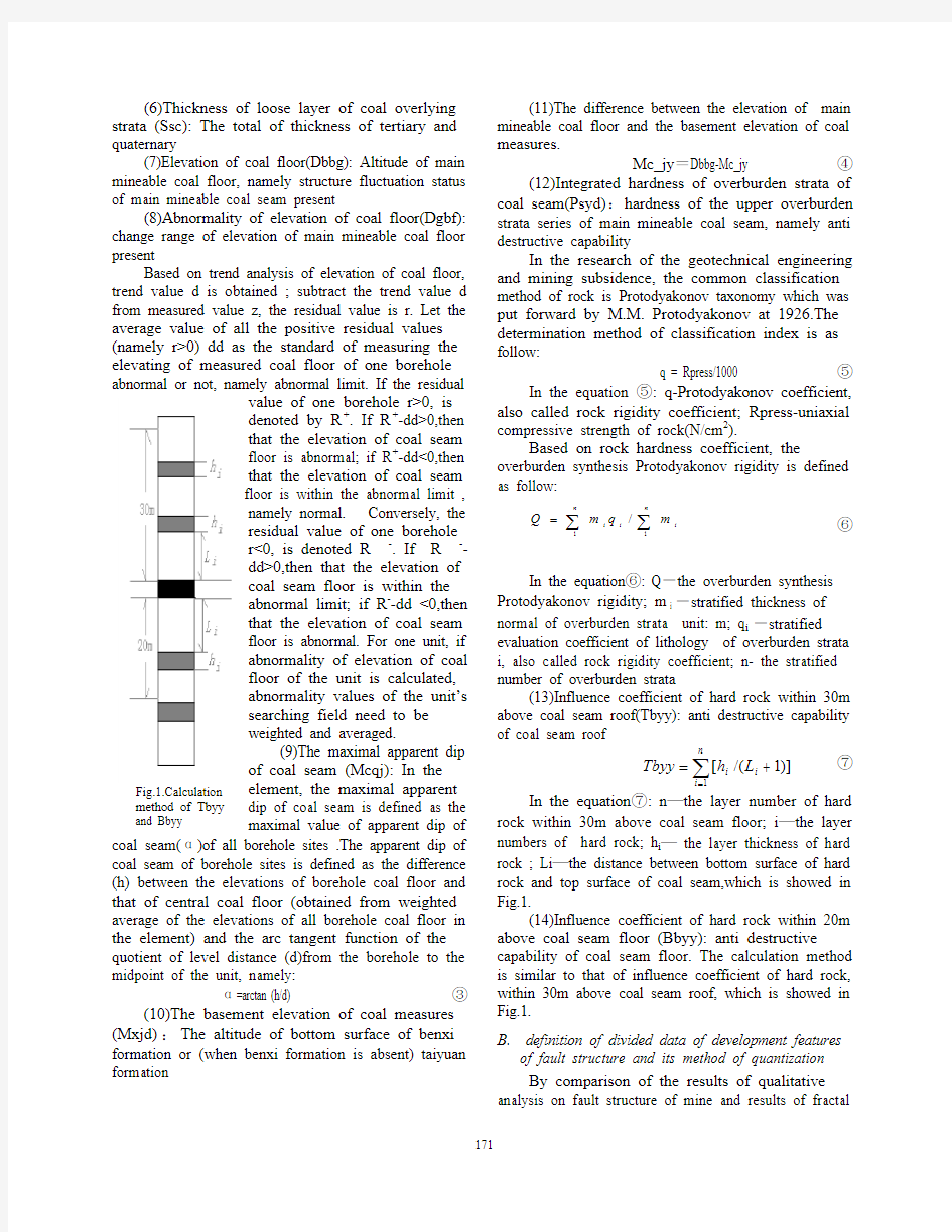
Fig.1.Calculation
method of Tbyy and Bbyy Based on rock hardness coefficient, the overburden synthesis Protodyakonov rigidity is defined as follow:
|
|
n
i
n
i i m
q m Q 1
1
/
?
In the equation ?: Q ˉthe overburden synthesis Protodyakonov rigidity; m i ˉstratified thickness of normal of overburden strata unit: m; q i ˉstratified evaluation coefficient of lithology of overburden strata i, also called rock rigidity coefficient; n- the stratified number of overburden strata
(13)Influence coefficient of hard rock within 30m above coal seam roof(Tbyy): anti destructive capability of coal seam roof
| n
i i i L h Tbyy 1
)]1/([ ?
In the equation ?: n üthe layer number of hard rock within 30m above coal seam floor; i üthe layer numbers of hard rock; h i ü the layer thickness of hard rock ; Li üthe distance between bottom surface of hard rock and top surface of coal seam,which is showed in Fig.1.
(14)Influence coefficient of hard rock within 20m above coal seam floor (Bbyy): anti destructive capability of coal seam floor. The calculation method is similar to that of influence coefficient of hard rock, within 30m above coal seam roof, which is showed in Fig.1.
B.definition of divided data of development features of fault structure and its method of quantization
By comparison of the results of qualitative analysis on fault structure of mine and results of fractal
study, it is obtained that fault fractal dimension is a comprehensive embodiment of fault amount , scale ,combination form, horizontal extending length and inhomogeneity of distribution, and can be a quantitative index of complex degree of fault structure . By the research result of fractal dimension on fault fracture in DongPang mine field , it can be also proved that fault fractal dimension is a comprehensive index of fracture quantity, group number, and length of fracture trace, fracture cutting relation and inhomogeneity of fracture distribution, and evaluating complex degree of fault structure block section by fault network has the advantage that other indexes can not compare.
In order to study and compare the complex degrees of each unit fracture, fault fractal dimension of unit Ds is measured by grid-covered method. The calculation method is : let each side of the element into two, can be divided into 4 square lattices whose side length is 1/2 of side length of unit(denoted by R ),the number of lattices of faults entering N(R/2) is calculated out, then , each of square lattices with the side length , 1/2 of side length of unit are divided respectively into square lattices whose side length is 1/4 of side length of unit, and the number of lattices of faults entering N(R/4) is calculated out respectively,… analogy in turn, namely side length of square lattices is changed by the rate of 1/2, and the number of relevant lattices is calculated N(r) .If there is a self-similar structure in faults of research are, there is the following relation:
lnN(r)=A+Bln(r) ?
Based on least square method or one-dimensional linear regression analysis, can be obtained the slope of straight line and correlation coefficient of linear equation and standard deviation of it, absolute value of linear slope, namely fault fractal dimension of research area, namely : Ds = |B|
In order to compare, were calculated out the indexes of evaluation unit(Dcts), including its fault density(Dcmd), number of faults(Dcts), fault length(Dccd), fault throw(Dcdj), fault intensity(Dcqd ) etc. Among them, fault intensity is defined as:
| u n
i i i L h Dcqd 1
][ ?
In the equation ?, n üfault quantity of unit; i üfault number; hi üfault throw; Li ülength of evaluation unit.
III.
A NALYSIS ON THE MAIN AFFECTING FACTORS
OF MIDDLE AND SMALL SIZE FAULT STRUCTURE
Mining area one, two, three, six, seven and nine have been exploited in DongPang mine field at present. Moreover, part of middle and small faults are disclosed
in some roadways .The area is regarded as proved area which is divided into 73 grids with 4004h 400,20 evaluation index values of every unit are calculated ,can be obtained the original data of quantitative analysis. Due to the limited space, they are not been listed here. And then, based on the quantitative analysis methods of gradual regression analysis method, grey relational analysis method and corresponding analysis method etc, main controlling factors of affecting the development of middle and small faults in DongPang mine field are screened out to lay a foundation for development degree prediction of fault fracture in non-mining areas.
A.analysis method of gradual regression
According to the need of analysis method of gradual regression, the factors need to be predicted are for dependent variable, and that prediction factors for independent variable. A threshold is given(F*), then according to the threshold, independent variable is screened automatically by computers ,the main perdition factors are reserved, independent variable ,secondary or independent are rejected, finally a best regression equation is presented.
Here fault fractal dimension is regarded as dependent variable, other 19 indexes are regarded as independent variable which have analyzed by gradual regression.
According to the need of calculation program, dependent variable must be at the last column, so the movement of fault fractal dimension Dcfw(X14) is changed into (X20)
(X14)--fault throw Dcdj (X15) —cap thickness of bedrock
(X16)—coal seam-base thickness Mc_jy (X17)—hard rock effect of roof Tbyy; (X18)—hard rock effect of floor (X19)—thickness of unconsolidated layers ?When F*=0.1, regression equation is: Y=0.2368411+0.00099X(2)-0.052X(9)+0.002X(11)+0.047X(12)+0.0088X(13)-0.005X( 14)+0.014X(17)-0.03X(18)-0.00059X( 19)
Multiple correlation coefficient = .818163172251713
Standard deviation = 3.00181281861453E-02 F checkup value =14.17305
When multiple correlation coefficient is 81.8%, shows that in the equation, the relation of independent variable combination and the relation of dependent variable are close. Significance test is done, F0.05(20,60)=1.75;F0.01(20,60)=2.20;r0.05(80)=0.352;r0.01(80)=0.413 are obtained by lookup. This shows that whether F test or test of correlation coefficient, when confidence level is 0.01, regression equation is obvious, that is to say, the equation is credible.
By the analysis on the equation, the influencing factors of fault fractal dimension are: (X2)—abnormality of thickness of coal measures (X9)—comprehensive hardness of overlying strata (X11)—fault length
(X12)—fault number Dcts (X13)—fault density Dcqd (X14)üfault throw Dcdj;(X17)—hard rock effect of roof (X18)—hard rock effect of floor Bbyy(X19)—thickness of unconsolidated layers Ssc
When in the range of 0.2-3,class indexes of fault are always preserved in the regression equation; When F* is taken respectively as 2.5 and 3, only class indexes of fault are left(X11)-(X13).This showed that fault fractal dimension and class indexes of fault are in a close relation.
Besides class indexes of fault, the other independent variables which are chosen are all for medium indexes of structure, namely, comprehensive hardness of overlying strata , effect coefficient of hard rock of roof, effect coefficient of hard rock of floor, abnormality of thickness of coal measures and thickness of unconsolidated layers.
B. grey correlation analysis method
Correlation analysis of grey system is mainly used to analyze dynamic relationship between various factors of system and its features which changes with time, and then the main factors of system can be obtained. In the process of development of system, if the change situation of the two factors is basically consistent, namely, synchronous change degree is higher, and then it is considered that the relationship of the two factors is close or correlation degree is larger; or correlation degree of the two factors is smaller. So, correlation degree is quantitative description of correlation degree between various factors of system. Because fault fractal dimension is comprehensive embodiment of fault number, scale, combination form, level extension length and heterogeneous distribution, and can be a quantitative index ,therefore ,it is used as mother factor, and the other 19 factors likely related to fault fractal dimension are used as son factors.
Correlation degrees between fault fractal dimension (X14) and its influencing factors are obtained by computing as follows: G(14,1)=.875; G(14,2)=.305; G(14,3)=.873; G(14,4)=.555;
G(14,5)=.861; G(14,6)=.83; G(14,7)=.866;
G(14,8)=.865; G(14,9)=.872; G(14,10)=.925; G(14,11)=.918; G(14,12)=.925; G(14,13)=.864; G(14,14)=1.;
G(14,15)=.857;G(14,16)=.859;G(14,17)=.868;
(14,18)=.838; G(14,19)=.858; G(14,20)=.874?
The sorting of influencing factors of fault fractal dimension is as follows:
Fault density(X10), fault number(X12), fault length(X11), thickness of coal measures(X1), thickness of unconsolidated layers(X20), coal seam thickness(X3), comprehensive hardness of overlying strata(X9), coal seam-base thickness(X17), maximum apparent dip of coal seam(X7), basement elevation of coal measures(X8), fault density(X13), floor elevation of coal seam(X5), cap thickness of bedrock(X16), hard rock effect of floor(X19), fault throw(X15), hard rock effect of roof(X18), amplitude of floor elevation(X6), abnormality of coal seam thickness(X4) and
abnormality of coal measures(X2).
Fig.2 Forecast sub-area chat of relative complexity degree of faults in DongPang coal field. I:boundary of coal field; II:bound of goaf; III: isoclines of
fault fractal dimension; IV:faults IV.P ARTITION ESTIMATE AND FORECAST OF RELATIVE COMPLEXITY DEGREE OF FAULT STRUCTURES DongPang mine field is divided into 331 units
according to a grid spacing of 350m h 350m, including
74 units in disclosed areas. All the fault fractal
dimension values in the mine field are predicted by the above network. According to relative complexity degree of fault structures, the division standards are the
following: grade I ---fault fractal dimension value ?
0.3; grade II ---0.3?fault fractal dimension value ?0.7; grade III --- fault fractal dimension value ?0.7.
The mine f ld is divided into 3 kinds of districts (Fig.2): relatively simple district of structure---transverse shading, filling with pale green; relatively complex district of structure---cross shading, filling with peachblow; and the middle structure between the two districts ---oblique shading, filling with pale red.
Based on Fig.2, comparative development units i ie n disc in Fi According to the whole prediction values of fau fract (1)Thickness c ts abnormality,
com is a close relation between fault fractal dime values of fault class are pred R EFERENCES
[1]Benoit B. Mandelb l geometry of nature f chaos, scale invariance and i,Sun Yan,ect. Significance of ctal dimension of fault jia ,ect.fractal e weierstrass mandelbrot fractal losed areas, a majority of them are part of relatively complex districts or middle structure districts; the units whose faults are thin relatively are part of relatively simple districts. The result of prediction is coincident with the actual situation : the monoclinic area in south is greater part of relatively simple districts of structure; almost all fault-folded area in north is relatively complex districts of structure.
However, the obvious contradiction can be found g. 2: in the east segment of middle fault zone, south of mining area 9, and mining area 6 and 8 is found many of faults, but the result of prediction is relatively simple districts of structure.
lt al dimension of unit ,the contour map was plotted (Fig. 3).It showed that fault fractal dimension of a part of units is less than 0, and just in the district (in Fig. 3,the district with the cross shading ,filling with
pink ),often there are more fault development .If the units with its fault fractal dimension ?0 are also fallen under relatively complex districts of structure, the contradiction above can be solved in some extent.
V.
C ONCLUSIONS
of oal measures, i prehensive hardness of overlying strata, hard rock effect of floor, hard rock effect of roof, thickness of unconsolidated layers ,thickness of coal seam , coal seam-base thickness ,are in the front rank of relational order and in the optimum regression equation respectively ; it shows that the relative complexity degree of fault structure is in association with coal measures and sedimentary characteristics of overlying strata, especially with hardness , there is more closer association.
(2)There nsion and class indexes of fault. This showed that fault length, fault density ,fault number and fault intensity comprehensively and can be indeed used as comprehensive index of fault number, fault scale, combination form,horizontal extending length and inhomogeneity of distribution.
(3)When evaluation index icted in undisclosed areas, only consider fault fractal dimension,fault length ,fault number ,fault density , fault intensity and other indexes are not necessary to be predicted one by one .And so fault fractal dimension is a reliable index of development degree of middle and -small faults in DongPang Mine Field.
rot. The fracta (updated and augmented edition)[M].New York:W. H. Freeman and Company ,1983.
[2]Turcotte D L. Implication o fractal statistics in geology[J].Global and Planetary Change ,1990,3(3):301-308.
[3]Li Ben-liang,Zhang Xi-hu dimension value of fault systems in evaluating natural resources with tibet as an example[J]. Geological journal of china universities ,1999,5(1):17—21.
[4Lu xin-wei and ma dong-sheng. fra systems and antimony deposit distribution in central hunan[j]. Geological review, 1998, 44(5)? 542—546.
[5]Shen zhongmin; feng zujun zhou guang dimension of fault system and oil field distribution[J]. Earth science, 1995,20(1):75—78.
[6]Berry m v, lewis z v. on th function[J]. proceedings of the royal society of london(series a). mathematical and physical sciences ,1980,370:459—484.
Fig.3 Isoclines of forecasting the fault fractal dimension
I:boundary of coal field; II:bound of goaf; III: isoclines of fault fractal dimension; IV:faults
井下常用的断层性质识别方法
井下常用的断层性质识别方法 1、揭露断层的征兆 (1)煤层的顶底板岩石中裂隙显著增加,一般越靠近断层越明显。 (2)煤层产状发生显著变化。这是由于断层两盘相互错动,牵引附近煤岩层变形的结果。 (3)煤层厚度发生变化,煤层顶底板出现不平行现象。这是由于煤层较松软,或者顶底板岩石力学性质差异较大,在受到断层挤压和揉搓时,不同部位存在差异所致。 (4)煤层结构发生变化,滑面增多,出现揉皱和破碎现象,煤呈鳞片状、粉末状,常有效褶曲出现。 (5)在大断层附近常半生一系列小断层,这些小断层与大断层性质相同,是大断层伴生小构造。 (6)充水性强的矿井,在巷道接近断层时,常出现滴水、淋水以致涌水等现象。这是由于上部含水层或者其他水体沿断层附近裂隙下渗所致。 2、断层性质区分 (1)井下实地观察:查明断层两盘相对位移的方向,也是确定断层类型不可缺少的一向工作。落差小于巷道高或小于煤厚,根据上下盘移动方向,可以直接判定;落差大于巷道高或大于煤厚,根据顶底板岩性或者摩擦面判定。 断层标志,有一部分可以直接或间接地指示断层两盘相对为位移的方向。例如,断层面上的擦痕、阶步和反阶步。在确定断层两盘相对位移方向时,必须充分注意到断层在不同侧面造成的地层效应,综合分析断层多方面的标志,才能正确地确定断层两盘相对位移的方向。当测定了断层的产状和确定了断层两盘相对位移的方向,就可定出断层的类型,包括正断层、逆断层、平移断层和枢纽断层等。
1、正阶布 2、反阶布 3、擦痕及两盘运动 方向 (2)层位对比法:根据巷道揭露的断层两盘煤岩层位,进行对比,再根据断层的产状,确定断层的性质。 利用层位对比法,可初步判定断层性质(存在标志层的判定会更加准确) (3)伴生派生构造判断法:断层附近常伴生派生一些小型列些构造或者拖拽牵引,这些构造在成因上与断层有密切的联系,可根据这些构造的产状,从而推测出断层的产状。
断层、理解分析用图解
断层、理解分析用图解 [导读]断层的分析及图解主要是查明断层的性质及断层变位的各种基本要素。本文对断层的各项基本要素的分类、断层的分析法及图解法及应注意的问题几个方面进行了详细阐述。 断层的分析及图解主要是查明断层的性质及断层变位的各种基本要素。在野外实地观察、测量断层的性质及其某些基本要素是断层研究中的最主要和最基本的方法。但单是野外观察是不够的,因直觉往往易形成错觉,而且大多数基本要素须经过一定的分析或图解才能获得,当编绘各类投影图及剖面图时,就需要进行这种分析或图解。 一、断层的各项基本要素包括两大类,即断距及位移。 (一)断距又称视断距,为断层两盘标准层的错开距离,一般不一定代表断层的真实位移。又分四种(图1):水平断距(l),垂直断距(Z),倾斜断距(D)及法线断距或层位断距(N)。四者的关系如下: N=Dsin(β±α)(1) l=Dcosβ(2) Z=Dsinβ(3) 式中:α-标准层倾角; β-断层面倾角。 当断层与标准倾斜同向时,(1)式中的α前用负号;异向时,用正号。 图1 断层的断距
l:水平断距;Z:垂直断距;D:倾斜断距;N:法线断距 (二)位移又称真断距或位移矢量(R),为沿断层运动方向的位移,即同一点自断层运动前的位置移至断层运动后的位置的距离。矢量R又有如下的分量(图2):沿走向位移(λ),面向断层面,向右为正,向左为负,倾斜位移(n),向上为正,向下为负,垂直位移(H),向上为正,向下为负;水平位移(R′),倾斜水平位移(b),向下盘方向为正,反之为负。 图2 把位移矢量R分解 为断层裂缝平面上及空间的组成部分 矢量R的空间位置依下列三要素而定:r′角(为R′与断层走向线正方向之夹角)及θ角(R与R′之间的夹角,即R的倾角)。 上述诸要素间的关系如下: (4) (5) (6) (7)
断层的识别
断层的识别 断层类型很多,规模差别极大,形成机制和构造背景各异,因此,研究的内容、方法和手段各不相同。但是断层研究的首要环节是要识别断层和确定断层的存在。虽然断层可以通过分析和解译航卫片、物探图、地质图和有关资料得以确定或推定。但识别和确定断层存在的主要方式是进行野外观测。 断层活动总会在产出地段的有关地层、构造、岩石或地貌等方面反映出来,形成了所谓的断层标志,这些标志是识别断层的主要依据。 地貌标志(1) 断层崖由于断层两盘的相对滑动,断层的上升盘常常形成陡崖,这种陡崖称为断层崖。盆地与山脉间列的盆岭地貌是断层造成一系列陡崖的典型实例。 断层三角面断层崖受到与崖面垂直方向水流的侵蚀切割,乃形成沿断层走向分布的一系列三角形陡崖,即断层三角面。 1.jpg 地貌标志(2) 错断的山脊往往是断层两盘相对平移的结果。 横切山岭走向的平原与山岭的接触带往往是规模较大的断裂。
串珠状湖泊洼地往往是大断层存在的标志。这些湖泊洼地主要是由断层引起的断陷形成的。 泉水的带状分布往往也是断层存在的标志。念青唐古拉南麓从黑河到当雄一带散布着一串高温温泉(右图),是现代活动断层直接控制的结果。 水系特点断层的存在常常影响水系的发育,引起河流的急剧转向,甚至错断河谷。 构造标志 如果线状或面状地质体在平面上或剖面上突然中断、错开,不再连续,说明有断层存在。右下图示断层造成的构造线不连续现象。为了确定断层的存在和测定错开的距离,在野外应尽可能查明错断的对应部分。 构造强化是断层可能存在的重要依据。构造强化现象包括有:岩层产状的急变和变陡;突然出现狭窄的节理化、劈理化带;小褶皱剧增以及挤压破碎和各种擦痕等现象。 构造透镜体是断层作用引起构造强化的一种现象。断层带内或断层面两侧岩石碎裂成大小不一的透镜状角砾块体,长径一般为数十厘米至二、三米。构造透镜体有时单个出现,有时成群产出。构造透镜体一般是挤压作用产出的两组共轭剪节理把岩石切割成菱形块体后,
过断层安全技术措施(正式)
编订:__________________ 单位:__________________ 时间:__________________ 过断层安全技术措施(正 式) Deploy The Objectives, Requirements And Methods To Make The Personnel In The Organization Operate According To The Established Standards And Reach The Expected Level. Word格式 / 完整 / 可编辑
文件编号:KG-AO-3833-39 过断层安全技术措施(正式) 使用备注:本文档可用在日常工作场景,通过对目的、要求、方式、方法、进度等进行 具体、周密的部署,从而使得组织内人员按照既定标准、规范的要求进行操作,使日常 工作或活动达到预期的水平。下载后就可自由编辑。 工作面两道揭露的断层有13条,落差最大为4.2m,回采过程中将有较大影响,应视具体情况,采取相应措施。 ⑴煤遇翻顶断层时,提前断层面5倍断层落差处开始挑顶,确保过断层面后及时跟上煤层顶板。 ⑵过断层区域仰采、大倾角时使用好防护网、人行道防护网和缓冲帘,打锚杆护帮(锚杆间排距0.5m,上排眼距顶板0.2m,底眼距输送机≯0.8m,使用玻璃钢锚杆〔长2.0m〕慢速树脂药卷〔初凝时间110ms〕全长锚固)。采煤机割煤后滚筒通过后立即伸出前探梁,移架距采煤机后滚筒4~6架,煤壁区片帮、端面距超过规定时必须带压移超前架。若移架速度跟不上采煤机运行时,要控制采煤机速度,必要时停机移架,采煤机停机时移架及时跟上。
小断层
Research on Development Character of Middle and Small Size Fault Structure in DongPang Mine Field on Fractal Theory Sun Xue-yang School of Geology and Environment Xi’an University of Science and Technology Xi’an, China sunxy02211@https://www.360docs.net/doc/4d13873609.html, Xia Yu-cheng School of Geology and Environment Xi’an University of Science and Technology Xi’an China xiayc@https://www.360docs.net/doc/4d13873609.html, Abstract—Middle and small size fault structure is the key geological factor affecting the safety production of DongPang mine field.Finding out development character of middle and small fault structure in DongPang mine field is to provide the geological premise for mining design of coal mine and working face layout. Based on the analysis of real data, 20 factors affecting the development of middle and small fault structure are summarized. And on the fractal theory, the fault fractal dimension value is worked out ;and then the key factors affecting the development of middle and small fault structure are filtrated by means of regression analysis, finally the relation of fault fractal dimension and the key factors affecting fault structure development is analyzed by using the grey relational analysis method. The results showed that fault fractal dimension can be used as comprehensive index of quantity, scale, combination form, horizontal extending length and inhomogeneity of distribution of fault structure. And the bigger its value is, the more fault structure is developed. Hence, fault fractal dimension is a reliable index denoting development degree of middle and small fault structure in DongPang mine field. Keywords: fault fractal dimension; middle and small size fault structure; fractal theory; DongPang mine field of China I.I NTRODUCTION A lot of researches have indicated that the distribution of fault structure and geometric shape have the fractal structures[1-2]. Fractal feature of fault structure with different scales of crust has been studied respectively by Turcotte, Li Ben-liang, Lu Xin-wei, Shen Zhong-min etc, it was pointed out that the spatial distribution characteristics and self-similarity of fault structure can be described quantitatively by fractal value, Berry and Lewis hold that the size of fractal value of fault system is a comprehensive embodiment of quantity, scale, combination form of fault and dynamic mechanism.[3-6] Fault structure in DongPang mine field developed very well, according to statistics there are nearly 200 faults. Middle and small fault structure is the key geological factor affecting coal production. According to the data of the districts where the middle and small fault structure had been disclosed, influencing factors of fault development are analyzed and summarized; in unmined districts, the degree of medium feature. And so analyzing the feature of middle and small fault structure development is very important and basic work. Based on Fractal Theory in the paper, research shows that fault reference cone is reliable index denoting development degree of middle and small fault structure. II.T HE FACTORS BEING fault development will be forecast by structural LIKELY TO AFFECT THE S ng mine itions of the factors affecting the d ture easures(Mxhd):the total ormality of the thickness of coal mea Mxhd_pjz ?In the equation of co ness of main mine of the thickness of coal seam Mchd_pjz ?In the equat of co overlying strata (Jyh DEVELOPMENT OF MIDDLE AND SMALL FAULT TRUCTURE AND QUANTIZATION OF ITS INDEXES Proceed from the actual conditions of DongPa field, the factors which are likely to affect middle and small fault structure development are fined for 14 indexes, and the features of fault development are fined to 6 indexes. A.The defin evelopment of middle and small fault struc and the method of quantization (1)The thickness of coal m of thickness of shanxi formation and taiyuan formation (2)Abn sures(Mxhdyc): The difference between borehole thickness of coal measures and average thickness of coal measures in DongPang mine field Mxhdyc˙Mxhdˉ ? , Mxhd_pjz is average thickness al measures in DongPang mine field (3)coal seam thickness(Mchd): thick able coal seam (4)Abnormality (Mchdyc): the difference between borehole or unit thickness of coal seamand average thickness of coal seam in DongPang mine field Mchdyc˙Mchdˉ ion?, Mchd_pjz is average thickness al seam in DongPang mine field (5)Bedrock thickness of coal d):Total thickness of strata above main mineable coal seam, namely not including thickness of overlying strata series of main mineable coal seam of loose overburden layer 2010 International Conference on Computing, Control and Industrial Engineering
如何识别断层
如何识别及描述断层 断层:断层与节理同属断裂构造,而断层往往是节理的进一步发育所致。或者说,当节理发生位移,两壁有所错动时,即称为断层。断层是野外常见的一种重要地质现象。 野外地质填图时遇到断层,应如何研究呢?首先要确定断层的几何要素,其内容包括下列各点: 1、断层面。所谓断层面,就是两部分岩块沿着滑动方向所产生的破裂面。断层面的空间位置也像地层的层面一样,是由其走向和倾向而确定的。但断层面并非一个平整的面,往往是一个曲面,特别是向地下沿伸的那一部分,产状可以有较大的变化。此外,断层面不是单独存在的,往往是有好几个平行地排列着,构成所谓断层带,又由于断层带上两壁岩层的位移错动,使岩石发生破碎,因此又称为断层破碎带。其宽度达几米、甚至几十米。一般情况下,断层的规模愈大,断层带的宽度也愈大。 2、断盘。断层面两侧相对移动的岩块称为断盘。由于断层面两壁发生相对移动,所以断盘就有上升盘和下降盘之分。在野外识别时,按其位于断层面之上者称上盘;位于断层面之下者称下盘。当断层面垂直时,就无上盘或下盘之分。 3、断层线。断层面与地面相交之线,称断层线。 4、位移。这是断层面两侧岩块相对移动的泛称。在野外观察断层时,位移的方向是必须当场解决的问题之一。特别遇到开矿时,一旦遇到矿脉(或矿层)中断,往往是断层位移所致,需要立即追查。
追查的办法是运用两侧岩层的层序关系来判断或抚摸断层面上的擦痕等来确定。 在野外地质填图时,如何注意断层?怎样研究断层?观察什么内容?此类问题必须熟练掌握,现分述如下:先讨论断层的标志及两盘相对位移问题。 (1)构造(线)不连续。各种地质体,诸如地层、矿层、矿脉、侵入体与围岩的接触界线等都有一定的形状和分布方向。一旦断层发生,它们就会突然中断、错开,即造成构造(线)的不连续现象,这是判断断层现象的直接标志。 (2)地层的重复或缺失。这是很重要的断层证据。虽然褶皱构造也有地层的重复现象,但它是对称性的重复;而断层的地层重复却是单向性的。至于地层的缺失,凡沉积间断或不整合构造也可造成,但这两类地层缺失都是区域性的,而断层造成的地层缺失则是局部性的。关键的问题,填图者应对区域内的地层系统及其分布情况有一个较为全面的了解(可以在填图准备时查阅地层表、剖面、地层柱状图之类)。利用地层的重复或缺失不仅是判断断层的重要手段,而且是判断断层两盘相对动向的重要方法,借此还可以确定断层的性质——正断层,还是逆断层? (3)断层面(带)上的构造特征。这是识别断层的直观证据,即在眼前“方寸”之地内所能见到的若干构造现象,最常见的有以下几种: ①断层擦痕:就是断层两侧岩块相互滑动和磨擦时留下的痕迹,由一系列彼此平行而且较为均匀的细密线条组成,或为一系列相间
隧道通过断层富水地带的案例分析
隧道富水断层破碎带初期支护技术案列分析摘要沿海某高铁隧道富水断层破碎带施工中,按照“管超前、严注浆、短开挖、弱爆破、强支护、快封闭、勤测量、速反馈”的施工原则,采用了超前小导管注浆支护、结合帷幕注浆封堵、钢拱架加强支护,在高水压、大水量、岩体极度破碎的条件下,施工安全和质量得于保证。本文在设计参数的选取,注浆施工工艺、关键技术的突破、注浆效果等方面做了较详细的阐述。 关键词隧道富水断层破碎带超前小导管注浆支护 前言 为解决长大隧道常遇富水断层破碎带的问题,采用超前小导管注浆支护、结合帷幕注浆封堵、钢拱架加强支护等措施进行了治理,有效地固结了断层破碎带,形成应力圈,解决了隧道不良地质引起施工安全和质量问题。 一、工程概括 沿海某高铁隧道全长6852m。其中,Ⅱ级围岩5769m,Ⅲ级围岩833m,Ⅳ级围岩125m,Ⅴ级围岩125m。隧道主要地质断层构造情况如下: (一)DK145+795~+825段构造节理密集带,因岩体破碎,地下水相对较发育,水位埋深31.8m。根据抽水试验成果,该段预计最大涌水量为1200 m3/d,属大股状涌水,洞室开挖时,可能出现局部射流现象。 (二)DK146+100~DK147+300段地表为剥蚀洼地,燕山期花岗岩和小溪组凝灰熔岩在本段接触,岩体完整性较差,两侧山体的基岩裂隙水可以沿节理、裂隙等构造面向此段汇集。根据抽水试验成果,该段预计最大涌水量为2000 m3/d,属大股状涌水,洞室开挖时,可能在裂隙较发育区出现局部射流现象。 以上两段断层破碎带的围岩结构松散,本身的支撑能力较差,又具有富水性,使围岩的稳定能力大大降低,若初期支护结构施工不到位,容易产生突泥、突水、围岩失稳,严重威胁施工质量和安全。 二、施工技术方案选择 针对上述地质断层构造情况,结合施工生产要素及施工生产能力,按照“管超前、严注浆、短开挖、弱爆破、强支护、快封闭、勤测量、速反馈”的施工原则,在采用帷幕注浆封堵、超前小导管注浆支护、钢拱架加强支护、加强引排水等措施保护下,采用三部台阶法进行施工。 地质预报方法:采用超前地质钻探等手段,提前了解开挖工作面前方地质情况。 辅助工法:帷幕注浆封堵、超前小导管注浆支护、钢拱架加强支护。 开挖方法:三部台阶法,掘进循环进尺控制在0.5m~1.0m。 支护方式:采用型钢钢架、钢筋网、喷射混凝土等多种支护手段,构成强支护体系。 在开挖和支护过程中要重视加强监控量测,根据支护的位移量测结果,评价支护的可靠性和围岩的稳定状态,及时调整支护参数,确保施工安全。 衬砌施工:开挖后尽早施作仰拱,待围岩和支护变形基本趋向稳定后施作复合式衬砌,形成封闭衬砌。 三、断层破碎带初期支护施工技术 (一)超前地质预报 (1)根据地质资料分析,本隧道在断层破碎带地段采用TSP202超前地质预报系统预报,辅以地质素描、超前水平钻孔。目的是超前探测地层岩性、断层、软弱层的位置、岩体完整程度、断裂带位置、宽度、
地质构造与地质图识别
3 地质构造与地质图识别 本章重点、难点 ?地层地质年代的确定; ?判读地质年代表; ?认识地质构造的各种类型、地质构造与公路工程的关系; ?节理玫瑰花图的绘制 ?阅读地质图 3.1 地史的基本知识 几个概念的区分: 地史---地壳发展演变的历史叫做地质历史 绝对地质年代----地质事件发生(或地质体形成)的时代,是用距今多少年以前来表示,是通过测定岩石样品所含放射性元素确定的; 相对地质年代----地质事件发生(或地质体形成)的先后顺序,是由该岩石地层单位与相邻已知岩石地层单位的相对层位的关系来决定的。 一般以应用相对地质年代为主. 一、地层的地质年代 地层和岩层的区别: 岩层-由两个平行或近于平行的界面(岩层面)所限制的同一岩性组成的层状岩石,称为~,岩层是沉积岩的基本单位而没有时代的含意。 地层-在地质学中,把某一地质时期形成的一套岩层及其上覆堆积物统称为那个时代的地层。 二、地层的相对地质年代 ◆沉积岩相对地质年代的确定 ◆岩浆岩相对地质年代的确定 ◆绝对地质年代的确定 (一)沉积岩相对地质年代的确定 1.地层层序律:沉积岩在形成过程中,自然的层序总是先老后新(下老上新). 2.标准地层对比法:一定区域内,同一时期形成的岩层特征基本一致。可以以岩石的组成、结构、构造等特点,作为岩层对比的基础. 但此方法具有一定的局限和不可靠性。 3.层位接触关系对比法:不整合接触就成为划分地层相对地质年代的一个重要依据。 4. 生物层序法:化石是确定地质年代的重要依据. 沉积岩的接触关系 地壳上升可以形成侵蚀面,然后下降又被新的沉积物所覆盖,这种埋藏的侵蚀面称不整合面.上下两套岩层之间具有埋藏侵蚀面的这种接触关系,称不整合接触. (1)角度不整合:埋藏侵蚀面将年轻的、新的、变形较轻的沉积岩同倾斜或褶皱的沉积岩分开,不整合面上下岩层之间有一角度差异。 (2)平行不整合(假整合):上下两套岩层之间产状一致、互相平行,但在岩性时代、古生物特征上是不连续的,中间发生过沉积间断。 (3)整合:上下两套岩层之间产状一致、互相平行,且在岩性时代、古生物特征上是连续
断层的(野外)识别标志
断层的(野外)识别标志 断层类型很多,规模差别极大,形成机制和构造背景各异,因此,研究的内容、方法和手段各不相同。但是断层研究的首要环节是要识别断层和确定断层的存在。虽然断层可以通过分析和解译航卫片、物探图、地质图和有关资料得以确定或推定。但识别和确定断层存在的主要方式是进行野外观测。 断层活动总会在产出地段的有关地层、构造、岩石或地貌等方面反映出来,形成了所谓的断层标志,这些标志是识别断层的主要依据。 地貌标志(1) 断层崖 由于断层两盘的相对滑动,断层的上升盘常常形成陡崖,这种陡崖称为断层崖。盆地与山脉间列的盆岭地貌是断层造成一系列陡崖的典型实例。 断层三角面 断层崖受到与崖面垂直方向水流的侵蚀切割,乃形成沿断层走向分布的一系列三角形陡崖,即断层三角面。 地貌标志(2) 错断的山脊 往往是断层两盘相对平移的结果。 横切山岭走向的平原与山岭的接触带 往‘往是规模较大的断裂。 串珠状湖泊洼地 往往是大断层存在的标志。这些湖泊洼地主要是由断层引起的断陷形成的。 泉水的带状分布 往往也是断层存在的标志。念青唐古拉南麓从黑河到当雄一带散布着一串高温温泉(右图),是现代活动断层直接控制的结果。 水系特点 断层的存在常常影响水系的发育,引起河流的急剧转向,甚至错断河谷。 构造标志 如果线状或面状地质体在平面上或剖面上突然中断、错开,不再连续,说明有断层存在。右下图示断层造成的构造线不连续现象。为了确定断层的存在和测定错开的距离,在野外应尽可能查明错断的对应部分。 构造强化是断层可能存在的重要依据。构造强化现象包括有:岩层产状的急变和变陡;突然出现狭窄的节理化、劈理化带;小褶皱剧增以及挤压破碎和各种擦痕等现象。 构造透镜体是断层作用引起构造强化的一种现象。断层带内或断层面两侧岩石碎裂成大小不一的透镜状角砾块体,长径一般为数十厘米至二、三米。构造透镜体有时单个出现,有时成群产出。构造透镜体一般是挤压作用产出的两组共轭剪节理把岩石切割成菱形块体后,其楞角又被磨去形成的。包含透镜体长轴和中轴的平面,或与断层面平行,或与断层面成小角度相交。 在断层带中或断层两侧,有时见到一系列复杂紧闭的等斜小褶皱组成的揉褶带。揉褶带一般产于较弱薄层中,小褶皱轴面有时向一方倾斜,有时陡立,但总的产状常常与断层面斜交,所交锐角一般指示对盘运动方向。 断层岩的发育和较广泛产出也是断层存在的良好判据。 地层标志 地层的重复和缺失是识别断层的主要依据。 岩浆活动和矿化作用标志 大断层尤其是切割很深的大断裂常常是岩浆和热液运移的通道和储聚场所,因此,如果岩体、矿化带或硅化等热液蚀变带沿一条线或带断续分布,常常指示有大断层或断裂带存在。一些放射状或环状岩墙也指示放射状断裂或环状断裂的存在。 岩相和厚度标志 如果一个地区的沉积岩相和厚度沿一条线发生急剧变化,可能是断层活动的结果。断层
断层破碎带施工方案
二郎山隧道断层破碎带施工方案 一、编制依据 1、雅安至康定高速公路控制性工程二郎山隧道段C2标试验工程施工图设计资料; 2、现行公路工程施工技术规范、标准及施工验收标准; 3、根据现在掌子面围岩的情况及设计地质资料; 4、我公司拥有的技术装备力量、机械设备状况、管理水平、工法、科技成果和多年积累的长大隧道工程施工经验; 5、国家及地方关于安全生产和环境保护等方面的法律法规。 二、工程概况 雅安至康定高速公路C2标段主线长9.390 km(右线K72+310~K81+700),泸定互通式立交一座,泸定连接线长4.497km,均位于四川省泸定县。主体控制性工程为二郎山特长公路隧道,全长13425米,C2标负责施工左线长度6748m,右线长度为6693m,工期66个月。 1、地形 隧址区地处四川盆地与青藏高原过渡的二郎山高中山区,地面切割强烈,山势陡峻,高差悬殊,二郎山主峰海拔3437m,与隧道口相对高差接近2000m。隧道最大埋深1469m。 2、气候 隧址区地处四川盆地中亚热带季风湿润气候与青藏高原大陆干冷气候的过度地带。二郎山东西两侧气候差异非常明显,我部施工区域位于二郎山西侧,年降雨量仅900~1000mm,降雨多集中在5~10月,雨季降雨量占全年90%以上,相对湿度66%,多年平均气温15.5℃,最高气温36.4℃,最低气温-5℃,年平均无霜期279天。 3、水文地质
和地表水直接或间接渗入补给。地下水质较好,对砼无腐蚀性,隧道主洞预测正常涌水量为59000m3/d,最大用水量82000m3/d。 4、我标段隧道通过的断裂构造统计见下表: 二郎山隧道C2标段断裂带统计 由于断层破碎带存在涌水、突泥及发生大规模隧道坍塌的危险,为确保施工过程中不发生安全事故,顺利通过断层破碎带,有效降低施工阶段发生地质灾害所引发的风险,特制定以下施工方案。 首先按照设计文件要求采用综合超前地质预报系统(主要采用TSP203及超前地质钻孔、地质雷达等)进行超前地质预测,结合地质勘测资料和地质素描对前方地质进行综合判断,根据判断结果确定是否注浆和采取哪种注浆方案,以及后续开挖过程中采取什么样的辅助措施,开挖过程中加强对开挖后的地段进行监控量测,根据量测结果指导后续施工。 1 超前地质预报 ⑴隧道开挖爆破后立即进行地质调查并进行地质素描,一般地段每10m 记录一次,地质条件变化时,增加素描。 ⑵在围岩变化处前100m预先通知西南交大超前预报单位进行超前探测,利用TSP203对前方进行探测,粗略掌握掌子面前方的不良地质分布情况。
断层识别标志
断层类型很多,规模差别极大,形成机制和构造背景各异,因此,研究的内容、方法和手段各不相同。但是断层研究的首要环节是要识别断层和确定断层的存在。虽然断层可以通过分析和解译航卫片、物探图、地质图和有关资料得以确定或推定。但识别和确定断层存在的主要方式是进行野外观测。 断层活动总会在产出地段的有关地层、构造、岩石或地貌等方面反映出来,形成了所谓的断层标志,这些标志是识别断层的主要依据。 地貌标志(1) 断层崖由于断层两盘的相对滑动,断层的上升盘常常形成陡崖,这种陡崖称为断层崖。盆地与山脉间列的盆岭地貌是断层造成一系列陡崖的典型实例。 断层三角面断层崖受到与崖面垂直方向水流的侵蚀切割,乃形成沿断层走向分布的一系列三角形陡崖,即断层三角面。 地貌标志(2) 错断的山脊往往是断层两盘相对平移的结果。 横切山岭走向的平原与山岭的接触带往‘往是规模较大的断裂。 串珠状湖泊洼地往往是大断层存在的标志。这些湖泊洼地主要是由断层引起的断陷形成的。 泉水的带状分布往往也是断层存在的标志。念青唐古拉南麓从黑河到当雄一带散布着一串高温温泉(右图),是现代活动断层直接控制的结果。 水系特点断层的存在常常影响水系的发育,引起河流的急剧转向,甚至错断河谷。 构造标志 如果线状或面状地质体在平面上或剖面上突然中断、错开,不再连续,说明有断层存在。右下图示断层造成的构造线不连续现象。为了确定断层的存在和测定错开的距离,在野外应尽可能查明错断的对应部分。 构造强化是断层可能存在的重要依据。构造强化现象包括有:岩层产状的急变和变陡;突然出现狭窄的节理化、劈理化带;小褶皱剧增以及挤压破碎和各种擦痕等现象。 构造透镜体是断层作用引起构造强化的一种现象。断层带内或断层面两侧岩石碎裂成大小不一的透镜状角砾块体,长径一般为数十厘米至二、三米。构造透镜体有时单个出现,有时成群产出。构造透镜体一般是挤压作用产出的两组共轭剪节理把岩石切割成菱形块体后,其楞角又被磨去形成的。包含透镜体长轴和中轴的平面,或与断层面平行,或与断层面成小角度相交。 在断层带中或断层两侧,有时见到一系列复杂紧闭的等斜小褶皱组成的揉褶带。揉褶带一般产于较弱薄层中,小褶皱轴面有时向一方倾斜,有时陡立,但总的产状常常与断层面斜交,所交锐角一般指示对盘运动方向。 断层岩的发育和较广泛产出也是断层存在的良好判据。 地层标志 地层的重复和缺失是识别断层的主要依据。 岩浆活动和矿化作用标志 大断层尤其是切割很深的大断裂常常是岩浆和热液运移的通道和储聚场所,因此,如果岩体、矿化带或硅化等热液蚀变带沿一条线或带断续分布,常常指示有大断层或断裂带存在。一些放射状或环状岩墙也指示放射状断裂或环状断裂的存在。 岩相和厚度标志 如果一个地区的沉积岩相和厚度沿一条线发生急剧变化,可能是断层活动的结果。断层引起岩相和厚度的急变有两种情况:一种情况是控制沉积盆地和沉积作用的同沉积断层的活
断层解剖
一、名词解释 1.翼点:位于灌弓中点上方约两横指处,由额骨、顶骨、颞骨和蝶骨相交接形成,多呈H 形,为颅骨的薄弱部分,内面有脑膜中动脉前支通过。 2.胸骨角:胸骨柄和胸骨体相连接处稍向前突称为胸骨角。 3.下颌角;下颌体和两侧的下颌支,二者相交之处称下颌角。 4.硬模外隙:硬脊膜与椎管内面的骨膜及黄韧带之间的狭窄腔隙。 5.蛛网膜下隙:蛛网膜和软脊膜之间的宽阔的间隙。 6.眶上切迹:位于眶上缘内、中1/3交界处,其中有眶上神经、眶上切迹动脉和眶上静脉 通过,此处是额部手术局部麻醉的注射部位也是额部出血的压迫点。 7.劾孔:通常位于下颌第二前磨牙根下方,下缘连线中点,距正中线约25cm,有劾神经、 血管通过。 8.危险三角:是鼻根至两侧口角区。 9.脑池:蛛网膜下隙在脑的沟、裂处扩大,形成蛛网膜下池又称脑池。 10.大脑动脉环:由前交通动脉、大脑前动脉、后交通动脉和大脑后动脉吻合处。 11.腮腺床:腮腺深面有茎突及茎突诸肌、颈内动脉、颈内静脉和后四对脑神经,共同构成。 12.横断面:又称水平断面,是指平行水平面的断面。 二、问答题 1.面颅骨、脑颅骨各有哪些组成? 成对的面颅骨:上颌骨、颧骨、泪骨、鼻骨、腭骨、下鼻甲。 不成对的面颅骨:犁骨、下颌骨、舌骨。 成对的脑颅骨:顶骨、颞骨 不成对的脑颅骨:额骨、枕骨、蝶骨、筛骨。 2.鼻旁窦有哪些? 上颌窦、额窦、筛窦、蝶窦 3.何为头皮?其特征是什么? 头皮由皮肤、浅筋膜和枕额肌及其帽状三者紧密的联合体 特征:愈合能力强 4.颈部的三角有哪些?各自通过哪些结构? 核下三角:下唇和舌尖部淋巴的少数核下淋巴结合颈前静脉。 下颌三角:下颌下腺及其周围的血管、淋巴结和神经。 颈动脉三角:静脉A及其分支,迷走神经和颈内V还有许多颈外侧深淋巴结。 肌三角:喉、气管、食管颈段和甲状腺。 枕三角:副神经臂丛和劲横A。 锁骨上三角:膈神经、锁骨下V、A和颈外侧下深淋巴结。 颈A上角:膈神经、胸导管。 5.颈部浅筋膜由浅入深分为几层?颈部间隙有哪些? 分为3层:浅、中、深。 间隙:气管前间隙、咽后间隙、锥前间隙、声间旁间隙、会厌前间隙、斜三角间隙。6.叙述脑脊液的产生及循环途径。 产生:由侧脑室脉络丛产生。 循环:经室间孔入第三脑室,汇同第三脑室脉络丛产生的脑脊液,经中脑水管入第四脑室,再汇同第四脑室脉络丛产生的脑脊液,自第四脑室正中孔和外侧孔不断流入小脑延髓池,自此池流入脊髓和脑的蛛网膜下隙,沿该隙流向大脑背面,经蛛网膜粒渗入上矢状窦归入静脉。
小江断裂带简介
小江断裂带简介 云南省境内的小江断裂是川滇活动地块和稳定的扬子地块边界,它北起滇川边界金沙江的巧家县北,向南经东川、宜良、通海、建水,最后并入红河断裂,走向近南北,平均水平滑移速率10 mm/s。自东川小江村起,小江断裂分东西两支,近乎平行向南延伸。小江断裂是一条构造成熟度较低的断裂带,带内有多条次级断层,彼此雁行排列,形态复杂,不仅断裂阶区多,断层面陡且转弯亦多,这些部位常处于闭锁状态, 应力易强烈集中而引发强震,1500年以来仅在小江断裂的云南段上就发生10多次大于6级的地震。 例如: 1500年1月4日宜良7.5级地震, 1571年 9月9日通海6.3级地震, 1588年6月18日曲江7.75级地震, 1713年寻甸6.76级地震, 1725年万寿山6.75级地震, 1733年东川7.75级大地震, 1763年12月30日江川6.5级地震, 1789年6月7日华宁西北7.0级地震, 1799年石屏宝秀7.0级地震, 1833年9月6日嵩明8.0级大地震, 1887年12月16日石屏7.0级地震, 1909年5月11日华宁6.5级地震, 1966年2月5日东川6.5级地震, 1970年1月4日通海7.7级地震。 1500年以前小江断裂上也曾发生过许多次大地震,例如,1377年 (明洪武十年) 江川地震,明星弯子沟一个村在地震陷落入湖中 (云南省江川县志) 。历史上俞元古城可能在北魏至唐代之间一次大地震中沉入抚仙湖。 历史上对1833年9月6日 (清道光十三年) 云南嵩明州杨林8级地震有较详细的记载。“计十余州县相次厄,或裂或坟,或高者谷,或渊者陵,滇池水腾,震延千里。嵩明等州县计倒瓦草房八万七千六百二十余间,压死六千七百余人”。
褶曲和断层的处理
褶曲的处理 通过对褶曲的判断、观测、探测,已基本查明它的位置、方向及产状变化。在此基础上可对褶曲采取措施进行处理。 1.大型褶曲 (1)褶曲轴线作为井田边界。有些大型向斜,由于埋藏较深,开采困难,多作为井田边界,其两翼分别由两个或几个井田开采。有些大型宽缓背斜,两翼煤层距离较远,井下难以形成统一的生产系统,可以褶曲轴为界,两翼分别有两个井田开采。 (2)大型褶曲在井田开拓部署中的处理方法。不是所有的大型褶曲都必须作为井田边界,在有的井田内也可以有大型褶曲存在。若在井田内有大型背斜构造,开拓系统中常把总回风巷道布置在背斜轴附近,两翼煤层均可利用。有些位于向斜构造的矿井,常把运输巷道布置在向斜轴部附近,用一条运输巷解决向斜两翼的运输问题。 如果利用立井或斜井开拓,井筒位置最好不要布置在向斜附近,因为这种井筒布置须留较大的保护井筒,损失煤炭资源。大型向斜的煤层顶板压力常有增大现象,必须加强支护,否则极易发生垮塌事故。在高瓦斯矿井中,若岩层透气性差,背斜常是瓦斯突出危险区,应引起足够重视。 2.中型褶曲 (1)以褶曲轴线作为采区中心布置采区上山或下山。对开阔的平缓褶曲,以向斜轴部作为采区中心,向两翼布置工作面,采区走向长可达1000m以上(图6-12)
(2)以褶曲轴作为采区边界。在较紧闭的褶曲,次一级构造往往发育,因此常以褶曲轴部作为采区边界(图6-13) (3)工作面直接推过褶曲轴。当褶曲较宽缓,而规模不太大时,可布置单翼采区,工作面直接摔倒过褶曲轴部。 3.小型褶曲 (1)采面重开切眼生产。在小型褶曲发育地区,常见到煤层突然增厚或变薄,甚至不可采,使工作面无法通过,需要重新开掘切眼进行生产。 (2)采面运输巷改造取直。煤矿要求运输巷在60m内不能有大的弯曲,弯曲过多无法使用。由于小褶曲存在,使煤层平巷弯弯曲曲,为满足生产要求,巷道需要改造取直。 断层的处理 1.开拓设计阶段对断层的处理 (1)井田边界和采区边界的确定。凡是井田内遇到落差大于50m的特大型断层时,应以该大型断层作为井田边界。如河北峰峰矿区井田划分(图6-19)多以大断层为界。
野外识别断层的主要依据
断层的识别 1. 地貌标志 构造地貌是确定断层存在的重要标志,构造地貌包括由挽近时期(一般指第四纪以来(有时新近纪以来)地壳运动的时期)断层活动直接形成的动态构造地貌和地质历史时期形成的断层经外营力塑造的静态构造地貌。 它们都能清楚地显示断层的存在,为观察和确定断层提供了重要线索。 (1) 断层崖:通常是挽近活动断层面形成的陡崖。正断层相对容易形成,发育于盆地、平原与山地(脉)之间,如图一、图二所示。 图一滇池断层崖 图二华山断层崖 (2)断层三角面:通常是挽近活动断层面形成的陡崖受与崖面垂直方向的水流侵蚀切割、形成的沿断层走向分布的一系列三角形陡崖。也发育于盆地、平原与山地(脉)接合部,如图三所示。
图三断层三角面 (3)错断山脊:通常是挽近平移活动断层相对平移错动,造成某一方向的山脊发生突然的、有规律的错断,如图四所示。 图四错断山脊示意图 (4)横切山岭走向的平原与山地的接触带,如图五所示。
图五横切山岭走向的平原与山地的接触带 (5) 串珠状湖泊-洼地 由大断层引起的断陷或破碎带形成的湖泊、洼地,在走向上呈线状、串珠状分布,单个湖泊、洼地也具有定向的特点,如图六所示。 图六直线状洼地 (6) 带状分布的泉水 泉水(点)呈带状、线状分布也是断层存在的标志之一,温泉一般是现代活动断层重要证据,如图七所示。
图七串珠状分布的泉水 (7) 错断的水系、河流 断层的存在常常影响水系的发育,引起河流的急剧转向、甚至切断河谷,如图八所示。 图八错断的河流 2 地质标志 (1) 错断线状、面状地质体 先于断层形成之前的线状、面状地质体(如地层、矿层、岩脉、侵入接触面、劈理或相带界线)被之后断层切割后,在平面、剖面上突然中断、错开而不连续现象,如图九所示。
滑坡的野外鉴别
滑坡的野外鉴别 滑坡的发育过程是受其内在地质条件和各种外界因素所控制的,滑动发生后会在地表留下各种滑坡构造形迹。研究这些滑坡构造形迹的展布规律和特征,进行滑坡的野外鉴别,是研究滑坡形成机制和进行滑坡防治的基础和前提。滑坡的鉴别也是工程地质勘察的主要内容之一。如果对于滑坡或易滑动的山坡缺乏正确的认识,将工程建筑物设置在易滑动地段,在施工或营运过程中可能会引起古老滑坡的复活或产生新的滑坡。这将对工程造成极大的危害。有的工程项目因产生滑坡而被迫迁移;有的工程则因整治滑坡而增加投资,甚至延误工期。 (一)野外鉴别方法 1.地层岩性 地层岩性是产生滑坡的物质基础。研究结果表明:一定地区的滑坡发生于一定的地层之中。滑坡的产生多与泥质地层的存在有密切的关系。这些地层中容易产生滑坡的主要原因是此类地层岩性软弱。在水和其他因素的影响下,往往构成潜在的滑动面(带)。 在进行滑坡野外调查时应首先查明易滑坡地层在研究区内的分布组合规律。在我国易滑坡地层的主要类型有:砂页岩和泥岩互层;煤系地层;灰岩、泥灰岩、页岩互层;板岩、千枚岩、云母片岩等变质岩系;各种粘土、黄土和类黄土地层;风化残积层以及各种成因的堆积层等。 根据滑坡区内地层层序和产状的异常现象可以区分滑坡体和未扰动体的界线。在滑坡区内,滑坡体在脱离未扰动体的滑移过程中,岩土体常有扰动松脱现象。滑坡体的层位和产状特征常与外围岩体不连续,局部可能出现新老地层倒置的现象。滑坡造成的地层层序和产状特征的异常往往易与断层相混淆,在野外调查时应注意加以区分。其主要区别为:滑坡改变岩体结构的范围不大,而断层改变岩体结构的范围大,一般顺走向延伸较远。滑坡体常具折扭、张裂、充泥等松动破坏迹象,而断层上盘的岩体破碎多数是由有规律的节理切割而成。滑坡塑性变形带的物质成分较杂,厚度变化大,挤碎性差,所含砾石磨光性强;而断层带的物质成分较单一,厚度较稳定,破碎较强烈,常形成断层角砾岩或断层泥。2.地质构造 地质构造条件控制了滑坡滑动面的空间位置和滑坡范围,在大的构造断裂带