方法和系统虚拟漫游在水利工程
Method and System for Virtual Roaming in Water Conservancy Works
Seng Dewen Song Zhechen
Department of Computer and Information Engineering
Zhejiang Water Conservancy and Hydropower College
Hangzhou, China
sengdw@https://www.360docs.net/doc/a09420975.html,
Abstract—The advances in the research of virtual roaming techniques in water conservancy works are reviewed. Main process to construct a 3D virtual environment for water conservancy works is introduced. Key techniques and the difficulties with their solutions in the application of virtual roaming techniques to water conservancy activities are analyzed and summarized. A development framework for building 3D virtual roaming system is presented to illustrate the application potentiality of virtual roaming techniques in computer aided system for water conservancy works. The methods for the visualization of complex water conservancy works environment is described in detail. Aspects like presentations of data with spatial dependence, virtual roaming in the terrain and geographical frame of reference and in time, interaction techniques are presented. An interactive virtual roaming system for the water conservancy work from China is used as an example to demonstrate the effectiveness and efficiency of the techniques discussed.
Keywords-virtual roaming; water conservancy works; system simulation; 3D visualization; interaction
I.I NTRODUCTION
The real world is an extension of the three-dimensional (3D) space. In the past, because of the limitations of cognitive ability and technology levels, the simulation of the real world is mainly in two-dimensional (2D) forms. However, 2D simulation is a kind of abstract. It is only a simplified aspect of the objective world. It can not effectively express the real world objects and phenomena. To some extent, it brings a certain amount of limitations to our understanding of the real world and our capacity to change the world. In recent years, as the increasing development of realistic image rendering technique and hardware capabilities, it has become possible to better describe and simulate the real world; hence, 3D visualization in medicine, meteorology, geology, marine, mechanical design , finite element analysis, and many other fields has been widely used [1-6].
In our study, we construct a true 3D virtual scene of the water conservancy works by computer graphics and visualization technology, and provide a good human-computer interaction, including real-time translation, rotation, scaling, arbitrary cutting display and virtual roaming so that observers can observe the whole water conservancy works from different angles and different level of details, which will undoubtedly be more intuitive and effective in the decision-making process of the water conservancy workers and researchers.
II.C ONSTRUCTION OF 3D VIRTUAL SCENE The 3D scene is a collection of all visual objects of the simulation system. In general, the shapes of these objects can be constructed with points, lines, and surfaces. Cutting, anti-aliasing, shading, lightening, texture and material properties are used to make the objects become more realistic [7-10]. The construction of a real 3D virtual scene generally goes through the following steps:
1)Geometric modeling. It is to construct all the objects in the 3D virtual scene with geometric elements. It mainly uses mathematical methods to establish the required geometry to describe the scene, and then put them into the computer. This part can be made by the 3D modeling system. Geometric descriptions of the scene directly affect the accuracy of graphics and the cost of rendering, therefore, to choose a reasonable and efficient means for the data representation is extremely important.
2)Physical modeling. Physical modeling is the processing of color, light, material and texture of the visual objects. It will finally convert the geometric elements and their visual characteristics into graphics or images.
3)Setting the scene. Before rendering the scene, we need to set the relevant parameter values of the scene. These parameters generally include the properties of light source (mirror light, diffuse light and ambient light), the position (distance and direction) of light source, shading mode (smooth or flat), texture mapping mode and so on. In addition, we need to set the viewpoint location and direction.
4)Rendering model. It is to transform the 3D scene into the 2D images on a computer screen by projection transformation which can be divided into two cases: orthographic projection and perspective projection. The major characteristic of orthographic projection is that no matter how far from the projection screen, the size of the object remains unchanged after projection. This projection is usually used in drawing an architecture blueprint and computer-aided design. In these industries, the size and the angle between object need to remain unchanged after projection, so that the construction or processing of the objects will be in the correct size and proportion. Perspective projection is more in line with the mental habits of human-
2009 International Conference on Intelligent Human-Machine Systems and Cybernetics
beings, that is, the objects after projection will look larger when they are closer to the viewpoint and smaller when they are further away from the viewpoint. In virtual scene, perspective projection is generally used to better simulate the real world.
The final results of this process are to show the entire 2D images of the 3D scenes on the computer screen.
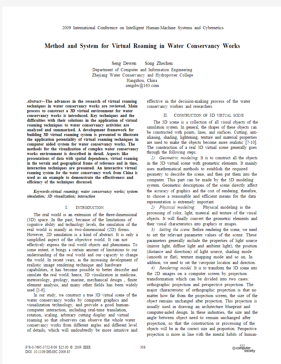
III.V IRTUAL ROAMING S YSTEM F RAMEWORK When the 3D virtual scene has been constructed by visualization technology, the system must provide a certain degree of human-computer interaction functions that enable users to better understanding and awareness of the objects in the scene, as well as the relationships between the objects. In all means of human-computer interaction, interactive roaming is the most important virtual observatory means. To this end, we design the system framework of a virtual roaming system as shown in Fig. 1.
Interaction of the rendering and displaying of the scene is all controlled by the user. The inputs of the user mainly refer to the keyboard and mouse input devices. They will be interpreted into a series of control commands for the management of scene’s data, the load of the geometric models, the settings of the objects’ illumination, material properties, transparency, as well as the viewpoint direction and location. The rendering module can render and display the scene dynamically and real-time based on the user’s input. In this process, the objects’ collision detection can be conducted according to the distance between the viewpoint and the objects [11-13].
IV.T HE IMPLEMENTATION OF VIRTUAL ROAMING
In the virtual roaming of water conservancy scene, the observer can use mouse or keyboard to control the location and direction of the viewpoint. When the location and direction of the viewpoint changed, the position and direction of the objects in the scene relative to the observer is also changed. In the virtual roaming system, the viewpoint is the "incarnation" of the human eyes. Its functions are similar to those of a camera in the real world. The essence of roaming process is to change the direction and location of the viewpoint; then a 3D animation in the virtual scene comes into being. Our study provides a simple controlling method to roam in the 3D scene using the keyboard. A.Process of keyboard command for virtual roaming
Keyboard roaming means the users navigate in the 3D scene through the manipulation of the keyboard. The users can roam and observe the scene flexibly and accurately. The course of roaming is to change location or direction of viewpoint in accordance with the keyboard commands and then render the scene. In general, keyboard roaming commands includes turning left and right, going forward and backward, going up and down, looking up and down, translating to left and right and so on. In our approach, we can calculate the new coordinates of the viewpoint and the reference point by decomposition computing of the space vector. For example, when in response to forward (backward) order, the viewpoint and reference point coordinates can be calculate using the following formula:
1)Viewpoint coordinates (speed stands for the moving speed, angz stands for the rotation angle of the sight line around the Z-axis)
vEyePt.x = vEyePt.x + (-) speed * sin (angz);
vEyePt.y = vEyePt.y + (-) speed * cos (angz);
vEyePt.z = vEyePt.z;
2)Reference point coordinates (updown_ang stands for the sight line with the XY plane or elevation angle) vLookAtPt.x = vEyePt.x +150 * sin (angz);
vLookAtPt.y = vEyePt.y +150 * cos (angz);
vLookAtPt.z = vEyePt.z +150 * sin (updown_ang);
The constant 150 is used to maintain a certain distance between the viewpoint and the reference point.
B.Record the roaming path
Roaming operation through the keyboard to achieve real-time 3D scene is flexible and convenient, but users continue to press the keyboard seemed to be somewhat cumbersome, especially when users need to repeat the previous process. To this end, the system designs a process to record the keyboard roaming functions (record the roaming path). The recorded keyboard roaming process is known as history record. The history roaming records can be re-broadcast to achieve the process of roaming [3].
The process to record keyboard roaming is as follows: First record the initial viewpoint, observation point, the rotation angle around Z-axis of the sight line, and the elevation, etc.; then for each kind of continuous keyboard command record them according to their "action type and operation number". The purpose is to explain the entire keyboard roaming process as roaming command sequences. Finally, execute the historical record commands contrary to the record process, i.e., read the initialization parameters from the document and set the system in accordance with these parameters, and then read the sequences of the keyboard commands and call the appropriate command handler for processing.
V.KEY TECHNIQUES
A.Realistic Iimage Rendering Technology
To achieve a true 3D simulation of the water conservancy environment, including the natural phenomena such as the
Figure 1. The system framework of virtual scene.
terrain, water system, plants, canals, etc. and the real man-made buildings, we need to use realistic image rendering technology including anti-aliasing, shading, illumination, shadow, material texture, blending and atomization techniques [14-16]. Photorealistic rendering directly affects the authenticity and visual effects of the scene, however, the realistic rendering and real-time rendering is two issues against each other. In many cases, we should strike a balance between them [17-18].
B.Level of Detail
It is an effective method to control the complexity of the scene by providing different levels of detail of the objects [9]. In the graphical display of complex scenes, when the objects farther and farther away from the viewpoint, the users can no longer distinguish many details of the structures of the objects; therefore, when drawing a distant object, it is totally unnecessary to describe the complex details of the object. It will waste resources and graphics processing time. Therefore, in order to improve the graphics rendering speed to meet the requirements of real-time rendering, 3D objects are generally rendered with a wide range of accuracy in accordance with the locations of observation point. When the locations of observation point changed, the system will choose different accuracy models to be drawn. This is the so-called level of detail (LOD) technology.
C.Collision Detection
Some objects in the 3D scene can be passed through, and some are not. For example, the buildings and mountains can not be passed through. When roaming, the objects that can not be passed through require collision detection. Collision detection is to detect the distance between the viewpoint and the object, and then restrict the location relationship of the viewpoint and the object when roaming. If the distance of the viewpoint and objects is less than a certain threshold, the collision occurred. At this time, the system need to give a reasonable response to the collision, for example, make the viewpoint backward a little, change the direction of the sight line, maintain a certain distance between the viewpoint and the object or pan left or right.
VI.C ONCLUSION
Based on the methods described above, the authors developed a 3D simulation system for water conservancy works. The methods efficiently facilitate the realization of the interactive virtual roaming in a true 3D virtual scene of water conservancy works. Through effective organization and management of the objects in the virtual 3D scenes of water conservancy works, the system increasingly improves the graphics rendering speed and the interactive response time. The users can roam interactively in the 3D virtual scene real-time by the keyboard commands. The virtual roaming is fast, fluent, real, and effective. Fig. 2 to 4 are the application of the methods and the system in the real data of a water conversancy work of China. They manifest the interactive process of users roaming in the true 3D virtual scene of a water conversancy work with a different location of viewpoint and different direction of sight line. Further research is under way, with the aim of integrating all the objects in the water conversancy works into the 3D virtual scene and providing more ways of interactive roaming.
Figure 2.
An aircraft simulates the user’ viewpoint and sight line
Figure 3.
Virtual roaming (trun right) in the 3D scenes
Figure 4. Virtual roaming (trun left) in the 3D scenes
A CKNOWLEDGMENT
The authors wish to thank the research foundation for doctoral programs of education ministry of China for
contract 20060008005, the foundation of science and technology department of Zhejiang province of China for contract 2006C33057, the foundation of water conservancy department of Zhejiang province of China for contract RC0847, and the foundation of education department of Zhejiang province of China for contract Y200805387, under which the present work was possible.
R EFERENCES
[1] D.W. Seng, X. Liang, "Visualization of large scale geographically
related data in virtual 3D scenes with OpenGL", In Wang C., Zhong S. & Wei J. (ed), Second international conference on space information technology; Proceedings of SPIE Bellingham, WA: SPIE, pp. 1027-1033, Nov, 2007.
[2] D. W. Seng, Z. X. Li, 3D visual modeling system for mineral
deposits. Journal of University of Science and Technology Beijing, pp. 453-456, May 2004.
[3] D. W. Seng, Z. X. Li, C. M. Li, Application of marching cubes
algorithm in visualization of mineral deposits, Journal of University of Science and Technology Beijing, pp. 203-207, Mar. 2005.
[4] C. Wang, W. Gao, X. Wang, Virtual Technology Theory,
Implementation and Application. Beijing: Tsinghua University Press, 1997.
[5]Z. Tang, Y. Sun, J. Deng, Advances in the Study of Visualization in
Scientific Computing. Journal of Tsinghua Unversity, vol. 41, pp.199-202, 2001.
[6] D. W. Seng, H.X. Wang, G.Y. Yue, 3D modeling and visualization of
complex geological structures using OpenGL. Boundaries of Rock Mechnics, Proceedings of the international young scholars’ symposium on rock mechanics, pp. 935-938, May 2008. [7] D. Seng, Z. Song, 3D interactive visualization system for cojmplex
geologically related data. First international conference on intelligent
networks and intelligent systems, pp. 519-522, Nov. 2008.
[8]J. Shang, X. Liu, K. Zheng, Research and Implementation of
Interactive Walkthrough in 3D Scene. Computer Engineering, vol. 29,
pp. 61-63, 2003.
[9]R. Wang, D. Zhang, C. Xin, The Research of 3D Graphics Building
Technology. Computer Aided Engineering, vol. 24, pp.25-30, Dec.
2000.
[10]X. Duan, Virtual Reality and Its Application in Geography. Scientia
Geographica Sinica, vol. 22, No.5, pp. 592-598. Oct. 2002.
[11] D. W. Seng, Z. X. Li, C. M. Li, Volume rendering techniques for
visualization of mineral deposits. Journal of Liaoning Technical University, vol. 24, pp.473-476, June 2005.
[12] C. Upson, M. Keeler, The V-Buffer: Visible Volume Rendering.
Computer Graphics, vol. 22, No. 4, pp.59-64, July 1990.
[13]L., Westover, Footprint Evaluation of Volume Rendering. Computer
Graphics, vol. 24, pp.367-376, Aug. 1990.
[14]W. E., Lorensen, H. E. Cline, Marching Cubes: A High Resolution
3D Surface Construction Algorithm. Computer Graphics, vol. 21, pp.
163-169, July 1987.
[15]T.S. Newman, J.B. Byrd, High performance SIMD marching cubes
isosurface extraction on commodity computers. Computers & Graphics, vol. 28, pp.213-233, May 2004.
[16] D. A. Rajon, W. E. Bolch, Marching cube algorithm: review and
trilinear interpolation adaptation for image-based dosimetric models.
Computerized Medical Imaging and Graphics, vol. 27, pp.411-435,
May 2003.
[17]R. Marschallinger, Three-dimensional reconstruction and
visualization of geological materials with IDL- examples and source
code. Computers & Geosciences, vol. 27, pp. 419-426, June 2001. [18]J. Dollner, K. Hinrichs, An object-oriented approach for integrating
3D visualization systems and GIS. Computers & Geosciences, vol.
26, pp.67-76, May 2000.
水利工程管理试题和参考答案
水利工程管理---参考答案 作业一 第一章概论 一、思考题(9分) 1、水利工程管理的基本任务是什么? 答:水利工程管理单位的任务是:安全运用水利工程,合理利用水资源,充分发挥水利工程防洪、供水、发电、航运、养鱼等综合效益;充分利用所占用人力、物力、财力,以及水域、土地资源,开展多种经营,为发展国民经济,提高人民生活水平和精神文明建设全面服务。并在发挥经济效益的同时,讲究自身的经营效益,实现自我维持简单再生产。 2、水利工程管理单位的特点是什么? 答:(1)生产活动的不稳定性;(2)产品流通范围的局限性;(3)生产资料的高度安全性要求;(4)生产活动具有确定性关系。 3、如何理解3S技术在水利工程管理中的应用? 答:信息技术正在加速向水利行业渗透,地理信息系统(GIS)、全球定位系统(GPS)、遥感(RS)等技术(简称3S技术)目前已用于防洪减灾、水灾旱情评估、水土流失监测、水资源规划、农业节水等诸多方面。虽然水利行业应用3S技术技术起步较晚些时候,但是发展势头很猛,成效显著。 二、填空题( 6.5分) 1、水工建筑物按其用途可分一般性水工建筑物和专门性水工建筑物。 2、水工建筑物按其使用时间可分为永久性建筑物和临时性建筑物。 3、水利工程按其规模可分为大(1)、大(2)、中型、小(1)型、小组(2)型等指标。 4、水利工程管理单位的经营管理基本内容包括生产力的合理组织、有关生产关系的正确处理两个方面。 5、3S技术是指地理信息系统、全球定位系统、遥感等技术。 三、问答题(15分) 1、简述水利工程管理的意义。 答:加强经营管理,建立并完善维持简单再生产的经营管理机制,发已成水利工程防洪、供水、发电效益,对于实现水利基础闪业的地位和作用,促进国民经济的发展,具有极为重要的意义。 2、水工建筑物的特点有哪些? 答:水工建筑物的特点主要有以下几点: 工作条件复杂;施工条件困难;失事的后果严重 3、水利工程管理的主要内容是什么?答:管理制度的确定和机构的建立;计划管理;生产技术管理;成本管理;多种经营管理;财务管理;考核评比 4、中国治水的新思路是什么? 答:必须向现代水利、可持续发展水利转变。强调对水资源管理要用全面的、系统的、综合的方法进行整体研究分析。 5、可应用于各种水利工程的一般性建筑物有哪些? 答:(1)挡水建筑物(2)泄水建筑物(3)取水建筑物(4)输水建筑物(5)整治建筑物(6)其它。第二章、水库的控制运用管理 一、填空题(8分) 1、径流调节分为兴利调节和防洪调节两大类。 2、兴利库容是指正常畜水位和死水位之间的库容。 3、水库防洪运用控制指标有允许最高水位、防洪运用标准和防洪限制水位。 4、水库防洪控制泄流方式可分为固定泄流、变动泄流和错峰泄流三种方式。 5、水库兴利运用指标有汛末蓄水位和兴利下限水位。 6、水库淤积的剖面形态可分为三角洲淤积、带状淤积和锥形淤积三种基本类型。
三维虚拟校园漫游系统设计
Scientific Journal of Information Engineering June 2013, Volume 3, Issue 3, PP.50-55 Design of 3D Virtual Campus Roaming System Hongyan Yang, Zhuo Shi, Yanru Zhong# College of Computer science and engineer, Guilin University of Electronic Technology, Guilin Guangxi 541004, China #Email: rosezhong@https://www.360docs.net/doc/a09420975.html, Abstract With the growing sophistication of virtual reality technology, 3D virtual campus roaming system as effective platform for school propaganda outside, the campus planning and management decision will provide a strongly support. Taking the campus of Guilin University of Electronic Technology as prototype, combing with the software of 3Ds Max and using VR-Platorm development platform connections with the backend database and virtual building and live Imaging shooting, a real-time roaming system of virtual campus has been designed and implemented. In this paper, the main aim is to explore a new idea for digital campus construction. Keywords: Virtual Reality; VR-Platform; Digital Campus 三维虚拟校园漫游系统设计* 杨宏艳,史卓,钟艳如 桂林电子科技大学计算机科学与工程学院,广西桂林 541004 摘要:随着虚拟技术的日益成熟,三维虚拟校园漫游系统作为学校对外宣传的有效平台是数字化校园建设的核心。以桂林电子科技大学东校区为例,结合三维仿真技术3DS max实现了虚拟校园的三维模型。运用VR-Platorm开发引擎,结合SQL Server数据库连接设计并实现了三维虚拟校园漫游系统。实现了自主漫游、按目的地自动生成漫游路径、定位鸟瞰等功能。实验结果表明:经过改进的场景优化技术,系统在普通PC机上运行稳定、流畅、高效。 关键词:虚拟现实;VR-Platform;数字校园 引言 20世纪80年代美国人Jaron Lanier首次正式提出了虚拟现实[1](Virtual Reality)概念。自此,这种利用计算机模拟虚拟世界,提供用户身临其境的视觉、听觉、触觉的感官模拟技术,因其具有感知性、沉浸性、交互性和构想性的特点,如今已广泛应用于城市规划、文物保护、交通模拟、虚拟现实游戏及远程教育等领域。“虚拟校园”是随因特网、虚拟现实技术、网络虚拟小区等的发展而产生,是基于现实校园对三维景观和教学环境数字化模拟的产物。数字化校园虚拟漫游系统是数字校园建设计划的核心平台。当前浙大率先开发展示了虚拟校园之后,国内众多高校如清华、南京大学、北航、香港中文大学等高等院校纷纷建立自己的虚拟校园[2-3] 。 通常,三维虚拟校园开发的主要方法是用ArcGis,SuperMap和其它具有三维功能的软件进行二次开发。但这些方法明显的缺点是对开发者的编程水平要求较高,建模代码太长,开发系统不能独立于运行环境。考虑到以上情况,本文选择VR-Platform为开发环境,提出了一种简单实现虚拟校园的方法。这种方法一方面能利用专业的建模工具3DS MAX软件很快实现三维场景模型的建立。另一方面,通过运用VRP引擎高效的模块化的编程能力,能够进行实时渲染和交互控制,减少了建模时间加速了系统开发的进程。另 *本文受国家自然科学基金(NO.50865003)和广西科学制造系统和先进制造技术开放基金资助(No.K090014)以及新世纪广西高等教育教改工程项目(No. 2011JGB048)“以工程应用能力为导向的数字媒体技术人才培养模式的探索与实践”基金资助。
三维全景虚拟漫游技术
一、意义 三维全景虚拟漫游技术的核心是通过计算机产生一种如同“身临其境”的具有动态、声 像功能的三维空间环境,而且使操作者能够进入该环境,直接观测和参与该环境中事物的变 化与相互作用。因此,将三维全景虚拟漫游技术应用于航天仿真研究,不但可以使得该领域 内的计算机仿真方法得到完善与发展,而且也将大大提高设计与试验的逼真性、实效性和经 济性,具体表现在如下几个方面: 1.人-机界面具有三维立体感,人融于系统,人机浑然一体。以座舱仪表布局为例,原 则上应把最重要且经常查看的仪表放在仪表板中心区域,次重要的仪表放在中心区域以外的 地方。这样能减少航天员的眼动次数,降低负荷,同时也让其注意力落在重要仪表上。但究 竟哪块仪表放在哪个精确的位置,以及相对距离是否合适,只有通过实验确定。因此利用 R 作 为工具设计出相应具有立体感、逼真性高的排列组合方案,再逐个进行试验,使被试处于其中,仿佛置身于真实的载人航天器座舱仪表板面前,就能达到理想客观的实验效果。 2.继承了现有计算机仿真技术的优点,具有高度的灵活性。因为它仅需通过修改软件中 视景图像有关参数的设置,就可模拟现实世界中物理参数的改变,这样,随着任务的变化, 已有的软件再经修改即可满意新任务的要求,所以十分灵活、方便。 3.突破环境限制。现有航天仿真的计算机系统体现不了空间失重环境,而建立三维全景 虚拟漫游系统,通过虚拟的景象和声响就可以使被试处于太空飞行中实际的载人航天器座舱中,据此展开的相应试验研究具有实际意义。 4.节省研究经费。改用真实的航天器进行相应的试验研究是不可能实现的,因为耗资巨大,经费条件不允许。而采用三维全景虚拟游技术,由于其研制周期较短,设计修改和改型 仅通过软件修改实现,可重复使用,设备损耗低,这样可大大节省经费投入。 二、研究现状 1965年,美国麻省理工学院的科学家设计了一种头盔显示器,通过传感器和计算机仿真 环境的相互作用,可以感觉到自己在几何图形中的移动,产生身临其境的感触感染,由此诞 生了一种新的仿真手段三维全景虚拟游技术。但由于其研制的头盔显示器性能较差,价格昂贵,很长时间内该项技术得不到应用。随着计算机图形学的发展,80年代中期,美国艾姆斯 航天研究中心利用流行的液晶显示电视和其它设备开始研究低成本的三维全景虚拟游系统, 这对于三维全景虚拟漫游技术的软、硬件研制发展推动很大。到了90年代,该项技术受到广 泛关注并向实用迈进。例如美国马歇尔空间飞行中心研制载人航天器的 R座舱,指导座舱布 局设计并训练航天员熟悉航天器的舱内布局、界面和位置关系,演练飞行程序。目前,美国 各大航天中心已广泛地应用 R技术开展相应领域内的研究工作。在 R技术传入我国后,除几 所院校建立一些初步的 R系统模型外,尚无在航天仿真领域展开此项技术的应用研究。 一般而言,三维全景虚拟漫游系统具有两大特点:可以从数据空间向外观察和被试可以 沉醉到数据空间中。它是通过对研究对象的模型进行计算机仿真,由计算机结果去控制虚拟 一
(整理)人机交互课程设计---VRML设计--虚拟校园漫游系统.
《人机交互》综合设计报告 设计名称:人机交互综合设计 选题名称:VRML设计--虚拟校园漫游系统 姓名学号: 专业班级: 系(院): 设计时间: 指导教师评语: 成绩: 签名: 年月日
目录 一、概述 (3) 1、项目背景 (3) 2、系统简介: (3) 3、开发环境: (3) 4、主要技术 (3) 二、需求分析 (4) 1、用户分析 (4) 2、用户设计流程 (4) 3、任务分析 (4) 三、设计 (5) 1、界面设计原则 (5) 2、设计模型 (5) 3、系统描述 (6) 4、使用的交互技术 (6) 四、界面实现 (6) 五、主要源码设计 (7) 六、可用性评估 (8) 1、评估指标体系 (9) 2、具体步骤 (9) 3、结果分析 (10) 七、结论 (10) 1、总结.......................................................................................................................... 错误!未定义书签。10 2、不足之处 (10) 3、心得体会 (10)
一、概述 1、项目背景 VRML是一种建模语言,也是一种描述Internet上交互式3D多媒体和共享虚拟世界的开放标准。 VRML定义了一组用以描述三维图形的对象,这些对象称为节点,节点被组织成一种分层的结构,称为场景。使用场景图数据结构来建立3D场境。场景图是一种代表所有3D世界静态特征的节点等级:几何关系、质材、纹理、几何转换、光线、视点以及嵌套结构。境界中的对象及其属性用节点描述,节点按照一定规则构成场景图,也就是说,场景图是境界的内部表示。场景图中的第一类节点用于从视觉和听觉角度表现对象,它们按照层次体系组织起来,反映了境界的空间结构。另一类节点参与事件产生和路由机制,形成路由图,确定境界随时间的推移如何动态变化。 VRML用文本信息来描述三维场景,在Internet上传输,然后在本地机上由VRML 浏览器解释生成三维场景。这种工作机制,避免了在网络上直接传输图形文件,把复杂任务交给本地机器,从而减轻了网络的负担,使得在Internet上的三维交互成为可能。 VRML的访问方式是基于客户/服务器模式,其中服务器提供VRML文件及支持资源,客户通过网络下载希望访问的文件,并通过本地平台上的VRML浏览器交互式访问该文件描述的虚拟境界,因为浏览器是本地平台提供的,从而实现了与硬件平台的无关性。 现今,基于VRML的虚拟校园漫游系统已经有很多成功案例,如成都电子科技大学、义乌工商学院等,都已成功开发出了虚拟校园漫游系统。 2、软件定义: 基于VRML的虚拟校园漫游系统 3、系统简介: 通过VRML制作的虚拟校园是个规模较大的三维场景,旨在通过网络展示校园风貌,用户可以走入虚拟校园中,观赏校园的自然风貌,领赂校园的生活氛围。浏览者可以利用输入设备控制自己的视点和视角,对这个虚拟场景进行全方位的浏览和交互。 4、开发环境: 3DMax,NetScape浏览器
水利工程管理与信息化建设
水利工程管理与信息化建设 发表时间:2019-08-27T11:35:52.533Z 来源:《工程管理前沿》2019年第12期作者:汪锐 [导读] 对水利工程管理与信息化建设进行了深入的分析。 霍邱县排灌管理总站齐王站安徽六安 237400 摘要:随着我国经济以及科技的不断发展,我国信息化技术的发展速度也随之提高,在社会各行各业中都有信息化的影子,信息化应用的范围非常广泛,前景十分可观。水利工程是与我国人民生活有非常密切联系的一项基础工程,其质量直接关系到我国人民的生活质量以及生命财产的安全,优质的水利工程会带动当地的经济发展,因此,做好水利工程的管理工作十分重要。在信息化时代进行信息化建设不但是社会发展的必然要求,同时也是水利工程发展的必然趋势,这篇文章就针对水利工程管理与信息化建设进行了深入的分析。 关键词:水利工程;管理;信息化;建设 引言 在我国经济建设中非常重要的一项工程就包括水利工程,随着我国社会的不断发展进步,人们对于这项工程相关的管理也提出了更高的要求,最近几年,对于水利工程管理的方式或者模式有了更加深入的探索,但是在这一过程中,由于受到多种因素的影响,水利工程管理的水平并没有获得大幅度的提高,管理模式也没有很大的改观。随着信息化时代的到来,在水利工程中也在不断的运用信息化技术,进行水利工程信息化建设,有助于实现水利资源共享以及水利工程智能化管理,还有助于实现水利管理决策时效性,更大程度上保障各种数据信息实时性。实现水利工程信息化建设需要进行多方面的努力。 一、水利工程管理中存在的问题 (一)在质量方面存在问题 水利工程的质量直接影响着其最终的使用效果。因此,水利工程管理中最重要的任务就是确保其质量符合相关标准,但是现阶段我国众多的水利工程管理当中都存在不同程度的问题。最为显著的问题就是水利工程企业内部没有完善的管理制度,企业内部缺乏完善的管理制度会导致管理工作的质量受到影响,最终影响整个水利工程的质量。还有一个较为显著的问题就是相关的政府部门的监管力度不到位,通过调查我们发现,大部分企业所涉及的水利工程项目都非常多,政府在监管方面不够持久,而且监管也不够严格,没有严格的监管力度很容易导致水利工程出现一些安全隐患。很多企业在实际的施工过程当中为了争取招标,会采用一些错误的方式,例如向其他企业借用工作人员,政府在监管之后将相关的工作人员进行替换,以此来通过招标,这种错误的方式会严重影响施工人员的整体水平[1]。在水利工程竣工之后,政府部门也要进行监管,但是由于相关监管部门工作不够严谨,对于工程验收的监管效果也很难很大程度的发挥出来,因此,对于工程中出现的一些不合格的施工材料等问题也很难发现,水利工程的质量难以保证,甚至还会威胁人们的生命财产安全。 (二)在成本方面存在问题 做好成本预算工作是保障水利工程顺利实施的关键,但是做好成本控制工作并不意味着一味的降低成本,成本控制工作要能够充分确保工程的质量,不能只考虑降低成本,总之要进行全方面的考虑。随着市场经济的不断发展,做好水利工程成本控制工作变得越来越重要,但同时这项工作也面临很多的挑战。随着社会的不断发展,水利工程的市场招标竞争越来越激烈,企业招标面临很大的风险,同时在费用控制方面也有了更大的难度[2]。另外,很多企业也没有统一的评估标准,评估的方式也不具有创新性,成本控制相关的工作人员,由于其专业知识有限,在进行成本控制的过程中还会出现资金或者资源浪费的情况。 (三)在安全方面存在问题 施工安全问题贯穿于整个水利工程的始终,如果不够重视安全问题会带来很多的安全隐患,很多的水利工程企业往往不具备完善的安全管理体系,相关的工作人员责任制也没有全面落实[3],另外,很多的企业对于安全管理方面的资金投入力度不够,导致缺乏专业的安全管理人员,这难以实现安全管理。 二、水利工程管理问题的解决对策 (一)加强监管 1.提高相关工作人员的责任意识 相关的工作人员是否具有足够的安全意识,直接影响到工作的质量,企业要结合发展的实际情况向相关的工作人员讲解不合格的水利工程带来的不良后果,让相关的工作人员能够从思想上意识到本职工作的重要性,在实际的工作过程中就能够实现严格的把关。 2.严格管理相关技术 水利工程的施工技术对于整个工程的发展有着很大的影响,因此,严格管理相关技术非常重要,通过严格管理相关技术,能够有效保障整个工程的质量,通过控制相关的技术,能够从根本上杜绝不合格施工队伍的出现,充分保障工程的质量[4]。 3.充分落实责任制 充分落实监管工作人员相关的责任是保障监管工作顺利进行的重要途径,对于水利工程监管而言,其采用的是终身责任制,所以要严格落实各个工作人员的责任,这样才能够保障在出现问题之后有效的追究责任。 (二)做好安全管理工作 1.充分落实安全管理制度 只有充分落实安全管理制度,才能够保障安全管理工作的顺利进行,企业要事先制定好安全管理制度,同时更要落实好现场安全管理工作,确保所实施的施工方案是安全有保障的。对于施工中一些安全系数较高的项目更要加强管理。 2.注重各个环节的安全 水利工程施工过程涉及多个环节,每个环节都至关重要,不同的环节有着不同的施工要点,所以在施行安全管理的时候也要运用不同的管理方式,对于材料的安全管理要进一步强化,成品的管理亦同样如此。 (三)做好成本控制工作 成本控制工作要从实际粗暴,在确保工程质量的前提下,更大程度的节约成本,要采用符合标准的施工材料,避免出现资金的浪费,这样才能够节约成本。
虚拟校园漫游系统的设计与开发
学院 : 信息与电子工程学院 专业 : 教育技术学___ 班级 : __ A2_____ 学号 : ___ 学生姓名: _____ 指导教师: _____ 论文题目:虚拟校园漫游系统的设计与开发
承诺书 我谨在此郑重承诺: 本毕业设计(论文)是本人在指导老师指导下,独立撰写完成的。凡涉及他人观点和材料,均依著作规范作了注释。如有抄袭或其他违反知识产权的情况,我愿接受学校处分。 承诺人(签名):
摘要 虚拟校园是基于地理信息技术、虚拟现实技术和计算机网络技术等高新技术,将校园地理信息和其他校园信息相结合,以虚拟现实场景界面实现校园景观及信息的浏览查询,并可上载到计算机网络和提供远程用户访问。虚拟校园提供了校园景观及设施最直观的表现形式,方便了用户对校园信息的访问,促进了大学的建设和远程教学的发展。建立简单易行的现实感强的虚拟校园漫游便成为对大学校园虚拟化的目标。而VRML和3D MAX等相关软件也为虚拟校园提供了技术上的支持。 本文的研究目的是设计并开发一个虚拟校园漫游系统,作者通过阅读大量国内外相关文献资料,深入地研究了虚拟现实技术和现有构造三维场景的语言,在此基础上,确定了基于VRML及浏览器插件技术的虚拟现实系统架构方案。 首先,以虚拟场景构造的流程为线索,采用3Dstudio Max和VRMLPad实现虚拟场景对象的建模;针对建筑物建模的复杂度和真实感问题,提出了建筑物二次建模方法; 其次,探讨了虚拟校园场景的交互。在此基础上实现了视点控制和动画交互。 第三,在系统设计开发的末尾阶段,讨论对虚拟校园漫游系统的优化方法。通过碰撞检测、层次细节技术、纹理映射等技术方法优化系统。 除此之外,还探讨了系统的整体构架、系统的开发流程、模型纹理贴图以及纹理贴图对场景外观的巨大作用。最后综合以上研究工作,设计并实现了一个基于VRML技术的虚拟校园系统。 关键词:虚拟校园、虚拟现实(VR)、漫游、建模、纹理贴图、交互设计
基于三维全景技术的动态虚拟漫游系统
基于三维全景技术的动态虚拟漫游系统 摘要针对当前全景漫游系统存在的问题,自主研发一种基于三维全景技术的动态虚拟漫游系统。该系统利用先进的网络、数据库技术,提出一系列改进算法,建立动态数据模块,并对数据流程图中的各个模块进行描述;利用HTML5框架上开源的WebGL库文件,构建Ajax模式下的MVC设计模型;借助SqlServer 数据库,增加后台管理平台,从而能对本系统不断更新、维护。 关键词全景漫游;动态数据模块;MVC设计模型;SqlServer数据库 近年来,虚拟现实技术一直是计算机应用领域的研究热点,其特点是利用计算机多媒体技术系统中创建真实世界的仿真环境,通过计算机的硬件设备来模拟人体的视觉、听觉、味觉和触觉等真实感知,使参与者在其中产生与在真实环境中相同或相似的体验。根据人体的生理特点,在各种感知中视觉感知占80%,因此在虚拟现实技术的研究中,视觉的模拟占有十分重要的地位。 1 研究背景 基于视觉的虚拟现实技术主要分为两种:一种是基于三维几何模型建模技术(VRM),另一种是基于图像的全景绘制技术(IBR)。VRM在实时绘制时显然计算量大、制作周期长,再加上互联网网速的延迟,以及计算机本身硬件条件的限制,显得无能为力。IBR提供了较好的方法来解决这些难题,利用真实场景的图像作为虚拟场景的表示形式,真实地再现了真实场景的视觉信息,生成的场景视图的质量远远优于VRM。 目前,国内许多全景数字史馆建设往往采用特制的软件来实现,比较常用的国外软件有MGI photo suite、Pano2VR、Panorama Maker、Virtools、Ulead Cool 360等,国内也有一些比较好的全景处理软件,比如杰图的“造景师”、彩影以及中视典的vrp系列软件。 虽然直接使用商业软件能够比较简单、快速地制作出基于IBR的360全景,但是它们没有考虑现实情况中不断增长、实时更新的动态性问题。所以,本项目自主研发一种基于三维全景技术的动态虚拟漫游系统。 2 关键技术 全景漫游技术可以实现网络上的虚拟场景漫游,因其具有良好的交互性、沉浸性而受到众多用户的青睐。传统漫游技术如VRML、QuickTime、Flash等大多存在标准不一、插件依赖、封闭性、集成性差等问题,新兴的基于HTML5的全景漫游方案可以对以上问题进行缓解。 2.1 基于HTML5的全景漫游技术的实现原理
水务项目管理信息系统
铜仁市水务项目管理信息系统设计方案
铜仁市水务局 月年20164 目录 项目概况1 (3) 项目建设背景1.1 (3) 依据1.2 (3) 设计目标.1.3 (3) 技术优势1.4 (4) 软件设计开发方案 2 (5) 2.1总体设计方案 (5) 软件系统功能说明2.2 (6) 2.2.1基础数据查询系统 (6) 2.2.2项目管理信息系统 (7) 2.3数据库建设和存储系统 (12) 2.3.1数据库软件的功能要求及选型 (12) 2.3.2数据库设计原则 (12) 2.3.3数据库总体设计 (13) 2.3.4数据库部署 (14) 3系统建设部署环境及运行维护 (14) 3.1系统运行维护 (14) 系统部署环境设计3.2 (14) 3.2.1网络和主机设计要求 (14) 3.2.2机房等其他配套附属设施设计要求 (14) 3.2.3主要软硬件选型配置要求 (15) 4项目实施方案 (16) 4.1项目组结构 (16) 项目实施计划4.2 (17) 软件开发过程4.3 (17) 4.3.1软件需求分析 (17) 4.3.2结构设计 (18) 4.3.3详细设计 (18) -i-
4.3.4编码 (18) 4.3.5集成测试 (18) 4.3.6系统测试 (18) 4.3.7验收 (18) 4.3.8维护 (19) 5项目预算 (19)
-ii- 项目概况1 目建设背景项1.1 源配置资指导,以水观为铜仁市水务局以科学发展十二五期间, 工程、城乡供排水保障工程、农村水利工程、防洪减灾工程、水土保持 展需要的水利基发重点,基本形成经济社会工程及水生态修复工程为 护、水与保资源管理制度、水资源节约础设施体系。以实施最严格水 重点,加快形成适设为务体系建文明制度建设、基层水利水务服生态 资源保障有力、开极构建水代水利发展需要的制度体系。积应山区现
山东信息职业技术学院虚拟校园漫游系统
0引言 随着虚拟现实技术的不断发展和完善,在社会生活各个领域得到了极其广泛的应用,其中一个重要的应用就是大学校园。三维虚拟校园是展示校容校貌和校园信息化建设的重要组成部分,以三维虚拟现实场景呈现校园风光,并在此基础上增加了漫游功能,更加具体表现了虚拟校园真实性和沉浸性等特点,可以极大地方便学生、促进招生和网络办公。在国内许多高校都建设了自己的虚拟校园,如浙江大学、清华大学、南京大学、北京航空大学、华中科技大学等[1]。 目前,在虚拟校园的开发中,主要采用的方法有Virtools [2] 、VRML [3-4]、VEGA [5-6]等。基于这些技术开发的虚拟校园漫游 系统具有交互性和沉浸感,能够让参观者获得身临其境的感觉。但对于实际应用来说,光有漫游功能是不够的,对于虚拟校园场景中出现的建筑和艺术雕像,应该能为用户提供更加详细的介绍。 本文基于VRP 虚拟现实平台,实现了虚拟校园。不仅能让用户实现三维漫游,还介绍了如何联接数据库,使得用户在漫游中查询到选择物体的详细信息,更好地满足用户的需求。并以山东信息职业技术学院为例,详细介绍了系统的构建过程。 1开发步骤 山东信息职业技术学院虚拟校园系统开发方法可以分为如图一所示的六个步骤,分别是基础数据采集、虚拟校园场景建模、模型优化、导入VRP 、连接数据库和系统生成。 图一系统开发流程图 2前期工作 根据山东信息职业技术学院提供的信息,校园主要的建筑有旧教学楼、办公楼、新教学楼和餐厅等。然后,根据建筑搜集其建筑面积、高度以及用途等各种相关信息。再结合校园建筑平面图,我们能够完整地获得整个校园建筑物、绿地、公路等地物的地理坐标及平面轮廓形状,勾勒出整个校园场景。 对校园进行实地考察,用数码相机采集反映学校真实景观的建筑物、道路、树木等纹理图。为了减少数据量,贴图用 山东信息职业技术学院虚拟校园漫游系统 Virtual Campus Roaming System of Shandong Information Vocational and Technical College 王琰萍1,2邵丽丽1陈勇1Wang Yanping Shao Lili Chen Yong (1.中国海洋大学信息学院,山东青岛266100;2.山东信息职业技术学院,山东青岛266100)(1.College of Information Science and Engineering,Ocean University of China,Shandong Qingdao 266100; 2.Shandong Information Vocational and Technical College,Shandong Qingdao 266100) 摘要:本文以山东信息职业技术学院校园为例,将虚拟现实技术应用于校园。介绍了虚拟校园的构建过程,借助VRP 生成三维虚拟校园漫游系统,并实现了连接数据库功能,使得用户在漫游中查询到选择物体的详细信息,为用户提供更加详细的介绍。 关键词:虚拟现实;虚拟校园;信息查询中图分类号:TP391 文献标识码:A 文章编号:1671-4792-(2009)3-0121-04 Abstract :This paper introduces the process of constructing a virtual campus and based on VRP ,realized Virtual Campus Roaming System of Shandong Information Vocational and Technical College .In this demo ,we attached a database to the virtual object ,which allows users getting detailed information of objects when roam-ing ,and provides users introduction with more details . Keywords :Virtual Reality ;Virtual Campus ;Information Query 山 东信息职业技术学院虚拟校园漫游系统 121
基于krpano 的全景漫游系统的实现
Krpano功能介绍 Krpano的所有标签如下: Crop属性的四个值:0 、0、50、50,表示在加载的图片的0,0位置起,宽50高50裁切出一个图片,供当前使用。也就是说,可以把好几个图标整合在一张图片上,使用时,调用Crop脚本函数,提供要切割的起始坐标,要切割图片的宽高。 parent属性设置插件的父插件名称 Krpano viewer的功能是十分强大和复杂的.本文只介绍系统所用到的几个比较重要的标签=、校园全景漫游的具体实现 2.1、将krpano viewer嵌入html网页 Krpa~o Viewer提供了swfkrpano.is脚本使用它可以很方
便地将krpano viewer嵌入html网页.其使用方法如下: 首先引人脚本文件: