南美洲地理情况【英文】
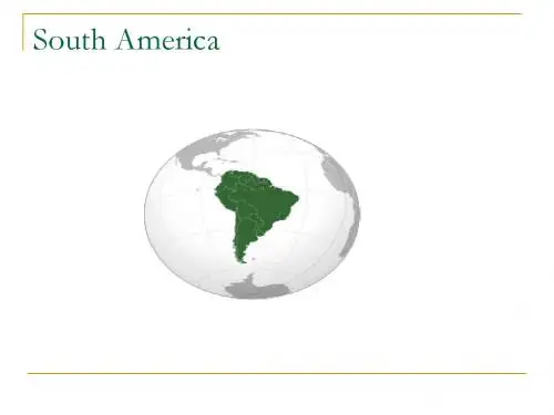
South America(南美洲)
San Alfonso del Mar. Luxury hotel located in Algarrobo (Chile) and contains the world's largest pool.
Brazilian Carnival
Carnival is the most famous holiday in Brazil and has become an event of huge proportions. The country stops completely for almost a week and festivities are intense, day and night, mainly in coastal cities. The consumption of beer accounts for 80% of annual consumption and tourism receives 70% of annual visitors. The government distributes condoms and launches awareness campaigns at this time to prevent the spread of AIDS.
Simón Bolí var, one of the main Independence movement leaders, Venezuelan military and political leader. Together with José de San Martí n, he played a key role in Latin America's successful struggle for independence from the Spanish Empire, and is today considered one of the most influential politicians in South American history.
四大洲七大洋的英语介绍

四大洲七大洋的英语介绍The four continents and seven oceans are:Continents:1. Asia: Asia is the largest continent in terms of both land area and population. It is located primarily in the Eastern Hemisphere and is bordered by the Pacific Ocean to the east, the Indian Ocean to the south, and the Arctic Ocean to the north. Asia is known for its diverse cultures, rich history, and breathtaking landscapes.亚洲:亚洲是面积和人口最多的大洲,主要位于东半球,东临太平洋,南临印度洋,北临北冰洋。
亚洲以其多样化的文化、丰富的历史和壮观的风景而闻名。
2. Africa: Africa is the second-largest continent and is located in the Eastern Hemisphere. It is surrounded by the Mediterranean Sea to the north, the Atlantic Ocean to the west, and the Indian Ocean to the southeast. Africa is known for its diverse wildlife, stunning landscapes, and unique cultures.非洲:非洲是第二大洲,位于东半球,北临地中海,西临大西洋,东南临印度洋。
非洲以其多样化的动植物、壮丽的风景和独特的文化而闻名。
南美洲地理
Rainforest Fun Facts • There are two types of rainforests the temperate and the tropical. Tropical rainforests are found close to the equator. Temperate rainforests are found along coasts of the United States. • Every second, 1 1/2 acres of land are lost every day because human are destroying and ruining them. • Every day, we are losing about 137 different types of plant, animal, and insect species. • A medicine man is somebody who believed to heal others by using supernatural powers, especially among Native American people. •
• The rain forest provide food, water, natural rubber, medicinal plants, and other products.
• Problems
– Soil exhaustion (soil has lost the nutrients) – Deforestation
Who else lives there now? • Conquistadors • Mestizos • Aborigines • Gringos (people from North America and Europe)
环球国家地理百科全书.南美洲、两极地区

高原上的
3 年轻首 都——巴 西利亚
南美洲第
4 一大城 市——圣 保罗
“第二首
5 都”—— 里约热内 卢
6 实力强大 的工业
South America 南美洲 湮没在雨林中的古老传奇
巴西 Brazil
以种植业为 主的农业
发展较快的 运输业
新兴的旅游 业
South America 南美洲 湮没在雨林中的古老传奇 巴拉圭 Paraguay
06
克丘亚人的 土妈妈节
01
冰川国家公 园
05
独特的民族 音乐和舞蹈
02
潘帕斯草原 的牧羊人
04
接近欧洲式 的生活习俗Leabharlann 03丰富的自然 资源
South America 南美洲 湮没在雨林中的古老传奇
阿根廷 Argentina
A
为独立而 进行的斗
争
B
较为发达 的经济
C
“美洲巴 黎”—— 布宜诺斯
艾利斯
科尔卡峡谷 神 鹰出没之地
库斯科 太阳的 子孙
的的喀喀湖 印 第安圣湖
马丘比丘 空中 之城
蒂亚瓦纳科 传 说与想象的遗迹
美文 找寻地理中的美
01 潘塔纳尔湿地 奇珍 02 亚马孙雨林 地球之
异兽的水上乐园
肺
03 伊瓜苏瀑布 彩虹常 04 莫雷诺冰川 冰川时
现之地
代的标本
05 巴塔哥尼亚荒原 沉 06 巴里洛切 南美小瑞
址
South America 南美洲 湮没在雨林中的古老传奇 巴西 Brazil
0 1
耶稣山
0 4
巴西狂欢节
0 2
丰富的动植物 资源
0 5
沙滩阳光浴
南美国家地理系列之巴西热带雨林探秘_中英对照版
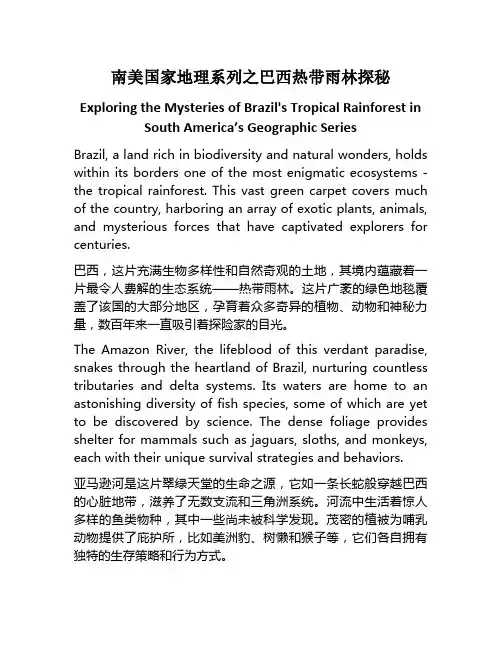
南美国家地理系列之巴西热带雨林探秘Exploring the Mysteries of Brazil's Tropical Rainforest in South America’s Geographic SeriesBrazil, a land rich in biodiversity and natural wonders, holds within its borders one of the most enigmatic ecosystems - the tropical rainforest. This vast green carpet covers much of the country, harboring an array of exotic plants, animals, and mysterious forces that have captivated explorers for centuries.巴西,这片充满生物多样性和自然奇观的土地,其境内蕴藏着一片最令人费解的生态系统——热带雨林。
这片广袤的绿色地毯覆盖了该国的大部分地区,孕育着众多奇异的植物、动物和神秘力量,数百年来一直吸引着探险家的目光。
The Amazon River, the lifeblood of this verdant paradise, snakes through the heartland of Brazil, nurturing countless tributaries and delta systems. Its waters are home to an astonishing diversity of fish species, some of which are yet to be discovered by science. The dense foliage provides shelter for mammals such as jaguars, sloths, and monkeys, each with their unique survival strategies and behaviors.亚马逊河是这片翠绿天堂的生命之源,它如一条长蛇般穿越巴西的心脏地带,滋养了无数支流和三角洲系统。
环球地理(南美洲——巴西)

第八小组
——巴西
南美洲的介绍——附加
南美洲是南亚美利加洲的简称,位于西半球南部,东面是大西洋, 西为太平洋。陆地以巴拿马运河为界与北美洲相分,南面隔海与 南极洲相望。总面积1797七平方公里(含附近岛屿),占世界陆 地总面积的12%,按面积大小排是丂大洲中的第四个。南美洲海 岸线长28700公里。海岸较为平直,少岛屿和海湾。
巴西(Brazil),全称巴西联邦共和国,是南美洲最大的国家,享有 “足球王国”的美誉。国土总面积为851.49万平方公里,居世界第五。 总人口2.01亿。与乌拉圭、阿根廷、巴拉圭、玻利维亚、秘鲁、哥伦 比亚、委内瑞拉、圭亚那、苏里南、法属圭亚那十国接壤。 历史上巴西曾为葡萄牙的殖民地,1822年9月7日宣布独立。巴西的 官方语言为葡萄牙语。国名源于巴西红木。 巴西拥有丰富的自然资源和完整的工业基础,国内生产总值位居南 美洲第一,为世界第七大经济体。是金砖国家之一,也是南美洲国 家联盟成员。是里约集团创始国之一,南方共同市场、20国集团成 员国,不结盟运动观察员。全球发展最快的国家之一,是重要的发 展中国家之一。 巴西的文化具有多重民族的特性,巴西作为一个民族大融炉,有来 自欧洲、非洲、亚洲等地区的移民。足球是巴西人文化生活的主流 运动,是2014年世界杯举办国。
South America
Page 8
Most areas in summer the hottest average temperature between 26.8 DEG C, far from Africa and the continent of Australia 's tropical regions with hot. The annual range of temperature around the smaller South America, Asia, North America is not as dramatic changes. The entire island of abundant precipitation, annual precipitation in 1000 mm above the area about the size of the entire island more than 70%, for the Delta in the desert area of the smaller island. The influence on the west side of the Andes is temperate maritime climate, the east side is a temperate continental climate.
简介 The introduction 南美洲是南亚美利加洲的简称,总面积1797万平方 公里(含附近岛屿),占世界陆地总面积的12%。南 美洲海岸线长28700公里。海岸较为平直,少岛屿和 海湾。
Page 5
人口:401,000,000。人口分布不平衡,西北部和东部沿 海一带人口稠密,广大的亚马孙平原是世界人口密度最小 的地区之一,每平方千米不到一人。人口分布的另一特点 是人口 南美洲高度集中在少数大城市。 民族:南美洲民族成分比较复杂,有印第安人、白人、黑 人及各种不同的混血型,以印欧混血型最多。白人最多, 其次是印欧混血型和印第安人,黑人最少。 语言:印第安人用印第安语,巴西的官方语言为葡萄牙语, 法属圭亚那官方语言为法语,圭亚那官方语言为英语,苏 里南官方语言为荷兰语,其它国家均以西班牙语为官方语 言。 宗教:居民绝大多数信天主教,少数信基督教。
南美洲、大洋洲各国及首都中英文(带音标)
['pæpjuə]['ɡini]
莫尔兹比港
Port Moresby
['mɔ:zbi]
4
所罗门群岛
Solomon Islands
['sɔləmən]
霍尼亚拉
Honiara
[͵həʊnɪ`ɑ:rə]
5
瓦努阿图共和国
Republic ofVanuatu
[͵vɑ:nu:`ɑ:tu:]
['bwenəs'aiəriz]
11
乌拉圭东岸共和国
Oriental Republic of Uruguay
['uruɡwai]
蒙得维的亚
Montevideo
[͵mɔntivi'deiəu]
12
巴西联邦共和国
Federative Republic of Brazil
[brə'zil]
巴西利亚
Brasilia
[ɡai'ɑ:nə,ɡai'ænə]
乔治敦
Georgetown
['dӡɔ:dӡtaun]
4
苏里南共和国
Republic of Suriname
[,suərɪ`nɑ:mə]
帕拉马里博
Paramaribo
[͵pærə`mærɪbəʊ]
5
厄瓜多尔共和国
Republic of Ecuador
[͵ekwə'dɔ:]
圣地亚哥
Santiago
[sænti'ɑ:ɡəu]
9
巴拉圭共和国
Republic of Paraguay
['pærəɡwai]
国家地区介绍-5-南美洲
新埃斯帕塔州 Nueva Esparta
VE-S
VE-T VE-X VE-U VE-V VE-W VE-A
联邦属地
联邦区
---
---
南美洲国家
---委内瑞拉
南美洲国家
---委内瑞拉
委内瑞拉货币 委内瑞拉所使用的货币称为玻利瓦尔。 2008年1月1日起开始,委内瑞拉实行了货币改革,发
行新货币强势玻利瓦尔(bolí var fuerte),强势玻利瓦尔 (VEF) 。 强势玻利瓦尔与玻利瓦尔的兑换比率是1:1000 。 现流通的面值有2、5、10、20、50、100六种。
ISO 3166-2代码
VE-Z VE-B VE-C VE-D
安索阿特吉州 Anzoátegui
阿普雷州
阿拉瓜州 巴里纳斯州 玻利瓦尔州 卡拉沃沃州 科赫德斯州
Apure
Aragua Barinas Bolivar Carabobo Cojedes
VE-E
VE-F VE-G VE-H VE-Y VE-I VE-J VE-K VE-L VE-M VE-N VE-O VE-P VE-R
南美洲国家
---南美洲各国总览
ቤተ መጻሕፍቲ ባይዱ哥伦比亚 厄瓜多尔 乌拉圭
委内瑞拉 秘鲁 巴拉圭
圭亚那 玻利维亚 巴西
法属圭亚那 智利
苏里南 阿根廷
南美洲国家
---哥伦比亚
中文名称 英文名称
哥伦比亚共和国 The Republic of Colombia
国土面积 国际电话区号
1,141,748平方公里 +57
简称
南美洲国家
---委内瑞拉
委内瑞拉全国的一级
州名中译
关于南美洲地形的作文英语
关于南美洲地形的作文英语South America, the fourth largest continent, is a land of striking contrasts and diverse topography. From the soaring peaks of the Andes to the vast expanses of the Amazon rainforest, the continent's landscape is a testament to the power of nature and its ability to shape the world around us.The Andes, a mountain range that runs the length of the western coast of South America, is one of the mostsignificant geographical features on the continent. Stretching over 7,000 kilometers, the Andes is home to Aconcagua, the highest peak outside of Asia, which stands at an impressive 6,960 meters above sea level. The range not only serves as a natural barrier but also plays a crucialrole in the climate and water supply of the region.Moving eastward from the Andes, one encounters the Amazon Basin, which covers a staggering 40% of South America's total area. The Amazon rainforest, often referred to as the "lungs of the Earth," is the largest tropical rainforest on the planet. It is a biodiversity hotspot, hosting an estimated 400 billion individual trees and more than 16,000 species of plants. The Amazon is also home to a rich array of wildlife, including jaguars, sloths, and countless species of birds, insects, and reptiles.South America's topography also includes the vast grasslands of the Pampas in Argentina, which are essential foragriculture and livestock. The Gran Chaco, a semi-arid region that spans across Argentina, Paraguay, and Bolivia, is another significant feature, known for its unique flora and fauna.The continent's northern edge is lined with a series of deserts, such as the Atacama in Chile, which is one of the driest places on Earth. In contrast, the southern tip of South America boasts the stunning glacial landscapes of Patagonia, where the Perito Moreno Glacier is a popular attraction for tourists and adventurers alike.The Orinoco River basin in the north and the Paraná River system in the south are vital water sources that support a variety of ecosystems and human settlements. These river systems are not only geographical features but also lifelines for the people and wildlife that depend on them.In conclusion, South America's topography is a complex and varied landscape that has been shaped by millions of years of geological activity. From the towering Andes to the lush Amazon, the continent's geography is as diverse as its cultures and peoples. Understanding the topography of South America is essential for appreciating the natural beauty and ecological importance of this remarkable continent.。
- 1、下载文档前请自行甄别文档内容的完整性,平台不提供额外的编辑、内容补充、找答案等附加服务。
- 2、"仅部分预览"的文档,不可在线预览部分如存在完整性等问题,可反馈申请退款(可完整预览的文档不适用该条件!)。
- 3、如文档侵犯您的权益,请联系客服反馈,我们会尽快为您处理(人工客服工作时间:9:00-18:30)。
Pampas-Grassland
The Pampas are located in the center of the northern part of Argentina.
Just below Buenos Aires Average temperature is 18°c Dry season is summer (December)
The Pampas are a fertile plain.
Bodies of
Water
Parana River
south Central South America, running through Brazil, Paraguay and Argentina
Ombu is tree like plant home to a number of rodents, many unique to the
region, from grasslands to sparse vegetation.
Waterfowl and waders make their home in cool rivers or coastal lagoons.
In Chile, it rises to over
20,000 feet.
range is also known for io civilizations
Desert
Patagonia Desert
Covers nearly all of the southern portion of mainland Argentina.
Guiana Highlands
plateau and low-mountain region of South America located north of the Amazon and south of the
Orinoco River. Comprising a heavily forested plateau, they cover the
Brazilian Highlands
central and southeastern Brazil. Rising to an average elevation of 3,300 feet above sea
level characterized by low mountains, hilly uplands, and
Andes Mountains
Andes stretch 4,000 miles from the north to the south, thus making it the longest mountain range in the world.
The mountain range spans seven countries — Venezuela, Colombia, Ecuador, Peru, Bolivia, Chile and Argentina
tabular plateaus and include Mato Grosso Plateau and ParanáPlateau. geologically similar to the Guiana Highlands to the north, across the eastern Amazon River basin.
Much of the desert extends up into the Andes mountains and is very high in elevation.
Many times this area will go without rainfall at all for years. Some places in the Atacama Desert have not had rainfall for over 400 years.
southern half of Venezuela, all of the Guianas except for the low Atlantic coastal plain, the northern part of Brazil, and a portion of southeastern Colombia. whole region receives an abundance of rainfall, and no season is really dry.
https:///matthewlawhead/sout h-america-intro-ppt
Geography
South America is the fourth largest continent in size and the fifth largest in population. It is located primarily in the southern hemisphere, is bordered by the Atlantic Ocean to the east and the Pacific Ocean to the West. The geography of South America is dominated by the Andes Mountain Range and the Amazon River (second longest river in the world).
The largest desert in Argentina and is the 5th largest desert in the world by area
Atacama Desert
The Atacama desert is found along the coast of Chile, South America