Unit 1 Nautical Publications Lesson 3 Admiralty Notices to Mariners 英版航海通告
船舶实用导航文集(英文)Nautical Publicati
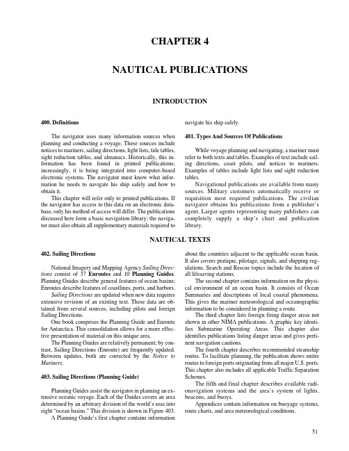
CHAPTER 4 NAUTICAL PUBLICATIONSINTRODUCTION400. DefinitionsThe navigator uses many information sources when planning and conducting a voyage.These sources include notices to mariners,sailing directions,light lists,tide tables, sight reduction tables,and almanacs.Historically,this in-formation has been found in printed publications; increasingly,it is being integrated into computer-based electronic systems.The navigator must know what infor-mation he needs to navigate his ship safely and how to obtain it.This chapter will refer only to printed publications.If the navigator has access to this data on an electronic data-base,only his method of access will differ.The publications discussed here form a basic navigation library;the naviga-tor must also obtain all supplementary materials required to navigate his ship safely.401. Types And Sources Of PublicationsWhile voyage planning and navigating,a mariner must refer to both texts and tables.Examples of text include sail-ing directions,coast pilots,and notices to mariners. Examples of tables include light lists and sight reduction tables.Navigational publications are available from many itary customers automatically receive or requisition most required publications.The civilian navigator obtains his publications from a publisher’s rger agents representing many publishers can completely supply a ship’s chart and publication library.NAUTICAL TEXTS402. Sailing DirectionsNational Imagery and Mapping Agency Sailing Direc-tions consist of37Enroutes and10Planning Guides. Planning Guides describe general features of ocean basins; Enroutes describe features of coastlines,ports,and harbors.Sailing Directions are updated when new data requires extensive revision of an existing text.These data are ob-tained from several sources,including pilots and foreign Sailing Directions.One book comprises the Planning Guide and Enroute for Antarctica.This consolidation allows for a more effec-tive presentation of material on this unique area.The Planning Guides are relatively permanent;by con-trast,Sailing Directions(Enroute)are frequently updated. Between updates,both are corrected by the Notice to Mariners.403. Sailing Directions (Planning Guide)Planning Guides assist the navigator in planning an ex-tensive oceanic voyage.Each of the Guides covers an area determined by an arbitrary division of the world’s seas into eight“ocean basins.”This division is shown in Figure403.A Planning Guide’s first chapter contains information about the countries adjacent to the applicable ocean basin. It also covers pratique,pilotage,signals,and shipping reg-ulations.Search and Rescue topics include the location of all lifesaving stations.The second chapter contains information on the physi-cal environment of an ocean basin.It consists of Ocean Summaries and descriptions of local coastal phenomena. This gives the mariner meteorological and oceanographic information to be considered in planning a route.The third chapter lists foreign firing danger areas not shown in other NIMA publications.A graphic key identi-fies Submarine Operating Areas.This chapter also identifies publications listing danger areas and gives perti-nent navigation cautions.The fourth chapter describes recommended steamship routes.To facilitate planning,the publication shows entire routes to foreign ports originating from all major U.S.ports. This chapter also includes all applicable Traffic Separation Schemes.The fifth and final chapter describes available radi-onavigation systems and the area’s system of lights, beacons, and buoys.Appendices contain information on buoyage systems, route charts, and area meteorological conditions.5152NAUTICAL PUBLICATIONS404. Sailing Directions (Enroute)Each volume of the Sailing Directions(Enroute) contains numbered sections along a coast or through a strait.Figure404a illustrates this division.Each sector is discussed in turn.A preface with detailed information about authorities,references,and conventions used in each book precedes the sector discussions.Finally,each book provides conversions between feet,fathoms,and meters.The Chart Information Graphic,the first item in each chapter,is a graphic key for charts pertaining to a sector. See Figure404b.The graduation of the border scale of the chartlet enables navigators to identify the largest scale chart for a location and to find a feature listed in the Index-Gaz-etteer.These graphics are not maintained by Notice to Mariners;one should refer to the chart catalog for updated chart listings.Other graphics may contain special information on lo-cal winds and weather,anchorages,significant coastal features, and navigation dangers.A foreign terms glossary,an appendix of anchorages, and a comprehensive Index-Gazetteer follow the sector dis-cussions.The Index-Gazetteer is an alphabetical listing of described and charted features.The Index lists each feature by geographic coordinates and sector number for use with the graphic key.Features mentioned in the text are listed by page number.405. Coast PilotsThe National Ocean Service publishes nine United States Coast Pilots to supplement nautical charts of U.S. rmation comes from field inspections,survey vessels,and various harbor authorities.Maritime officials and pilotage associations provide additional information. Coast Pilots provide more detailed information than Sailing Directions because Sailing Directions are intended exclu-sively for the oceangoing mariner.The Notice to Mariners updates Coast Pilots.Each volume contains comprehensive sections on local operational considerations and navigation regulations.Follow-ing chapters contain detailed discussions of coastal navigation. An appendix provides information on obtaining additional weather information,communications services,and other da-ta. An index and additional tables complete the volume.406. Other Nautical TextsThe government publishes several other nautical texts. The Defense Mapping Agency,for example,publishes the Maneuvering Board Manual(Pub.217),The Radar Navi-gation Manual(Pub.1310)and the American Practical Navigator(Pub. 9).The U.S.Coast Guard publishes navigation rules for international and inland waters.This publication,officially known as Commandant Instruction M16672.2b,contains Figure 403. The 8 ocean basins as organized for Sailing Directions (Planning Guides).NAUTICAL PUBLICATIONS53Figure 404a. Sector Limits graphic.Additional chart coverage may be found in CATP2 Catalog of Nautical Charts.Figure 404b. Chart Information graphic.54NAUTICAL PUBLICATIONSthe Inland Navigation Rules enacted in December1980 and effective on all inland waters of the United States in-cluding the Great Lakes,as well as the International Regulations for the Prevention of Collisions at Sea,enact-ed in1972(1972COLREGS).Mariners should ensure that they have the updated issue.The Coast Guard also publishes comprehensive user’s manuals for the Omega, Loran,and GPS navigation systems;Navigation and Ves-sel Inspection Circulars;and the Chemical Data Guide for Bulk Shipment by Water.The Government Printing Office provides several pub-lications on navigation,safety at sea,communications,weather,and related topics.Additionally,it publishes pro-visions of the Code of Federal Regulations(CFR)relating to maritime matters.A number of private publishers also provide maritime publications.The International Maritime Organization,International Hydrographic Organization,and other governing interna-tional organizations provide information on international navigation regulations.Chapter1gives these organiza-tions’addresses.Regulations for various Vessel Traffic Services(VTS),canals,lock systems,and other regulated waterways are published by the authorities which operate them.USING THE LIGHT LISTS407. Light ListsThe United States publishes two different light lists. The U.S.Coast Guard publishes the Light List for lights in U.S.territorial waters;DMAHTC publishes the List of Lights for lights in foreign waters.Light lists furnish complete information about naviga-tion lights and other navigation aids.They supplement,but do not replace,charts and sailing directions.Consult the chart for the location and light characteristics of all naviga-tion aids;consult the light lists to determine their detailed description.The Notice to Mariners corrects both lists.Corrections which have accumulated since the print date are included in the Notice to Mariners as a Summary of Corrections.All of these summary corrections,and any corrections published sub-sequently, should be noted in the “Record of Corrections.”A navigator needs to know both the identity of a light and when he can expect to see it;he often plans the ship’s track to pass within a light’s range.If lights are not sighted when predicted,the vessel may be significantly off course and standing into danger.A circle with a radius equal to the visible range of the light usually defines the area in which a light can be seen. On some bearings,however,obstructions may reduce the range.In this case,the obstructed arc might differ with height of eye and distance.Also,lights of different colors may be seen at different distances.Consider these facts both when identifying a light and predicting the range at which it can be seen.Atmospheric conditions have a major effect on a light’s range.Fog,haze,dust,smoke,or precipitation can obscure a light.Additionally,a light can be extinguished. Always report an extinguished light so maritime authorities can issue a warning.On a dark,clear night,the visual range is limited by ei-ther:(1)luminous intensity,or(2)curvature of the earth. Regardless of the height of eye,one cannot see a weak light beyond a certain luminous range.Assuming light travels lin-early,an observer located below the light’s visible horizon cannot see it.The Distance to the Horizon table gives the distance to the horizon for various heights of eye.The light lists contain a condensed version of this table.Abnormal re-fraction patterns might change this range;therefore,one cannot exactly predict the range at which a light will be seen.408. Determining Range And Bearing Of A Light At Initial SightingA light’s luminous range is the maximum range at which an observer can see a light under existing visibility conditions.This luminous range ignores the elevation of the light,the observer’s height of eye,the curvature of the earth,and interference from background lighting.It is de-termined from the known nominal range and the existing visibility conditions.The nominal range is the maximum distance at which a light can be seen in weather conditions where visibility is 10 nautical miles.The U.S.Coast Guard Light List usually lists a light’s nominal e the Luminous Range Diagram shown in the Light List and Figure408a to convert this nominal range to luminous range.Remember that the luminous ranges ob-tained are approximate because of atmospheric or background lighting conditions.Estimate the meteorological visibility by the Meteorological Optical Range Table,Figure 408b.Next,enter the Luminous Range Diagram with the nominal range on the horizontal nominal range scale.Follow a vertical line until it intersects the curve or reaches the re-gion on the diagram representing the meteorological visibility.Finally,follow a horizontal line from this point or region until it intersects the vertical luminous range scale.Example1:The nominal range of a light as extracted from the Light List is 15 nautical miles.Required:The luminous range when the meteorologi-cal visibility is(1)11nautical miles and(2)1nautical mile.Solution:To find the luminous range when the meteo-NAUTICAL PUBLICATIONS55rological visibility is11nautical miles,enter theLuminous Range Diagram with nominal range15nautical miles on the horizontal nominal rangescale;follow a vertical line upward until it inter-sects the curve on the diagram representing ameteorological visibility of11nautical miles;from this point follow a horizontal line to the rightuntil it intersects the vertical luminous range scaleat16nautical miles.A similar procedure is fol-lowed to find the luminous range when themeteorological visibility is 1 nautical mile.Answers:(1) 16 nautical miles; (2) 3 nautical miles.A light’s geographic range depends upon the height of both the light and the observer.Sum the observer’s distance to the horizon based on his height of eye and the light’s distance to the horizon based on its height to calculate a light’s geo-graphic range.See Figure408c.This illustration uses a light 150feet above the water.Table12,Distance of the Horizon, yields a value of14.3nautical miles for a height of150feet. Within this range,the light,if powerful enough and atmo-spheric conditions permit,is visible regardless of the height of eye of the observer.Beyond14.3nautical miles,the geo-graphic range depends upon the observer’s height of eye. Thus,by the Distance of the Horizon table mentioned above, an observer with height of eye of5feet can see the light on his horizon if he is2.6miles beyond the horizon of the light.The geographic range of the light is therefore16.9miles.For a height of30feet the distance is14.3+6.4=20.7miles.If the height of eye is70feet,the geographic range is14.3+9.8= 24.1miles.A height of eye of15feet is often assumed when tabulating lights’ geographic ranges.Figure 408a. Luminous Range Diagram.56NAUTICAL PUBLICATIONSTo predict the bearing and range at which a vessel will ini-tially sight a light first determine the light’s geographic pare the geographic range with the light’s luminous range.The lesser of the two ranges is the range at which the light will first be sighted.Plot a visibility arc centered on the light and with a radius equal to the lesser of the geographic or luminous ranges.Extend the vessel’s track until it intersectsthe visibility arc.The bearing from the intersection point to the light is the light’s predicted bearing at first sighting.If the extended track crosses the visibility arc at a small angle,a small lateral track error may result in large bearing and time prediction errors.This is particularly ap-parent if the vessel is farther from the light than predicted;the vessel may pass the light without sighting it.However,not sighting a light when predicted does not always indi-cate the vessel is farther from the light than expected.It could also mean that atmospheric conditions are affecting visibility.Example 2:The nominal range of a navigational light120feet above the chart datum is 20nautical miles.The meteorological visibility is 27nautical miles.Required:The distance at which an observer at aheight of eye of 50 feet can expect to see the light.Solution:The maximum range at which the lightmay be seen is the lesser of the luminous or geo-graphic ranges.At 120feet the distance to the horizon,by table or formula,is 12.8miles.Add 8.3miles,the distance to the horizon for a height of eye of 50feet to determine the geo-graphic range.The geographic range,21.1miles,is less than the luminous range,40miles.Answer:21nautical miles.Because of various uncer-tainties,the range is rounded off to the nearest whole mile.CodeNo.YardsWeather0Dense fog . . . . . . . . . . . . . . . . . . .Less than 501Thick fog . . . . . . . . . . . . . . . . . . .50-2002Moderate fog . . . . . . . . . . . . . . . .200-5003Light fog . . . . . . . . . . . . . . . . . . .500-1000Nautical Miles4Thin fog . . . . . . . . . . . . . . . . . . . .1/2-15Haze . . . . . . . . . . . . . . . . . . . . . . .1-26Light Haze . . . . . . . . . . . . . . . . . .2-5 1/27Clear. . . . . . . . . . . . . . . . . . . . . . . 5 1/2-118Very Clear . . . . . . . . . . . . . . . . . .11.0-27.0.9Exceptionally Clear . . . . . . . . . . .Over 27.0From the International Visibility Code.Figure 408b. Meteorlogical Optical Range Table.Figure 408c. Geographic Range of a light.NAUTICAL PUBLICATIONS57When first sighting a light,an observer can determine if it is on the horizon by immediately reducing his height of eye.If the light disappears and then reappears when the ob-server returns to his original height,the light is on the horizon. This process is called bobbing a light.If a vessel has considerable vertical motion due to rough seas,a light sighted on the horizon may alternately appear and disappear.Wave tops may also obstruct the light periodically.This may cause the characteristic to appear different than expected.The light’s true characteristics can be observed either by closing the range to the light or by the observer’s increasing his height of eye.If a light’s range given in a foreign publication ap-proximates the light’s geographic range for a15-foot observer’s height of eye,assume that the printed range is the light’s geographic range.Also assume that publication has listed the lesser of the geographic and nominal ranges. Therefore,if the light’s listed range approximates the geo-graphic range for an observer with a height of eye of15 feet,then assume that the light’s limiting range is the geo-graphic range.Then,calculate the light’s true geographic range using the actual observer’s height of eye,not the as-sumed height of eye of15feet.This calculated true geographic range is the range at which the light will first be sighted.Example3:The range of a light as printed on a foreign chart is17miles.The light is120feet above chart da-tum.The meteorological visibility is10nautical miles.Required:The distance at which an observer at a height of eye of 50 feet can expect to see the light.Solution:Calculate the geographic range of the light assuming a15foot observer’s height of eye.At120feet the distance to the horizon is12.8miles.Add4.5miles(the distance to the horizon at aheight of15feet)to12.8miles;this range is17.3miles.This approximates the range listed on thechart.Then assuming that the charted range is thegeographic range for a15-foot observer height ofeye and that the nominal range is the greater thanthis charted range,the predicted range is found bycalculating the true geographic range with a50foot height of eye for the observer.Answer:The predicted range=12.8mi.+8.3mi.=21.1mi..The distance in excess of the chartedrange depends on the luminous intensity of thelight and the meteorological visibility.409. USCG Light ListsThe U.S.Coast Guard Light List(7volumes)gives in-formation on lighted navigation aids,unlighted buoys, radiobeacons,radio direction finder calibration stations, daybeacons, racons, and Loran stations.Each volume of the Light List contains aids to naviga-tion in geographic order from north to south along the Atlantic coast,from east to west along the Gulf coast,and from south to north along the Pacific coast.It lists seacoast aids first,followed by entrance and harbor aids listed from seaward.Intracoastal Waterway aids are listed last in geo-graphic order in the direction from New Jersey to Florida to the Texas/Mexico border.The listings are preceded by a description of the aids to navigation system in the United States,luminous range di-agram, geographic range tables, and other information.410. NIMA List of Lights, Radio Aids, and Fog SignalsThe National Imagery and Mapping Agency publishes the List of Lights,Radio Aids,and Fog Signals(usually re-ferred to as the List of Lights,not to be confused with the Coast Guard’s Light List).In addition to information on lighted aids to navigation and sound signals in foreign wa-ters,the NIMA List of Lights provides information on storm signals,signal stations,racons,radiobeacons,and radio di-rection finder calibration stations located at or near lights. For more details on radio navigational aids,consult Pub. 117, Radio Navigational Aids.The NIMA List of Lights does not include information on lighted buoys inside harbors.It does include certain aeronautical lights situated near the coast;however,these lights are not designed for marine navigation and are sub-ject to unreported changes.Foreign notices to mariners are the main correction-al information source for the NIMA Lists of Lights;other sources,such as ship reports,are also used.Many aids to navigation in less developed countries may not be well maintained.They are subject to damage by storms and vandalism, and repairs may be delayed for long periods.MISCELLANEOUS NAUTICAL PUBLICATIONS411. NIMA Radio Navigational Aids (Pub. 117) This publication is a selected list of worldwide ra-dio stations which perform services to the mariner. Topics covered include radio direction finder and radar stations,radio time signals,radio navigation warnings,distress and safety communications,medical advice via radio,long-range navigation aids,the AMVER system, and interim procedures for U.S.vessels in the event of an outbreak of hostilities.Pub.117is corrected via the Notice to Mariners and is updated periodically with a new edition.58NAUTICAL PUBLICATIONSThough Pub.117is essentially a list of radio sta-tions providing vital maritime communication and navigation services,it also contains information which explains the capabilities and limitations of the various systems.412.Chart No. 1Chart No.1is not actually a chart but a book contain-ing a key to chart symbols.Most countries which produce charts also produce such a list.The U.S.Chart No.1con-tains a listing of chart symbols in four categories:•Chart symbols used by the National Ocean Service •Chart symbols used by the Defense MappingAgency•Chart symbols recommended by the InternationalHydrographic Organization•Chart symbols used on foreign charts reproduced byNIMASubjects covered include general features of charts,to-pography,hydrography,and aids to navigation.There is also a complete index of abbreviations and an explanation of the IALA buoyage system.413. NIMA World Port Index (Pub. 150)The World Port Index contains a tabular listing of thou-sands of ports throughout the world,describing their locations,characteristics,facilities,and services available. Information is arranged geographically;the index is ar-ranged alphabetically.Coded information is presented in columns and rows.This information supplements information in the Sailing Directions.The applicable volume of Sailing Di-rections and the number of the harbor chart are given in the World Port Index.The Notice to Mariners corrects this book.414. NIMA Distances Between Ports (Pub. 151) This publication lists the distances between major ports.Reciprocal distances between two ports may differ due to different routes chosen because of currents and cli-matic conditions.To reduce the number of listings needed, junction points along major routes are used to consolidate routes converging from different directions.This book can be most effectively used for voyage planning in conjunction with the proper volume(s)of the Sailing Directions(Planning Guide).It is corrected via the Notice to Mariners.415. NIMA International Code Of Signals (Pub. 102) This book lists the signals to be employed by vessels at sea to communicate a variety of information relating to safety,distress,medical,and operational information.This publication became effective in 1969.According to this code,each signal has a unique and complete meaning.The signals can be transmitted via Mor-se light and sound,flag,radio-telegraphy and-telephony, and semaphore.Since these methods of signaling are inter-nationally recognized,differences in language between sender and receiver are immaterial;the message will be un-derstood when decoded in the language of the receiver, regardless of the language of the sender.The Notice to Mar-iners corrects Pub. 102.416. AlmanacsFor celestial sight reduction,the navigator needs an al-manac for ephemeris data.The Nautical Almanac, produced jointly by H.M.Nautical Almanac Office and the U.S.Naval Observatory,is the most common almanac used for celestial navigation.It also contains information on sun-rise,sunset,moonrise,and moonset,as well as compact sight reduction tables.The Nautical Almanac is published annually.The Air Almanac contains slightly less accurate ephemeris data for air navigation.It can be used for marine navigation if slightly reduced accuracy is acceptable.Chapter19provides more detailed information on us-ing the Nautical Almanac.417. Sight Reduction TablesWithout a calculator or computer programmed for sight reduction,the navigator needs sight reduction tables to solve the celestial triangle.Two different sets of tables are commonly used at sea.Sight Reduction Tables for Marine Navigation,Pub. 229,consists of six volumes of tables designed for use with the Nautical Almanac for solution of the celestial triangle by the Marcq Saint Hilaire or intercept method.The tab-ular data are the solutions of the navigational triangle of which two sides and the included angle are known and it is necessary to find the third side and adjacent angle.Each volume of Pub.229includes two8degree zones, comprising15degree bands from0to90degrees,with a1°degree overlap between volumes.Pub.229is a joint publi-cation produced by the National Imagery and Mapping Agency,the U.S.Naval Observatory,and the Royal Green-wich Observatory.Sight Reduction Tables for Air Navigation,Pub.249,is also a joint production of the three organizations above.It is issued in three volumes.Volume1contains the values of the altitude and true azimuth of seven selected stars chosen toNAUTICAL PUBLICATIONS59provide,for any given position and time,the best observa-tions.A new edition is issued every5years for the upcoming astronomical epoch.Volumes2(0°to40°)and3(39°to 89°) provide for sights of the sun, moon, and planets.418. CatalogsA chart catalog is a valuable reference to the navigator for voyage planning,inventory control,and ordering.There are two major types of catalogs,one for the military and one for the civilian market.The military navigator will see the NIMA nautical chart catalog as part of a larger suite of catalogs includ-ing aeronautical(Part1),hydrographic(Part2),and topographic(Part3)products.Each Part consists of one or more volumes.Unclassified NIMA nautical charts are listed in Part2,Volume1.This is available only to U.S. military users,DoD contractors,and those who support them.This catalog contains comprehensive ordering instruc-tions and information about the products listed.Also listed are addresses of all Combat Support Center field offices,in-formation on crisis support,and other special situations.The catalog is organized by geographic region corresponding to the chart regions1through9.A special section of miscella-neous charts and publications is included.This section also lists products produced by NOS,the U.S.Army Corps of Engineers,U.S.Coast Guard,U.S.Naval Oceanographic Office,and some foreign publications from the United Kingdom and Canada.The civilian navigator should refer to catalogs produced by the National Ocean Service.For U.S.waters,NOS charts are listed in a series of single sheet“charts”showing a major region of the U.S.with individual chart graphics shown. These catalogs also list charts showing titles and scales.Fi-nally,it lists sales agents from whom the products may be purchased.NIMA products for the civilian navigator are listed by NOS in a series of regionalized catalogs similar to Part2 Volume1.These catalogs are also available through autho-rized NOS chart agents.MARITIME SAFETY INFORMATION419.Notice To MarinersThe Notice to Mariners is published weekly by the Defense Mapping Agency Hydrographic/Topographic Center(DMAHTC),prepared jointly with the National Ocean Service(NOS)and the U.S.Coast Guard.It advises mariners of important matters affecting navigational safe-ty,including new hydrographic information,changes in channels and aids to navigation,and other important data. The information in the Notice to Mariners is formatted to simplify the correction of paper charts,sailing directions, light lists,and other publications produced by NIMA, NOS, and the U.S. Coast Guard.It is the responsibility of users to decide which of their charts and publications require correction.Suitable records of Notice to Mariners should be maintained to facilitate the updating of charts and publications prior to use.Information for the Notice to Mariners is contributed by:the Defense Mapping Agency Hydrographic/Topo-graphic Center(Department of Defense)for waters outside the territorial limits of the United States;National Ocean Service(National Oceanic and Atmospheric Ad-ministration,Department of Commerce),which is charged with surveying and charting the coasts and har-bors of the United States and its territories;the U.S.Coast Guard(Department of Transportation)which is responsi-ble for the safety of life at sea and the establishment and operation of aids to navigation;and the Army Corps of Engineers(Department of Defense),which is charged with the improvement of rivers and harbors of the United States.In addition,important contributions are made by foreign hydrographic offices and cooperating observers of all nationalities.Over60countries which produce nautical charts also produce a notice to mariners.About one third of these are weekly,another third are bi-monthly or monthly,and the rest irregularly issued according to need.Much of the data in the U.S.Notice to Mariners is obtained from these for-eign notices.Correct U.S.charts with the U.S.Notice to Mariners. Similarly,correct foreign charts using the foreign notice because chart datums often vary according to region and geographic positions are not the same for different datums.The Notice consists of a page of Hydrograms list-ing important items in the notice,a chart correction section organized by ascending chart number,a publica-tions correction section,and a summary of broadcast navigation warnings and miscellaneous information.Mariners are requested to cooperate in the correction of charts and publications by reporting all discrepancies be-tween published information and conditions actually observed and by recommending appropriate improvements.A convenient reporting form is provided in the back of each Notice to Mariners.Notice to Mariners No.1of each year contains impor-tant information on a variety of subjects which supplements information not usually found on charts and in navigational publications.This information is published as Special No-tice to Mariners Paragraphs.Additional items considered。
航海英语1

Unit 01 Nautical PublicationsI Admiralty List of Lights and Fog SignalsThe latest known details of lights, light-structures, light-vessel, light-float, lanbys and fog signals are given in Admiralty List of Lights and Fog Signals (ALL), usually termed “Admiralty List of Lights”. Light-buoys of a height of 8 m or greater may also be listed and some with a height of less than 8 m are occasionally include in the list, as are light-buoys considered to be of primary navigational significance. Certain minor lights, in little frequented parts of the world covered only by small scale charts, are included in the list thought they are not charted.最新的有关灯标的详细资料,灯塔,灯船,灯浮,大型的导航浮标(蓝比)和雾号在英版灯标雾号表中已经登记,这常被称为“英版灯标”。
8米或更高的灯浮都会全部登记,而且一些高度不足8米的灯浮有些也会登记,灯浮同样被认为是航海上基本的重要物。
某些次要的灯,小比例尺海图只有世界的小区域,都在名单内但是不会绘制在图上。
A Geographical range table for determining dipping distances, and a luminous range diagram for obtaining the range at which a light can be seen allowing for its power and the prevailing visibility, are contained in each volume.地理能见距离决定了灯标的初显初隐距离,光标的光达距离图解的距离允许在盛行的能见度中被看到,那些图解在每一册中都有出现。
船舶安全检查清单

LIST OF SHIP SAFETY INSPECTION 船舶安全检查清单. _____________________________ IMO Number________________________ Official Number______________________DOCUMENTATION 证书Statutory Certificates 法定证书Note: Not Applicable如有任何船级社条件证书请说明Documents and Plans to be posted up onboardManuals, Booklets and Record BookPORT STATE CONTROL INSPECTION RECORD 港口国检查记录〔Please fill in the recent one years’ PSC inspection record〕请填写最近一年的检查detainable items raised 在上一个港口国检查出的缺陷中有无过期未纠正的遗留缺陷或出现了滞留项目_____________________________________________________________________________________________________________________________________________________________________________________________________________________________________________________________________________________________________________________________________________________________________________________________________________________________________________________________________________________________________________________________________________________________________________________________________________________________________________________________________________________________________________________________________________________________________________________________________________________________________________________________________________________________________________________________________________________________________________________________________________________________________________________________________________________________________________________________________________________________________________________________________________________________________________________________________________________________________________________________________________________________________________________________________________________________________________________________________________________________________________________________________________________________________________________________IMO & OTHER MARITIME RELATED PUBLICATIONSPUBLICATIONS PEQUIRED TO BE CARRIED ONBOARD A HONG KONG REGISTERED SHIPINTERNATIONAL SAFETY MANAGEMENT (ISM)CODE ISM规则To assess the effectiveness of the Safety Management System (SMS), please see “Explanatory notes to surveyors” for items marked with )NAVIGATIONAL EQUIPMENT 航海仪器LOAD LINE AND STRUCTURAL CONSTRUCTION 载重线和结构PREVENTION OF POLLUTION 防污染MACHINERY ITEMS 机械项目ELECTRICAL ITEMS 电气项目GMDSS RADIO INSTALLATION GMDSS 无线电设备CREW ACCOMMODATION, HEALTH, WELFARE & MISC. 船员生活区、健康、福利及其它SOLAS RELATED OPERATIONAL REQUIREMENTS FOR DRILLSOverall Grading for Various AspectsD – Poor(差)E – Very Poor(非常差)。
美英报刊阅读教程Lesson 3 课文
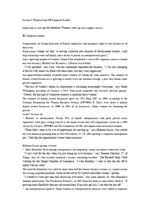
Lesson 3 Women Leap Off Corporate LadderMany turn to start-ups for freedom1 Women’s start-ups have higher successBy Stephanie ArmouCorporations are losing thousands of female employees and managers eager to start businesses of their own.Professional women say they’ re leaving corporate jobs because of advancement barriers, scant help balancing work and family, and a desire to pursue an entrepreneurial goal.2Like a growing number of women, JoAnn Corn abandoned a successful corporate career to launch her own business, Health Care Resources, a Denver-based firm3.“I was petrified,” says Corn, who has continually expanded her business. “1 was just champing at the bit.4 My mind was filled with these ideas, but they were suppressed.”An unprecedented number of professional women are taking the same initiative. The number of female-owned businesses is growing at nearly twice the national average, a pace that alarms some private employers.“The loss of women’s talents in corporations is becoming increasingly worrisome,” says Sheila Wellington, president of Catalyst, a New York-based nonprofit and research advisory group5. “Clearly, the message to Corporate America is maintain these women.”The number of female-owned businesses grew by 78% from 1987 to 1996, according to the National Foundation for Women Business Owners (NFWBO) 6. There were about 8 million female-owned businesses in 1996, or 36% of all businesses. Many women are shunning the privatesector7 because of:•Barriers to advancement. Nearly 30% of female entrepreneurs with prior private-sector experience cited glass-ceiling issues8 as the major reason they left corporations, based on a 1998 survey by Catalyst, NFWBO and The Committee of 200, and organization of businesswomen. “There didn’t seem to be a lot of opportunity for moving up,” says Diahann Lassus, who started her own financial planning firm in New Providence, N. J.9, after quitting a corporate management job. “I felt like the opportunities weren’t there anymore.”Diahann Lassus giving a lecture•More flexibility. Even though entrepreneurs toil long hours, many can choose when they work. “I can’t wait for the day when I’m just doing my own business,” says Tammie Chestnut, 27, of Tempe, Ariz.10, who recently launched a resume consulting busi ness”, The Resum6 Shop, while working for the Tempe Chamber of Commerce. “I want freedom. 1 want to take the day off to spend with my child.”The need for flexibility was cited by more than half the female business owners as a major reason for leaving corp orate positions, based on the survey by Catalyst and other women’ s groups.“I wanted to work part time and choose my own hours,” says Aura Ahuvia, 33, who launched a monthly publication, The Washtenaw Parent12, in 1995 from her home in Ann Arbor, Mich13. “It gave me more flexibility than any job around here. If my kids get sick, I can take the day off.”•An entrepreneurial spark14. Many women say entrepreneurial interests were stifled at corporatejobs.“As you get larger, it’s really a struggle to think outside the box15,” says Lois Haber, CEO of Delaware V alley Financial Services in Berwyn, Pa.16, which uses a focus group to foster creativity. “You just want to get the work done.”Female-owned firms generate about $2.3 trillion in revenue, a 236% jump from 1987 to 1996. Female business owners employ about 18.5 million people, which means one out of every four company workers in the USA is at a female-owned firm. “The rise in women entrepreneurs is one of the big demographics changing our society,” says Ly nn Neeley, president-elect of the United States Association for Small Business and Entrepreneurship.Female entrepreneursAnd it’s an issue causing mounting concern for private employers trying to hold onto top hires17. Deloitte & Touche, for example, started programs such as flexible work arrangements to help stanch turnover. Others are taking advantage of the disillusionment: McDonald’s ads woo franchisees with the slogan “Golden Arches, not glass ceilings.”18“Women starting businesses today compared to 20 years ago are more likely to leave because they’re frustrated,” says Julie Weeks, research director at NFWBO. “Those are the kind of employees companies would love to keep.”But going solo is no guarantee of success.19 Women report they struggle to be taken seriously. Hours can be grueling. Failure rates are high.While start-ups often have a shaky future, there is promise. Female-owned businesses are more likely to remain in operation than the average firm. The fastest growth today among female-owned firms includes manufacturing, construction, whole-sale distribution and agribusiness.“They see an opportunity to make a difference and become involved,” says Sharon Hadary, executive director of NFWBO. “Not only do we have more women-owned business, the businesses we have are more sophisticated and larger. The businesses themselves are becoming more substantial.”The Small Business Administration reports that nearly three-fourths of female-owned firms launched in 1991 were still operating three years later, vs. two-thirds of all companies.“The biggest obstacle is they’re not taken seriously,” says Phyllis Hill Slater, president of the National Association of Women Business Owners. “I tell women, ‘The more money you earn the more seriously you’ 11 be taken.’ ”Worth the riskMany women feel it’ s worth the gamble. Just last month, Geraldine Laybourne, the president of Walt Disney’ s20 cable networks, said she will leave to start a firm producing shows for women and children.Studies show women take greater risks. According to a survey, 59% of male business owners polled are in a business closely related to previous careers, while 56% of the women own businesses either totally unrelated to previous careers or that had been a personal interest.The shifts can be dramatic. Gail Johnson quit a job as a systems programmer to start Lasting Impression, which helps clients with presentation skills and business etiquette.21“This was always my love,” says Johnson, 50, of Lafayette, Calif.22 “It seemed appealing to be in charge and in control. You’ re out on a limb23 more and you have to wear many hats24, but I love it.”And today’s female entrepreneurs are more apt to be former managers and executives, reflectingwomen’ s advancement over the years.“I kept thinking, ‘Why am I making all this money for someone else?’” says Nina McLemore, who in 1995 co-founded Regent Capital Partners—an equity and debt investment firm—after being president of Liz Claibourne Accessories25.Business experts say companies will continue losing professional women if they don’t do more to encourage them to stay. They suggest retention and mentoring programs, flexible scheduling and a willingness to encourage creativity.Some women say nothing would entice them back. Sharon Fein, 41, started her travel agency instead of taking a management job with a large travel firm.“They wanted me to work more and longer hours for less pay. That’s management,” says Fein of Walnut Creek, Calif.26 “That wasn’ t going to do it. I felt like I didn’ t have a choice.It’ s not without challenges, but it’ s gone very well.”From USA Today, June 9, 1998V. Analysis of Content1. According to this article, private employers __________A. are indifferent to the leaving of top female employeesB. are trying to hold onto female employeesC. have done nothing to attract the femalesD. can easily find male employees to replace female hires2. According to this article, which of the following statements is wrong ?A. Today, female-owned firms are more likely to remain in operation than the average firm.B. The failure rate of female-owned firms is lower than that of the average firm.C. In comparison to men, women take fewer risks in starting a business.D. More than half of female owners are in a business irrelevant to previous careers.3. The sentence “… you have to wear many hats, …” in the last paragraph means ___________.A. you have to put many hats on your headB. you have to take up many responsibilitiesC. you have to take many risksD. you will feel cold at a high position4. The central idea of this article is that__________.A. private employees should do more to encourage their female employees to stayB. women are more independent in the business worldC. female-owned companies are more robust than the average firmD. it ‘ s a growing trend for women to leave corporate jobs to start their own businesses VI. Questions on the Article1. According to this article, what causes professional women to leave their corporate jobs?2. What was the major reason for 30 percent of women’ s decision to leave corporations?3. What does “More flexibility” in this article refer to?4. According to the article, is it easy for women to run their own business?Topics for Discussion1, Do you think it is a good phenomenon that women start their own businesses?2. Do you think that women in the United States enjoy equal treatment as men?。
Lesson3Globalization

Lesson3GlobalizationLesson 3 GlobalizationGoods Move. People Move.Ideas Move. And Cultures Change.DefinitionGlobalization describes an ongoing process by which regional economies, societies, and cultures have become integrated through a globe-spanning network of communication and exchange.The term is sometimes used to refer specifically to economic globalization: the integration of national economies into the international economy through trade, foreign direct investment, capital flows, migration, and the spread of technology.The term can also refer to the transnational circulation of ideas, languages, or popular culture.DevelopmentFor thousands of years, people have been buying from and selling to each other in lands at great distances, such as through the famed Silk Road across Central Asia that connected China and Europe during the Middle Ages. Likewise, for centuries, people and corporations have invested in enterprises in other countries. In fact, many of the features of globalization are similar to those prevailing before the outbreak of the First World War in 1914.Early in the 19th century, protectionism was the norm as many countries prohibited imports of manufactured goods. But then Britain took advantage of its “industrial head start” and began liberalizing its trade in search for markets and for its greatly increased production.And the first phase of "modern globalization" began to breakdown at the beginning of the 20th century, with World War I, but resurfaced after World War II.In the years since the World War II, and especially during the past two decades, many governments have adopted free-market economic systems, vastly increasing their own productive potential and creating myriad new opportunities for international trade and investment.InfluenceGlobalization has various aspects which affect the world in several different ways. Such as:Economic : globalization offers more job opportunities and has a major effect on wages and income distribution. ?Political : under the effect of globalization, many international institutions have been established, such as the EU, the WTO, the G8 or the International Criminal Court. ?Cultural : globalization promotes cross-cultural contacts and people’s participation in a "world culture".People’s attitudes towardsGlobalizationProponents stress the positive effect of globalization, saying that it helps developing nations ?catch up‘ to industrialized nations much faster through increased employment and technological advances.Critics emphasize the negative effect of globalization, saying that it weakens national sovereignty and allows rich nations to ship domestic jobs overseas where labor is much cheaper.One of the aspects to resistance is the reassertion of local identities. Some people accept the economic advantages of globalization and seek to maintain something of great value—language, tradition and custom.Can you think of some instances ofglobalization?General Analysis of Text StructureThe whole text is composed of 10 parts.Part 1: Globalization is not an utterly new phenomenon, yet its speed and scope of changes have reached history record. (1—3)Part 2: different views on globalization (4—6)Part 3: three points proposed ? (7—9)Part 4:(10-19)the author‘s experience with Amanda (10—13 ) ?Why ? What ?Tom and mah-jongg –fusion is the trend (14—19)Part 5: (20—28)the past two decades has witnessed dramatic changes in China (20)cultural trends in Shanghai (21—24)change is at the level of ideas (25—28)Part 6: Toffler‘s view on conflict, change and world order (29—34)Part 7: Goods move, people move and ideas move—link with the title (35)Part 8: no uniform culture but cultures will coexist and transform each other. (36)Part 9: transformation of cultures (37—39 ) how ?Part 10: the author‘s view on globalization (40 ) ?PartⅠ(1-3)(a brief introduction)Language pointsLanguage points ?assortment: collection; varietydislodge: drive outclime: regionventure: to undertake the risk ofafield: away (from home)wrought: ←work: to produce results or exert an influenceintricate: complicated; puzzlingknot: string, rope twisted together; difficulty; hard problem ?accelerate: speed updynamic: a force producing a motion or changeDetailed AnalysisPara1s, ... Have accelerated and complicated these connections.Explanation and Paraphrase―In place of the old wants we find new wants, requiring for their satisfaction the products of distant lands and climes.‖ (para.1)- wants: sth. needed but lacking; needs- their:- Human beings have endless desires and needs. After the old needs are satisfied, new ones come into being. And in order to meet these new needs, we demand goods from distant and far-off places.―How people feel about this depends a great deal on where they live and how much money they have.‖ (pa ra.2)- this:- People’s attitude towards globalization is to a great extent determined by whether they are in the developed countries or not and whether they are among the haves or the have-nots.Yet globalization, as one reporter stated, ―is a real ity, not a choice.‖ (para.2)- Globalization is not something you can accept or reject; it is a matter of life that you will encounter and have to respond to every day.―Tele graph, telephone, radio, and television tied tighter and more intricate knots between individuals and the wider world.‖ (para.2)- Telegraph,...made the connection between individuals and the outside world closer but at the same time the connection was more complex, less direct, not easy to detect.Part Ⅱ(Paras. 4 – 6)Different views on globalizationWords and Phrases ?clone: produce non-sexually from one ancestorassault: violent and sudden attackagenda: program of things to be doneequate...with: consider (one thing as being equal)使相等视为平等flatten: make flatcrease: a fold or wrinklefaction: discontented, often unscrupulous and self-interested political group 派系,派别sprout: begin to grow or appearxenophobia: fear of foreigners or foreign thingsEx planation and Paraphrase ?―...Wes tern –often equated with American –influences will flatten every cultural crease, producing, as one observer terms it, one bigMcWorld‘.‖ (para.4)- cultural crease: cultural diversities- McWorld: a world filled with American goods and culture - Western influences will overwhelm all other non-Westerncultures, making them lose their own unique characteristics, and in the end there exists only one Westernized or Americanized culture.―Popular factions sprout to explore nationalist anxieties.‖ (para.5)- Political groups that have broad support have come into being to take advantage of / make use of existing worries of the people who are afraid of foreign cultural assault. ?―In China, where xenophobia and economic ambition have often struggled for the upper hand.‖ (para.5)- In China there are two trends, one is fear of foreign things (closed-door) and the other is the desire to build China into an industrialized country (open-door). The two trends have long been struggling for dominance.―Those people out there should continue to live in a museum while we will have showers that work.‖ (para.5)- museum: backwardness, the kind of life you can only find in museums now- showers that work: modern life high-tech gadgets- The Chinese people should continue to live a backward life while the westerners live comfortably with all modern conveniences.Part Ⅲ (Paras. 7 – 9)Three points are made in this part.①Westernization is not a straight road to hell, or to paradise.②Cultures are as resourceful , resilient and unpredictable as thepeople who compose them. ③Teenagers are one of the powerful engines of merging global cultures.Words and Phrases ?bedfellow: an associate, ally 同盟者伙伴blast: attack or criticize sharply 猛攻booster: enthusiastic supporter (boost: promote) 支持者salubrious: healthful 有益健康的resourceful: quick at finding ways of doing things 随机应变的resilient: recovering strength, spirits quickly; buoyant 有弹力的ostensible: apparentfountainhead: source, originorthodox: more traditional正统的mass: a large number (cf. mess)hang out: to visit a place oftenspring from: arise/come from起源于发源于spring up: appear; grow up quickly出现涌现萌芽take sb in hand: control sb as to show him how to actExplanation and Paraphrase―Westernization, ... is a phenomenon shot through with inconsistencies and populated by very strange bedfellows.‖(para.7)- shot through with: full of (holes after a shotgun blast)- populated by: supported by, held by- Westernization is a concept full of self-contradiction and held by people of very different backgrounds or views.―Apparently westernization i s not a straight road to hell, or to paradise either.‖ (para.7)- Westernization is neither terribly bad nor extremely good.―The critical mass of teenagers...is one o f the powerfulengines of merging global cultures.‖ (para.9)- engine: sth. powerful that causes great changes in society - The large number of teenagers, which is decisive, is one of the great forces that generate / cause the cultural globalization.Part Ⅳ(Paras. 10 – 19)subsection1((Paras. 10 – 13)The author’s experience with AmandaFreeman, a cool hunter.Words and Phrases ?diner: small restaurantseedy: shabbypocket: an isolated area of a specified type ?trendy: ultrafashionablecatch on: become popular流行起来come up with: produce; find提出想出thrift shop: a shop selling second-hand items usu. for charity 旧货商店punk: a type of loud music popular in the late 1970s and 1980s. 朋克摇滚乐mix: to show a combining of things so that the resulting substance is uniform in composition whether or not the separate elements can be distinguished. eg. He ~ed blue with yellow paint to produce the green color.混杂fuse : to unite by melting together into sth indissoluble eg. Severalmetals such as copper, lead, iron are fused into coins of different sizes.熔融blend: to imply a mixing of different varieties to produce a desired quality. Eg. To ~ modern and medieval architecture混合Explanation and Paraphrase ?―...you don‘t have to be cool to do it, ...You just have to have the eye.‖ (para.10)- In trying to find out what will be the future trend, you do not need to be fashionable yourself. All you need is awareness, that is to say, you need to be on the alert, to be observant.―If it‘s not going to be affordable, ... it‘s never goin g tocatch on.‖ (para.11)- If the trend is too expensive and cannot be followed by people, it will not become popular.Part Ⅳ(Paras. 10 – 19)subsection2((Paras. 14 – 19)In order to prove fusion is the trend, the author used Tom Sloper and Mah-jongg as anexample.Words and Phrasesmorph: turn into a variant form变体fanatic: a person filled with excessive enthusiasm狂热者chunky: short and thick矮胖短粗Explanation and Paraphrase―This being America, he has found a way to marry these two passions and sell the res ult.‖ (para.14)- This being America: absolute construction, playing the role of an adverbial clause of cause- marry: (metaphorically) to combine (a metaphor)- America is an open and technologically advanced country with a large market for unusual things.―...and it is still played all over Asia in small rooms that are full of smoke and... It is also played by rich society women at country clubs in Beverly Hills and in apartments on Manhattan‘s Upper West Side.‖ (para.14)- This sentence shows the sharp contrast between the lower class people in Asia and the upper class people in America. ?―...he told me with that detached friendliness of those whose true connection is with machines.‖ (para.16)-detached: not involved by emotion, interests- ...he told me in a friendly way, but this friendliness lacksemotion because his interest is in the computer, in those people who are connected with him through the Internet.―He, an American playing a Chinese game with peoplein Germany,...was up in the cybersphere far above the level of time zones.‖ (para.19)- He was roaming in the cyber world, playing games with people living in different time zones, thus their activity on the computer broke down time zone limit.Part Ⅴ(Para. 20-28)subsection1(Para.20)Life for many urban Chinese has changeddrastically.Words and Phrasesfast-forward:快进blur: unclear effectunleash: releaseplunge: vi. Decrease/drop/fall suddenly and quickly暴跌,骤降eg: ①Sales ~d by 20 %. ②The temperature ~d below freezing.③plunging neckline=plun ge neckline 低领?neckline:领口,开领Explanation and Paraphrase―If it seems that life in the West has become a fast-forward blur, consider China.‖- Life in the West is moving so fast into the future that outlines are blurred as if images of a video tape being played on fast forward.-如果说西方的生活太超前了,已经看不太清轮廓了,那么就看看中国。
航海专业课程表——英文

海事技術學院或大學航海系課程表The contents and duration of study courses of Navigation Dept. of Maritime Technology College or University適任:Competence: 航程計畫及執行PLAN A VOYAGE AND CONDUCT NA VIGATION(Ref: STCW Code chapter A-II/2, regulation A-II/2, IMO model course 7.01) 科目: Scope:適用於各種不同狀況之航行計畫與航海作業VOYAGE PLANNING AND NA VIGATION FOR ALL CONDITIONS 依據「船舶航路㆒般實施原則」相關作業ROUTEING IN ACCORDANCE WITH THE GENERAL PRINCIPLES ON SHIP’S ROUTEING 依據「船舶報告系統之準則與標準」提具相關報告REPORTING IN ACCORDANCE WITH THE GUIDELINES AND CRITERIA FOR SHIP REPORTING SYSTEMS修課標準 Entry standards授課㆟數 Class limitations教師 Instructors教學設備及器材 Teaching facilities andequipment教具 Teaching aids授課時程 Course schedule 海大商船系Merchant marine department NTOU 所有欲取得500總噸位以㆖船舶大副與船長資格之船副This course is principally intended for officers forcertification as master and chief mate on ships of 500 gross tonnage or more.50㆟教師應足以勝任教學與指導之工作,並且擁有適當的教學技巧與方法(STCW Code Section A-I/6)。
Unit3主题和课文分析

Unit 3 Understanding ScienceText A Public Attitudes toward ScienceBackground Introduction✧An overview of the last hundred years --- the development of scienceand technology☺Physics and Astronomy☺Technology☺Life Science✧Warming up Exercises: Checking Your Word Power1) She won't listen to me. Let's see if Sue can bring her around. (劝服、说服)2) They managed to bring off the most daring jewelry robbery in history.(使实现、完成)3) Why did you have to bring up the subject of money? (提出)4) Computer technology will bring about a revolution in business administration. (引起、导致)1) If you're planning a trip to the museum, be sure to put aside at least an hour and a half.(留出)2) Sue has never been very good at putting herself across at interviews. (解释清楚、使被理解)3) The rescue services are still trying to put out the fires. (熄灭)4) If you suspect that the illness might be serious you should not put off going to see thedoctor. (推迟、延期)1) The US has threatened to cut off economic and military aid. (切断、阻断)2) Several major hospitals are cutting back on staff at the moment. (削减、缩减)3) The current advice to pregnant women is to cut out alcohol. (祛除、戒除)4) Sorry to cut in on you, but there are one or two things I don't understand. (打断、插嘴)1) She fitted into the team very well. (融入、被接纳)2) Instead of slowing down, the population of the city is growing faster and faster. (减慢)3) The difficulty lies in providing sufficient evidence. (在于)4) You can do without a carpet but you've got to have somewhere to sit. (没有…也设法对付过去)Text AnalysisText Organization(This text is the first piece of expository writing Ss encounter in Book One. Exposition is the process of making a statement and then supporting it with evidence.)Part One Paras 1-3 Main idea: Proposing ArgumentTo make informed decisions about change, the public needa basic understanding of science.Part Two Paras 4-6 Main idea: Supporting DetailsWhat can be done to educate the public about science? Part Three Para 7 Main idea: ConclusionWith an informed public, human civilization will survive.。
大学科技英语课文翻译Unit 1-7

Unit1 Text A 石油1油,和煤一样,存在于沉积岩中,而且可能由死去很长时间的生物有机体形成。
含有石油的岩石几乎都来源于海洋,所以形成石油的有机物一定是海洋生物,而不是树木。
2 石油,并不是来自于逐渐积聚的木质物质,而可能是来自于逐渐积聚的海洋生物的脂肪物质。
比如浮游生物:大量浮游在海水表层的单细胞生物。
3 有机物的脂肪物质主要由碳氢原子组成,因此并不需要太多的化学变化就可以形成石油。
生物有机体只需在缺氧的条件下沉积到海湾浅水处的淤泥里。
其脂肪不是分解腐烂,而是逐渐积聚,并在深层的淤泥里圈闭起来,进而经过细微的原子重组,最终形成石油。
4 油比水轻,呈液态,会经由上方覆盖的孔隙性岩石向上渗透,在地球上有些地区到达表层,古人将这些表层石油称为沥青、柏油或异庚烷。
在古代和中世纪,这些石油油苗常被看作药品而不是燃料。
5 当然,表层的油苗数量很少。
而石油油藏上方有时覆盖的是非孔隙性岩石。
石油向上渗透抵达该岩石,然后在岩石下方逐渐积聚形成油层。
若在上方的岩石上钻个孔,石油就可以通过该孔向上迁移。
有时压力过大,石油会向高空喷出。
1859年在宾夕法尼亚州,由埃德温·德雷克成功打出第一口井。
6 如果可以发现一个合适的地点(勘探人员已经识别出地下可能圈闭有石油的地层结构),那么就很容易抽取这一液体燃料,这要比派人到地下把大块的固体煤炭砍成小块要容易得多。
而且一旦获得石油,可以通过地上管道运输,而不必像煤一样,由运货车经过繁重的装卸任务来运输。
7 石油便于抽取,易于运输,促进了石油的应用。
石油可以蒸馏成不同的馏分,每种馏分均由特定大小的分子组成,分子越小,该馏分就越容易蒸发。
8 到19世纪下半叶,最重要的石油馏分是由中等大小的分子构成的煤油,它不易蒸发,被用于照明。
9 然而,到19世纪末人们研制出了内燃机。
内燃机是通过在汽缸里将空气与可燃气体混合,产生爆炸来提供动力的。
最便利的可燃气体是汽油——石油的又一馏分,由小分子构成,容易蒸发。
- 1、下载文档前请自行甄别文档内容的完整性,平台不提供额外的编辑、内容补充、找答案等附加服务。
- 2、"仅部分预览"的文档,不可在线预览部分如存在完整性等问题,可反馈申请退款(可完整预览的文档不适用该条件!)。
- 3、如文档侵犯您的权益,请联系客服反馈,我们会尽快为您处理(人工客服工作时间:9:00-18:30)。
Admiralty Notices to Mariners While every effort is made to ensure that the data provided through the Notices to Mariners service is accurate, the user needs to be aware of the risks of corruption to data. It is important that the user should only use the data on suitable equipment and that other applications should not be running on the user’s machine at the same time. Users should exercise their professional judgment in the use of data and also consult the Mariners’Handbook (NP100) for further details.
Temporary and Preliminary Notices These are indicated by (T) or (P) after the notice number and are placed at the end of Section II. They are printed on one side of the paper in order that they may be cut up and filed. To assist in filing, the year is indicated after the notice number and an in-force list is published monthly. Information from these notices is not included on charts before issue; charts should be updated in pencil on receipt. Original Information A star (*)adjacent to the number of a notice indicates that the notice is based on original information.
Examples of Admiralty Notices To Mariners
Exercises Translation
11.使用者应该了解到数据在传送、显 示或打印在使用者的设备上、转换为其 他软件格式的时候很有可能出现损坏。 2.暂时性、预报性的通告会单面打印, 以便剪切和存档。 3.对于航海通告周刊所发布的具有紧迫 重要性的更新由无线电航行警告补充。 4.英版航海通告有选择性的发布重要信 息以避免用户负荷过重,这种情况有时 是必要的。 5. 通告号后面的年份和按月发布的生效 列表有助于归档。
Further Guidance The Mariner’s Handbook (NP100) gives a fuller explanation of the limitations of charts and details of the UKHO policy for the promulgation and selection of navigationally significant information for charts. Details of chart updating methods can be found in NP294, “How to Keep Your Admiralty Products Up-to-date”. All users are advised to study these publications. Updating Updating information is published by Weekly Notices to Mariners supplemented by radio warnings for
I Warming-up
1. What’s the role of Admiralty Notices to Mariners? 2. What are the contents of Admiralty Notices to Mariners?
Weekly Editions of Admiralty Notices to Mariners contain information which enables the mariner to keep charts and books published by the UKHO up– to–date for the latest reports received. The Notices are published in Weekly Editions, and are also issued by the UKHO on a daily basis to certain Admiralty Distributors. Weekly Editions can either be obtained from Admiralty Distributors, or by regularly dispatched surface or air mail. Admiralty Notices to Mariners are also available on the Internet, using the Admiralty Notices to Mariners On–Line (ANMO) service. There is also a searchable service which allows mariners to search for Notices by Admiralty Chart number. This service is available at .
The contents of Admiralty Notices to Mariners are as follows: I. Explanatory Notes. Publications List II. Admiralty Notices to Mariners. Updates to Standard Nautical Charts III. Reprints of Radio Navigational Warnings IV. Amendments to Admiralty Sailing Directions V. Amendments to Admiralty Lists of Lights and Fog Signals VI. Amendments to Admiralty List of Radio Signals (Extracts from THE MARINER’ HANDBOOK NP 100, NINTH EDITION 2009, P61-63; ADMIRALTY NOTICES TO MARINERS, Weekly Edition 42, 20 October 2011)
L3 NMs
Contents
Introductions to and Contents of Admiralty Notices to Mariners Information in the front cover of Weekly Edition. Cautions, Notes and Examples of NMs
Байду номын сангаас