无线室内定位技术和系统的最新进展

Hindawi Publishing Corporation
Journal of Computer Networks and Communications
Volume2013,Article ID185138,12pages
https://www.360docs.net/doc/2e18484274.html,/10.1155/2013/185138
Review Article
Recent Advances in Wireless Indoor Localization Techniques and System
Zahid Farid,Rosdiadee Nordin,and Mahamod Ismail
School of Electrical,Electronics&System Engineering,University Kebangsaan Malaysia(UKM),43600Bangi,
Selangor,Malaysia
Correspondence should be addressed to Zahid Farid;zahidf9@https://www.360docs.net/doc/2e18484274.html,
Received17May2013;Accepted17August2013
Academic Editor:Rui Zhang
Copyright?2013Zahid Farid et al.This is an open access article distributed under the Creative Commons Attribution License, which permits unrestricted use,distribution,and reproduction in any medium,provided the original work is properly cited.
The advances in localization based technologies and the increasing importance of ubiquitous computing and context-dependent information have led to a growing business interest in location-based applications and services.Today,most application requirements are locating or real-time tracking of physical belongings inside buildings accurately;thus,the demand for indoor localization services has become a key prerequisite in some markets.Moreover,indoor localization technologies address the inadequacy of global positioning system inside a closed environment,like buildings.Based on this,though,this paper aims to provide the reader with a review of the recent advances in wireless indoor localization techniques and system to deliver a better understanding of state-of-the-art technologies and motivate new research efforts in this promising field.For this purpose,existing wireless localization position system and location estimation schemes are reviewed,as we also compare the related techniques and systems along with a conclusion and future trends.
1.Introduction
Location based services(LBSs)[1]are a significant permissive technology and becoming a vital part of life.In this era, especially in wireless communication networks,LBS broadly exists from the short-range communication to the long-range telecommunication networks.LBS refers to the applications that depend on a user’s location to provide services in various categories including navigation,tracking,healthcare,and billing.However,its demand is increasing with new ideas with the advances in the mobile phone market.The core of the LBSs is positioning technologies to find the motion activity of the mobile client.After detection,we pass these statistics to the mobile client on the move at the right time and the right location.So,the positioning technologies have a major influence on the performance,reliability,and privacy of LBSs, systems,and applications[2].
The basic components of LBS are software application (provided by the provider),communication network(mobile network),a content provider,a positioning device,and the end user’s mobile device.There are several ways to find the location of a mobile client indoors and outdoors.The most popular technology outdoors is global positioning system (GPS)[1].Location finding refers to a process of obtaining location information of a mobile client(MC)with respect to a set of reference positions within a predefined space. In the literature,many terms are used for location finding like position location,geolocation,location sensing,or local-ization[3].Position system is a system arranged in such a way to find or estimate the location of an object.The aims of this paper are to provide the reader with fingerprinting based wireless indoor localization techniques and systems for indoor applications.The authors hope that this paper will benefit researchers working in this field,users,and developers in terms of using these systems and will help them identify the potential research shortcoming and future application products in this emerging area.
1.1.Indoor versus Outdoor Positioning.Positioning system can be categorized depending on the target environment as either indoor,outdoor,or mixed type.For localization in an outdoor environment,global navigation satellite systems (GNSS)such as GPS have been used in a wide range
of applications including tracking and asset management systems;transport navigation and guidance;synchronization of telecommunications networks;geodetic survey.GPS works extremely well in outdoor positioning.Unfortunately,GPS does not perform well in urban canyons,close to walls, buildings,trees,indoors,and in underground environments as the signal from the GPS satellites is too weak to come across most buildings thus making GPS ineffective for indoor localization[4].
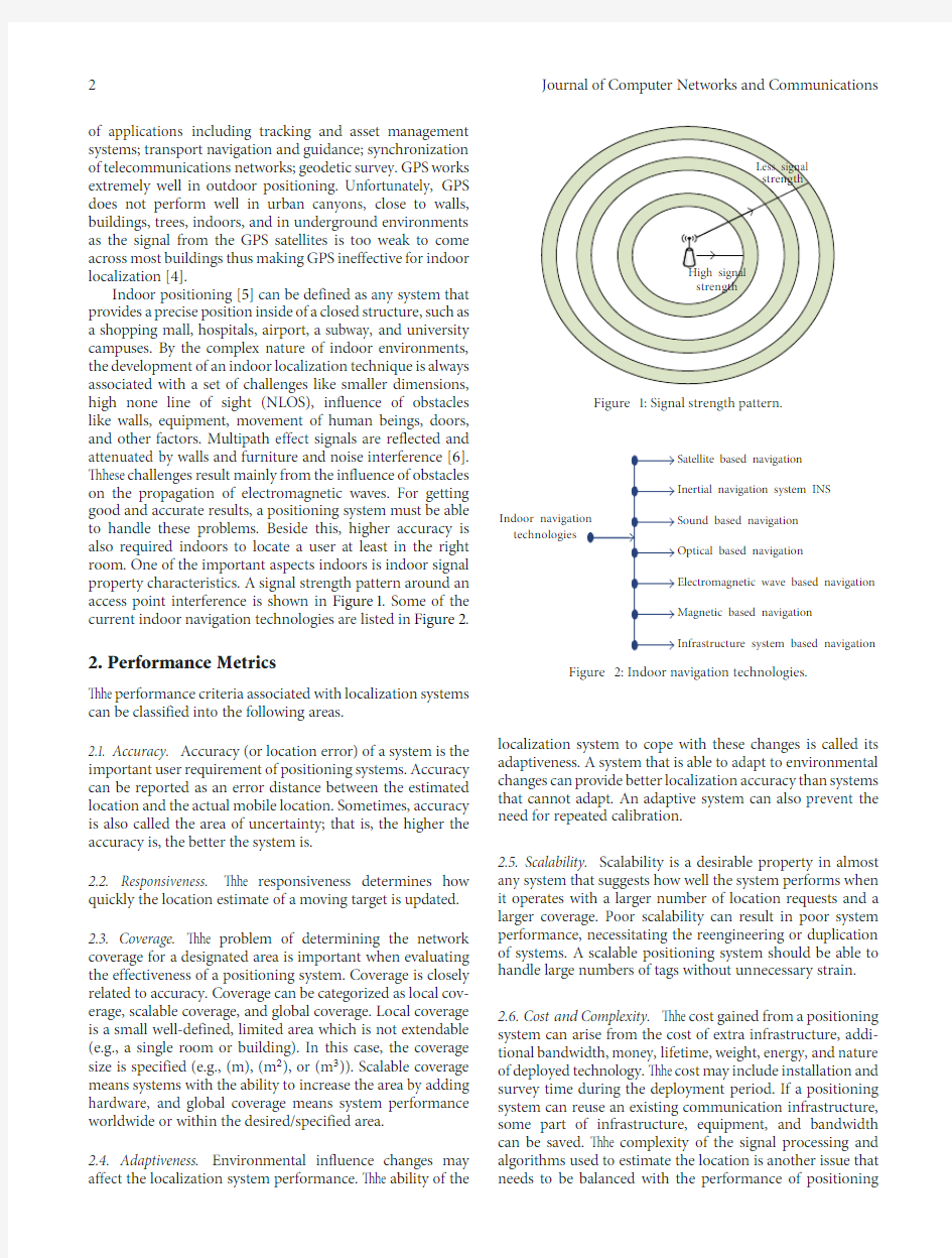
Indoor positioning[5]can be defined as any system that provides a precise position inside of a closed structure,such as a shopping mall,hospitals,airport,a subway,and university campuses.By the complex nature of indoor environments, the development of an indoor localization technique is always associated with a set of challenges like smaller dimensions, high none line of sight(NLOS),influence of obstacles like walls,equipment,movement of human beings,doors, and other factors.Multipath effect signals are reflected and attenuated by walls and furniture and noise interference[6]. These challenges result mainly from the influence of obstacles on the propagation of electromagnetic waves.For getting good and accurate results,a positioning system must be able to handle these problems.Beside this,higher accuracy is also required indoors to locate a user at least in the right room.One of the important aspects indoors is indoor signal property characteristics.A signal strength pattern around an access point interference is shown in Figure1.Some of the current indoor navigation technologies are listed in Figure2.
2.Performance Metrics
The performance criteria associated with localization systems can be classified into the following areas.
2.1.Accuracy.Accuracy(or location error)of a system is the important user requirement of positioning systems.Accuracy can be reported as an error distance between the estimated location and the actual mobile location.Sometimes,accuracy is also called the area of uncertainty;that is,the higher the accuracy is,the better the system is.
2.2.Responsiveness.The responsiveness determines how quickly the location estimate of a moving target is updated.
2.3.Coverage.The problem of determining the network coverage for a designated area is important when evaluating the effectiveness of a positioning system.Coverage is closely related to accuracy.Coverage can be categorized as local cov-erage,scalable coverage,and global coverage.Local coverage is a small well-defined,limited area which is not extendable (e.g.,a single room or building).In this case,the coverage size is specified(e.g.,(m),(m2),or(m3)).Scalable coverage means systems with the ability to increase the area by adding hardware,and global coverage means system performance worldwide or within the desired/specified area.
2.4.Adaptiveness.Environmental influence changes may affect the localization system performance.The ability of
the
Figure1:Signal strength
pattern.
technologies
Figure2:Indoor navigation technologies. localization system to cope with these changes is called its adaptiveness.A system that is able to adapt to environmental changes can provide better localization accuracy than systems that cannot adapt.An adaptive system can also prevent the need for repeated calibration.
2.5.Scalability.Scalability is a desirable property in almost any system that suggests how well the system performs when it operates with a larger number of location requests and a larger coverage.Poor scalability can result in poor system performance,necessitating the reengineering or duplication of systems.A scalable positioning system should be able to handle large numbers of tags without unnecessary strain. 2.6.Cost and Complexity.The cost gained from a positioning system can arise from the cost of extra infrastructure,addi-tional bandwidth,money,lifetime,weight,energy,and nature of deployed technology.The cost may include installation and survey time during the deployment period.If a positioning system can reuse an existing communication infrastructure, some part of infrastructure,equipment,and bandwidth can be saved.The complexity of the signal processing and algorithms used to estimate the location is another issue that needs to be balanced with the performance of positioning
systems.Tradeoffs between the system complexity and the accuracy affect the overall cost of the system.
3.Location Detection Techniques and Location Algorithms
Several different methods are used for location techniques and algorithms in wireless based localization.Location detec-tion techniques can be divided into three general categories: proximity,triangulation and scene analysis as shown in Figure3.
3.1.Proximity Detection(Connectivity Based Positioning). Proximity detection or connectivity based is one of the simplest positioning methods to implement.It provides sym-bolic relative location information.The position of mobile client is determined by cell of origin(CoO)method with known position and limited range[7].When more than one beacon detects the mobile target,it simply forwards the position nearest where the strongest signal is received. The accuracy of CoO relates to the density of beacon point deployment and signal range.This method is implemented with several wireless positioning technologies,in particular, the system running infrared radiation(IR),radio frequency identification(RFID)GSM(Cell-ID),bluetooth,and custom radio devices[3].
3.2.Triangulation.Triangulation uses the geometric proper-ties of triangles to determine the target location.It has two derivations:lateration and angulation.Techniques based on the measurement of the propagation-time system(e.g.,TOA, RTOF,and TDOA)and RSS-based and received signal phase methods are called lateration technique[8,9].The AOA estimation technique is also called an angulation technique.
3.2.1.Angle Based Method
Angle of Arrival(AoA)/Angulation.The angle of arrival(AoA) technique determines the angle of arrival of the mobile signal coming from a known location at which it is received at multiple base stations[3].To estimate position in a2D dimension plane,AoA approach requires only two beacons. To improve accuracy,three beacons or more are used for location estimation(triangulation).For finding direction, it requires highly directional antennas or antenna arrays. Geometric relationships can then be used to estimate the location of the intersection of two lines of bearing(LoBs) from the known reference points as shown in Figure4.
AOA-based techniques have their limitations.AOA requires additional antennas with the capacity to measure the angles which increase the cost of the AOA system imple-mentation.In indoor environments,AOA-based methods are affected by multipath and NLOS propagation of signals,along with reflections from walls and other objects,so it is not good for indoor implementation.Due to these factors,it can significantly change the direction of signal arrival and thus degrade the accuracy of an indoor AOA-based positioning system[10
].
Figure3:Location detection based
classification.
Figure4:Angle-of-arrival positioning method.
3.2.2.Time Based Methods
Lateration/Trilateration/Multilateration.All three terms (lateration/trilateration/multilateration)refer to a position determined from distance https://www.360docs.net/doc/2e18484274.html,teration or trilateration determines the position of an object by measuring its distance from multiple reference points. Thus,it is also called range measurement technique.In trilateration,the“tri”says that at least three fixed points are necessary to determine a position.Techniques based on the measurement of the propagation-time system(e.g.,TOA, RTOF,and TDOA)and RSS-based and received signal phase methods are called lateration techniques[5,11].
Time of Arrival(ToA)/Time of Flight(ToF).Time of Arrival (ToA)systems are based on the accurate synchronization of the arrival time of a signal transmitted from a mobile device to several receiving beacons as shown in Figure5.In ToA, the mobile device transmits a time stamped signal towards receiving beacons.When it is received,the distance between the mobile node and the receiving beacons is calculated from the transmission time delay and the corresponding speed of the signal.
Figure5:Positioning based on TOA/RTOF measurements.
ToA method needs precise knowledge of the transmission start time(s).Due to this,all receiving beacons along with mobile devices are accurately synchronized with a precise time source.ToA is the most accurate technique used in indoor environment which can filter out multi-path effects [4].One of the disadvantages of TOA approach is the require-ment for precise time synchronization of all the devices. For time delay measurement,an additional server will be needed which will increase the cost of the system.Along with this,increased delay can also be propagated by a denser environment,in terms of more people.
Time Difference of Arrival(TDoA).Time Difference of Arrival (TDoA)techniques are measured between multiple pairs of reference points with known locations and use relative time measurements at each receiving node in place of absolute time measurements illustrated in Figure6.TDoA does not need the use of a synchronized time source of transmission in order to resolve timestamps and find the location.With TDoA,a transmission with an unknown starting time is received at various receiving nodes,with only the receivers requiring time synchronization[5].Each difference of arrival time measurement produces a hyperbolic curve in the local-ization space on which the location of the mobile node lies. The intersection of multiple hyperbolic curves specifies the possible locations of the client.Localization using TDOA is called multilateration.
Round Trip Time(RTT)/Round-Trip Time of Flight(RToF). It measures the time of flight of the signal pulse traveling from the transmitter to the measuring unit and back[3].In TOA,calculating the delay is by using two local clocks in both nodes,while in RTT,it uses only one node to record the transmitting and arrival times.Because of this advantage, this technology solves the problem of synchronization to some extent.One of the drawbacks of this method is range measurements to multiple devices that need to be carried out consecutively which may cause precarious latencies for applications where devices move quickly.
3.2.3.Signal Property Based Method.The majority of wireless localization systems compute the distance to the
positioning
Figure6:Time difference of arrival(source[31]). device using either timing information or angle based.In both scenarios,they are influenced by the multipath effect. Due to this,the accuracy of estimated location can be decreased.The substitute method is to estimate the distance of unknown node to reference node from some sets of mea-suring units using the attenuation of emitted signal strength [3,12].This method can only be possible with radio signals. Mostly wireless localization systems positioning device using properties of the received signal,with received signal strength indicator(RSSI)being the most widely used signal-related feature.RSSI measurement estimations depend heavily on the environmental interference,and they are also nonlinear. These methods work with the WiFi technology.As this system needs a server for implementation,this technique can work using only access points which are cheaper than Wi-Fi routers.
3.3.Dead Reckoning(DR).Dead reckoning is the process of estimating known current position based on last determined position and incrementing that position based on known or estimated speeds over elapsed time.An inertial navigation system which provides very accurate directional information uses dead reckoning and is very widely applied[13].One of the disadvantages of dead reckoning is that the inaccuracy of the process is cumulative,so the deviation in the position fix grows with time.The reason is that new positions are calculated entirely from previous positions.Research has been carried out[13,14]in indoor localization using dead reckoning.
3.4.Map Matching(MM).This method is based on the theory of pattern recognition[15]which combines electronic map with locating information to obtain the real position of vehicles in a road network.The use of maps is an efficient alternative to the installation of additional hardware.MM techniques include topological analyses,pattern recognition, or advanced techniques such as hierarchical fuzzy inference algorithms.The authors of[16,17]present a recent research work on map matching algorithm based on indoor and LBS, respectively.
4.Position Systems
This section presents a review of most prominent state-of-the-art wireless positioning systems as shown in Figure7. Our main focus is put on the radio based systems especially in wireless local area network(WLAN)positioning(Table1).
Global positioning system(GPS)is the most popular and worldwide radio navigation system to find the location and the position of the objects especially for outdoor environment [18].However,it does not work well in indoor setups because the presence of obstacles in the line of sight between the satellite and the receiver and electromagnetic waves is spread and attenuated by the buildings and outdoor obstacles[8]. As people spend most of their time in a closed environment (indoors),GPS is not well suited for indoor positioning tracking(Table3).
Infrared radiation(IR)positioning systems are one of the most common positioning systems that use wireless technology.The spectral region of infrared has been used in various ways for detection or tracking of objects or persons and available in various wired and wireless devices such as mobile phone,PDAs,and TV[19].Most IR based wireless devices uses line-of-sight(LOS)communication mode between transmitter and receiver without interference from strong light sources[20].The main advantage of using IR based system devices is being small,lightweight,and easy to carry out.The IR systems undertake an indoor positioning determination in a precise way.Besides these,IR based indoor positioning systems have some disadvantages like security and privacy issues.IR signals have some limitations for location determination,like interference from fluorescent light and sunlight[4].Beside this,the IR based indoor system has expensive system hardware and maintenance cost.
Radio frequency technologies[21]are commonly used in location position systems because of some advantages;for example,radio waves can penetrate through obstacles like building walls and human bodies easily.Due to this,the positioning system in RF based has a larger coverage area and needs less hardware comparing to other systems.In addition, RF based technologies are further divided into narrow band based technologies(RFID,bluetooth,WLAN,and FM)and wide band based technologies(UWB)[19].RADAR[22] by Microsoft Research was the first RF based technique for location determination and user tracking.
Radio frequency identification(RFID)has been recog-nized as the next promising technology in serving the posi-tioning system for locating objects or people.RFID enables a one way wireless communication using a noncontact and advanced automatic identification technology that uses radio signals that put an RFID tag on people or objects,for the purpose of automatic identification,tracking,and manage-ment.Tracking the movements of objects in RFID is done through a network of radio enabled scanning devices over a distance of several meters.RFID technology is used in a wide range of applications including people,automobile assembly industry,warehouse management,supply chain network,and assets without the need of line of sight contact[9].
Bluetooth is a wireless standard for wireless personal area networks(WPANs).Almost every WiFi enabled mobile device,such as mobile phone or computer,also has an embed-ded bluetooth module.Bluetooth operates in the2.4GHz ISM band.The benefit of using bluetooth for exchanging information between devices is that this technology is of high security,low cost,low power,and small size.Each bluetooth tag has a unique ID,which can be used for locating the Bluetooth tag.There are several recent research works dedicated to bluetooth based localization systems[23,24]. One of the drawbacks of using bluetooth technology in localization is that,in each location finding,it runs the device discovery procedure;due to this,it significantly increases the localization latency(10–30s)and power consumption as well. That is why bluetooth device has a latency unsuitable for real-time positioning applications.
Ultrawideband(UWB)is a radio technology for short-range,high-bandwidth communication holding the proper-ties of strong multipath resistance.Widespread use of UWB in a variety of localization applications requiring higher accuracy20–30cm than achievable through conventional wireless technologies(e.g.,radio frequency identification (RFID),wireless local area networks(WLAN),etc.)[25].A typical UWB setup structures stimulus radio wave generator and receivers which capture the propagated and scattered wave.Moreover,UWB hardware is expensive,making it costly for wide-scale use.
The FM radio based system is popular through the ages. It is widely available across the globe especially in most households and in cars.FM radio uses the frequency-division multiple access(FDMA)approach which splits the band into a number of separate frequency channels that are used by stations.FM band ranges and channel separation distances vary in different regions.There are only a few works dedicated to FM radio based positioning.Recently[26,27]presented research that worked on indoor positioning using FM radio signals.
The ZigBee technology is an emerging wireless technol-ogy standard which provides solution for short and medium range communications due to its numerous benefits[28].It is mainly designed for applications which require low-power consumption but do not require large data throughput.The signal range coverage of a ZigBee in indoor environments is typically20m to30m.Distance calculation between two ZigBee nodes is usually carried out from RSSI values.ZigBee is open to interference from a wide range of signal types using the same frequency which can disrupt radio communication because it operates in the unlicensed ISM bands.Hu et al.[7] deployed a ZigBee based localization algorithm for indoor environments.Beside this,Fern′a ndez et al.[29]proposed a way to improve the position determination in an indoor location system(ILS)based on the power levels(RSSI)of an ad hoc ZigBee network.
Hybrid positioning systems are defined as systems for determining the location of a mobile client combining sev-eral different positioning technologies[30].Many location technologies are used to estimate the position of mobile client in a space or grid,based on some mathematical models.The local positioning systems fail to work outdoors,whereas the GPS based positioning systems do not work inside buildings due to the absence of line of sight to the satellites.So,there
WLAN RFID Bluetooth ZigBee UWB FM Hybrid Figure7:Taxonomy of position systems.
is a need for positioning systems that can work both indoors and outdoors,and hence,the concept of hybrid positioning systems is used[31].Different hybrid positioning systems are currently being developed and used in services from Combain Mobile,Navizon,Xtify,PlaceEngine,SkyHook, Devicescape,Google Maps for Mobile,and sopenBmap for application in smartphones.
Ultrasound system is a technology based on the nature of bats and operates in the low frequency band compared to the other two signaling technologies.The ultrasound signals are used to estimate the position of the emitter tags from the receivers.Ultrasound is unable to penetrate walls but reflects off most of the indoor obstructions.However,it has a lower level of accuracy(in centimeters)and suffers a lot of interference from reflected ultrasound signals propagated around by other sources such as the collision of metals. Some recent research work[32,33]was carried out under ultrasound based indoor localization.
4.1.WiFi-Based Indoor Localization.One of the advantages of using WiFi Positioning Systems is to locate the position of almost every WiFi compatible device without installing extra software or manipulating the hardware.Beside this,in WLAN,line of sight is not required.Due to this advantage, WiFi positioning systems have become the most widespread approach for indoor localization[11].
Most positioning systems based on WLAN(WiFi)are available as commercial products as prototypes based on measurements on the received signal strength(RSS).WiFi based positioning systems have several advantages.
Firstly in terms of cost effect,WLAN infrastructures implementation of position algorithms does not need any additional hardware as network interface cards(NICs)mea-sure signal strength values from all wireless access points in range of the receiver.Therefore,signals needed for posi-tioning can be obtained directly from NICs available on most handheld computing devices.Due to the ubiquity of WLANs,this mode of positioning provides a particularly cost-effective solution for offering LBS in commercial and residential indoor environments[34].Secondly,WLAN posi-tioning systems offer scalability in two respects:first,no costly requirement of infrastructure and hardware and second the number of mobile devices subscribing to positioning services. Beside this,there are also certain WLAN limitations:signal attenuation of the static environment like wall,movement of furniture and doors.Some of the WiFi strengths,weaknesses, and opportunities are presented in Table2.
4.2.Fingerprinting Based Indoor Localization.Most indoor localization approaches adopted fingerprint matching as the basic scheme of location determination.The main theme is to collect features of the scene(fingerprint)from the surround-ing signatures at every location in the areas of interest and then build a fingerprint database.The location of an object is then determined by matching online measurement with the closed location against the database[35](Figure8).
This method does not require specialized hardware in either the mobile device or the receiving end nor is no time synchronization necessary between the stations.It may be implemented totally in software which can reduce complexity and cost significantly compared to angulation or purely time-based lateration systems[34].
The location fingerprinting also called a fingerprinting method consists of two phases[5].Phase1is the so-called calibration phase,offline phase,or training phase,and phase 2is the localization phase or online phase.In the offline phase,maps for fingerprinting are set up either empirically in measurement operations or computed analytically(signal strength reference values(anchor point)can be computed using a signal propagation model).In the first phase,a creation of radio maps for site survey where the positioning is supposed to work must be recorded.Basically,radio map is a database of spots at predefined points(coordinates) coupled with various radio signal characteristics,for exam-ple,RSS,signal angles,or propagation time called signal fingerprints.Step by step,for every fingerprint,there must
Table1:Comparisons of indoor position methods.
Method Measurement
type
Indoor
accuracy
Coverage
Line of sight
(LOS)/nonline-
of sight
(NLOS)
Affected
by
multipath
Cost Notes
Proximity
Signal type Low to
high
Good Both No Low
(1)Accuracy can be improved by using
additional antenna.However,it will
increase the cost.
(2)Accuracy is on the order of the size
of the cells.
Direction(AoA)Angle of
arrival
Medium
Good
(Multipath
issues)
LOS Y es High
(1)Accuracy depends on the antenna’s
angular properties.
(2)Location of antenna must be
specified.
Time(ToA, TDoA)
Time
difference of
arrival
High
Good
(Multipath
issues)
LOS Y es High
(1)Time synchronization needs.
(2)Location of antenna must be
specified.
Fingerprinting Received
signal
strength
High Good Both No Medium
(1)Need heavy calibration.
(2)Location of antenna is not
necessary.
Dead reckoning Acceleration,
velocity
Low to
medium
Good NLOS Y es Low
Inaccuracy of the process is
cumulative,so the deviation in the
position fix grows with time.
Map matching An algorithm
based on
algorithms
based on
projection
and pattern
recognition
Medium
Medium
(indoor)
Good
(outdoor)
NLOS Y es Medium
(1)Map matching purely focus on
algorithms and not fully on position
methods,coordinate transformation,
and geocoding.
(2)Using pattern recognition,high
computing complex and poor real time
issue occur.
Table2:WiFi strengths,weaknesses,and opportunities.
Strengths (i)Found in almost every building,fairly good
available signal strengths.
(ii)WiFi signals are able to penetrate walls in
where GPS fails.
(iii)Targeted location fingerprints available.
Weaknesses
(i)Site surveying time consuming and labor
intensive.
(ii)Multipath influenced by presence of
Physical objects.
(iii)Signal strength changes in variations due
to time.
(iv)Interfere possible with other appliances in
the2.4GHz ISM.
Opportunities
(i)Fingerprinting does not need geometric
surveys.
(ii)Fingerprinting only necessary at selected
places.
be a measurement that includes the information about all stations and their received signal strength(RSS).When the localization system is operational,online phase,the mobile station measures signal properties at unknown spot.Then, the current measured signal strength values are compared for the best agreement with a database(radio map).The major drawback of the fingerprinting approach is the laborious and time-consuming calibration process.Furthermore,adding signal stations would challenge the ease of setup in finger-printing.Beside this,the main challenge to the techniques based on location fingerprinting is sensitivity to environment changes such as object moving into the building(e.g.,people, furniture),diffraction,and reflection,which result in changes in signal propagation.To maintain the positioning accuracy, the calibration process should be periodically repeated to a recalculation of the predefined signal strength map.
Fingerprinting-based positioning algorithms using pat-tern recognition techniques are deterministic and probabilis-tic,K-nearest-neighbor(K NN),artificial neural networks, Bayesian inference,support vector machine(SVM),or their combinations.
In this part of paper,we are presenting some recent research work done on WiFi localization with a specific focus on fingerprinting-based localization technique.
Different approaches using WiFi access points are studied from time to time.Pereira et al.[36]developed a functional application for a smartphone indoor/outdoor localization system publicly available for download with a name called “Locate Me.”It was developed for mobile devices running Android OS and takes advantage of the GPS and WiFi modules to acquire the location of a person.With this system,anybody can find their friends wherever they are. The application sends the current location of the device to the server where it is stored.From that moment on,
Table3:Comparison of common position systems used for localization.
System Accuracy Principles used
for localization
Coverage
Power
consumption
Cost Remarks
GPS
6m–10m ToA Good outdoor
Poor indoor
Very high High
(1)Satellite based
Positioning.
(2)Processing time and
computation is slow.
Infrared1m-2m Proximity,ToA Good Indoor Low Medium (1)Short range detection.
(2)No invasion of
multipath.
WiFi1m–5m Proximity,ToA,
TDoA,RSSI
Fingerprinting,
and RSSI
theoretical
propagation
model
Building level
(outdoor/indoor)
High Low
(1)Infrastructure available
everywhere.
(2)Initial deployment is
expensive.
(3)Multipath susceptible
slightly.
Ultrasound3cm–1m ToA,AoA Indoor Low Medium
(1)Sensitive to environmental.
(2)No invasion of
multipath.
RFID1-2m Proximity,TOA,
RSSI theoretical
propagation
model
Indoor Low Low
(1)Real time location
system.
(2)Response time is high.
(3)Manual programming.
Bluetooth2m–5m
RSSI
fingerprinting
and RSSI
theoretical
propagation
model
Indoor Low High
(1)Data transfer speed is
high.
(2)Limitation in mobility.
ZigBee3m–5m
RSSI
fingerprinting
and RSSI
theoretical
propagation
model
Indoor Low Low
(1)Low data transmission
rate.
(2)Nodes are mostly asleep.
FM2m–4m
RSSI
fingerprinting
Indoor Low Low
(1)Less susceptible to
objects.
(2)Signal is strong;due to
this,it covers large areas.
cm:centimeters;m:meters.
all friends can access this position and see it on the map. Google Maps Android API is used to represent the users’location,and it has two views available:road view and satellite view.This location system is based on4different methods of localization,three for indoor environments and one for outdoors.The fingerprint localization method is used for indoor location.
Indoor localization using WiFi based fingerprinting and trilateration techniques for LBS application is presented by S.Chan et al.[37].The paper combined two different WiFi approaches to locate a user in an indoor environment.The first method involves the use of fingerprint matching to compare signal strength data received from nearby access points(AP)by the user,to the reference data stored in the WiFi signal strength database.The second approach uses distance-based trilateration approach using three known AP coordinates detected in the user’s device to derive the posi-tion.The combination of the two steps enhances the accuracy of the user position in an indoor environment allowing location based services(LBS)such as mobile augmented reality(MAR)to be deployed more effectively in the indoor environment.An improvement is necessary for finding the correct match for the fingerprinting method with help of incorporating certain database correlation algorithms such as K-nearest-neighbor or probabilistic like a hidden Markov model.
In[38],the authors design a multifloor indoor posi-tioning system based on Bayesian graphical models(BGM). In this paper,the author first studied the RSS properties that will affect the overall accuracy of our model like a
Mobile user
Mobile user
Offline phase:collection of fingerprint
Online phase:localization
Figure 8:Fingerprinting based positioning.
normal distribution of RSS,using RSS in infer location,and multifloor effect.Markov chain Monte Carlo (MCMC)sampling techniques are used.At the last stage,the author tested their model with four sets of MCMC sampling tech-niques and compared their results with two well-known location determination systems (RADAR and the Horus).The achieved accuracy is 2:3m in a multi-floor environment with a small amount of training points.
By using Wi-Fi,it is possible to define the position of people or assets with good accuracy.In [39],the authors proposed a novel positioning algorithm named predicted K-nearest-neighbor (PKNN )which estimates the current position of a mobile user not only by using K found neighbors but also by utilizing its previous positions and speed.In the first stage of the experiment,weighted K -nearest neighbors (WKNN )are used for the position of the tag which is to be estimated.In the second stage,prediction is done for the next probable displacement,based on previous user positions and speeds of Wi-Fi tags.The performance of PKNN for indoor positioning has been evaluated by the experimental test bed.By comparison with KNN,PKNN performs well by 33%or at mean 1.3meter improvement in error.
A novel,information-theoretic approach is presented by Fang and Lin [40]for building a WLAN-based indoor posi-tioning system based on the location fingerprinting system.The proposed technique is based on principal component analysis (PCA)which transforms received signal strength (RSS)into principal components (PCs)such that the infor-mation of all access points (APs)is more efficiently utilized.Instead of selecting APs for the positioning which was done by previous researchers,the proposed technique changes the elements with a subset of PCs improvement of accuracy and reduces the online computation.The comparison has been done with AP selection and the Horus system.The proposed approach delivers a significantly improved accuracy.The results show that the mean error is reduced by 33.75percent and the complexity is decreased by 40percent.Received signal strength indication (RSSI)is defined by the IEEE 802.11Standard.It is a measurement of the RF energy,and the unit is dBm.Mobile client (MC)can get the RSSI from access point (AP)on the WLAN.The RSSI is decreased exponentially as the distance from AP increased,and this can be expressed by log path loss model.Reference [41]has been presented,using Dominant AP’S RSSI Localization (DARL)https://www.360docs.net/doc/2e18484274.html,ing dual log model because of attenuation factor,the parameters are classified into two parts.Firstly,DARL algorithm uses the strongest RSSI from an AP .Secondly,AP trace-back algorithm was suggested as the method for updating the information of unknown AP on the radio map.Optimal filtering system to the proposed algorithm is needed for getting more increased accuracy.
Fingerprinting accuracy performance depends on the number of base stations and the density of calibration points where the fingerprints are taken.Recorded RSSI varies in time,even if there are no changes to the environment.In order to eliminate the deviation of attenuation in the signal,the RSS values are to be averaged over a certain time interval up to several minutes at each fingerprint location.Hansen et al.[42]draw on active user participation relying on the contribution of end users by marking their location on a floor plan while recording the fingerprints.The author concludes from long-term measurements over a period of two months that static radio maps cannot be used for room identification even in modest dynamic environments and therefore recommends dynamically adapting algorithms.
In [43],the author presents the design,implementation,and evaluation of a fine-grained indoor fingerprinting system (FIFS)as shown in Figure 5.Data are modulated on multiple subcarriers at different frequencies and transmitted simul-taneously in Orthogonal frequency division multiplexing (OFDM).The author takes the value that estimates the channel in each subcarrier called channel state information (CSI).Different from RSSI,CSI is a fine-grained value from
the PHY layer which describes the amplitude and phase on each subcarrier in the frequency domain.To obtain high accuracy and low complexity of indoor localization,the FIFS was comprised of two parts:first,the process of raw CSI values of measurement by integrating frequency diversity (amplitudes and phases at multiple propagation paths)and spatial diversity of location using multiple antennas,and then it builds up a radio map;second,determining the position of objects by correlation calculation augmented with a probability algorithm.An experiment is done in two typical indoor scenarios with commercial IEEE802.11NICs.The median accuracy of0:65m is improved compared with the RSS-based Horus system0.2with gain of about24%.
Aboodi and Tat-Chee[44]proposed an indoor position-ing algorithm called WiFi-based indoor(WBI)positioning algorithm.WBI-based on WiFi received signal strength(RSS) technology in conjunction with trilateration techniques.The WBI algorithm estimates the location using RSS values previously collected from within the area of interest using LSE algorithm,determines whether it falls within the Min-Max bounding box,corrects for nonline-of-sight propagation effects on positioning errors using Kalman filtering,and finally updates the location estimation using least square estimation(LSE).The paper analyzed the complexity of the proposed algorithm and compares its performance against existing algorithms.Furthermore,the proposed WBI algo-rithm achieves an average accuracy of2.6m.
The authors of[45]proposed a GPS-Like zero-configuration indoor positioning system based on received signal strength(RSS)of the popular WiFi network as shown in Figure9.The proposed system does not require a time-consuming offline radio survey prior knowledge about the area or new hardware unlike current RSS-based indoor systems.Similar to GPS,the proposed system consists of three sections as shown in Figure9:network segment (WiFi),control segment,and user segment.Between network segment and control segment,RSS observations are exchanged periodically.The control segment uses a novel hybrid propagation modeling(PM)technique using logarithmic decay model augmented by a nonlinear Gaussian process regression(GPR)that models RSS residuals that cannot be modeled by the traditional logarithmic decay models indoors.The proposed system provides2-3m accuracy in indoor environments.
Yang et al.[46]proposed a wireless indoor localization approach called Locating in fingerprint space(LiFS).In fingerprinting method,radio base requires a process of site survey,in which radio signatures of an interested area are marked with their real recorded locations.Site survey involves intensive costs on manpower and time and is vul-nerable to environmental dynamics.The author investigates the sensors integrated in modern mobile phones and user motions to construct the radio map of a floor plan,which is previously obtained only by site survey.On this basis,they design LiFS,an indoor localization system based on off-the-shelf WiFi infrastructure and mobile phones.An experiment was performed in an office building covering over1600m2, and the results show that LiFS achieves low human cost,rapid system
deployment.
Figure9:Simplified block diagram[45].
IEEE802.11n is an amendment to the IEEE802.11-2007wireless networking standard to improve network throughput over the two previous standards—802.11a and 802.11g—with a significant increase in the maximum net data rate from54Mbit/s to600Mbit/s.It also improves WLAN standard in terms of network throughput by adding a technology which supports multiple antenna configurations, known as multiple-input multiple-output(MIMO).Xiong and Jamieson[47]presented ArrayTrack,an indoor location system that uses angle-of-arrival techniques to locate wireless clients indoors in a wireless local area network.ArrayTrack combines best of breed algorithms for AoA based direction estimation and spatial smoothing with novel algorithms for suppressing non-line-of-sight reactions that occur frequently indoors.Based on simulation,ArrayTrack achieved median 25cm location accuracy when clients are stationary indoors.
5.Conclusion and Future Trends
This paper surveys the recent advances in wireless indoor localization techniques and system.Different technological solutions for wireless indoor positioning and navigation are discussed,and several tradeoffs among them are observed. Regardless of the plenty of approaches which exist to handle the indoor positioning problem,current solutions cannot cope with the performance level that significant applications required.In short,requirements for different application environments are accuracy/precision,coverage,availability, and minimal costs for local installations.To achieve this shortcoming,a good portion of research approaches is required to handle these challenges.Some of the future trends of wireless indoor positioning systems are as follows:
(1)new hybrid solution for positioning and tracking
estimation in4G with the currently available position
system,
(2)need of cooperative mobile localization which will
help mobile nodes among each other to determine
their locations,
(3)new innovative applications for mobile in which loca-
tion information can be used to improve the quality of
users’experience and to add value to existing services
offered by wireless providers. Acknowledgments
The authors would like to thank the National University of Malaysia and the Ministry of Science,Technology and Innovation for the financial support of this work,under the Grant Ref.01-01-02-SF0788.The authors also would like to thank the anonymous reviewers for their valuable feedback. References
[1]Y.Liu and Z.Yang,Location,Localization,and Localizability.
Location-awareness Technology for Wireless Networks,Springer, 2010.
[2]D.Mohapatra and S.B.Suma,“Survey of location based wireless
services,”in Proceedings of the7th IEEE International Conference on Personal Wireless Communications(ICPWC’05),pp.358–362,January2005.
[3]H.Liu,H.Darabi,P.Banerjee,and J.Liu,“Survey of wireless
indoor positioning techniques and systems,”IEEE Transactions on Systems,Man and Cybernetics Part C,vol.37,no.6,pp.1067–1080,2007.
[4]Y.Gu,A.Lo,and I.Niemegeers,“A survey of indoor positioning
systems for wireless personal networks,”IEEE Communications Surveys and Tutorials,vol.11,no.1,pp.13–32,2009.
[5]D.Zhang,F.Xia,Z.Yang,L.Yao,and W.Zhao,“Localization
technologies for indoor human tracking,”in Proceedings of the 5th International Conference on Future Information Technology (FutureTech’10),May2010.
[6]J.Yiming,Indoor Location Determination,in Location-Based
Services Handbook,CRC Press,2010.
[7]X.Hu,L.Cheng,and G.Zhang,“A Zigbee-based localization
algorithm for indoor environments,”in Proceedings of the International Conference on Computer Science and Network Technology(ICCSNT’11),pp.1776–1781,December2011. [8]F.Seco,A.R.Jim′e nez,C.Prieto,J.Roa,and K.Koutsou,
“A survey of mathematical methods for indoor localization,”
in Proceedings of the6th IEEE International Symposium on Intelligent Signal Processing(WISP’09),pp.9–14,August2009.
[9]M.Vossiek,L.Wiebking,M.Gl¨a nzer,D.Mastela,and M.
Christmann,“Wireless local positioning—concepts,solutions, applications,”in Proceedings of the IEEE Radio and Wireless Conference(RA WCON’03),pp.219–224,August2003. [10]Cisco System,Wi-Fi Location-Based Services4.1Design Guide,
2008.
[11]M.B.Ismail,A.F.A.Boud,and W.N.W.Ibrahim,“Implemen-
tation of location determination in a wireless local area network (WLAN)environment,”in Proceedings of the10th International Conference on Advanced Communication Technology(ICACT ’34),pp.894–899,February2008.
[12]S.Gezici,“A survey on wireless position estimation,”Wireless
Personal Communications,vol.44,no.3,pp.263–282,2008. [13]H.Samuel,S.Connell,https://www.360docs.net/doc/2e18484274.html,ligan,D.Austin,T.L.Hayes,and P.
Chiang,“Indoor localization using pedestrian dead reckoning updated with RFID-based fiducials,”in Proceedings of the 33rd Annual International Conference of the IEEE Engineering
in Medicine and Biology Society(EMBS’11),pp.7598–7601, September2011.
[14]D.Pai,M.Malpani,I.Sasi,N.Aggarwal,and P.S.Mantripra-
gada,“A Robust pedestrian dead reckoning system on smart-phones,”in Proceedings of the IEEE11th International Conference on Trust,Security and Privacy in Computing and Communica-tions(TrustCom’12),pp.2000–2007,June2012.
[15]M.A.Quddus,W.Y.Ochieng,and R.B.Noland,“Integrity of
map-matching algorithms,”Transportation Research Part C,vol.
14,no.4,pp.283–302,2006.
[16]M.Attia,A.Moussa,X.Zhao,and N.El-Sheimy,“Assisting
personal positioning in indoor environments using map match-ing,”Archives of Photogrammetry,Cartography and Remote Sensing,vol.22,pp.39–49,2011.
[17]A.M.Ahmed,W.Zhu,and T.M.Bekele,“Map-matching and
positioning uncertainty in Location Based Services(LBS),”in Proceedings of the International Conference on Asia Agriculture and Animal,Singapoore,2011.
[18]2013,https://www.360docs.net/doc/2e18484274.html,/wiki/Global Positioning System.
[19]J.Xiao,Z.Liu,Y.Yang,D.Liu,and H.Xu,“Comparison
and analysis of indoor wireless positioning techniques,”in Proceedings of the International Conference on Computer Science and Service System(CSSS’11),pp.293–296,June2011.
[20]R.Casas,D.Cuartielles,′A.Marco,H.J.Gracia,and J.L.Falc′o,
“Hidden issues in deploying an indoor location system,”IEEE Pervasive Computing,vol.6,no.2,pp.62–69,2007.
[21]P.Vorst,J.Sommer,C.Hoene et al.,“Indoor positioning
via three different RF technologies,”in Proceedings of the4th European Workshop on RFID Systems and Technologies(RFID SysTech’08),pp.1–10,June2008.
[22]P.Bahl and V.N.Padmanabhan,“RADAR:an in-building RF-
based user location and tracking system,”in Proceedings of the19th Annual Joint Conference of the IEEE Computer and Communications Societies,pp.775–784,March2000.
[23]F.Subhan,H.Hasbullah,A.Rozyyev,and S.T.Bakhsh,“Indoor
positioning in Bluetooth networks using fingerprinting and lat-eration approach,”in Proceedings of the International Conference on Information Science and Applications(ICISA’11),April2011.
[24]H.J.Perez Iglesias,V.Barral,and C.J.Escudero,“Indoor person
localization system through RSSI Bluetooth fingerprinting,”in Proceedings of the19th International Conference on Systems, Signals and Image Processing(IWSSIP’12),pp.40–43,April2012.
[25]Z.Li,W.Dehaene,and G.Gielen,“System design for ultra-
low-power UWB-based indoor localization,”in Proceedings of the IEEE International Conference on Ultra-Wideband(ICUWB ’07),pp.580–585,September2007.
[26]A.Popleteev,V.Osmani,and O.Mayora,“Investigation of
indoor localization with ambient FM radio stations,”in Pro-ceedings of the IEEE International Conference on Pervasive Computing and Communications(PerCom’12),2012.
[27]V.Moghtadaiee,A.G.Dempster,and S.Lim,“Indoor local-
ization using FM radio signals:a fingerprinting approach,”in Proceedings of the International Conference on Indoor Positioning and Indoor Navigation(IPIN’11),September2011.
[28]ZigBee Technology,2013,https://www.360docs.net/doc/2e18484274.html,/About/
AboutTechnology/ZigBeeTechnology.aspx.
[29]S.Fern′a ndez,D.Gualda,J.C.Garc′?a,J.J.Garc′?a,J.Ure?n a,and
R.Guti′e rrez,“Indoor location system based on ZigBee devices and metric description graphs,”in Proceedings of the7th IEEE International Symposium on Intelligent Signal Processing(WISP ’11),pp.4–8,September2011.
[30]S.Zirazi,P.Canalda,H.Mabed,and F.Spies,“Wi-Fi access point
placement within stand-alone,hybrid and combined wireless positioning systems,”in Proceedings of the4th International Conference on Communications and Electronics(ICCE’12),pp.
279–284,2012.
[31]H.Mehmood and N.K.Tripathi,Hybrid Positioning Systems:A
Review,LAP LAMBERT Academic Publishing,2011.
[32]A.Runge,M.Baunach,and R.Kolla,“Precise self-calibration of
ultrasound based indoor localization systems,”in Proceedings of the International Conference on Indoor Positioning and Indoor Navigation(IPIN’11),September2011.
[33]C.Medina,J.C.Segura,and S.Holm,“Feasibility of ultrasound
positioning based on signal strength,”in Proceedings of the International Conference on Indoor Positioning and Indoor Navigation(IPIN’12),pp.1–9,November2012.
[34]C.Marc,M.E.Israel,and B.A.Francisco,“Location in wireless
local area networks,”in Location-Based Services Handbook,pp.
67–90,CRC Press,2010.
[35]M.A.Y oussef,A.Agrawala,and A.U.Shankar,“WLAN
location determination via clustering and probability distribu-tions,”in Proceedings of the1st IEEE International Conference on Pervasive Computing and Communications(PerCom’03),pp.
143–150,March2003.
[36]C.Pereira,L.Guenda,and B.N.Carvalho,“A smart-phone
indoor/outdoor localization system,”in Proceedings of the Inter-national Conference on Indoor Positioning and Indoor Naviga-tion(IPIN’11),2011.
[37]S.Chan and G.Sohn,“Indoor localization using Wi-Fi based
fingerprinting and trilateration techiques for LBS applications,”
in Proceedings of the7th International Conference on3D Geoin-formation,Quebec,Canada,May2012.
[38]A.S.Al-Ahmadi,A.I.Omer,M.R.Kamarudin,and T.A.Rah-
man,“Multi-floor indoor positioning system using bayesian graphical models,”Progress In Electromagnetics Research B,vol.
25,pp.241–259,2010.
[39]S.Khodayari,M.Maleki,and E.Hamedi,“A RSS-based
fingerprinting method for positioning based on historical data,”in Proceedings of the International Symposium on Perfor-mance Evaluation of Computer and Telecommunication Systems (SPECTS’2010),pp.306–310,July2010.
[40]S.-H.Fang and T.Lin,“Principal component localization
in indoor wlan environments,”IEEE Transactions on Mobile Computing,vol.11,no.1,pp.100–110,2012.
[41]P.DoWoo and P.Joon Goo,“An enhanced ranging scheme
using WiFi RSSI measurements for ubiquitous location,”in Proceedings of the1st ACIS/JNU International Conference on Computers,Networks,Systems and Industrial Engineering(CNSI ’11),2011.
[42]R.Hansen,R.Wind,C.S.Jensen,and B.Thomsen,“Algorithmic
strategies for adapting to environmental changes in802.11 location fingerprinting,”in Proceedings of the International Conference on Indoor Positioning and Indoor Navigation(IPIN ’10),Zurich,Switzerland,September2010.
[43]J.Xiao,K.Wu,Y.Yi,and L.M.Ni,“FIFS:fine-grained
indoor fingerprinting system,”in Proceedings of the21st Interna-tional Conference on Computer Communications and Networks (ICCCN’12),2012.
[44]A.Aboodi and W.Tat-Chee,“Evaluation of WiFi-based indoor
(WBI)positioning algorithm,”in Proceedings of the3rd FTRA International Conference on Mobile,Ubiquitous,and Intelligent Computing(MUSIC’12),pp.260–264,June2012.[45]M.M.Atia,M.Korenberg,and A.Noureldin,“A consistent
zero-configuration GPS-Like indoor positioning system based on signal strength in IEEE802.11networks,”in Proceedings of the IEEE/ION Position Location and Navigation Symposium (PLANS’12),pp.1068–1073,April2012.
[46]Z.Yang,C.Wu,and Y.Liu,“Locating in fingerprint space:
wireless indoor localization with little human intervention,”
in Proceedings of the18th Annual International Conference on Mobile Computing and Networking(Mobicom’12),pp.269–280, 2012.
[47]J.Xiong and K.Jamieson,ArrayTrack:A Fine-Grained Indoor
Location System,ACM HotMobile,2012.
Impact Factor 1.730
28 Days Fast Track Peer Review All Subject Areas of Science Submit at https://www.360docs.net/doc/2e18484274.html,
Hindawi Publishing Corporation https://www.360docs.net/doc/2e18484274.html,
Volume 2013
The Scientific World Journal
无线电通信技术的应用现状与发展趋势
无线电通信技术的应用现状与发展趋势 发表时间:2018-12-18T11:43:54.620Z 来源:《基层建设》2018年第31期作者:张斌 [导读] 摘要:随着经济社会的快速发展,加快了信息化的脚步,在社会的各个领域无线通信技术也被广泛的使用,它让人们的生活效率更高、质量更好、内容更充实。 陕西烽火电子股份有限公司陕西宝鸡 721006 摘要:随着经济社会的快速发展,加快了信息化的脚步,在社会的各个领域无线通信技术也被广泛的使用,它让人们的生活效率更高、质量更好、内容更充实。无线电通信技术和有线电通信相比,具有不用架设传输线路线、脱离传输距离限制、传输距离远、通信灵活等优点,备受市场的青睐。现在人们生活的方方面面都离不开无线通信技术。无线电通信在高科技信息化时代拥有更大的发展机会。本文主要从无线电波的来源开始,对无线电通信技术目前的情况及其发展进行了论述。 关键词:无线电通信技术;应用;现状;趋势 随着当前无线电通信过程中的各个发展阶段,其在发展中的各种应用使得其成为当前信息技术发展过程中的主要手段和应用过程。随着当前人们对信息技术的要求不断增加,无线电通信技术的普及已成为社会发展的必然趋势,其在发展过程中的普及化只是一个时间问题。在通信方法随着当前科学技术不断的变化过程中,无线电通信技术愈来愈成为当前社会发展过程中的主要通信手段,拥有者广阔的市场。因此,在无线电通信技术通信方法应用开发的发展潜力无穷,这就使得我们在研究和开发的过程中对其展开全方位的施工方式,为无线电通信技术创新出谋划策,为全球信息化及经济全球化的通信事业贡献力量。 1.无线通信技术 无线通信技术包括无线基站、无线终端、应用管理服务器三部分组成,按照传输距离可以分为基于IEEE802.15 的无线个域网(WPAN)、基于IEEE802.11 的无线局域网(WLAN)、基于IEEE802.16 的无线城域网(WMAN)、基于IEEE802.20 的无线广域网(WWAN)等四类。无线通信技术按照不同的要求,可以划分为不同的类型。例如,按照移动性可以划分为移动接入式和固定接入式;按照带宽可以分为宽带无线接入和窄带无线接入;按照传输距离可以分为长距离无线接入和短距离无线接入等。 2.无线通信技术的历史 随着经济和社会的不断发展,对信息化技术的要求越来越高。无线通讯技术的创新不断涌现,并在社会中得到广泛应用。从而促进人们生活方式、工作方式、沟通方式、管理方式等发生重大改变,对人们生活质量的提高起到了很大的促进作用。通信技术从固定方式发展到移动方式,在移动通信发展过程中,大致经历了五个重要阶段: 第一阶段:20世纪20年代初至50年代初,移动通信技术主要应用于军用装备,这个阶段的移动通信设备是采用短波频及电子管技术,在50年代初,才出现了150MHZ VHF 单工汽车公用移动电话系统MTS。 第二阶段:20世纪50年代到60年代,这个时期的移动通信设备器件已开始向半导体过渡,频段扩展至UHF450MHZ,并形成了移动环境中的专用系统。同时,也很好的解决了移动通信网络与公用电话网的融合问题。 第三阶段:20世纪70年代初至80年代初,这个阶段提出了蜂窝移动通信系统,并在70年代末开始进行AMPS试验。频段扩展至800MHZ。 第四阶段:20世纪80年代初至90年代中,是第二代数字移动通信大发展时期,移动通信技术开始逐步向个人通信业务方向转变; 第五阶段:20世纪90年代中至今,适应移动数据、移动计算及移动多媒体运作需要的第三代移动通信技术开始兴起并应用,全球移动通信技术标准化工作加速推进,样机研制和现场试验蓬勃发展,第二代至第三代移动通信的平滑过渡,数据通信与多媒体业务需求不断增加。 3.无线电通信技术的发展现状 现今,无线通信产业两个重要特点是:1.大众移动通信发展十分强劲,新技术应用更新不断加快。但在一些国家和地区,存在发展不均衡问题。2.无线宽带通信技术的研究、应用不断发展。 全球移动市场呈总体增长,不均衡增长的趋势。北美、欧洲等发达国家的新增用户日益减少;而在亚洲、非洲等地区的发展中国家,用户数增长迅猛。从数据新业务市场的增长来看,韩国、日本呈现爆发态势,已成为全球移动通信发展的新热点。移动通信仍是发展最为迅速的领域,移动通信用户超过30亿人,四大3G标准(WCDMA、CDMA2000、TD - SCDMA、WiMAX)演进技术不断出现,商用进程加速,全球有10亿人被3G网络覆盖。光通信已成为电信业务传输的主要手段,近年来得到了高速发展。在超长距离传输方面,也已达到了4000km无中继的技术水平。源于移动电话对固定电话的巨大冲击,固网主导运营商开始寻求各种形式的FMC(Fixed Mobility Convergence,固定移动融合)整合服务。IMS(IP多媒体子系统)为网络融合提供了一个统一的结构,极大地促进了网络融合的进程,三网融合进程加速。 4 无线电通信技术的发展趋势 3.1 不同通信技术相互补充与融合 无线通信技术的种类使得他们在一些方面存在着很多的差异,主要表现在覆盖范围、使用领域、传输速率、技术水平等方面,但是也都有自身的优势和不足。因此,把不同的无线通信技术有机地融合起来,构成一体化的无线通信网络,达到优势互补的目的,从而提高无线通信技术的服务水平与服务领域,为人类社会带来更多的便捷。 3.2 无线通信技术和宽带无线接入技术有效结合 将这两个相结合,能够扩大无线通信技术的覆盖范围,并极大提高无线通信技术的数据传输速率。宽带无线接入技术基本应用于固定环境中的高速接入。要实现两种技术的融合,开发商应充分结合二者的技术特性以及应用范围,实现二者的有机结合,达到优势互补、资源整合的目的。 3.3 无线通信技术和网络NGN的有机融合 就NGN技术的发展趋势而言,固定网络会朝着信息化、高宽带化的信息通信方向发展。因此,基于这一发展背景,无线通信技术的相关传输方式便会得到广泛地应用,从而促进NGN技术的发展。实现系统化的技术整合,促进固定无线通信技术一体化的形成,充分发挥出不同无线通信技术的优势作用。不过,这个发展趋势要经历极为漫长的过程,需要在技术、资金、人力方面的投入。
无线定位技术
无线定位技术: 现在的社会,是一个没有隐私的社会,只要有设备和条件,别人想跟踪你的位置实在是太简单了,不管是你在大街上走还是在商场里逛,只要上面想,你的行踪都很难不被暴露。好比我们看大片,罪犯在这边打电话,FBI在那边定位,唧唧几声,就把你的大概方位确定了。千万别以为这是什么高深技术,我们天朝网警照样玩的转。而且,随着网络越来越向智能化和移动化发展,一些很有意思的应用都可能和将来的定位技术联系起来,在一定程度上影响我们的生活,比如twitter,Aardvark,包括一些很有前途的mobile game,等等。 Google Latitude一出后, 很多朋友都惊诧于无gps条件下其定位的准确性,也有不少人因此对通过wifi定位比较感兴趣。其实各式各样的无线通信技术都可以用来定位,由于通信距离的不同,有的可以用来室内定位,有的可以用来室外定位。 这里,我尝试着对一些逐渐在普及的定位技术做一些讲解,考虑到GPS的普及性, GPS定位原理和优缺点就在这里忽略了。其实无线定位的流程很简单,大概都遵从交换信号===>数据融合===>建模求解的步骤。下面就针对不同技术的不同重点,把这个过程分割介绍。 手机基站网络 通过基站网络的检测来进行户外定位是一个相对成本低, 成熟, 但是精度不高 的方法. 它的工作原理是这样的, 我们都知道, 手机要通信, 就需要通过蜂窝 网络和一个个基站交换数据,从而实现和别的手机的通信. 而考虑到双方通信的距离和现实中基站的放置密度,每一个手机都可能被覆盖于多个基站,如果能通过某种方法得到每个基站对于手机的检测数据,通过特定的data fusion技术,就可以大致估算初当前手机的位置。在这里,data fusion是最关键的技术,事实上也是下面会介绍的大多数其他定位技术的基础,所以花多点篇幅介绍一下。为了简化,我们只考虑二维平面情况,也就是说每个点都只有(x,y)值, 不考虑z平面。 以前常用的data fusion技术包括TOA — time of arrival data fusion, AOA — angle of arrival data fusion, 以及混合型技术. 假设下面这张图是一个分布示意图, 图中出现的几个基站(Base Station)都能和当前手机, 也就是MS(Mobile Station)所在位置通信.
定位技术
无线传感器网络定位技术综述 文章出处:发布时间:2011/07/22 | 3934 次阅读| 9次推荐| 0条留言 业界领先的TEMPO评估服务高分段能力,高性能贴片保险丝专为OEM设计师和工程师而设计的产品Samtec连接器完整 的信号来源每天新产品时刻新 体验完整的15A开关模式电源 摘要:首先介绍无线传感器网络定位技术的相关术语、评价标准等基本概念及定位算法的分类方法;重点从基于测距和非测距两个方面介绍无线传感器网络的主要定位方法,并研究和分析若干新型无线传感器网络定位方法,主要包括基于移动锚节点的定位算法、三维定位算法和智能定位算法。从实用性、应用环境、硬件条件、供能及安全隐私等方面出发总结当前无线传感器网络定位技术存在问题并给出可行的解决方案后,展望未来的研究前景与应用发展趋势。 1 引言 无线传感器网络作为一种全新的信息获取和处理技术在目标跟踪、入侵监测及一些定位相关领域有广泛的应用前景。然而,无论是在军事侦察或地理环境监测,还是交通路况监测或医疗卫生中对病人的跟踪等应用场合,很多获取的监测信息需要附带相应的位置信息,否则,这些数据就是不确切的,甚至有时候会失去采集的意义,因此网络中传感器节点自身位置信息的获取是大多数应用的基础。首先,传感器节点必须明确自身位置才能详细说明“在什么位置发什么了什么事件”,从而实现对外部目标的定位和跟踪;其次,了解传感器节点的位置分布状况可以对提高网络的路由效率提供帮助,从而实现网络的负载均衡以及网络拓扑的自动配置,改善整个网络的覆盖质量。因此,必须采取一定的机制或算法来实现无线传感器网络中各节点的定位。 无线传感器网络定位最简单的方法是为每个节点装载全球卫星定位系统(GPS)接收器,用以确定节点位置。但是,由于经济因素、节点能量制约和GPS 对于部署环境有一定要求等条件的限制,导致方案的可行性较差。因此,一般只有少量节点通过装载GPS 或通过预先部署在特定位置的方式获取自身坐标。另外,无线传感器网络的节点定位涉及很多方面的内容,包括定位精度、网络规模、锚节点密度、网络的容错性和鲁棒性以及功耗等,如何平衡各种关系对于无线传感器网络的定位问题非常具有挑战性。可以说无线传感器网络节点自身定位问题在很大程度上决定着其应用前景。因此,研究节点定位问题不仅必要,而且具有很重要的现实意义。 2 WSN 定位技术基本概念 2.1 定位方法的相关术语 1)锚节点(anchors):也称为信标节点、灯塔节点等,可通过某种手段自主获取自身位置的节点; 2)普通节点(normal nodes):也称为未知节点或待定位节点,预先不知道自身位置,需使用锚节点的位置信息并运用一定的算法得到估计位置的节点; 3)邻居节点(neighbor nodes):传感器节点通信半径以内的其他节点; 4)跳数(hop count):两节点间的跳段总数; 5)跳段距离(hop diSTance):两节点之间的每一跳距离之和; 6)连通度(cONnectivity):一个节点拥有的邻居节点的数目; 7)基础设施(infrastructure):协助节点定位且已知自身位置的固定设备,如卫星基站、GPS 等。 2.2 定位方法的性能评价标准 无线传感器网络定位性能的评价标准主要分为7 种,下面分别进行介绍。
基于arduino的无线传感器网络室内定位方法的研究大学论文
摘要 无线传感器网络(WSN,Wireless Sensor Network)是近年来迅速发展并受到普遍重视的新型网络技术,它的出现和发展给人类的生活和生产的各个领域带来了深远的影响。无线传感器网络节点定位技术是无线传感器网络应用研究的基础。目前,已有多种定位技术被应用于室内定位中,尤其是基于接收信号强度(RSSI,Received Signal Strength Indication)的定位技术以其低功耗、低成本、易于实现等优点,得到了无线传感器网络研究学者们的青睐。 本文重点研究了基于RSSI的室内定位的关键技术,主要包括定位模型分析和定位算法设计。首先,为了获得较为精确的定位,根据RSSI测距原理和无线信号传播衰减模型在设定的室内环境进行多次实验,通过计算及均值处理等方法反复调整以获得标准的定位模型参数,得到高精度的等效距离。接着,根据三边定位算法原理简化定位算法,建立更为简单的定位模型,采用双边定位得到两个可能的定位点,再利用RSSI测距原理对两个定位点进行择优选择确定定位点。最后,在Arduino开发平台上对参考节点与未知节点这两类iDuino节点的室内定位模型进行了软件开发设计和程序开发。在设定的室内环境部署iDuino节点,搭建实验定位模型,并实现了定位。 关键词:无线传感器网络,节点,室内定位,RSSI,Arduino
ABSTRACT Wireless sensor network (WSN) is developed rapidly and universally emphasized as a new network technology in recent years, the advent and development of WSN have had a profound and lasting impact on the life and all areas of production of human beings. Wireless nodes localization technology is the basis in the application and studies of wireless sensor network. There are a variety of positioning technology have been used in indoor location at present, especially the based on RSSI (received signal strength) positioning technology gets a great preference from many scholars of studies of wireless sensor network with the advantages of low power consumption, low cost and easy to realize. This paper mainly studies the key technology of indoor positioning based on RSSI, which mainly includes the positioning model analysis and positioning algorithm design. First, in order to obtain more accurate positioning, we perform several experiments according to the RSSI ranging principle and wireless signal propagation attenuation model in the setting of indoor environment, and get accurate positioning model parameters and equivalent distance by the methods of calculation and mean processing. Then, we simplify Trilateral Localization Algorithm to Bilateral Location Algorithm and establish a simpler positioning model, with which we can get two nodes of possible location, and determine the better node according to the RSSI ranging principle. At last, we make software designing and programming of these nodes that are anchor nodes and nodes of unknown on the Arduino development platform. Combined with the indoor environment we selected, we deploy the iDuino nodes and then build location model, with which we implement the location. KEY WORDS:Wireless Sensor Network,Nodes,Indoor Location,RSSI,Arduino
无线电导航的发展历程
1.无线电导航的发展历程 无线电导航是20世纪一项重大的发明 电磁波第一个应用的领域是通信,而第二个应用领域就是导航。早在1912年就开始研制世界上第一个无线电导航设备,即振幅式测向仪,称无线电罗盘(Radiocompass),工作频率0.1一1.75兆赫兹。1929年,根据等信号指示航道工作原理,研制了四航道信标,工作频率为0.2一0.4兆赫兹,已停止发展。1939年便开始研制仪表着陆系统(ILS),1940年则研制脉冲双曲线型的世界第一个无线电定位系统奇异(Gee),工作频率为28一85兆赫兹。1943年,脉冲双曲线型中程无线电导航系统罗兰A(Loran-A)投入研制,1944年又进行近程高精度台卡(Dessa)无线电导航系统的研制。 1945年至1960年研制了数十种之多,典型的系统如近程的伏尔(VOR)、测向器( D ME)、塔康(Tacan)、雷迪斯特、哈菲克斯(Hi-Fix)等;中程的罗兰B(Loran-B)、低频罗兰(LF-Loran)、康索尔(Consol)等;远程的那伐格罗布((Navaglohe)、法康(Facan)、台克垂亚(Dectra)、那伐霍(Navarho),罗兰C(Loran-C)和无线电网(Radionrsh)等;超远程的台尔拉克(Delrac)和奥米加(Omega)与。奥米加;空中交通管制的雷康(Rapcon)、伏尔斯康(VOLSCAN)、塔康数据传递系统(Tacandata-link)和萨特柯((Satco)等,另外还有多卜勒导航雷达(Doppler navigation tadar),这期间主要保留下来的系统如表1 表1主要地基无线电导航系统运行年代表 1.1 无线电导航发展的重大突破 1960年以后,义发展了不少新的地基无线电导航系统。如近程高精度的道朗((TORAN)、赛里迪斯(SYLEDIS)、阿戈(ARGO)、马西兰(MAXIRAN)、微波测距仪(TRISPONDER)以及MRB-201,NA V-CON,RALOG-20,RADIST等等;中程的有罗兰D (Loran-D)和脉冲八(Pulse8)等;远程的恰卡(Chayka);超远程的奥米加((Omega与 );突破在星基的全球导航系统,还有新的飞机着陆系统。同时还开始发展组合导航与综合导航系统,以及地形辅助导航系统等。表2列出几种常用的系统及主要性能与用量。 表2几种常用的地基系统性能与用量 *D为飞行距离。
无线通信的发展历程
无线通信系统的发展历程与趋势 现代无线通信系统中最重要的两项基础是多址接入(Multiple Access)和双工(Multiplexing)。从1G到4G的无线通信系统演进史基本上就是在这两项技术上进行不断改进。 多址接入技术为不同的用户同时接入无线通信网提供了可能性。给出了三种最典型的多址接入技术:FDMA、TDMA和CDMA的比较。 双工技术为用户同时接收和发送数据提供了可能性。两种最典型的双工技术:FDD模式和TDD模式。 中国无线通信科技发展史和未来走向范文 当今,全球无线通信产业的两个突出特点体现在:一是公众移动通信保持增长态势,一些国家和地区增势强劲,但存在发展不均衡的现象;二是宽带无线通信技术热点不断,研究和应用十分活跃。 1 无线通信技术的发展历程 随着国民经济和社会发展的信息化,人们要通信息化开创新的工作方式、管理方式、商贸方式、金融方式、思想交流方式、文化教育方式、医疗保健方式以及消费与生活方式。无线通信也从固定方式发展为移动方式,移动通信发展至今大约经历了五个阶段:第一阶段为20年代初至50年代初,主要用于舰船及军有,采用短
波频及电子管技术,至该阶段末期才出现150MHZ VHF单工汽车公用移动电话系统MTS。 第二阶段为50年代到60年代,此时频段扩展至UHF450MHZ,器件技术已向半导体过渡,大都为移动环境中的专用系统,并解决了移动电话与公用电话网的接续问题。 第三阶段为70年代初至80年代初频段扩展至800MHZ,美国Bell研究所提出了蜂窝系统概念并于70年代末进行了AMPS试验。 第四阶段为80年代初至90年代中,为第二代数字移动通信兴起与大发展阶段,并逐步向个人通信业务方向迈进;此时出现了D-AMPS、TACS、ETACS、GSM/DCS、cdmaOne、PDC、PHS、DECT、PACS、PCS等各类系统与业务运行。 第五阶段为90年代中至今,随着数据通信与多媒体业务需求的发展,适应移动数据、移动计算及移动多媒体运作需要的第三代移动通信开始兴起,其全球标准化及相应融合工作与样机研制和现场试验工作在快速推进,包括从第二代至第三代移动通信的平滑过渡问题在内。 2 第一代无线通信系统 采用频分多址(Frequency Division Multiple Access)技术组建的模拟蜂窝网也被称为第一代(First Generation,下称1G)无线通信系统。这些系统中,话务是主要的通信方式。由于采用模拟调制,这些
基于无线局域网的室内定位研究 毕业设计开题报告
中国地质大学(武汉) 本科毕业设计(论文)开题报告 课题名称:基于无线局域网的室内定位研究 学院专业:机电学院测控技术与仪器 学生班级:076102 学生姓名:李明理 指导教师:王青玲 完成日期:2014年
1技术背景 随着无线网络、移动通信和普及计算技术应用的不断扩大和深入,位置感知计算(Location-aware Computing)、基于位置的服务(LBS,Location-based Services)越来越重要,典型的例子有资源查找、旅游导航、矿井下定位、社交定位,寻人寻物等。如何确定用户的位置是实现LBS的核心问题。目前,影响最大、定位覆盖范围最广的定位系统是GPS 全球定位系统。GPS是70年代初美国出于军事目的开发的一种卫星导航定位系统,并于80年代初投入使用。地面接收设备通过接收和测量来自四个或四个以上卫星信号的到达时间差来估计移动终端的位置。在移动终端内置GPS模块可在室外大部分场合下实现精度较高的定位,特别是从2000年5月1日0时美国宣布中止选择性可靠度(Selective Availability)政策以后,GPS也能被用于民用,精度可达到15m以内。相较于GPS,我国也在2003年投入了大量资金开始建造北斗卫星导航系统。 在实际环境里,GPS定位系统的覆盖范围仍然存在一定的局限性。由于GPS卫星发射的无线电讯号太微弱,以至于无法穿透绝大部分的建筑物或是稠密的植被,因此导致所谓的“都市峡谷”(Urban Canyon)效应。在高楼林立的都市,楼宇等建筑物阻隔了卫星信号的传播或者将它们分散开去,造成GPS系统无法定位。GPS虽然在室外能有效地定位,但几乎不能覆盖到人们经常工作和活动的室内。因此,GPS除了在交通工具的导航上的应用占有优势以外,尚很少被应用在其他领域。另外,一般环境里,用户更青睐轻便的移动设备。如果将GPS 作为普通的定位工具,用户需要在其携带的设备上加装GPS接收模块,会增加移动设备的体积、成本以及对有限电量的消耗。 从20世纪90年代末期起,许多高校和研究机构开始了室内定位技术的研究,具有代表性的有AT&T Cambridge主持的Active Badges项目,之后进一步改进为Active Bats,cricket,微软的Easy Living项目以及Georgia Tech公司的Smart Floor项目等。上述项目虽然取得了一定的效果,有的还可以达到毫米级的精度,但这些定位系统需要添加新的硬件,系统部署复杂,维护成本高,可扩展性差。 2选题依据与研究意义 从以上研究背景可以看出,目前的定位技术还不能完全满足普适计算应用的要求,特别是在室内的环境里。随着无线局域网的广泛部署和普及应用,利用无线局域网(Wireless Local Area Network,简称WLAN)的室内定位技术逐渐发展起来。无线局域网络技术是20世纪末发展起来的一种高速无线网络通信技术,技术标准组为IEEE 802.1l,目前应用最广泛的标准是IEEE 802.1lb和IEEE 802.1lg。WLAN网络具有高速通信、部署方便的特点,切合了现代社会对移动办公、移动生活娱乐的需求。室内环境和人们活动的热点地区(如机场、写字楼、大型超市、校园、酒店和家庭)是WLAN主要的应用环境。基于无线局域网的定位就是在无线局域网中通过对接收到的无线电信号的特征信息进行分析,根据特定的算法来计算出被测物体所在的位置。 目前,无线局域网网络已经成为基础网络通讯架构中的一个组成部分。许多移动设备,像笔记本、PDA、智能手机,已经内置了对无线局域网的支持。因此,它可以有效地避免了部署专用的网络体系架构,不需要添加其他的硬件设备或电子标签,从而降低了成本。其次,与采用红外线、视频信号的室内定位系统相比,基于无线局域网的定位系统能够使用的范围更大。无线信号通常可以覆盖整个大楼甚至是一个楼群,因此既能被应用在室内又能被应用在室外。第三,在使用无线局域网的数据通信功能的同时,用户还可以获得定位服务以及基于位置的服务,反过来也充分开发了无线局域网的应用潜能。最后,由于无线射频信号的健
认知无线电的发展历程与现状
认知无线电的发展历程与现状 认知无线电的发展历程与现状 摘要:认知无线电是一种通过与其运行环境交互而改变其发射参数从而提高频谱利用率的新的智能技术,其核心思想是CR具有学习能力,能与周围环境交互 信息,以感知和利用在该空间的可用频谱,并限制和降低冲突的发生,认知无线电就是通过频谱感知(Spectrum Sensing )和系统的智能学习能力,实现动态频谱分配(DSA dynamic spectrum allocation )和频谱共享(Spectrum Shari ng )。本文主要分析认知无线电的起源,认知无线电的关键技术概要,认知无线电的相关标准化进程以及认知无线电的应用场景等多个方面,对认知无线电进行一个概述,从而加深对无线电的认知与了解。关键字:认知无线电、起源、关键技术、标准化、应用 随着无线通信需求的不断增长,对无线通信技术支持的数据传输速率的要求越来越高。根据香农信息理论,这些通信系统对无线频谱资源的需求也相应增长,从而导致适用于无线通信的频谱资源变得日益紧张,成为制约无线通信发展的新瓶颈。另一方面,已经分配给现有很多无线系统的频谱资源却在时间和空间上存在不同程度的闲置。为解决无线频谱资源紧张的问题,出现了许多先进的无线通信理论与技术,如链路自适应技术、多天线技术等。这些技术虽然能提高频谱效率,但仍受限于Sha nnon理论。 美国联邦通信委员会的大量研究表明:ISM频段以及适用于陆地移动通信的2GHz 左右授权频段过于拥挤,而有些授权频段却经常空闲。因而提出了认知无线电。认知无线电是一种智能频谱共享技术。它通过感知频谱环境、智能学习并实时调整其传输参数,实现频谱的再利用,进而显著地提高频谱的利用率,通过从时间和空间上充分利用那些空闲的频谱资源,从而有效解决上述难题。 1. 认知无线电的发展历程
无线室内定位技术和系统的最新进展
Hindawi Publishing Corporation Journal of Computer Networks and Communications Volume2013,Article ID185138,12pages https://www.360docs.net/doc/2e18484274.html,/10.1155/2013/185138 Review Article Recent Advances in Wireless Indoor Localization Techniques and System Zahid Farid,Rosdiadee Nordin,and Mahamod Ismail School of Electrical,Electronics&System Engineering,University Kebangsaan Malaysia(UKM),43600Bangi, Selangor,Malaysia Correspondence should be addressed to Zahid Farid;zahidf9@https://www.360docs.net/doc/2e18484274.html, Received17May2013;Accepted17August2013 Academic Editor:Rui Zhang Copyright?2013Zahid Farid et al.This is an open access article distributed under the Creative Commons Attribution License, which permits unrestricted use,distribution,and reproduction in any medium,provided the original work is properly cited. The advances in localization based technologies and the increasing importance of ubiquitous computing and context-dependent information have led to a growing business interest in location-based applications and services.Today,most application requirements are locating or real-time tracking of physical belongings inside buildings accurately;thus,the demand for indoor localization services has become a key prerequisite in some markets.Moreover,indoor localization technologies address the inadequacy of global positioning system inside a closed environment,like buildings.Based on this,though,this paper aims to provide the reader with a review of the recent advances in wireless indoor localization techniques and system to deliver a better understanding of state-of-the-art technologies and motivate new research efforts in this promising field.For this purpose,existing wireless localization position system and location estimation schemes are reviewed,as we also compare the related techniques and systems along with a conclusion and future trends. 1.Introduction Location based services(LBSs)[1]are a significant permissive technology and becoming a vital part of life.In this era, especially in wireless communication networks,LBS broadly exists from the short-range communication to the long-range telecommunication networks.LBS refers to the applications that depend on a user’s location to provide services in various categories including navigation,tracking,healthcare,and billing.However,its demand is increasing with new ideas with the advances in the mobile phone market.The core of the LBSs is positioning technologies to find the motion activity of the mobile client.After detection,we pass these statistics to the mobile client on the move at the right time and the right location.So,the positioning technologies have a major influence on the performance,reliability,and privacy of LBSs, systems,and applications[2]. The basic components of LBS are software application (provided by the provider),communication network(mobile network),a content provider,a positioning device,and the end user’s mobile device.There are several ways to find the location of a mobile client indoors and outdoors.The most popular technology outdoors is global positioning system (GPS)[1].Location finding refers to a process of obtaining location information of a mobile client(MC)with respect to a set of reference positions within a predefined space. In the literature,many terms are used for location finding like position location,geolocation,location sensing,or local-ization[3].Position system is a system arranged in such a way to find or estimate the location of an object.The aims of this paper are to provide the reader with fingerprinting based wireless indoor localization techniques and systems for indoor applications.The authors hope that this paper will benefit researchers working in this field,users,and developers in terms of using these systems and will help them identify the potential research shortcoming and future application products in this emerging area. 1.1.Indoor versus Outdoor Positioning.Positioning system can be categorized depending on the target environment as either indoor,outdoor,or mixed type.For localization in an outdoor environment,global navigation satellite systems (GNSS)such as GPS have been used in a wide range
(useful-定位)基于ZigBee无线传感器网络的室内定位系统设计
福建电脑 2010年第9期 基于ZigBee无线传感器网络的室内定位系统设计 江晓飞,王英俊,王武,蔡逢煌 (福州大学电气工程与自动化学院福建福州350108) 【摘要】:研究设计了一种基于ZigBee无线传感器网络的室内定位系统。该系统通过待定位点发射红外信号和超声波信号到达各个参考节点的时间差计算出待定位点到达参考点的距离,再通过三点定位法计算出待定位点的坐标信息。文章介绍了ZigBee技术,TDOA定位原理,设计了红外传感器、超声波传感器的发射、接收模块,主芯片hc9s12dg128外围接口电路,并完成了相关的软件设计。 【关键词】:ZigBee,无线传感器网络,TDOA,三点定位 0、引言 定位通常是指确定地球表面某种物体在某一参考坐标系中的位置,它能为导航提供信息。在无线传感器网络中,节点所采集到的数据,(如温度,湿度等)必须与测量坐标系内的位置结合,所采集的信息数据才有意义。在智能机器人研究中,定位为导航提供基础和保障。当今使用最广泛,也是最成熟的定位技术是全球定位系统(GPRS,Global Positioning System),它能在全球范围内全天候地进行定位,具有定位精度高,抗干扰能力强等特点[1],但是它适用于无遮挡的室外环境,无法满足室内定位的需要。无线传感器网络融合了网络通信技术,微机电系统机技术和传感器技术,是当前国际上备受关注、由多学科交叉的一个新兴前沿热点领域[2]。它能够协作地实时监测、感知和采集各种环境或监测对象的信息,并对其进行处理,传送到这些信息的用户.通过建立传感器网络,再将传感器信息发送至PC上位机计算处理可以得到传感器网络区域内的各种信息。 目前的定位算法从定位手段上分有两大类:基于测距算法(ranged-based)和非测距算法(range-free)。常用的测距方法包括RSSI(Received Signal Strength Indicator)法、TOA(Time of Arrival)法、TDOA(Time Difference On Arrival)法和AOA(Angle of Arrival)法。非测距的定位算法有DV-hop算法、DV-distance算法、APIT算法、Amorphous算法和质心算法[2],[3]。 本文研究基于ZigBee无线传感器网络的室内定位系统,采用红外传感器,超声传感器进行基于测距的TDOA算法.该系统结构简单,可拓展性强。 1、ZigBee技术简介 无线传感器网络一般由传感器子节点,终端节点,上位机构成。传感器节点在区域内取得各种信息并通过无线网络传给终端节点,终端节点接收子节点信息并传输给上位机,上位机接收终端节点信息处理显示给用户。无线网络节点间信息的传输通常使用ZigBee 技术。ZigBee技术是一种新兴的短距离、低速率无线网络技术,主要应用于段距离范围之内并且数据传输速率不高的各种电子设备之间,尤其适用于传感器。它具有以下特点:数据传输速率低、有效范围小、工作频段灵活、省电、时延短、可靠、成本低、网络容量大[4],[5]。2、TDOA定位原理。 不同的信号在空气中的传播速度不同,通过不同传播速度的信号到达的时间差可计算出两点之间的距离。本文使用红外和超声两种信号到达参考点的时间差进行测距。红外信号和超声信号同时从同一点发射,红外信号传播速度快,先到达已知点后开始计时,等超声信号到达已知点后停止计时,这段时间即是两种信号到达的时间差。设两个点之间的距离为s,红外信号传播速度为v1(光速),到达已知点所需时间为t1,超声信号传播速度为v2(声速),到达已知点所需时间为t2。两种信号到达同一个参考节点的时间差为t2-t1。 (1) (2) 由于光速为30公里每秒,实验测距范围小于10米,红外信号传播所需时间小于3*10E-8秒,且远小于超声信号传播的时间,在测量精度内可忽略所以(2)式可转化为 (3)3、红外、超声传感器原理 红外传感器包括了红外发射管和红外接收管。对红外发射管供电就会发射出不可见的红外光。红外接收管对一定频率的红外光敏感,当接收到一定频率的红外光时会引起其信号脚电压的变化。本文将红外接收管的信号脚的高低电平用于控制计时器的开始信号。 超声传感器包括超声波发射器T和超声波接收器R。给发射器T提供一定频率的驱动信号,就会向空气 221 *() s v t t ?? 基金项目:福州大学科研资助项目(2009-XQ-05) 13
七大室内定位技术PK
七大室内定位技术P K Document serial number【LGGKGB-LGG98YT-LGGT8CB-LGUT-
七大室内定位技术PK 随着LBS和O2O搅得火热,定位技术近年来也备受关注且发展迅速。虽然室外定位技术已经非常成熟并开始被广泛使用,但是作为定位技术的末端,室内定位技术发展一直相对缓慢。而随着现代人类生活越来越多的时间都处在室内,室内定位技术的前景也非常广阔。 但虽然作为LBS最后一米的室内定位饱受关注,但技术的不够成熟依然是不争的事实。不同于GPS,AGPS等室外定位系统,室内定位系统依然没有形成一个有力的组织来制定统一的技术规范,现行的技术手段都是在各个企业各自定义的私有协议和方案下发展,也致使各种室内定位技术相映生辉。 下面我们就从精确度,穿透性,抗干扰性,布局复杂程度,成本5个方面全方位来比较一下市面上流行的几种室内定位手段。 红外线定位技术 精确度:★★★★☆ 穿透性:☆☆☆☆☆ 抗干扰性:☆☆☆☆☆ 布局复杂程度★★★★★ 成本:★★☆☆☆ 红外线室内定位有两种,第一种是被定位目标使用红外线IR标识作为移动点,发射调制的红外射线,通过安装在室内的光学传感器接收进行定位;第二种是通过多对发射器和接收器织红外线网覆盖待测空间,直接对运动目标进行定位。 红外线的技术已经非常成熟,用于室内定位精度相对较高,但是由于红外线只能视距传播,穿透性极差(可以参考家里的电视遥控器),当标识被遮挡时就无法正常工作,也极易受灯光、烟雾等环境因素影响明显。加上红外线的传输距离不长,使其在布局上,无论哪种方式,都需要在每个遮挡背后、甚至转角都安装接收端,布局复杂,使得成本提升,而定位效果有限。 红外线室内定位技术比较适用于实验室对简单物体的轨迹精确定位记录以 及室内自走机器人的位置定位。 超声波室内定位技术 精确度:★★★★★ 穿透性:★☆☆☆☆ 抗干扰性:★★★☆☆