遥感科学与技术专业本科培养方案
2016遥感科学与技术专业本科培养方案
一、专业基本信息
英文名称Remote Sensing Science and Techolonogy
专业代码学科门类
学制四年授予学位工学学士
二、培养目标及特色(300字以内)
培养目标:
培养具有德、智、体全面发展,具备数理基础和人文社科知识,掌握遥感科学与技术基础理论、基本知识和基本技能,接受科学思维和工程实践训练,胜任国家基础测绘、城乡建设、国土资源、城市应急等领域空间信息的获取、处理、分析、应用及管理工作,具有较强的组织管理能力、创新能力、继续学习能力和国际视野的复合型工程技术人才。
专业特色:
本专业依托首都建设和学校土木建筑类学科优势,培养服务首都、面向全国、依托建筑行业、服务城乡建设的专业人才。适应摄影测量与遥感高新科技发展,融教学、科研和生产为一体,强调理论与实践密切结合,突出城市遥感特色,培养摄影测量与遥感新技术、新方法、新工艺的应用能力,满足城乡建设、古建筑保护、智慧城市等遥感人才需求。
三、主干学科
测绘科学与技术
四、主干课程
1.主干基础课程
专业概论、数字地形测量学、C语言与数据结构、自然地理学、地图学
2.主干专业课程
遥感原理(双语)、航空航天数据获取、摄影测量基础、遥感数字图像处理、城市遥感、数字摄影测量
五、主要实践教学环节
数字地形测量学实习、摄影测量基础实习、航空数据获取、航空摄影测量外业综合实习、4D 产品综合摄影测量实习、遥感原理实习、遥感数字图像处理、遥感综合实习、自然地理地貌及遥感图像解译实习、(近景与激光雷达、移动测量、微波遥感)新技术综合实习、地理信息系统原理、毕业设计。
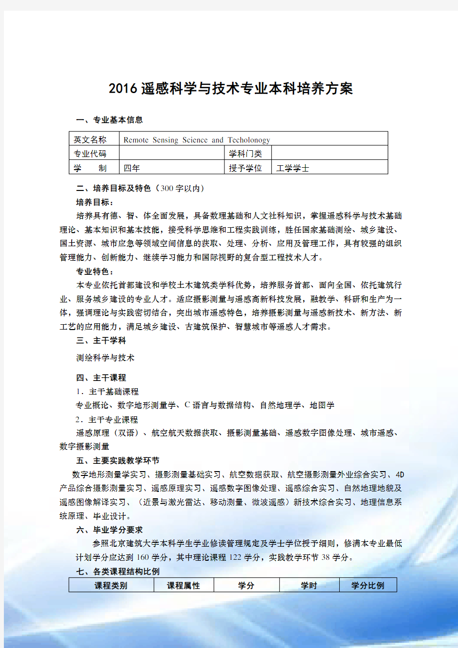
六、毕业学分要求
参照北京建筑大学本科学生学业修读管理规定及学士学位授予细则,修满本专业最低计划学分应达到160学分,其中理论课程122学分,实践教学环节38学分。
课程类别课程属性学分学时学分比例
通识教育课必修29.5 608 18.4
选修11.0 176 6.9 大类基础课必修49 852 30.6
选修 1 16 0.6 专业核心课必修14 224 8.7 专业方向课必修8 128 5
选修10.5 168 6.6 独立实践环节必修38 784 23.8 总计160 2956 100
学期教学周考试实践学期教学周考试实践1 4-16周17-18周19-20周 2 1-16周17-周18-20周3 1-15周16周17-20周 4 1-14周15-16周17-20周5 1-17周18周19-20周 6 1-16周17-18周19-20周7 7-14周15周1-6、16-20
周
8 1-16毕业设计/实习17周答辩毕业生应具备的知识能力相关知识领域实现途径(课程支撑)
理解马克思主义世界观、人生观和价值观的基本意义;了解国史国情,理解中国特色社会主义道路以及个人的责任;理解职业道德的含义和工程师的职业和责任职业规范:具有人文社会科学
素养、社会责任感,能够在工
程实践中理解并遵守工程职业
道德和规范,履行责任。
思想道德修养与法律基础、
中国近现代史纲要、马克思
主义基本原理概述、毛泽东
思想和中国特色社会主义
理论体系概论、军事理论、
形势与政策(1-2)
掌握计算机操作和信息管理的基本知识,具有程序设计和开发能力、了解软件体系架构、软件设计和开发的发展趋势计算机系统和软件开发等计算
机科学与技术基本理论
计算思维导论、C语言与数
据结构、面向对象程序设
计、可视化语言IDL等
掌握摄影测量的基本知识,具有运用航测相片进行空间信息获取能力、了解摄影测量技术的发展趋势摄影测量基础等基本理论航空航天数据获取、摄影测
量基础、数字摄影测量、近
景摄影测量、现代摄影测量
等
掌握遥感数据获取、数据处理的基本知识,具有利用遥感数据进行解译、行业应用遥感平台、载荷、数据处理及
信息提取等基本理论
航空航天数据获取、遥感原
理、遥感数字图像处理、遥
感技术应用、微波遥感、高
的能力,了解遥感技术的发
展趋势
光谱遥感等
能够理解一个多角色团队中每个角色的含义以及对整个团队环境和目标的意义;能够在团队中做好自己承担的角色,具备综合团队成员的意见并进行合理决策的能力。个人和团队:能够在多学科背
景下的团队中承担个体、团队
成员以及负责人的角色。
思想道德修养与法律基础、
军事理论、形势与政策
(1-2)、体育(1-4)、军
训、空间信息类综合实习
能够通过口头及书面方式表达自己的想法,掌握技术文件写作方法,理解和撰写效果良好的报告和设计文件,基本掌握一门外语,具有外语听说读写能力。沟通:能够就复杂工程问题与
业界同行及社会公众进行有效
沟通和交流,包括撰写报告和
设计文稿、陈述发言、清晰表
达或回应指令。并具备一定的
国际视野,能够在跨文化背景
下进行沟通和交流。
大学英语(1-2)、大学英
语拓展系列课程(1-8)、
科技文献检索、科技论文写
作、遥感原理(双语)、地
理信息系统原理(双语)
对于遥感技术的发展水平、所面临的挑战有正确认识;对于职业生涯规划和持续学习的必要性有正确认识,能够采用合适的方法通过学习不断发展自身的能力。终身学习:具有自主学习和终
身学习的意识,有不断学习和
适应发展的能力。
测绘地理信息概论、测绘地
理信息技术前沿、(近景与
激光雷达、移动测量、微波
遥感)新技术实习、毕业设
计、毕业答辩
十、指导性教学计划(见附表)
十一、主要课程逻辑关系结构图(见最后)
2016 Undergraduate Program for Specialty in Remote Sensing Science and Techolonogy
English Name Remote Sensing Science and Techolonogy
Code Disciplines
Length of Schooling Degree
II、Educational Objectives
Educational Objectives :Oriented by the country and capital urban and rural construction, the objective of education is to training the students to master the aviation and aerospace remote sensing theory, methods and techniques, with spatial information acquisition, processing, analysis, application ability. Students should be Multi-disciplinary compound talents on surveying and mapping and imagery information processing.
Specialty: Demanding by surveying and mapping and urban construction , relying on the advantages of School of architecture discipline, we highlight the aspects of long-term accumulation of theory and equipment advantages in photogrammetry and remote sensing of our school in the field of terrestrial lidar for ancient architectural heritage protection, refined urban management and the smart city, In the cultivation of students' ability, in each teaching link pay attention to "original ability", emphasize "programming ability". On the other hand, to ensure that students have the production capacity of photogrammetry remote sensing.
III、Major Disciplines
Science and technology of Surveying and mapping, geographic information science, computer science and technology.
IV、Major Courses
1 main basic courses
Professional introduction, digital topographic surveying, C language and data structure, geography, cartography
2 main courses
Remote sensing principle (Bilingual), aerospace data acquisition, photogrammetry, remote sensing digital image processing, urban remote sensing, digital photogrammetry
V、Major Practical Training
Digital topographic survey practice, basic photogrammetry practice, aviation data acquisition, field work practice of aerial photogrammetry control and annotation, 4D products integrated photogrammetric practice, practice of basic remote sensing, remote sensing digital image processing, remote sensing comprehensive practice, natural geography and remote sensing image interpretation practice, (close range and laser radar, mobile measurement, microwave remote sensing technology comprehensive practice, the principle of geographic information system, graduation design.
VI、Graduation Requirements
According to Beijing University of civil engineering and architecture undergraduate students studying management regulations and bachelor's degree granting rules, completed the professional plan minimum credits should reach 160 credits, the theoretical course of 115 credits, practice course of 45 credits.
Course Category Course Type Credits Class Hour Proportion
General Education Compulsory 29.5 608 18.4
Core 8 128 5
Optional 3 48 1.9 Big Academic Subjects Compulsory 49 852 30.6
Optional 1 16 0.6
Professional Core Compulsory 14 224 8.7 Professional Direction Compulsory 8 128 5
Optional 10.5 168 6.6 Practice Compulsory 38 784 23.8 Total 160 2956 100
Semester Teaching Exam Practice Semester Teaching Exam Practice
1 4-16 17-18 19-20
2 1-16 17 18-20
3 1-15 16 17-20
4 1-14 15-16 17-20
5 1-17 18 19-20
6 1-16 17-18 19-20
7 7-14 15 1-6、16-20 8 1-16graduation project 17defence IX、Table of Teaching Arrangement
Graduate Abilities Related Knowledge Course Supports
Understand the basic meanings of Marxist world outlook, outlook on life and values; understand history conditions, understanding the road of socialism with Chinese characteristics and personal responsibility; understanding ethical meaning and engineer career and responsibility Professional norms: with the
humanities and social science
literacy, social responsibility,
can be in engineering practice
to understand and abide by the
engineering ethics and norms,
fulfill their responsibilities.
Ideological and moral
cultivation and the legal
basis, Chinese modern
history outline, an overview
of the basic principles of
Marxism, Mao Zedong
Thought and the Chinese
characteristic socialism
introduction to the
theoretical system, military
theory, situation and policy
(1-2)
To master the basic knowledge of computer operation and information management, with the development of programming and development capabilities, understanding of software architecture, software design and development trends Basic theory of computer
science and technology, such as
computer system and software
development
Introduction to
computational thinking,
object oriented
programming, data structure,
visual language IDL, etc.
Master the basic knowledge of photogrammetry, with aerial photos of space information acquisition ability and understanding of the development trend of photogrammetry technology Basic theory of
Photogrammetry
Aerospace photogrammetry
data acquisition, digital
photogrammetry,
photogrammetry, close range
photogrammetry and modern
photogrammetry
Master the basic knowledge of remote sensing data acquisition, data processing, with the use of remote sensing data interpretation, the ability of remote sensing application in certain field and the development trend of remote sensing technology The basic theory of remote
sensing platform, sensors, data
processing and information
extraction.
Aerospace data acquisition,
remote sensing principle,
remote sensing digital image
processing, remote sensing
technology application,
microwave remote sensing,
High spectral remote
sensing, etc.
Can understand the meaning of a multi role teams for each role and the importance of the team environment and the target; in the team do assume their role, and rational decision-making ability with the opinion of the members of the team. Individuals and teams: be able
to take the role of individuals,
team members, and the person
in charge in a multidisciplinary
context.
ideological and moral
cultivation and legal basis,
military theory, situation and
policy (1-2), sports (1-4),
military training,
comprehensive practice of
spatial information
Through oral and written expression of ideas, to master the writing method of technical documents, understand and write good reports and design documents, basic grasp of a foreign language, with good English listening, speaking, reading and writing ability. Communication: be able to
communicate and communicate
effectively with industry
colleagues and the public in
complex engineering issues,
including writing reports and
design documents,
presentations, clear expression
or response instructions. And
have a certain international
vision, to be able to
communicate and exchange in
College English (1-2),
University English
Development Series (1-8),
science and technology
document retrieval, science
and technology paper
writing, remote sensing
principle (Bilingual),
geographic information
system (Bilingual)
the cross cultural context.
For the level of development of remote sensing technology and facing challenges have a correct understanding, for career planning and the necessity for continuous learning have correct understanding, to adopt appropriate methods by learning to develop their own capacity. Lifelong learning: a sense of
autonomous learning and
lifelong learning, and the ability
to continuously learn and adapt
to the development of.
Surveying and mapping
introduction to geographic
information, surveying and
mapping geographic
information technology
frontier, (close range
photohrammetry and laser
radar, mobile measurement,
microwave remote sensing)
new technology practice,
graduation design,
graduation reply
表1 遥感科学与技术专业指导性教学计划(1)
课程类别课
程
属
性
课程名称
学
分
总
学
时
讲
课
学
时
实
验
学
时
上
机
学
时
课
外
学
时
延
续
教
学
开课
学期
教学单位
通
识教育课必
修
思想道德修养与法律基础
Thought Morals Accomplishment and Basic
Law
3 48 32 16 1 马克思主义学院
中国近现代史纲要
The Outline of the Modern Chinese History
2 32 24 8 2 马克思主义学院
马克思主义基本原理概论★
The Generality of Basic Principle of
Marxism
3 48 32 16 5 马克思主义学院
毛泽东思想和中国特色社会主义体系理论概
论★
Introduction to Mao Zedong Thoughts and
Theoretical System of the Chinese
characteristic socialism
4 96 48 48 6 马克思主义学院
形势与政策(1-2)
Situation and Policy(1-2)
1 3
2 32 1、
3 马克思主义学院
大学生职业生涯与发展规划
College Student Occupation Career and
Development Planning
1 16 16 1 学工部
大学英语(1-2) ★
College English(1-2)
6 128 96 48 1、2 文法学院
大学英语拓展系列课程(1-4) 2 32 3 文法学院大学英语拓展系列课程(5-8) 2 32 4 文法学院体育(1-4)
Physical Education(1-4)
4 120 120 1-4 体育部
计算思维导论 1.5 24 32 1 电信学院小计29.5 608
核心经典赏析与文化传承 2 32 1-8 各院部哲学逻辑与文明对话 2 32 1-8 各院部科技精神与社会发展 2 32 1-8 各院部建筑艺术与审美体验 2 32 1-8 各院部生态文明与智慧城市 2 32 1-8 各院部至少修读4类合计8学分,每类至少修读2学分
选修
创新创业类1-8学期任选各院部
工程实践类1-8学期任选各院部
复合培养类1-8学期任选各院部
跨类任选至少3学分
通识教育课合计至少修读40.5学分,其中通识教育必修29.5学分,通识教育核心8学分,
通识教育任选3学分
表1 遥感科学与技术专业指导性教学计划(2)
课程类别课
程
属
性
课程名称
学
分
总
学
时
讲
课
学
时
实
验
学
时
上
机
学
时
课
外
学
时
延
续
教
学
开课
学期
教学单位
大类
基础课必
修
高等数学A(1)★
Advanced Mathematics A(1)
5 9
6 80 16 1 理学院
高等数学A(2)★
Advanced Mathematics A(2)
5 80 80 2 理学院
线性代数
Linear Algebra
2 40 32 8 2 理学院
概率与数理统计A
Theory of Probability and Statistics
3 4
4 4 3 理学院
普通物理A(1)★
College physics(1)
3 56 52
4 2 理学院
普通物理A(2)★
College physics(2)
3 56 52
4 3 理学院
物理实验(1-2)
Physics Experiment(1-2)
2 60 60 3-4 理学院
工程制图与视图Engineering Drawing 3 48 44 4 2 理学院C语言与数据结构C★ Programming
Language and Data Structure
3 48 32 16 1 地理信息科学系
自然地理学Physical geography 2 32 32 1 地理信息科学系测绘地理信息概论Introduction to
Geomatics
1 16 16 1 测绘学院
CAD基础与应用CAD Basic and Application 2 32 16 16 1 测绘工程系数字地形测量学★Digital Topographic
Surveying
4 64 52 12 2 测绘工程系
地图学Cartography 3 48 40 8 3 地理信息科学系
误差理论与测量平差基础★Fundamentals
of Error Theory and Surveying
Adjustment
3 48 48 3 测绘工程系地理信息系统原理(双语)The Principle of
Geographic Information System
3 48 40 8 3 地理信息科学系遥感原理 Principles of Remote Sensing 2 32 32 3 遥感工程系小计49 852 692 120 8 32
选修GIS基础应用技能 Gis Base Application
Skill
1 16 8 8
2 地理信息科学系
遥感应用前景 remote sensing
application prospect
1 16 8 8 3 遥感工程系
现代测绘技术应用 1 16 8 8 2 测绘工程系小计 3 48 24 24
大类学科基础课合计 50 学分,必修49 学分,选修 1学分
航空航天数据获取Aerospace data
acquisition
2 32 28 4 4 遥感工程系城市遥感(双语)Urban Remote Sensing
3 48 40 8 6 遥感工程系摄影测量基础Photogrammetry
Fundamental
3 48 4
4 4
5 遥感工程系
遥感数字图像处理Digital Image
Processing
3 48 40 8 5 遥感工程系数字摄影测量Digital Photogrammetry 3 48 40 8 6 遥感工程系小计1
4 224 192 32
专业核心课合计必修 14 学分
表1 遥感科学技术专业指导性教学计划(3)
课程类别课
程
属
性
课程名称
学
分
总
学
时
讲
课
学
时
实
验
学
时
上
机
学
时
课
外
学
时
延
续
教
学
开课
学期
教学单位
专
业方向课必
修
选
修
卫星导航定位技术Technology of
Satellite navigation and positioning
2 32 28 4 5 测绘工程系
面向对象程序设计 object oriented
programming
2 32 32 4 遥感工程系
激光雷达测量技术与应用Laser radar
Surveying Technology
2 32 24 8 6 遥感工程系
遥感技术应用Applications of Remote
Sensing
23216 16 6遥感工程系
小计8128100 28
近景摄影测量Close Range Photogrammetry 2 32 26 6 6 遥感工程系微波遥感Microwave Remote Sensing 2 32 32 5 遥感工程系移动道路测量技术及应用Technology and
Application of Mobile Mapping System
1 16 8 8 7 地理信息科学系
现代摄影测量Modern Photogrammetry 2 32 32 7 遥感工程系
大地测量基础Geodesy Fundamental 2 32 24 8 4 测绘工程系高光谱遥感Hyperspectral remote sensing 2 32 6 遥感工程系
科技论文写作(双语)Academic Writing
(Billinguish)
11616 6遥感工程系科技文献检索document retrieval of
science and technology
1 24 16 8 5 图书馆
测绘地理信息技术前沿Advanced
Technology of
1 16 16 7 测绘学院
智慧城市导论Introduction to smart city 1 16 16 6 地理信息科学系遥感软件Remote Sensing Software 2 32 16 16 4 遥感工程系GIS软件使用 GIS Software 2 32 16 16 4 地理信息科学系可视化语言IDL The Language IDL 2 32 16 16 6 遥感工程系
小计21304234 70
要求选修10.5学分
表2 测绘工程专业指导性教学计划(实践环节)
课
程属性课程名称
学
分
折
合
学
时
实
验
实
践
上
机
开课
学期开设
周次
教学单位
课内军事理论
Military Theory
1 3
2 32
1 1-3 武装部
军训
Military Training
1 3
2 32
数字地形测量实习Digital Topographic
Surveying Practice
3 60 60 2 18-20 测绘工程系地图学实习Cartography Practice 2 40 40 3 17-18
地理信息科学
系
摄影测量基础实习Photogrammetry
Fundamental Practice
1 20 20 5 19 遥感工程系
地理信息系统原理The Principle of Geographic Information System Practice 2 40 40 3 19-20
地理信息科学
系
遥感数字图像处理Digital Image Processing
Practice
1 20 20 5 20 遥感工程系航空航天数据获取Aerospace data Acquisition
Practice
1 20 20 4 18 遥感工程系空间信息综合实习Spatial Information
Practice
6 120 120
7 1-6 测绘学院遥感综合实习Remote Sensing Comprehensive
Practice
3 60 60 7 18-20 遥感工程系遥感原理实习Principles and Applications
of Remote Sensing Practice
1 20 20 4 17 遥感工程系自然地理地貌及遥感图像解译实习Natural
geography and remote sensing image interpretation Practice 2 20 20 6 19-20
遥感工程系
(近景与激光雷达、移动测量、微波遥感)新技
术实习New technology Practice 2 40 40 7 16-17
遥感工程系、地
理信息科学系
面向对象程序设计实习Object oriented
programming Practice 2 40 40 4 19-20
地理信息科学
系
毕业设计Undergraduate Design or Thesis8 320 320 8 1-16 遥感工程系小计36 744 744
课
外
创新实践及科
研训练遥感科学与技术创新实践及科研
训练
2 40 40 遥感工程系
小计38 784 784
实践环节合计38 学分,其中课内36 学分,课外 2 学分(创新实践及科研训练必修2学分)