INTEGRATION OF LOCAL AREA AUGMENTATION SYSTEM AND INERTIAL NAVIGATION SYSTEM FOR AIRCRAFTsurFACE MOV
关于整形的英文介绍,不得不看哦Plastic surgery

• In 1465, Sabuncuoglu's book, description, and classification of hypospadias was more informative and up to date. Localization of urethral meatus was described in detail. Sabuncuoglu also detailed the description and classification of ambiguous genitalia.[citation needed] common.
• Up until the techniques of anesthesia(麻 醉) became established, surgeries involving healthy tissues involved great pain. Infection from surgery was reduced by the introduction of sterile techniques and disinfectants. The invention and use of antibiotics, beginning with sulfa drugs and penicillin, was another step in making elective surgery possible.
The first American plastic surgeon was John Peter Mettauer, who, in 1827, performed the first cleft palate operation with instruments that he designed himself. In 1845, Johann Friedrich Dieffenbach wrote a comprehensive text on rhinoplasty, entitled Operative Chirurgie, and introduced the concept of reoperation to improve the cosmetic appearance of the reconstructed nose.
计算机常用术语英文缩写

AAAL ATM Adapter Layer ATM适配层ABC Automatic Brightness Control 自动亮度控制ACM Association for Computing Machinery 美国计算机协会ADC Analog-to-Digital Convener 模数转换器ADO ActiveX Data Objects 动态数据对象ADP Automatic Data Processing 自动数据处理ADPCM Adaptive Digital Pulse Code Modulation 自适应数字脉冲编码调制ADSL Asymmetrical Digital Subscriber Loop 非对称数字用户环路AGP Accelerated Graphics Port 加速图形端口AI Artificial Intelligence 人工智能ANSI American National Standard Institute 美国国家标准协会AOL American On Line 美国在线API Application Program Interface 应用程序接口APM Advanced Power Management 高级电源管理ARC Augmentation Research Center 扩大研究中心ARP Address Resolution Protocol 地址解析协议ARPA Advanced Research Project Agency 远景研究规划局ARQ Automatic Repeat Request 自动重复请求ASCII American Standard Code for Information Interchange 美国信息交换标准代码ATM Asynchronous Transfer Mode 异步传输模式AVI Audio Video Interleaved 一种Windows的多媒体文件格式AWT Abstract Windows Toolkit 抽象窗口工具库BB5 Big-5 大五(码)BASIC Beginner's All-purpose Symbolic Instruction Code 初学者的通用符号指令码(基础语言)BBS Bulletin Board System (电子)公告板系统BCC Blind Courtesy Copy (电子邮件)盲式副本BFT Binary File Transfer 二进制文件传输B-ISDN Broadband ISDN 宽带ISDNBISYNC Binary Synchronous Communications Protocol 二进制同步通信协议BMP Bitmap 位图BOF Birds Of Feather 专题讨论小组bps bits per second 位每秒BRI Basic Rate Interface 基本速率接口BSC Binary Synchronization Communication 二进制同步通信规程CC/S Client/Server 客户机/服务器CA Certificate Authority 证书机构CAD Computer Aided Design 计算机辅助设计CAI Computer Aided Instruction 计算机辅助教学CAM Computer Aided Manufacturing 计算机辅助制造CASE Computer Aided Software Engineering 计算机辅助软件工程CAT Computer Aided Testing 计算机辅助测试CBT Computer-Based Training 基于计算机的训练CC Courtesy Copy (电子邮件)副本CCCII Chinese Character Code for Information Interchange 汉字信息交换码CCITT Consultative Committee for International Telegraph and Telephone 国际电报电话咨询委员会CD Carrier Detect 载波侦听CD Compact Disc 光盘CDDI Copper Distributed Data Interface 铜线分布式数据接口CD-E Compact Disc-Erasable 可擦除光盘CD-I Compact Disc-Interactive 互动式光盘CD-R Compact Disc-Recordable 可录光盘CD-ROM Compact Disc-Read Only Memory 只读光盘CD-RW Compact Disc-Rewritable 可重写光盘CERN European Laboratory for Particle Physics 欧洲粒子物理实验室CERNET China Education and Research Network 中国教育科研网CERT Computer Emergency Response Team 计算机紧急情况反应小组CGI Common Gateway Interface 通用网关界面CGI Computer Graphic Interface 计算机图形接口China DDN 中国公用数字数据网China PAC 中国公用数据网CIM CompuServe Information Manager 一种CompuServe的图形界面程序CIM Computer Input Microfilm 计算机输入缩微胶卷CISC Complex Instruction Set Computer 复杂指令集计算机CIX Commercial Internet Exchange 商务因特网交换中心(连接点)CMI Computer Managed Instruction 计算机管理教学CMOS Complementary Metal Oxide Semiconductor 互补金属氧化物半导体CMYK Cyan Magenta Yellow Black 青色、洋红、黄色、黑色CO/DEC Coding and Decoding 编码/解码COA Certificate Of Authenticity 真品证书COM Component Object Model 组建对象模型Cps characters per second 字符每秒钟CPU Central Processing Unit 中央处理器CRC Cyclical Redundancy Check 循环冗余检验CREN Corporation for Research and Educational Networking 研究与教学连网组织CS Convergence Sub layer 传输会聚子层CSCW Computer Supported Cooperative Work 计算机支持的协同工作CSMA/CD Carrier Sense Multiple Access with Collision Detection 载波侦听多址访问/冲突检测CSNet Community Service Network 社区服务网络CSNET Computer and Science Network 计算机与科学网络CSO Computing Services Office 计算机服务机构CSS Cascading Style Sheets 级联样式表CTI Computer Telephony Integration 计算机电话集成CTS Clear To Send 清除发送DDAC Digital-to-Analog Convener 数模转换器DARPA Define Advanced Research Projects Agency of the Department of Defense (美国)国防高级研究计划局DB Database 数据库DCE Data Communication Equipment 数据通信设备DDE Dynamic Data Exchange 动态数据交换DDN Digital Data Network 数字数据网络DEN Directory Enabled Network 目录驱动网络DES Data Encryption Standard 数据加密标准DHCP Dynamic Host Configuration Protocol 动态主机配置协议DHTML Dynamic Hyper Text Makeup Language 动态超文本标记语言DIMM Double In-Line Memory Module (168线内存插槽)DIS Distributed Interactive Simulation 分布式交互仿真DIX 数据链路层和物理层规范,也称DIX规范DIY Do It Yourself 自己动手DL Data Link 数据链路DLL Dynamic Link Library 动态链接库DMA Direct Memory Access 直接存储器存取DMI Desktop Management Interface 桌面管理界面DNIC Data Netwrok Indentifier Code 数据网络识别码DNS Domain Naming System 域名系统DNS Digital Nervous System 数字神经系统DNS Domain Name Server 域名服务器DNS Domain Name System 域名系统DOM Document Object Model 文档对象模型DOS Disk Operating System 磁盘操作系统dpi dots per inch 点每英寸DRAM Dynamic Random Access Memory 动态随机存取存储器DSL Data Set Label 数据集标号DSL Digital Subscriber Line 数字用户线路DSP Digital Signal Processing 数字信号处理DSP Digital Signal Processor 数字信号处理器DSR Data Set Ready 数据准备就绪DTD Document Type Definition 文档类型定义DTE Data Terminal Equipment 数据终端设备DTR Data Terminal Ready 数据终端就绪DU Data Unit 数据单元DVD Digital Video Disc 数字影像光盘DVR Distributed Virtual Reality 分布式虚拟现实DXI Data Exchange Interface 数据交换接口EE1 支持32路PCM载波信号的欧洲PCM 载波标准EACC East Asian Character Code 东亚字码ECC Error Checking and Correcting 错误侦测校正ECP Extended Capabilities Port 扩展端口ECPA Electronic Communications Privacy Act 电子通信保密法EDI Electronic Data Interchange 电子数据交换EDO Extended Data Out 扩展数据输出EDP Electronic Data Processing 电子数据处理EGA Enhanced Graphic Adapter 增强图像适配器EIA Electronic Industries Association 电子工业协会EIDE Enhanced Integrated Devices Electronics 增强型综合电器界面EISA Enhanced Industry Standard Architecture 增强型工业标准结构E-mail Electronic-mail 电子邮件EMS Extended Memory Specification 扩展内存规范EOT End Of Transmission 传输结束EPP Enhanced Parallel Port 增强型并行端口EPROM Erasable Programmable Read Only Memory 可擦可编程只读存储器ESD Electronic Software Distribution 电子软件分发ESDI Enhanced Small Device Interface 增强小型设备接口FFAQ Frequently Asked Question 常见问题FAQL Frequently Ask Question List 常见问题列表FAT File Allocation Table 文件分配表FD Floppy Disk 软盘FD Full Duplex 全双工FDC Floppy Disk Connector 软盘连接器FDD Floppy Disk Drive 软盘驱动器FDDI Fiber Distributed Data Interface 光纤分布数据接口FDM Frequency Division Multiplexing 频分多路复用FPE Fix People Expert 整人专家(软件)FPM Fast Page Mode 快速页模式FR Frame Relay 帧中继FSB Front-Side Bus 前端总线FTAM File Transfer Access and Management 文件传输访问与管理FTP File Transfer Protocol 文件传送协议FYI For Your Information 用户信息GGb GigaBit 千兆位GB GigaByte 千兆字节GB Guo Biao 国标GBK Guo Biao Kuozhan 国标扩展(码)GDI Graphic Device Interface 图形设备接口GIF Graphic Interchange Format 图型交换格式GIP Global Internet Project 全球因特网计划(联盟)GML Generalized Markup Language 通用标记语言GPS Global Positioning System 全球定位系统GSM Global Standard for Mobile Communication 全球移动通信系统GUI Graphic User Interface 图形用户界面HHD Half Duplex 半双工HD High Density 高密HD Hard Disk 硬盘HDC Hard Disk Connector 硬盘连接器HDD Hard Disk Drive 硬盘驱动器HDLC High-level Data Link Control 高级数据链路控制HDTV High Density Television 高密度电视HEX Hexadecimal 十六进制HGA Hercules Graphic Adapter 大力士显示适配器HPC Handheld Personal Computer 手持个人电脑HPPI High Performance Parallel Interface 高性能并行接口HTML Hyper Text Makeup Language 超文本标记语言HTTP Hypertext Transfer Protocol 超文本传输协议HTTP-NG Hyper Text Transfer Protocol-Next Generation 下一代超文本传送协议HUB 集线器Hz Hertz 赫兹IIBM International Business Machines 国际商业机器(公司)IC Integrated Circuit 集成电路ICMP Internet Control Message Protocol 因特网控制消息协议ICP Internet Content Provider 因特网内容提供者ICQ I Seek You 网上寻呼IDE Integrated Devices Electronics 综合电器界面IDF Intel Developer Forum 英特尔开发者论坛IDG International Data Group 国际数据组织IDSL Internet Digital Subscriber Line 因特网数字用户线路IDU Interface Data Unit 接口数据单元IE Internet Explorer (微软)因特网浏览器IEEE Institute of Electrical and Electronic Engineers 电机及电子工程师协会IFF Interchange File Format 文件交换格式IIS Internet Information Server 因特网信息服务器IP Internet Protocol (因特网)网间通信协议IPC Industrial PC 工业控制微机IPX Internet work Packet exchange 因特网络分组交换IRC Internet Relay Chat 网上实时聊天IRQ Interrupt Request (Line) 中断请求(线路)ISA Industry Standard Architecture 工业标准体系结构(AT总线) ISDN Integrated Services Digital Network 综合业务数字网ISM Internet Server Manager 因特网服务管理器ISO International Standardization Organization 国际标准化组织ISOC Internet Society 因特网协会ISP Internet Service Provider 因特网服务提供者ISV Independent Software Vendor 独立软件供应商IT Information Technology 信息技术JJDK Java Development Kit Java语言开发工具包JPEG Joint Photographic Experts Group 联合照相专家组JVM Java Virtual Machine Java虚拟机KKB Keyboard 键盘KB Kilobit 千位KB Kilobyte 千字节Kbps Kilobits per second 千位每秒KDD Knowledge Discovery in Database 数据库中的知识发现LLAN Local Area Network 局域网LANE Local Area Network Emulation 局域网仿真LAP-M Link Access Procedure for Modems 调制解调器连接访问协议LC Logical Circuit 逻辑链路LCD Liquid Crystal Display 液晶显示LD Laser Disc 激光碟LDAP Lightweight Directory Access Protocol 简单的目录访问协议LDCM LANDesk Client Manager 终端客户管理程序LEC LAN Emulation Client 局域网仿真客户LES LAN Emulation Server 局域网仿真服务器LLC Logical Link Control 逻辑链路控制Lpi lines per inch 行每英寸LPT Line Print 行式打印机(并行)端口MMAC Medium Access Control 媒体访问控制MAC Macintosh 麦金塔(计算机)MAN Metropolitan Area Network 城域网MAPI Messaging Application Programming Interface 通信应用程序接口MAU Multiple Access Unit 多路访问器Mb MegaBit 兆位MB MegaByte 兆字节Mbone Multicast Backbone 多播主干网MCA Micro Channel Architecture 微通道结构MCGA MultiColor Graphics Array 彩色图形阵列MCI Media Control Interface 媒体控制接口MDA Monochrome Display Adapter 单色显示适配器MDI Multiple Document Interface 媒体相关接口MIDI Musical Instrument Digital Interface 乐器数字化接口MIME Multipurpose Internet Mail Extensions 多用途因特网邮件扩充MIPS Millions of Instructions Per Second 百万词条指令每秒钟MLP Multiple Link Protocol 多链路规程MMM Mobile Media Mode 移动媒体模式MMX Multimedia Xtension 多媒体扩展指令集MO Magneto Optical (Disc) 磁介质光盘MODEM Modulator-Demodulator 调制解调器MOTD Message Of The Day 每日邮件MOTSS Members Of The Same Sex 同性别会员MPEG Motion Picture Expert Group 动态影像压缩标准MPOA MultiProtocol Over ATM ATM上的多协议MPR 瑞典国家计量和测试机构MS Microsoft 微软(公司)MSN Microsoft Network 微软网络MTBF Mean Time Between Failures 平均失效间隔时间MTTR Mean Time To Repair 平均修复时间MUD Multiple Users Dialogue (Dungeons) 多用户对话(泥巴网络地牢游戏)NNAK Negative Acknowledge 否认NAT Network Address Translation 网址解析NC Network Computer 网络计算机NCSA National Center for Supercomputing Applications (美国)国家超级计算应用中心NFS Network File System 网络文件系统NIC Network Information Center 网络信息中心NIC Network Interface Card 网卡N-ISDN Narrowband ISDN 窄带ISDNNMC Network Manager Center 网络管理中心NMS Network Management System 网络管理系统NNI Network-Network Interface 网络/网络端接口NNTP Network News Transport Protocol 网络新闻传输协议NOC Network Operations Center 网络操作中心NREN National Research and Education Network 国家研究与教育网NRNI 不归0交替编码NSF National Science Foundation 国家科学基金会NT Network Terminal 网络终端NT New Technology 新技术NTFS NT File System (微软)NT文件系统NTLM NT LanMan WindowsNT 挑战与响应验证协议NTSC National Television Standard Committee 国家电视标准委员会OOA Office Automation 办公自动化OCR Optical Character Recognition 光学扫描字符识别OCT Octal 八进制ODB Output to Display Buffer 显示输出缓存ODBC Open Database Connectivity 开放的数据库连接OEM Original Equipment Manufacture 初始设备制造商OH Off Hook (调制解调器)摘机OLCR Online Character Recognition 在线手写识别OLE Object Linking and Embedding 对象链接与嵌入OLTP Online Transaction Processing 联机事务处理ONE Open Network Environment 开放网络环境OPAC Online Public Access Catalog 在线公共检索目录OS Operating System 操作系统OSD On Screen Display 屏幕显示(菜单)OSI Open System Interconnection 开放系统互连OSP Online Service Provider 在线服务提供商PPAD Packet Assembler Disassemble 包装、拆卸设备PAP Password Authentication Protocol 密码认证协议PC Personal Computer 个人计算机PCB Printed Circuit Board 印刷电路板PCI Protocol Control Information 协议控制信息PCI Peripheral Component Interconnect 外围设备互连PCM Pulse Code Modulation 脉码调制PCMCIA Personal Computer Memory Card International Association (个人计算机存储卡国际协会)PDA Personal Digital Assistant 个人数字助理PDF Portable Document Format 可移植文档格式PDH 准同步数字体系PDU Protocol Data Unit 协议数据单元PERL Practical Extraction and Reporting Language 实际抽取报告语言PGP Pretty Good Privacy 高度保密PICS Platform for Internet Content Selection 因特网内容检索平台PM Physical Medium 物理媒体子层PnP Plug and Play 即插即用POP Post Office Protocol 邮局协议PPC Palm Personal Computer 掌上个人电脑Ppm pages per minute 页每分钟PPP Point to Point Protocol 点对点协议PPTP Point to Point Tunneling Protocol 点对点通道协议PRI Primary Rate Interface 一次群速率接口PROM Programmable Read Only Memory 可编程只读存储器PSDN Packet Switched Data Network 分组交换数据网PSE Packet Switched Equipment 分组交换设备PSN Packet Switching Network 包交换网络PSN Packet Switching Node 包交换节点PSTN Public Switched Telephone Network 公用交换电话网PVC Permanent Virtual Circuit 永久虚电路QQoS Quality of Service 服务质量QTAM Queued Telecommunications Access Method 排队远程通信访问方法RR&D Research and Development 研究与发展RAID Redundant Arrays of Inexpensive Disks 磁盘冗余阵列RAM Random Access Memory 随机存储器RARP Reverse Address Resolution Protocol 逆向地址解析协议RDBMS Relational Database Management System 关系数据库管理系统RDF Resource Description Framework 资源描述结构RFC Request For Comments 请求评议(文档)RGB Red Green Blue 红绿蓝RISC Reduced Instruction Set Computer 精简指令集计算机RJ Registered Jack 标准插座ROM Read Only Memory 只读存储器RPG Roles Play Games 角色扮演游戏RPU 环中继转发器RTS Request To Send 发送请求SSAR Segmentation and Reassembly sub layer 分段、组装子层SCSI Small Computer System Interface 小型计算机系统接口SDH Synchronous Digital Hierarchy 同步数字体系SDK Software Development Kit 软件开发工具包SDLC Synchronous Data Link Control 同步数字体系SDRAM Synchronous Dynamic Random Access Memory 同步动态随机存取存储器(同步内存)SDU Service Data Unit 服务数据单元SET Secure Electronic Transaction 安全电子交易SGML Standard Generalized Makeup Language 标准普及标识语言SHTTP Secure Hyper Text Transfer Protocol 安全超文本传送协议SIMM Single In-Line Memory Module (72线内存插槽)SLIP Serial Line Internet Protocol 串列线路网际协议SLP Single Link Protocol 单链路规程SMDS Switched Multimegabit Data Service 多兆位数据交换业务SMIL Synchronize Multimedia Integration Language 同步多媒体集成语言SMP Symmetric Multiprocessing 对称多任务处理SMTP Simple Mail Transfer Protocol 简单邮件传输协议SMTP Simple Mail Transfer Protocol 简单邮件传输协议SNA Systems Network Architecture 系统网络体系结构SNMP Simple Network Management Protocol 简单网络管理协议SOHO Small Office / Home Office 小型/家庭办公SONET Synchronous Optical Network 同步光纤网SPP Standard Parallel Port 标准并行端口SQL Structured Query Language 结构化查询语言SRAM Static Random Access Memory 静态随机存取存储器SSD Solid-State Disk 固态盘SSL Secure Sockets Layer 安全套接层STD Suspend to Disk 悬挂于磁盘STP Shielded Twisted Pair 屏蔽双绞线STR Suspend to Ram 悬挂于内存SVC Switched Virtual circuit 交换虚电路SVGA Super Video Graphics Array 超级影像阵列TT1 支持24路PCM载波信号的美洲PCM 标准Tb TeraBit 太位TB TeraByte 太字节TC Transmission Convergence 传输会聚子层TCO 瑞典专业职业联盟TCP Transfer Control Protocol 传输控制协议TCP/IP Transmission Control Protocol / Internet Protocol 传输控制协议/网间通信协议TDM Time Division Multiplexing 时分多路复用TFTP Trivial File Transfer Protocol 次要文件传输协议TIA Telecommunication Industries Association 电信工业协会TIFF Tag Image File Format 标签式图像文件格式Token-BUS 令牌总线TRON The Real-time Operating-system Nucleus 实时操作系统中枢TSMU Time-Sharing Multi-Use 分时多用户TSR Terminate and Stay Resident 驻留程序TTY Teletypewriter 电传打字机UUDP User Datagram Protocol 用户数据报协议UDP User Datagram Protocol 用户数据报协议UDT Uniform Data Transfer 一致性数据传输UMA Upper Memory Area 上位内存区UMB Upper Memory Block 上位内存快UNI User Network Interface 网络用户端接口UPS Uninterruptible Power Supply 不间断电源URL Universal Resource Locator 资源统一定位符USB Universal Serial Bus 通用串行总线UTP Unshielded Twisted Paired 非屏蔽双绞线UUCP UNIX-to-UNIX Copy UNIX到UNIX的复制VVAN Value-Added Network 增值网VC Virtual Circuit 虚通道VCD Video Compact Disc 影碟VCI Virtual Channel Indicate 虚拟通道标志VDSL Very-high-rate Digital Subscriber Line 超高速数字用户线路VESA Video Electronics Standards Association 视频电子标准协会(VL总线) VGA Video Graphics Array 影像阵列VI Virtual Interface 虚拟接口VLAN Virtual Local Area Network 虚拟局域网络VLDB Very Large Database 超大型数据库VON Voice On the Net 网络语音VPI Virtual Path Indicate 虚拟路径标志VPN Virtual Private Network 虚拟专用网VR Virtual Reality 虚拟现实VRAM Video Random Access Memory 视频随机存储器VRML Virtual Reality Makeup Language 虚拟现实标记语言VRML Virtual Reality Modeling Language 虚拟现实建模语言VT Virtual Terminal 虚拟终端WW3C World Wide Web Consortium 世界范围网联盟WAIS Wide Area Information Service 广域信息服务系统WAN Wide Area Network 广域网WAP Wireless Application Protocol 无线应用协议WBEM Web-Based Enterprise Management 基于Web的企业管理WDM Wavelength Division Multiplexing 波分多路复用Wintel Windows + Intel 微软、英特尔(联盟)WWW World Wide Web 万维网WYSIWYG What You See Is What You Get 所见即所得XX.25 由CCITT提出的DTE至DCE间的接口协议XLL eXtensible Link Language 可扩展链接语言XML eXtensible Markup Language 可扩展标记语言XMS eXtended Memory Specification 扩充内存规范XSL eXtensible Style Language 可扩展样式语言YY2K Year 2000 2000年问题。
GPS相关英文缩写

HV - Host Vehicle 主机
ICAO - International Civil Aviation Organization 国际民航组织
ICD - Interface Control Document 界面控制文件
ICS - Internal Communication System 内部通信联络系统
A-C
D-F
G-M
N-S
D-F
DAC - Digital to Analog Converter —— 模拟/数字信号转换器 DB - Decibel (X = 10 LogX dB) —— 分贝 DGPS - Differential GPS —— 差分 GPS DLM - Data Loader Module —— 数据装载模块 DLR - Data Loader Receptable —— 数据装载接收器 DLS - Data Loader System —— 数据装载系统 DMA - Defense Mapping Agency —— 国防制图局 DME - Distance Mesurement Equipment —— 测距设备 DoD - Department of Defense —— 美国国防部 DOP - Dilution of Precision —— 精度因子 DRMS —— 二维均方根 DRS - Dead Reckoning System —— 推测航行系统 DSP - Digital Signal Processing —— 数字信号处理 DT&E - Development Test and Evaluation —— 测试评估发展 DTK - Desired Track —— 期望航向(从起点到终点的路线) ECEF - Earth Centered Earth Fixed —— 地固地心直角坐标系 ECP - Engineering Change Proposal —— 工程更改建议 EDM - Electronic Distance Measurement —— 电子测距 EFIS - Electronic Flight Instrument System —— 电子飞行仪器系统 EM - Electro Magnetic —— 电磁 EMCON - Emission Control —— 发射控制 EPE - Estimated Position Error —— 估计位置误差
GNSS地基增强系统研究及应用综述

GNSS地基增强系统研究及应用综述慕阳【摘要】The-Ground-Based-Augmentation-System-(GBAS)-is-called-the-Local-Area-Augmentation-System-(LAAS)-by-FAA.-The-LAAS-ground-facility-(LGF)-performs-the-pseudo-range-carrier-smoothing-and-the-integrity-monitoring.-It-produces-the-pseudo-range-correction-and-broadcasts-the-differential-message.-The-airborne-system-users-can-receive-GBAS-signals-to-perform-pseudo-range-differential-position-and-approach-guidance.-This-article-focuses-mainly-on-the-components-of-GBAS,-its-working-principles,-the-technological-research-survey-and-application-prospect.-The-application-of-GBAS-in-the-area-of-civil-aviation-will-achieve-considerable-direct-or-indirect-economic-and-social-benefits.%地基增强系统地面站进行载波平滑伪距,进行完好性监测,产生伪距校正信息,并广播差分信息报文,机载用户接收GBAS信号进行伪距差分定位,完成进近引导。
本文主要介绍了GBAS系统的系统组成、工作原理、技术研究概况及应用前景,GBAS系统在民航领域的应用,将取得非常可观的直接、间接经济效益和社会效能。
Simultaneous localization and mapping (SLAM) part II

S
long excursion, the so-called loop-closure problem. The data association section surveys current data association methods used in SLAM. These include batch-validation methods that exploit constraints inherent in the SLAM formulation, appearance-based methods, and multihypothesis techniques. The third development discussed in this tutorial is the trend towards richer appearance-based models of landmarks and maps. While initially motivated by problems in data association and loop closure, these methods have resulted in qualitatively different methods of describing the SLAM problem, focusing on trajectory estimation rather than landmark estimation. The environment representation section surveys current developments in this area along a number of lines, including delayed mapping, the use of nongeometric landmarks, and trajectory estimation methods. SLAM methods have now reached a state of considerable maturity. Future challenges will center on methods enabling large-scale implementations in increasingly unstructured environments and especially in situations where GPS-like solutions are unavailable or unreliable: in urban canyons, under foliage, under water, or on remote planets.
Modeling the Spatial Dynamics of Regional Land Use_The CLUE-S Model

Modeling the Spatial Dynamics of Regional Land Use:The CLUE-S ModelPETER H.VERBURG*Department of Environmental Sciences Wageningen UniversityP.O.Box376700AA Wageningen,The NetherlandsandFaculty of Geographical SciencesUtrecht UniversityP.O.Box801153508TC Utrecht,The NetherlandsWELMOED SOEPBOERA.VELDKAMPDepartment of Environmental Sciences Wageningen UniversityP.O.Box376700AA Wageningen,The NetherlandsRAMIL LIMPIADAVICTORIA ESPALDONSchool of Environmental Science and Management University of the Philippines Los Ban˜osCollege,Laguna4031,Philippines SHARIFAH S.A.MASTURADepartment of GeographyUniversiti Kebangsaan Malaysia43600BangiSelangor,MalaysiaABSTRACT/Land-use change models are important tools for integrated environmental management.Through scenario analysis they can help to identify near-future critical locations in the face of environmental change.A dynamic,spatially ex-plicit,land-use change model is presented for the regional scale:CLUE-S.The model is specifically developed for the analysis of land use in small regions(e.g.,a watershed or province)at afine spatial resolution.The model structure is based on systems theory to allow the integrated analysis of land-use change in relation to socio-economic and biophysi-cal driving factors.The model explicitly addresses the hierar-chical organization of land use systems,spatial connectivity between locations and stability.Stability is incorporated by a set of variables that define the relative elasticity of the actual land-use type to conversion.The user can specify these set-tings based on expert knowledge or survey data.Two appli-cations of the model in the Philippines and Malaysia are used to illustrate the functioning of the model and its validation.Land-use change is central to environmental man-agement through its influence on biodiversity,water and radiation budgets,trace gas emissions,carbon cy-cling,and livelihoods(Lambin and others2000a, Turner1994).Land-use planning attempts to influence the land-use change dynamics so that land-use config-urations are achieved that balance environmental and stakeholder needs.Environmental management and land-use planning therefore need information about the dynamics of land use.Models can help to understand these dynamics and project near future land-use trajectories in order to target management decisions(Schoonenboom1995).Environmental management,and land-use planning specifically,take place at different spatial and organisa-tional levels,often corresponding with either eco-re-gional or administrative units,such as the national or provincial level.The information needed and the man-agement decisions made are different for the different levels of analysis.At the national level it is often suffi-cient to identify regions that qualify as“hot-spots”of land-use change,i.e.,areas that are likely to be faced with rapid land use conversions.Once these hot-spots are identified a more detailed land use change analysis is often needed at the regional level.At the regional level,the effects of land-use change on natural resources can be determined by a combina-tion of land use change analysis and specific models to assess the impact on natural resources.Examples of this type of model are water balance models(Schulze 2000),nutrient balance models(Priess and Koning 2001,Smaling and Fresco1993)and erosion/sedimen-tation models(Schoorl and Veldkamp2000).Most of-KEY WORDS:Land-use change;Modeling;Systems approach;Sce-nario analysis;Natural resources management*Author to whom correspondence should be addressed;email:pverburg@gissrv.iend.wau.nlDOI:10.1007/s00267-002-2630-x Environmental Management Vol.30,No.3,pp.391–405©2002Springer-Verlag New York Inc.ten these models need high-resolution data for land use to appropriately simulate the processes involved.Land-Use Change ModelsThe rising awareness of the need for spatially-ex-plicit land-use models within the Land-Use and Land-Cover Change research community(LUCC;Lambin and others2000a,Turner and others1995)has led to the development of a wide range of land-use change models.Whereas most models were originally devel-oped for deforestation(reviews by Kaimowitz and An-gelsen1998,Lambin1997)more recent efforts also address other land use conversions such as urbaniza-tion and agricultural intensification(Brown and others 2000,Engelen and others1995,Hilferink and Rietveld 1999,Lambin and others2000b).Spatially explicit ap-proaches are often based on cellular automata that simulate land use change as a function of land use in the neighborhood and a set of user-specified relations with driving factors(Balzter and others1998,Candau 2000,Engelen and others1995,Wu1998).The speci-fication of the neighborhood functions and transition rules is done either based on the user’s expert knowl-edge,which can be a problematic process due to a lack of quantitative understanding,or on empirical rela-tions between land use and driving factors(e.g.,Pi-janowski and others2000,Pontius and others2000).A probability surface,based on either logistic regression or neural network analysis of historic conversions,is made for future conversions.Projections of change are based on applying a cut-off value to this probability sur-face.Although appropriate for short-term projections,if the trend in land-use change continues,this methodology is incapable of projecting changes when the demands for different land-use types change,leading to a discontinua-tion of the trends.Moreover,these models are usually capable of simulating the conversion of one land-use type only(e.g.deforestation)because they do not address competition between land-use types explicitly.The CLUE Modeling FrameworkThe Conversion of Land Use and its Effects(CLUE) modeling framework(Veldkamp and Fresco1996,Ver-burg and others1999a)was developed to simulate land-use change using empirically quantified relations be-tween land use and its driving factors in combination with dynamic modeling.In contrast to most empirical models,it is possible to simulate multiple land-use types simultaneously through the dynamic simulation of competition between land-use types.This model was developed for the national and con-tinental level,applications are available for Central America(Kok and Winograd2001),Ecuador(de Kon-ing and others1999),China(Verburg and others 2000),and Java,Indonesia(Verburg and others 1999b).For study areas with such a large extent the spatial resolution of analysis was coarse(pixel size vary-ing between7ϫ7and32ϫ32km).This is a conse-quence of the impossibility to acquire data for land use and all driving factors atfiner spatial resolutions.A coarse spatial resolution requires a different data rep-resentation than the common representation for data with afine spatial resolution.Infine resolution grid-based approaches land use is defined by the most dom-inant land-use type within the pixel.However,such a data representation would lead to large biases in the land-use distribution as some class proportions will di-minish and other will increase with scale depending on the spatial and probability distributions of the cover types(Moody and Woodcock1994).In the applications of the CLUE model at the national or continental level we have,therefore,represented land use by designating the relative cover of each land-use type in each pixel, e.g.a pixel can contain30%cultivated land,40%grass-land,and30%forest.This data representation is di-rectly related to the information contained in the cen-sus data that underlie the applications.For each administrative unit,census data denote the number of hectares devoted to different land-use types.When studying areas with a relatively small spatial ex-tent,we often base our land-use data on land-use maps or remote sensing images that denote land-use types respec-tively by homogeneous polygons or classified pixels. When converted to a raster format this results in only one, dominant,land-use type occupying one unit of analysis. The validity of this data representation depends on the patchiness of the landscape and the pixel size chosen. Most sub-national land use studies use this representation of land use with pixel sizes varying between a few meters up to about1ϫ1km.The two different data represen-tations are shown in Figure1.Because of the differences in data representation and other features that are typical for regional appli-cations,the CLUE model can not directly be applied at the regional scale.This paper describes the mod-ified modeling approach for regional applications of the model,now called CLUE-S(the Conversion of Land Use and its Effects at Small regional extent). The next section describes the theories underlying the development of the model after which it is de-scribed how these concepts are incorporated in the simulation model.The functioning of the model is illustrated for two case-studies and is followed by a general discussion.392P.H.Verburg and othersCharacteristics of Land-Use SystemsThis section lists the main concepts and theories that are prevalent for describing the dynamics of land-use change being relevant for the development of land-use change models.Land-use systems are complex and operate at the interface of multiple social and ecological systems.The similarities between land use,social,and ecological systems allow us to use concepts that have proven to be useful for studying and simulating ecological systems in our analysis of land-use change (Loucks 1977,Adger 1999,Holling and Sanderson 1996).Among those con-cepts,connectivity is important.The concept of con-nectivity acknowledges that locations that are at a cer-tain distance are related to each other (Green 1994).Connectivity can be a direct result of biophysical pro-cesses,e.g.,sedimentation in the lowlands is a direct result of erosion in the uplands,but more often it is due to the movement of species or humans through the nd degradation at a certain location will trigger farmers to clear land at a new location.Thus,changes in land use at this new location are related to the land-use conditions in the other location.In other instances more complex relations exist that are rooted in the social and economic organization of the system.The hierarchical structure of social organization causes some lower level processes to be constrained by higher level dynamics,e.g.,the establishments of a new fruit-tree plantation in an area near to the market might in fluence prices in such a way that it is no longer pro fitable for farmers to produce fruits in more distant areas.For studying this situation an-other concept from ecology,hierarchy theory,is use-ful (Allen and Starr 1982,O ’Neill and others 1986).This theory states that higher level processes con-strain lower level processes whereas the higher level processes might emerge from lower level dynamics.This makes the analysis of the land-use system at different levels of analysis necessary.Connectivity implies that we cannot understand land use at a certain location by solely studying the site characteristics of that location.The situation atneigh-Figure 1.Data representation and land-use model used for respectively case-studies with a national/continental extent and local/regional extent.Modeling Regional Land-Use Change393boring or even more distant locations can be as impor-tant as the conditions at the location itself.Land-use and land-cover change are the result of many interacting processes.Each of these processes operates over a range of scales in space and time.These processes are driven by one or more of these variables that influence the actions of the agents of land-use and cover change involved.These variables are often re-ferred to as underlying driving forces which underpin the proximate causes of land-use change,such as wood extraction or agricultural expansion(Geist and Lambin 2001).These driving factors include demographic fac-tors(e.g.,population pressure),economic factors(e.g., economic growth),technological factors,policy and institutional factors,cultural factors,and biophysical factors(Turner and others1995,Kaimowitz and An-gelsen1998).These factors influence land-use change in different ways.Some of these factors directly influ-ence the rate and quantity of land-use change,e.g.the amount of forest cleared by new incoming migrants. Other factors determine the location of land-use change,e.g.the suitability of the soils for agricultural land use.Especially the biophysical factors do pose constraints to land-use change at certain locations, leading to spatially differentiated pathways of change.It is not possible to classify all factors in groups that either influence the rate or location of land-use change.In some cases the same driving factor has both an influ-ence on the quantity of land-use change as well as on the location of land-use change.Population pressure is often an important driving factor of land-use conver-sions(Rudel and Roper1997).At the same time it is the relative population pressure that determines which land-use changes are taking place at a certain location. Intensively cultivated arable lands are commonly situ-ated at a limited distance from the villages while more extensively managed grasslands are often found at a larger distance from population concentrations,a rela-tion that can be explained by labor intensity,transport costs,and the quality of the products(Von Thu¨nen 1966).The determination of the driving factors of land use changes is often problematic and an issue of dis-cussion(Lambin and others2001).There is no unify-ing theory that includes all processes relevant to land-use change.Reviews of case studies show that it is not possible to simply relate land-use change to population growth,poverty,and infrastructure.Rather,the inter-play of several proximate as well as underlying factors drive land-use change in a synergetic way with large variations caused by location specific conditions (Lambin and others2001,Geist and Lambin2001).In regional modeling we often need to rely on poor data describing this complexity.Instead of using the under-lying driving factors it is needed to use proximate vari-ables that can represent the underlying driving factors. Especially for factors that are important in determining the location of change it is essential that the factor can be mapped quantitatively,representing its spatial vari-ation.The causality between the underlying driving factors and the(proximate)factors used in modeling (in this paper,also referred to as“driving factors”) should be certified.Other system properties that are relevant for land-use systems are stability and resilience,concepts often used to describe ecological systems and,to some extent, social systems(Adger2000,Holling1973,Levin and others1998).Resilience refers to the buffer capacity or the ability of the ecosystem or society to absorb pertur-bations,or the magnitude of disturbance that can be absorbed before a system changes its structure by changing the variables and processes that control be-havior(Holling1992).Stability and resilience are con-cepts that can also be used to describe the dynamics of land-use systems,that inherit these characteristics from both ecological and social systems.Due to stability and resilience of the system disturbances and external in-fluences will,mostly,not directly change the landscape structure(Conway1985).After a natural disaster lands might be abandoned and the population might tempo-rally migrate.However,people will in most cases return after some time and continue land-use management practices as before,recovering the land-use structure (Kok and others2002).Stability in the land-use struc-ture is also a result of the social,economic,and insti-tutional structure.Instead of a direct change in the land-use structure upon a fall in prices of a certain product,farmers will wait a few years,depending on the investments made,before they change their cropping system.These characteristics of land-use systems provide a number requirements for the modelling of land-use change that have been used in the development of the CLUE-S model,including:●Models should not analyze land use at a single scale,but rather include multiple,interconnected spatial scales because of the hierarchical organization of land-use systems.●Special attention should be given to the drivingfactors of land-use change,distinguishing drivers that determine the quantity of change from drivers of the location of change.●Sudden changes in driving factors should not di-rectly change the structure of the land-use system asa consequence of the resilience and stability of theland-use system.394P.H.Verburg and others●The model structure should allow spatial interac-tions between locations and feedbacks from higher levels of organization.Model DescriptionModel StructureThe model is sub-divided into two distinct modules,namely a non-spatial demand module and a spatially explicit allocation procedure (Figure 2).The non-spa-tial module calculates the area change for all land-use types at the aggregate level.Within the second part of the model these demands are translated into land-use changes at different locations within the study region using a raster-based system.For the land-use demand module,different alterna-tive model speci fications are possible,ranging from simple trend extrapolations to complex economic mod-els.The choice for a speci fic model is very much de-pendent on the nature of the most important land-use conversions taking place within the study area and the scenarios that need to be considered.Therefore,the demand calculations will differ between applications and scenarios and need to be decided by the user for the speci fic situation.The results from the demandmodule need to specify,on a yearly basis,the area covered by the different land-use types,which is a direct input for the allocation module.The rest of this paper focuses on the procedure to allocate these demands to land-use conversions at speci fic locations within the study area.The allocation is based upon a combination of em-pirical,spatial analysis,and dynamic modelling.Figure 3gives an overview of the procedure.The empirical analysis unravels the relations between the spatial dis-tribution of land use and a series of factors that are drivers and constraints of land use.The results of this empirical analysis are used within the model when sim-ulating the competition between land-use types for a speci fic location.In addition,a set of decision rules is speci fied by the user to restrict the conversions that can take place based on the actual land-use pattern.The different components of the procedure are now dis-cussed in more detail.Spatial AnalysisThe pattern of land use,as it can be observed from an airplane window or through remotely sensed im-ages,reveals the spatial organization of land use in relation to the underlying biophysical andsocio-eco-Figure 2.Overview of the modelingprocedure.Figure 3.Schematic represen-tation of the procedure to allo-cate changes in land use to a raster based map.Modeling Regional Land-Use Change395nomic conditions.These observations can be formal-ized by overlaying this land-use pattern with maps de-picting the variability in biophysical and socio-economic conditions.Geographical Information Systems(GIS)are used to process all spatial data and convert these into a regular grid.Apart from land use, data are gathered that represent the assumed driving forces of land use in the study area.The list of assumed driving forces is based on prevalent theories on driving factors of land-use change(Lambin and others2001, Kaimowitz and Angelsen1998,Turner and others 1993)and knowledge of the conditions in the study area.Data can originate from remote sensing(e.g., land use),secondary statistics(e.g.,population distri-bution),maps(e.g.,soil),and other sources.To allow a straightforward analysis,the data are converted into a grid based system with a cell size that depends on the resolution of the available data.This often involves the aggregation of one or more layers of thematic data,e.g. it does not make sense to use a30-m resolution if that is available for land-use data only,while the digital elevation model has a resolution of500m.Therefore, all data are aggregated to the same resolution that best represents the quality and resolution of the data.The relations between land use and its driving fac-tors are thereafter evaluated using stepwise logistic re-gression.Logistic regression is an often used method-ology in land-use change research(Geoghegan and others2001,Serneels and Lambin2001).In this study we use logistic regression to indicate the probability of a certain grid cell to be devoted to a land-use type given a set of driving factors following:LogͩP i1ϪP i ͪϭ0ϩ1X1,iϩ2X2,i......ϩn X n,iwhere P i is the probability of a grid cell for the occur-rence of the considered land-use type and the X’s are the driving factors.The stepwise procedure is used to help us select the relevant driving factors from a larger set of factors that are assumed to influence the land-use pattern.Variables that have no significant contribution to the explanation of the land-use pattern are excluded from thefinal regression equation.Where in ordinal least squares regression the R2 gives a measure of modelfit,there is no equivalent for logistic regression.Instead,the goodness offit can be evaluated with the ROC method(Pontius and Schnei-der2000,Swets1986)which evaluates the predicted probabilities by comparing them with the observed val-ues over the whole domain of predicted probabilities instead of only evaluating the percentage of correctly classified observations at afixed cut-off value.This is an appropriate methodology for our application,because we will use a wide range of probabilities within the model calculations.The influence of spatial autocorrelation on the re-gression results can be minimized by only performing the regression on a random sample of pixels at a certain minimum distance from one another.Such a selection method is adopted in order to maximize the distance between the selected pixels to attenuate the problem associated with spatial autocorrelation.For case-studies where autocorrelation has an important influence on the land-use structure it is possible to further exploit it by incorporating an autoregressive term in the regres-sion equation(Overmars and others2002).Based upon the regression results a probability map can be calculated for each land-use type.A new probabil-ity map is calculated every year with updated values for the driving factors that are projected to change in time,such as the population distribution or accessibility.Decision RulesLand-use type or location specific decision rules can be specified by the user.Location specific decision rules include the delineation of protected areas such as nature reserves.If a protected area is specified,no changes are allowed within this area.For each land-use type decision rules determine the conditions under which the land-use type is allowed to change in the next time step.These decision rules are implemented to give certain land-use types a certain resistance to change in order to generate the stability in the land-use structure that is typical for many landscapes.Three different situations can be distinguished and for each land-use type the user should specify which situation is most relevant for that land-use type:1.For some land-use types it is very unlikely that theyare converted into another land-use type after their first conversion;as soon as an agricultural area is urbanized it is not expected to return to agriculture or to be converted into forest cover.Unless a de-crease in area demand for this land-use type occurs the locations covered by this land use are no longer evaluated for potential land-use changes.If this situation is selected it also holds that if the demand for this land-use type decreases,there is no possi-bility for expansion in other areas.In other words, when this setting is applied to forest cover and deforestation needs to be allocated,it is impossible to reforest other areas at the same time.2.Other land-use types are converted more easily.Aswidden agriculture system is most likely to be con-verted into another land-use type soon after its396P.H.Verburg and othersinitial conversion.When this situation is selected for a land-use type no restrictions to change are considered in the allocation module.3.There is also a number of land-use types that oper-ate in between these two extremes.Permanent ag-riculture and plantations require an investment for their establishment.It is therefore not very likely that they will be converted very soon after into another land-use type.However,in the end,when another land-use type becomes more pro fitable,a conversion is possible.This situation is dealt with by de fining the relative elasticity for change (ELAS u )for the land-use type into any other land use type.The relative elasticity ranges between 0(similar to Situation 2)and 1(similar to Situation 1).The higher the de fined elasticity,the more dif ficult it gets to convert this land-use type.The elasticity should be de fined based on the user ’s knowledge of the situation,but can also be tuned during the calibration of the petition and Actual Allocation of Change Allocation of land-use change is made in an iterative procedure given the probability maps,the decision rules in combination with the actual land-use map,and the demand for the different land-use types (Figure 4).The following steps are followed in the calculation:1.The first step includes the determination of all grid cells that are allowed to change.Grid cells that are either part of a protected area or under a land-use type that is not allowed to change (Situation 1,above)are excluded from further calculation.2.For each grid cell i the total probability (TPROP i,u )is calculated for each of the land-use types u accord-ing to:TPROP i,u ϭP i,u ϩELAS u ϩITER u ,where ITER u is an iteration variable that is speci fic to the land use.ELAS u is the relative elasticity for change speci fied in the decision rules (Situation 3de-scribed above)and is only given a value if grid-cell i is already under land use type u in the year considered.ELAS u equals zero if all changes are allowed (Situation 2).3.A preliminary allocation is made with an equalvalue of the iteration variable (ITER u )for all land-use types by allocating the land-use type with the highest total probability for the considered grid cell.This will cause a number of grid cells to change land use.4.The total allocated area of each land use is nowcompared to the demand.For land-use types where the allocated area is smaller than the demanded area the value of the iteration variable is increased.For land-use types for which too much is allocated the value is decreased.5.Steps 2to 4are repeated as long as the demandsare not correctly allocated.When allocation equals demand the final map is saved and the calculations can continue for the next yearly timestep.Figure 5shows the development of the iteration parameter ITER u for different land-use types during asimulation.Figure 4.Representation of the iterative procedure for land-use changeallocation.Figure 5.Change in the iteration parameter (ITER u )during the simulation within one time-step.The different lines rep-resent the iteration parameter for different land-use types.The parameter is changed for all land-use types synchronously until the allocated land use equals the demand.Modeling Regional Land-Use Change397Multi-Scale CharacteristicsOne of the requirements for land-use change mod-els are multi-scale characteristics.The above described model structure incorporates different types of scale interactions.Within the iterative procedure there is a continuous interaction between macro-scale demands and local land-use suitability as determined by the re-gression equations.When the demand changes,the iterative procedure will cause the land-use types for which demand increased to have a higher competitive capacity (higher value for ITER u )to ensure enough allocation of this land-use type.Instead of only being determined by the local conditions,captured by the logistic regressions,it is also the regional demand that affects the actually allocated changes.This allows the model to “overrule ”the local suitability,it is not always the land-use type with the highest probability according to the logistic regression equation (P i,u )that the grid cell is allocated to.Apart from these two distinct levels of analysis there are also driving forces that operate over a certain dis-tance instead of being locally important.Applying a neighborhood function that is able to represent the regional in fluence of the data incorporates this type of variable.Population pressure is an example of such a variable:often the in fluence of population acts over a certain distance.Therefore,it is not the exact location of peoples houses that determines the land-use pattern.The average population density over a larger area is often a more appropriate variable.Such a population density surface can be created by a neighborhood func-tion using detailed spatial data.The data generated this way can be included in the spatial analysis as anotherindependent factor.In the application of the model in the Philippines,described hereafter,we applied a 5ϫ5focal filter to the population map to generate a map representing the general population pressure.Instead of using these variables,generated by neighborhood analysis,it is also possible to use the more advanced technique of multi-level statistics (Goldstein 1995),which enable a model to include higher-level variables in a straightforward manner within the regression equa-tion (Polsky and Easterling 2001).Application of the ModelIn this paper,two examples of applications of the model are provided to illustrate its function.TheseTable nd-use classes and driving factors evaluated for Sibuyan IslandLand-use classes Driving factors (location)Forest Altitude (m)GrasslandSlope Coconut plantation AspectRice fieldsDistance to town Others (incl.mangrove and settlements)Distance to stream Distance to road Distance to coast Distance to port Erosion vulnerability GeologyPopulation density(neighborhood 5ϫ5)Figure 6.Location of the case-study areas.398P.H.Verburg and others。
RTK测量原理

3 差分GPS的分类
• 根据时效性
– 实时差分 – 事后差分
坐 标 改 正 位置差分 距 离 改 正
• 根据观测值类型
– 伪距差分 – 载波相位平滑伪距差分 – 载波相位差分
• 根据差分改正数
– 位置差分(坐标差分) – 距离差分(伪距、载波相位)
• 根据工作原理和差分模型
– 局域差分(LADGPS – Local Area DGPS)
谢谢!
6、进行实际工作,测量、放样等。
注意点:
1、让客户提供控制点的时候最好是三个点以上,两个点很容易出问题,并且高程 不易控制,而且有多余点就可以进行检核。
2、选择在哪个控制点上架设基准站最主要的是看周边环境时候开阔、有没有大面 积水源、有没有大功率的发射设备,如移动或者联通的基站、地势是否比较高等因 素进行综合考虑。
测
区
基准站 控制点(有WGS-84和平面坐标)
(无 需 控 制 点 联 测)
控制点(有WGS-84和平面坐标)
控制点(有WGS-84和平面坐标)
流动站测量
控制点(有WGS-84和平面坐标)
实施步骤如下:
1、新建一个项目,输入项目名称等参数。 2、在点校正界面中输入控制点的WGS-84的坐标和平面坐标。 3、把基准站架设在选定的控制点上,设置基准站。 4、设置流动站。 5、进行四参计算,如果有多余的控制点的话可以在点上进行检核。
RTK技术
基准站建在已知或未知 点上; 基准站接收到的卫星信 号通过无线通信网实时 发给用户; 用户接收机将接收到的 卫星信号和收到基准站 信号实时联合解算,求 得基准站和流动站间坐 标增量(基线向量)。 站间距30公里 平面精度1-2厘米
差分GPS的新进展①
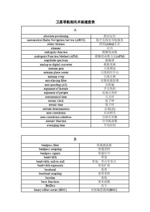
卫星导航相关术语速查表
Bureau International des Poids et Mesures (BIPM)
Butterworth filter
双相移键控(BPSK) 比特移位寄存器
BlockI,II,IIA,IIR,IIR-M,IIF(型)卫星 BOC(m,n)码 boxcar 滤波器
国际时间局
巴特沃思(Butterworth)滤波器
粗捕获(C/A)码 载噪比(C/N0) 载波相位测量 载波跟踪环
载波消除 铯原子钟 特征方程(式)
码片 码率 片式原子钟(CSAC) 园误差概率 钟噪声 闭环转移函数 码-载波发散 码钟 码分多址(CDMA) 码发生器 码相位测量 码转换 码消除 相干信号跟踪 冷启动 梳状函数 共视时间传递 复指数 结构干涉 辐射(方向)图可控天线 控制段 控制段误差 传统惯性参考系统 传统陆地参考系统
带宽,零点至零点 带宽扩展 基带 基带采样 基线 基本函数 北斗
双相偏置载频(BOC)
binary phase shift keying (BPSK) bit shift register
Block I, II, IIA, IIR, IIR-M, IIF satellites BOC(m,n) codes boxcar filter
- 1、下载文档前请自行甄别文档内容的完整性,平台不提供额外的编辑、内容补充、找答案等附加服务。
- 2、"仅部分预览"的文档,不可在线预览部分如存在完整性等问题,可反馈申请退款(可完整预览的文档不适用该条件!)。
- 3、如文档侵犯您的权益,请联系客服反馈,我们会尽快为您处理(人工客服工作时间:9:00-18:30)。
Abstract
The research presented in this paper is aimed at developing a positioning system that can support aircraft surface movement guidance (ASMG) [ 13 for commercial aircraft in all weather conditions while maintaining traffic flow equivalent to visual meteorological conditions (VMC). Runway incursion trends suggest that the safety margin during the surface operation is reducing. An advanced surface movement guidance system for all surface vehicles operating on airport property could significantly diminish this trend. The proposed system is designed to provide high accuracy position information to an aircraft from touchdown through rollout, turnoff and taxi to the gate area and vice-versa from pushback to takeoff position.
Inertial Navigation System The Inertial Navigation System (INS)is a Honeywell Laser Inertial Reference Unit that is certified for the McDonnell Douglas MDl 1 aircraft.
Laser Inertial Reference Unit MFG. P/N H G l l 5 0 BD02 Series #1 Date of Man Nov. 88 The INS output parameters (the navigation computations are implemented within the system) are serially transmitted on three high-speed ARINC 429 interfaces [4]. Input data is received on five separate input ports in ARINC low-speed format ~41. The specifications of the ARINC 429 outp 1 [4]. Only the information pertinent to the proposed INS/GPS integration is shown.
0-7803-6395-7/00/$10.00 02000 IEEE
2.E.5-1
14-element Dipole Antenna Array features an omnidirectional radiation pattern in azimuth and a directional pattern in elevation, with maximum gain between 5" and 35", measured upward from the horizon. The HZA also exhibits an omni-directional pattern in azimuth and a directional pattern in elevation, with the maximum gain between 35" and 90". The Dipole Antenna Array has a sharp roll-off radiation characteristic in elevation from +3" to -3" [3] to limit multipath signals reflecting off the surface of the earth. To decorrelate multipath, which is not rejected by the IMLA antenna pattern, three MLA antennas, spaced by 80 m, are situated at the LGF. These are connected to six independent NovAtel GPS receivers, which decode and process the GPS signals in space. After checking for common errors and verifying consistency, the differential corrections are calculated and broadcast to the airborne receiver via a Very-High Frequency Data Broadcast (VDB) system.
integration seems promising. The LAAS system provides sub-meter accuracy and therefore enhances an accurate INS bias and INS drift calibration as soon as the aircraft enters the coverage volume of the LAAS system. The INS provides the short-term stability needed to overcome issues associated with LAAS outages and the low measurement-sampling rate. The integration is achieved by means of a Complementary Kalman filter [2] that uses the INS as a reference system and estimates its error states with the aid of the LAAS. A prototype system was implemented in a research van. The setup consists of a Honeywell Ring Laser Gyro-based Inertial Reference Unit, certified for the MD11 aircraft, and a LAAS prototype system, developed by Ohio University. The collected data were processed using the Complementary Kalman filter and the system performance was evaluated. The results presented in this paper focus on the system performance in the presence of failure scenarios, such as LAAS outages due to excessive multipath and signal blockage.
Ground-based system
The LAAS Ground Facility, developed at Ohio University, employs Integrated Multipath-Limiting Antennas (IMLA) consisting of a Dipole Antenna Array and a High-Zenith Antenna (HZA) [3]. The
INTEGRATION OF LOCAL AREA AUGMENTATION SYSTEM AND INERTIAL NAVIGATION SYSTEM FOR AIRCRAFT SURFACE MOVEMENT GUIDANCE
Lukas M. Marti, Ohio University, Athens, OH
Introduction
Currently major airports support landings under low visibility or instrument meteorological conditions (IMC) providing the Instrument by Landing System (ILS). However, ILS does not provide guidance during surface operations, except for aircraft rollout. Painted lines, high intensity lights, and/or follow-me ground vehicles enable guidance to the terminal. This procedure can result in slow runway clearance and an increase in the separation distance between aircraft in the final approach queue in reduced visibility conditions. This affects the traffic flow at an airport and can lower safety. Furthermore, delays induce an economical burden for airlines and passengers. The projected increase in air traffic over the next decade justifies the development of an ASMG system, under the assumption that resources, such as new airports and runways, are not proportionally expanded. A combined Inertial Navigation System (INS) and Local Area Augmentation System (LAAS)