VMT盾构导向系统软件SLST计算DTA线路元素输入方法
VMT操作介绍
3、移站时数据的输入
(1)从控制导线上,测量出TCA全站仪和后视靶的 坐标,高程采用三角高程测量,用全站仪直接测出.测 量完成后,把所测量的数据输入控制室的电脑中。(在 操作系统的三级功能键里进行) (2)当数据输入完成后,全站仪大致瞄准后视点后, 开始定向.当定向完成之后,进行推进,当显示姿态与 移站前变化不大时,在进行方位检查,如果姿态变化大 或者方位检查超限时,进行数据输入检查或者移站测量 检查,或者对已知导线检查.
一、VMT系统的基本原理
1、现在的盾构机都装备有先进的自动导向系统, 我们盾构 机上的自动导向系统为德国VMT公司的SLS-T系 统,主要有以下四部分组成:(1)具有自动照准目标的全站 仪。主要用于测量(水平和垂直的)角度和距离、发射激 光束。(2)ELS(电子激光系统),亦称为标板或激光靶 板。这是一台智能型传感器,ELS接受全站仪发出的 激光束,测定水平方向和垂直方向的入射点。坡度和旋 转也由该系统内的倾斜仪测量,偏角由ELS上激光器 的入射角确认。ELS固定在盾构机的机身内,在安装 时其位置就确定了,它相对于盾构机轴线的关系和参数 就可以知道。(3)计算机及隧道掘进软件。SLS-T软 件是自动导向系统的核心,它从全站仪和ELS等通信 设备接受数据,盾构机的位置在该软件中计算,并以数字 和图形的形式显示在计算机的屏幕上,操作系统采用W indows2000,确保用户操作简便。(4)黄色箱子。 它主要给全站仪供电,保证计算机和全站仪之间的通信 和数据传输。
所有测得的数据由通信电缆传输至计算机通过软件组合起来用于计算盾构机轴线上前后两个参考点的精确的空间位置并与隧道设计轴线dta比较得出的偏差值显示在屏幕上这就是盾构机的姿态在推进时只要控制好姿态盾构机就能精确地沿着隧道设计轴线掘进保证隧道能顺利准确的贯通
“VMT”数据输入方法

“VMT”数据输入方法一、硬件:1Leica全站仪及每台2个配套棱镜1个棱镜头;2黄盒子,它是电脑与全站仪的一个联系界面(终端);3“ELS”靶;4电缆股。
二、软件:一个新的工程就要使用新的软件,否则电脑在掘进过程中就会出现一些问题,软件在使用之前要先在其他电脑上试用一下。
盾构机在掘进之前需要输入的东西:一、编辑“DTA”:“DTA”表示隧道的线型,一般有新编辑的和载入两种。
1.先输入线路的起始里程(必须比进洞里程小50m左右);2.输入起始点的X、Y坐标和隧道的中心标高;3.输入起始方位角,输入隧道的仰(俯)角(角度单位是gon,1gon=0.9度)。
例如:坡度为上坡5‰竖直单元分为Straight(直线)和Circular curve(圆曲线)。
,输入的仰角为99.6816888;4.编辑水平“DTA”界面(Horizontal DTA Elements)单元,水平单元分为直线、缓和曲线、圆曲线。
按F3-Insert DTA Element(插入DTA单元),点击F3出现提示框问:需要输入的单元是什么?①点击Straight(直线),出现:Length(直线长度)、Angularoffset(直线调节角,一般为0,当设计线路出现错误或线路需要改变时输入)、Offset(线间距,直线一般为0);②点击Clothoide(缓和曲线或回旋曲线),出现:Length(缓和曲线长度)、Angular offset(直线调节角,一般为0)、 Offset(设计线间距)、Curvature(曲线转向,left左或right右);注:offset(线间距)以输入单元(直线、缓和曲线、圆曲线的起始点为准,以7标为例,第一段为0,第二段为0.148);③点击Circular Curve(圆曲线);出现:Length(曲线长度)、Angular offset(曲线调节角,一般为0)、 Offset(设计线间距,0.148)、Radius(曲线半径),注:线路向右转offset与radius输入为正,向左为负;④点击Clothoide(缓和曲线或回旋曲线),此时Offset(设计线间距)输入0.148;⑤点击Straight(直线),如果到线路结束前还有曲线需重复前面步骤,如没有曲线了,此时的Length(缓和曲线长度)就要输入计算出的曲线终点至隧道终点的长度(同输入起始里程一样,最好再延长50m)。
隧道精灵操作说明

目录1 软件概述 (1)2 软件安装 (1)3 运行程序 (6)3.1启动程序 (6)3.2新建工程 (7)3.3 打开工程 (10)4 数据输入、计算及导出 (12)4.1 盾构初始姿态 (12)4.1.1 铰接设置 (12)4.1.2 盾构位置输入 (13)4.1.3 滚动角输入 (14)4.1.4 棱镜数据输入 (15)4.1.5 导入工程 (16)4.1.6 盾构坐标 (16)4.2 隧道中心线 (17)4.2.1 平曲线输入 (18)4.2.2 竖曲线输入 (23)4.2.3 长短链设置 (27)4.2.4 复核中线 (28)4.2.5 坐标表 (31)4.2.6 正反算 (33)4.2.7 主点坐标导出 (35)4.3 盾构姿态测量 (37)4.4 管片姿态 (42)4.5 洞门中心 (45)4.5.1 洞门中心点拟合 (45)4.5.2 出洞计算 (50)4.6 辅助工具 (54)4.6.1 空间圆拟合 (54)4.6.2 空间直线拟合 (57)4.6.3 空间直线平移 (60)4.6.4 空间直线延长 (62)5 问题索引及解决 (63)5.1 打开工程文件 (63)5.2 保存工程文件 (63)5.3 数据输入 (64)5.4 数据导入 (64)5.5 数据导出 (64)1 软件概述隧道精灵软件是由上海米度测量技术有限公司自主开发,应用于盾构施工过程的测量数据处理软件。
软件具有盾构初始姿态、盾构中心线、盾构姿态计算、管片偏差计算、预留洞门、空间圆和直线拟合计算等隧道测量工作中日常的数据处理功能,软件具有模型科学,操作界面简捷,数据处理快,计算精度高等特点,使得测量人员能够轻松掌握隧道测量技术,并且可以实时得到准确的测量结果,极大的提高了数据处理效率。
软件安装、运行以在Win7平台的操作为例。
2 软件安装2.1双击隧道精灵图标如图2-1所示,即运行安装程序。
图2-1安装软件图标2.2右键单击隧道精灵图标出现如图2-2所示,选择打开,即运行安装程序。
盾构机操作规程

盾构机操作规程1、启动前首先检查盾构机各系统是否运转正常,并确认油脂、泡沫剂是否需要更换,冷却水及液压油温度是否正常,轨道、管路延伸、同步注浆工作是否到位.2、依次启动冷却水泵、齿轮油泵、推进油泵、辅助油泵、螺旋输送机油泵、注浆泵、空压机、齿轮油泵、黄油泵、盾尾油脂泵等动力装置.3、启动皮带输送系统和刀盘驱动电机,根据扭矩情况适当调整各项参数.4、各系统参数调节正常后,点击盾构机推进按钮,当土仓压力达到设定压力时启动螺旋输送机进行排土,推进过程中根据地质情况向土仓内注入膨润土或泡沫剂,并适当调整后闸门的开度,.5、使VMT进入掘进状态,推进过程中根据盾构机姿态的变化,适当调整各组千斤顶的压力差,推进过程中密切关注刀盘的扭矩情况,根据刀盘扭矩情况对推进速度做适当的调整.6、更换渣土车时,主司机接到信号员的满载信号时,盾构机进入停机模式并关闭螺旋输送机和后闸门,皮带机继续运转,空渣土车就位后,根据信号指令依次开启各系统.7、当一环推进结束后,使盾构机进入拼装模式,按照与启动时相反的顺序关闭各系统,为拼装管片的需要使冷却、拼装系统处于工作状态8、测量盾尾间隙,利用VMT计算出拼装点位,进入管片拼装作业.1、管片拼装点位计算完成后,盾构机便进入拼装模式.2、管片拼装机只能由拼装手操作,其他人未经允许不得进行操作.3、管片拼装手在开动管片拼装机前必须看清楚管片拼装机周围的情况,油缸底部若有油脂、污水,要及时进行清理.4、根据拼装点位,依次缩回对应管片的千斤顶,一次最多缩回的数量不宜超过5组.5、管片在吊起前,拼装手必须检查拼装头是否上紧,看清该管片的型号及顺序,然后再用管片运输机把管片运到合适位置.6、管片被吊装起后,拼装手必须控制好旋转速度,把管片平稳的旋转到将要拼装的位置,然后进行拼装.7、拼装过程中,拼装手要站在有利位置看清管片的主要位置,看不到的位置要与其他拼装人员配合,拼装K块时,为防止止水条撕裂,可在止水条上涂抹润滑剂,每环管片的拼装错台保证在5mm以内.8、管片被推进油缸顶住后,如果要对管片进行微调必须把推进油缸收回后方可进行下一步的工作.9、每块管片定位完成后,对螺栓进行紧固,下一环推进快结束时进行二次紧固.10、在拼装过程中如遇到紧急情况必须及时向领班工程师或盾构机主司机汇报,进行紧急处理.1、同步注浆液到达盾构机台车位置后,先对浆液进行充分的搅拌,搅拌均匀后再开启渣浆泵,将浆液泵送到盾构机上的浆液罐内,泵送完成后用膨润土对浆液罐及泵送管路进行充分的清洗,防止浆液固结在管路内.2、在推进之前,首先检查设备及压浆管路是否正常,如有堵塞,要处理好后再进行推进和同步注浆.3、根据注浆指令,设定好各项注浆参数,同步注浆压力一般为地层土压力P加上,其压力应该大于外部水压,小于盾尾油脂腔的保压值,避免因压力过高造成击穿盾尾或浆液进入掌子面的情况.4、盾构推进10cm后便可开始注浆作业,根据推进速度的大小调整注浆的压力和注浆量,推进过程中根据每组注浆泵的冲程数和推进距离判断注浆是否饱满.5、注浆过程中,密切关注注浆系统的运行情况,详细记录注浆全过程的各项参数,注意注浆压力的变化,由此判断管路是否堵塞.6、注浆停止时,要用膨润土及时清洗管道,根据管路的长度计算所需的冲程数.7、盾构停机注浆时间间隔较长时,要彻底的清洗管路和注浆泵,注浆管路要在泄压后方可拆卸,清洗完毕后关闭盾尾处的闸阀,防止浆液逆流凝固后堵塞盾尾管路.电瓶车安全操作规程1.交班时,机车司机必须按交接班记录的有关内容,详细填写机车运行状态的记录.2.接班时,司机检查交接班记录,查看是否有遗留问题.3.机车运行前,查看机车周围有无影响机车运行的故障、电缆线等物件.4.开通电源后,观察空压机是否正常工作,压力表Ⅱ中黑针压力为时,机车方可运行.5.检查所有照明、喇叭是否正常.6.机车常规制动用电制动即可,机车运行时遇到紧急情况时实施空气制动,机车需长时间停车时实施手制动防止机车溜走.7.机车在行驶中,严禁司机将头或身体路出车外.8.机车在运行中,严禁司机上下车,司机不得携带他人乘车.9.机车起动时和正常行驶途中,严格按照信号开车,勤了望,思想集中,随时准备停车.10.不准在规定停车的范围以外任意停放车辆.搅拌站安全操作规程1.工作前,检查电源,查看仪表盘,如电压稳定可分步合上有关功能开关.2.操作台电源接通后,观察各磅缸对应的显示屏信号及各相关按钮的电源信号.3.打开空气压缩机读仪表数,在气压达到后才能开始操作,此时应检查气管和气阀的密封情况.4.打开出料螺旋输送机开关,空车试运转、试验出料闸板开关,反复观察有无异常情况.5.试开各泵缸下料蝶阀,观察是否正常,但前提必须是缸内物料为清零的空载状态.6.以上五点全部符合生产操作要求时,可发出相关生产指令信号,各磅缸开始磅料,投料入空机搅拌.注意:第一、二槽必须用人工操作,不能采用自动操作.7.搅拌机生产停顿2小时以上时,必须清洗生产设备.8.关机要在磅缸、主机、出料输送机等安全排空的状态下.9.关闭操作台电源,再依次关闭配电箱各种功能开关.10.做好设备日常保养工作,办好交接班手续.11.日常保养内容:(1)检查空压机油位,清洁外表.(2)检查粉煤灰输送机油位,尾部注黄油.(3)检查出料螺旋输机减速器油位,尾部注黄油.(4)膨润土输送机尾部注黄油.(5)砂料提升机主动轮、被动轮两端注黄油.(6)检查各活动部位螺丝坚固情况.(7)发现问题及时汇报,及时处理.1.开机顺序a.将给定电位器顺时针旋转到底.b.将“控制电源”开关打开“常规”或“计时”位置.c.合“电源合闸”按钮.d.顺时针调节给定电位器至所需电流.2.关机顺序a.将给定电位器反时针旋转到底.b.按动“电源分闸”按钮.c.将“控制电源”万能转换开关打至停止位置.d.当选择计时方式充电,“充电结束”信号灯指示以后,装置交流接触器没有断开,主电器仍处于带电状态,此时必须按照关机顺序操作关机.3.如遇到过载,黄灯亮,铃响时,应先将给定电位器反时针旋转到底,然后按动“复位按钮”,灯灭后再按照开机顺序重新开机.4.时间继电器最大设定时间为99小时99分钟,运行从0开始显示,至设定时间时自动停机,开机时间继电器不能为0,设定值在0时合不上闸.5.本装置特增设了防止蓄电池与充电机极性接错保护电器,当蓄电池与充电机的输出端极性接反时,该保护继电器动作,切断合闸回路,封锁脉冲,同时报警铃响,故障显示灯亮,提醒操作人员注意.1.司机必须经训练、考试,并持有操作证者方能独立操作,严禁无证操作.2.操作者必须熟悉起重机的用途、性能、操作方法和保养规则,并严格遵守安全操作规程.3.每班作业前应认真检查机械设备、电器部分和保护、保险装置是否完好、可靠.如果控制器、制动器、限位器、电铃、紧急开头等主要安全附件失灵,严格吊运.要按规定在各润滑点加油;露天吊车应打开其固定装置.4.吊重物时,司机必须在得到挂钩指挥信号后方能进行操作,吊车启动时要先鸣警铃.5.操作时,控制器手柄应从“0”门转到第一档,然后逐级减速,换向时,必须先转回“0”位.6.当接近卷扬限位器,大小车临近终端或与邻近吊车相遇时,速度要缓慢,不准用倒车代替制动,限位代替停车,紧急开关代替普通开关.7.司机必须听从信号员的指挥,对任何人发出的紧急停车信号都要立即停车.8.人员应在规定的安全直道、专用站台或扶梯上行走、上下大车轨道两侧除检修外不准行走,小车轨道严禁行走;不准从一台吊车跨越到另一台吊车上.盾构机主司机职责1、负责盾构机操作,控制好盾构机掘进姿态.2、负责编制盾构机操作规程及注意事项.3、负责盾构机掘进数据图表填写与上报.4、参与盾构机技术研究.5、参与盾构机故障处理、刀具更换方案的审定.6、认真学习盾构机操作的相关知识,熟悉盾构机的结构特点.7、所有盾构机主司机必须经过正规培训,经项目领导考核后方能独立操作盾构机.8、不得擅自离开操作室,禁止其他人员进入操作室内乱动操作按钮.9、盾构机各项参数出现异常时须及时上报,不得为进度而隐瞒不报.10、定期安排专人对设备进行维护保养.11、在盾构操作之前必须检查高压电缆的长度、VMT电缆的长度、循环水管的长度,冷却水的压力,空压机的运行状态,泡沫剂、油脂、密封脂、浆液的数量.设备标识牌做一个做一个每种做五个。
盾构导向系统的使用及保养
1.盾构导向系统的优点
• a. 可以显示盾构机的行进曲线(相对DTA); 实时显示盾构机的位置坐标和相对偏差;实 时显示盾构机的俯仰和旋转姿态,可实现远 程控制。 • b.测量复核的频率低。 • c.工作量相对小,施工过程中的导向测量需 要人员少。 • d.施工控制方便,精度高。 • e. 结合导向功能,实现在管片的拼装和管 片环测量方面的应用。
盾构导向系统的使用及保养
renhu 2012年09月28日
摘要:
目前,我公司主要用的为VMT的自动导向系统、PPS导向 系统和日本小松的导向系统,根据三个系统的对比和使用,在 准确性、安全性和实用性上比较还是VMT的导向系统比较稳 定。 本项目采用德国VMT公司生产的SLS-T自动导向系统进行控 制,该系统是目前世界上在地铁盾构法施工领域最为先进的隧 道掘进机自动导向系统。加强了施工过程中的管理水平和提高 工程自动化控制程度,减轻了人工测量的劳动强度,提高盾构 施工的速度,使用该系统可以满足盾构法施工测量的需要。 全面理解激光导向系统的原理,有助于工程技术人员在地铁 的盾构施工中及时发现问题,解决问题,保证隧道的正确掘进 和最后贯通 。
2.盾构导向系统的组成
g: 网卡 h:电缆卷盘 此外要实现该系统的功能,相关联的部件和软件 还有:盾构机掘进系统的PLC,要实现一些附加功 能的部件如自动测量盾尾间隙的部件、要实现管 片环收敛等量测的部件等,隧道掘进软件等。
2.盾构导向系统的组成
电缆线
整个系统的组 成情况及各个 部件之间的相 互关联如图所 示:
4.导向系统的日常故障及处理
⑺ 电脑显示不能测量到目标靶棱镜的距离, 故障可能为ELS靶的小棱镜被泥糊住,用软布 擦洗干净。 ⑻ 正常掘进中发现姿态跳动,故障可能为吊 篮被台车撞击或者前方的地质为硬岩。及时检 查一下激光站吊篮。
VMT SLS-RV 隧道盾构导向系统

SLS-RVTunnel Guidance System for pipe jackingSystem Features laser stationprismInclinometer Inclinometertunnelprismtunnelling machineprismELS targetThe SLS-RV system enables a laser mounted in the moving pipe to act as a sufficiently stable reference to enable long distance and curved pipejacks to be accomplished•Optimal control of machine position•Deviations from the designed tunnel axis held to a minimum•Recognition of machine drift right away •Start steering corrections in time•Provide a constant display of the position and orientation of the machine•Enormous time-saving against conventional methods•Simplify the surveying tasks on complex alignments (vertical and horizontal curves)•Large amount of information to enable optimal navigation of the TBM •Robust hardware for tunnelling•Easy handling and user-friendly software •Save of all drive related values in system database•Automatic measurement of pipeline •Visualization of machine positionon external PC (Option)•World wide modem connectionand remote control (Option)Display of machine TendenciesReference Line EditorDisplay of TBM PositionSLS-RVTunnel Guidance System for pipe jackingFor the guidance of extended distance and curved pipe jacked tunnels1`IntroductionDrivers of Tunnel Boring Machines (TBM) need continuous information about how the machine axis is positioned and oriented with respect to its Designed Tunnel Alignment (DTA).At the advance rates of several centimetres per minute that are common now, the driver must have immediate feedback about the consequences of his control actions in order to keep the machine as close as practical to the DTA.The SLS-RV Guidance System for Pipe Jacking gives users continuously updated information about the spatial position and orientation of the TBM. Thus,through properly controlled steering actions, the TBM can be kept within a narrow tolerance circle around the DTA.The main reference of the SLS-RV system is supplied by a visible laser beam projected from a Laser theodolite which is initially moun-ted in the shaft in an area that is relatively stable. This laser beam will typically project for a distance of between 100 – 200 m depending on the power of the laser, the atmospheric conditions in the tunnel and the amount of refraction that the laser beam is subjected to.The laser beam passes through the clear space in the machine and back-up equipment (laser window)to the target mounted on the forward part of the machine. The useable laser to target distance is also dependent on the size of thelaser window and the curvature of the tunnel.When the laser beam strikes the ELS Target the precise centre of the beam relative to the centre of the target is measured. The horizontal angle at which the laser beam strikes the ELS Target is also de-termined. Installed within the ELS Target is a dual axis inclinometer transducer to monitor the pitch and roll of the ELS Target. Attached to the front of the ELS Target is a retro-reflective prism. The distance be-tween the laser reference position and the ELS Target is measured by the EDM within the theodolite. Therefore from the knowledge of the absolute position of the laser reference, the absolute position and orientation of the ELS Target and hence the position and orientation of the TBM can be established.This information is combined with the desired alignment of the drive to give the machine operator a simple indication of where the machine is,relative to where it should be. The SLS – RV system not only provides a way of measuring the precise position of the TBM at any time –especially during the course of an advance. It presents these results to the operator in a clear, concise manner allowing him to take the necessary corrective measures.Apart from an enormous time saving, it also provides a uniform,smooth tunnel advance closely following the DTA.In pipe jacking, it is essential to avoid sudden changes in direction and in point loading the outer edges of the pipe, as damage in the area of the seal cannot be tolerated if the water tightness of the drive is to be maintained. Changes in direction cause more resistance to the movement of the machine and all the following pipes, requiring greater hydraulic forces to over-come this increased resistance In the case of pipe-jacking however, there is one fundamental difference in the supply of the guidance information to the machine operator. This is the po-sitioning of the laser reference in a stable position once the machine has advanced to a point where the laser beam can no longer activate the ELS Target from the start shaft.At this point the laser reference must be positioned within the moving pipe. As soon as the laser reference is no longer in a stable position, it is necessary to accom-modate this fact.The following assumptions are made and additional information is recorded.The basic assumption that is made in pipe jacking is “the pipe will follow the hole made by the machine”. This is not always valid and adjustments are sometimes necessary in the subsequent calc-ulations. However it is a good basis on which to commence this description.SLS-RVTunnel Guidance System for pipe jacking2`Operating PrinciplesThe position of the machine is recorded throughout the drive at frequent intervals. When it is necessary to install the laser in one of the moving pipes, the position of the centre of that pipe will be known from the records, i.e. the po-sition of the machine at the same chainage. However the orientation of the pipe will almost certainly be different from that of the machine.If the laser reference is not in the precise centre of the pipe, any roll on that pipe will cause a positional change for the laser reference. The roll of the pipe is therefore measur-ed by an inclinometer and the roll-corrected value for the laser refer-ence position can be calculated.In order to maintain the laser orientation at a constant elevation and thus eliminate the effect of any pitching of the pipe from the calculations, the laser theodolite is mounted on a self-levelling plat-form. This overcomes any move-ment of the pipe due to both pitch-ing and rolling, and maintains the theodolite within its compensator setting range.The azimuth of the laser refer-ence is determined with respect to a backsight target. When this back-sight target is mounted in a stable position (i.e. the start shaft) the determination of the azimuth is straightforward. However, as soon a it becomes necessary to mount the backsight target into a moving pipe it is also necessary to use the re-corded values of the machine position at a given chainage to determine the position of the pipe containing the backsight target at the same chainage. It is also neces-sary to monitor the roll of the pipe with an inclinometer to give a roll-corrected position for the backsight target.Using these values to precisely determine the instantaneous po-sition and orientation of the laser reference, it is possible once again to show the operator the position of the tunnelling machine in relation to the desired alignment.In practice however, the accuracy achieved by following these basic assumptions together with external effects such as irregularities in pipe manufacture, extreme overcutting or a tight radius curved alignment, is not sufficient to achieve the required tolerances specified for the drive. It is therefore necessary to carry out periodic control surveys to replace the recorded machine position data with measured survey data. These control surveys should be carried out at intervals of not greater than every 100m.It has also been found that the dynamic behaviour of the pipes due to variable ground conditions and the varying hydraulic forces applied during the mining operation show significant differences to the measurements taken during static control surveys. It has therefore proved necessary to update the recorded data on the course follow-ed by the pipes between control surveys.The advent of motorised laser theodolites has enabled a more frequent, automatic measurement cycle to be undertaken between control surveys.This measurement cycle not only gives updates on the position and orientation of the laser but also of the position of a reference pipe a short distance ahead of the laser.The position of this reference pipe is recorded and stored as the reference line which the system uses as its working record of the pipe line’s position. This reference line can be modified (smoothed) by the user to take into account the anomaliesA VMT concept Laser Theodolitethat occur during this precise measurement cycle to produce a more realistic reference for guiding the drive. The complete system is installed in the front region of the pipeline, where refraction typically does not cause significant problems.System ComponentsAll components have been extensively tested on running TBM’s and have been thoroughly tried and tested in the harsh environment of numerous pipe jacking projects.They are briefly described below Active ELS (electronic laser system)The Target receives the laser beam. It determines the point of incidence in a horizontal and vertical direction. In addition, the roll and pitch are measured by integrated inclinometers. The yaw angle is ascertained from the angle of incidence of the laser on the ELS.The ELS is fixed to the TBM body, its position having been determined when it was installed. A prism for electronic length measurement is mounted directly below the ELS.Controller UnitAt laser station supplies power for theodolite, AD-12, inclinometer,backsight target inclinometer and length measurement system. It multiplexes data from inclinome-ters, length measurement system and laser theodolite and provides data communication with the control PC.Laser TheodoliteThe VMT concept Motorized servo Laser Theodolite, (Leica TCA1103 /ATR / GUS74) complete with PC control and automatic target re-cognition (ATR2), allowing precise targeting of the prism, is a precisionSLS-RV Tunnel Guidance System for pipe jacking 3The Guidance Sytemis operated by Touchscreen geodetic measuring instrument formeasuring (horizontal and vertical)angles and distances and projectinga visible laser reference beam.Automatic tribrach AD-12Automatic tribrach for self-levelling of the laser station within a±10 gon range. Levelling is carriedout continually with an accuracy of± 1 mgon.Inclinometer on laser stationInclinometer fixed on bracket oftotal station, determines the currentroll angle of the station andtransmits this data to the control PCvia the Controller Unit.SLS-RV Industrial PCComputer station at operatorposition where all the datadetermined is automaticallycombined and evaluated. Theinformation is displayed on themonitor in numerical and graphicalform. The TBM position can thus beseen at a glance. Used forevaluating and saving all geo-metrically relevant measured data.Backsight target.Standard, round retro-reflectiveprism as rear backsight target. Usedin automatic mode as direction ref-erence. Recognised and measuredby the ATR2 target recognition unit.Inclinometer at backsight targetFixed inclinometer on thebracket of the backsight target,determines the current roll of thestation and transmits the data tothe Controller Unit.Left and Right reference-pointprisms in front of the laser stationTwo Standard round retro-reflective prisms known asreference targets are located in areference pipe approx. 12 m in frontof the laser station. Their purpose isto allow measurement of the actualposition of the advancing tunnel asdirectly in front of the laser stationas possible, so that any variancebetween the pipes measuredposition and that of the theoreticalposition of the TBM at the samestation can be determined.Length measurement systemWheel mechanism mounted instart shaft on pipeline. When thepipeline is inserted by means of themain jack system, the impulsesgenerated by the measurementwheel are transmitted forcomputation.Set of Interconnecting CablesAll cables to connect theindividual components of thesystem.TBM Position Software moduleIt forms the heart of SLS-RVsystem. It receives data from all theabove-mentioned components. TheTBM position is calculated in theTunnel Advance Software. Display isgraphical and numerical. Ease ofoperation is ensured by theWindows user interface.Reference Line editorA graphical module allows thereference point axis generated to bechecked and edited when necessary.It allows smoothing, removing oferroneous values, and allows a newreference point axis to be generatedfollowing a control survey.Reference PipeRemote OperationModem(option)DistributionBox 1SPS (TBM PLC)TBM Laser StationControl CabinIndustrial PCLMS** LengthMeasurementSystemBacksight TargetBacksight TargetReference TargetReference Target InclinometerInclinometerStart ShaftController UnitTheodoliteHardware Configuration`。
VMT盾构导向系统软件SLST计算DTA线路元素输入方法
VMT(SLS-T)软件计算盾构线路DTA
软件准备:VMT盾构导向软件。
Ps:该软件的字体包必须是大写字母开头的,如果没有汉化包(CHINESE.DLL),英文的也能用。
操作点:
1、水平角单位“gon”:90度=100gon。
2、水平角是与正东方的夹角,顺时针为正。
3、弯曲选项:“向左”应为实际是向右。
4、半径正负:左转为正,右转为负。
5、偏差:左偏为正,右偏为负。
切偏差为该元素起点处的偏差。
6、平曲线角偏差,只要输入第一段直线的角偏差就好,以后的不用再
输。
7、竖曲线角偏差:第一段直线角偏差为坡角度(gon)上坡为正。
以后
的直线,皆为与前一段直线的相对方向夹角,顺时针为正。
8、竖曲线半径:凹曲线为正,凸曲线为负。
9、竖曲线只用第一段直线取角偏差(或初始点角偏差),之后的夹直线
段,不用输入角偏差。
10、竖曲线圆曲线的长度约为2倍切线长,半径越大越接近。
11、平纵曲线长度应一样。
有错误的地方,希望各位前辈指正批评(729694040),以免误导他人。
还有其他功能未完全理解,希望大家相互分享交流。
此软件虽然难用,但是毕竟是专业的盾构软件,计算数据应有一定的权威性。
计算结果最好上图CAD且用其它专业计算软件对比方可确认无误。
作者蒲40 2016-9-13于广东华隧。
隧道掘进机(TBM)VMT激光导向系统控制
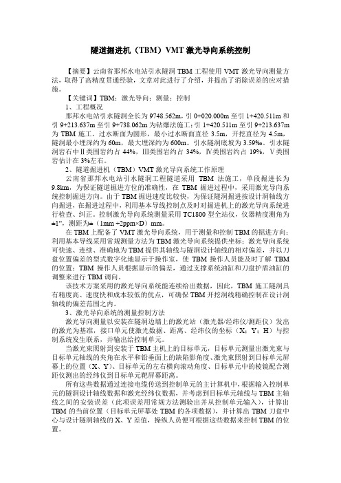
隧道掘进机(TBM)VMT激光导向系统控制【摘要】云南省那邦水电站引水隧洞TBM工程使用VMT激光导向测量方法,取得了高精度贯通经验,文章对此进行了介绍,并提出了消除误差的应对措施。
【关键词】TBM;激光导向;测量;控制1、工程概况那邦水电站引水隧洞全长为9748.562m,引0+020.000m至引1+420.511m和引9+213.637m至引9+738.062m为钻爆法施工;引1+420.511m至引9+213.637m 为TBM施工。
过水断面为圆形,最小过水断面直径3.5m,开挖直径为4.5m,隧洞最小埋深约为60m,最大埋深约为600m。
引水隧洞底坡为3.59‰。
引水隧洞岩石中Ⅱ类围岩约占44%,Ⅲ类围岩约占34%,Ⅳ类围岩约占19%,Ⅴ类围岩估计在3%左右。
2、隧道掘进机(TBM)VMT激光导向系统工作原理云南省那邦水电站引水隧洞工程隧道采用TBM法施工,单段掘进长为9.8km,为保证隧道掘进方位的准确性,在TBM掘进过程中,采用激光导向系统控制掘进方向。
由于TBM掘进速度比较快,为保证隧洞掘进按设计洞轴线方向掘进,在掘进过程中,利用基本导线控制点及时对掘进机上的激光导向系统进行检查、纠正。
控制激光导向系统测量采用TC1800型全站仪,仪器精度测角为±1”,测距为±(1mm +2ppm×D)mm。
在TBM上配备了VMT激光导向系统,用于测量和控制TBM的掘进方向;利用基本导线采用常规测量方法为TBM激光导向系统提供坐标;激光导向系统可快速、连续、准确地为TBM提供其轴线与隧洞设计轴线的相对偏差,并以刀盘位置偏差的型式数字化地显示于操作室,使TBM操作人员能及时了解TBM 的位置;TBM操作人员根据显示的偏差,通过支撑系统油缸和刀盘护盾油缸的调整来进行TBM调向。
该技术方案采用的激光导向系统能连续给出数据,因此,TBM施工隧洞具有精度高、速度快和成本较低的优点,可确保TBM开挖洞线精确控制在设计洞轴线的偏差范围之内。
- 1、下载文档前请自行甄别文档内容的完整性,平台不提供额外的编辑、内容补充、找答案等附加服务。
- 2、"仅部分预览"的文档,不可在线预览部分如存在完整性等问题,可反馈申请退款(可完整预览的文档不适用该条件!)。
- 3、如文档侵犯您的权益,请联系客服反馈,我们会尽快为您处理(人工客服工作时间:9:00-18:30)。
VMT(SLS-T)软件计算盾构线路DTA
软件准备:VMT盾构导向软件。
Ps:该软件的字体包必须是大写字母开头的,如果没有汉化包(CHINESE.DLL),英文的也能用。
操作点:
1、水平角单位“gon”:90度=100gon。
2、水平角是与正东方的夹角,顺时针为正。
3、弯曲选项:“向左”应为实际是向右。
4、半径正负:左转为正,右转为负。
5、偏差:左偏为正,右偏为负。
切偏差为该元素起点处的偏差。
6、平曲线角偏差,只要输入第一段直线的角偏差就好,以后的不用再
输。
7、竖曲线角偏差:第一段直线角偏差为坡角度(gon)上坡为正。
以后
的直线,皆为与前一段直线的相对方向夹角,顺时针为正。
8、竖曲线半径:凹曲线为正,凸曲线为负。
9、竖曲线只用第一段直线取角偏差(或初始点角偏差),之后的夹直线
段,不用输入角偏差。
10、竖曲线圆曲线的长度约为2倍切线长,半径越大越接近。
11、平纵曲线长度应一样。
有错误的地方,希望各位前辈指正批评(729694040),以免误导他人。
还有其他功能未完全理解,希望大家相互分享交流。
此软件虽然难用,但是毕竟是专业的盾构软件,计算数据应有一定的权威性。
计算结果最好上图CAD且用其它专业计算软件对比方可确认无误。
作者蒲40 2016-9-13于广东华隧。