英语考试作文-9分雅思图表写作范文全集之地图篇 小岛变迁
岛屿变迁 雅思作文

岛屿变迁雅思作文英文回答:The ceaseless dynamism of nature is exemplified in the phenomenon of island metamorphosis, a process where islands emerge, vanish, or undergo significant transformations over time. This intricate interplay of geological and environmental forces has profound implications for the ecosystems and human communities that inhabit these dynamic landscapes.Island formation can occur through volcanic eruptions, where magma rises from the Earth's crust and accumulates above the waterline, forming new landmasses. Tectonic plate movements can also contribute to island formation, as plates collide or diverge, causing landmasses to shift and rise or subside. Sedimentation processes, such as the accumulation of sand, silt, and gravel, can gradually form islands over extended periods.The disappearance of islands, on the other hand, can result from various factors. Erosion by wind and water can gradually wear away islands, reducing their size and eventually submerging them beneath the ocean's surface. Volcanic eruptions can also lead to island destruction, as lava flows, ashfall, and pyroclastic surges can decimate landforms. In addition, sea level rise, driven by climate change, poses a significant threat to low-lying islands, increasing the risk of inundation and eventual submergence.Island transformation involves significant changes in the size, shape, or elevation of existing landmasses. These changes can be gradual, occurring over centuries or millennia, or they can be abrupt, resulting from catastrophic events such as earthquakes or tsunamis. Island transformation can have profound ecological consequences, altering habitats for flora and fauna, disrupting food chains, and impacting the livelihoods of human communities.The study of island metamorphosis is crucial for understanding the complex interactions between geological processes, environmental change, and the resilience ofecosystems. By investigating past and present island dynamics, scientists can gain insights into the long-term evolution of Earth's surface and the potential impacts of future environmental challenges, such as climate change and sea level rise.中文回答:岛屿变迁。
剑桥雅思小作文写作提示9-修改
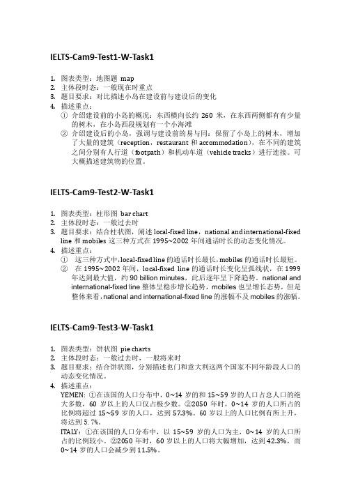
IELTS-Cam9-Test1-W-Task11.图表类型:地图题map2.主体段时态:一般现在时重点3.题目要求:对比描述小岛在建设前与建设后的变化4.描述重点:①介绍建设前的小岛的概况:东西横向长约260米,在东西两侧都有有少量的树木,在小岛西段规划有一个小海滩②介绍建设后的小岛,强调与建设前的易与同:保留了小岛上的树木,增加了大量的建筑(reception,restaurant和accommodation),在不同的建筑之间分别有人行道(footpath)和机动车道(vehicle tracks)进行连接。
可大概描述建筑物的位置。
IELTS-Cam9-Test2-W-Task11.图表类型:柱形图bar chart2.主体段时态:一般过去时3.题目要求:结合柱状图,阐述local-fixed line,national and international-fixedline和mobiles这三种方式在1995~2002年间通话时长的动态变化情况。
4.描述重点:①这三种方式中,local-fixed line的通话时长最长,mobiles的通话时长最短。
②在1995~2002年间,local-fixed line的通话时长变化呈弧线状,在1999年达到最大值,约90 billion minutes,此后逐年呈下降趋势。
national and international-fixed line整体呈稳步增长趋势,mobiles也呈增长态势,但是整体来看,national and international-fixed line的涨幅不及mobiles的涨幅。
IELTS-Cam9-Test3-W-Task11.图表类型:饼状图pie charts2.主体段时态:一般过去时,一般将来时3.题目要求:结合饼状图,分别描述也门和意大利这两个国家不同年龄段人口的动态变化情况。
4.描述重点:YEMEN: ①在该国的人口分布中,0~14岁的和15~59岁的人口占总人口的绝大多数,60岁以上的人口仅占极少数。
英语考试作文-9分雅思图表写作范文全集之地图篇 学校变迁
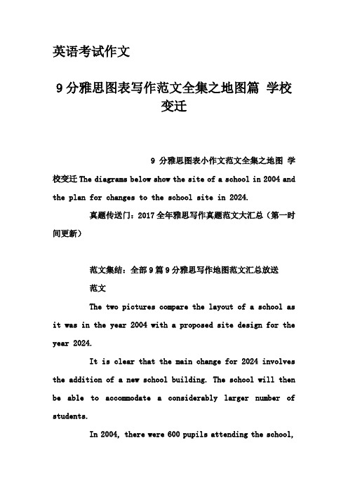
英语考试作文9分雅思图表写作范文全集之地图篇学校变迁9分雅思图表小作文范文全集之地图学校变迁The diagrams below show the site of a school in 2004 and the plan for changes to the school site in 2024.真题传送门:2017全年雅思写作真题范文大汇总(第一时间更新)范文集结:全部9篇9分雅思写作地图范文汇总放送范文The two pictures compare the layout of a school as it was in the year 2004 with a proposed site design for the year 2024.It is clear that the main change for 2024 involves the addition of a new school building. The school will then be able to accommodate a considerably larger number of students.In 2004, there were 600 pupils attending the school,and the two school buildings were separated by a path running from the main entrance to the sports field. By 2024, it is expected that there will be 1000 pupils, and a third building will have been constructed. Furthermore, the plan is to join the two original buildings together, creating a shorter path that links the buildings only.As the third building and a second car park will be built on the site of the original sports field, a new, smaller sports field will need to be laid. A new road will also be built from the main entrance to the second car park. Finally, no changes will be made to the main entrance and original car park.(183 words, band 9)。
英语考试作文-9分雅思图表写作范文全集之地图篇两地变迁

英语考试作文-9分雅思图表写作范文全集之地图篇两地变迁英语考试作文9分雅思图表写作范文全集之地图篇两地变迁9分雅思图表小作文范文全集之地图两地变迁The maps illustrate how Meadowside village and Fonton, which is a neighbouring town, have developed over three different time periods (1962, 1985 and the present).范文集结:全部9篇9分雅思写作地图范文汇总放送范文:Overall, Meadowside village increased in size and has become Meadowside Suburb as it merged together with Fonton. Furthermore, there have been significant changes in infrastructure, housing and facilities over the period given.In 1962, both Meadowside and Fonton were completely separate with no roads or rail connecting them. While Fonton had a railway line running through it to the north, Meadowside, located to the west of Fonton, only had a small road from the west.By 1985, there was a considerable growth in the size of Meadowside village and Fonton. The small road in Meadowside village had been converted into a main road and was also extended to the east to connect with Fonton. Meadowside, moreover, had also developed a housing estate in the west, a leisure complex and a supermarket in the south.Currently, both Meadowside, which is now a suburb, and Fonton are joined. The railway line, which runs through Fonton, has been extended to the west where a train station has been built. To the north of the station, a hotel has been constructedand opposite the station, to the south, there is now a business park.。
雅思小作文范文-地图
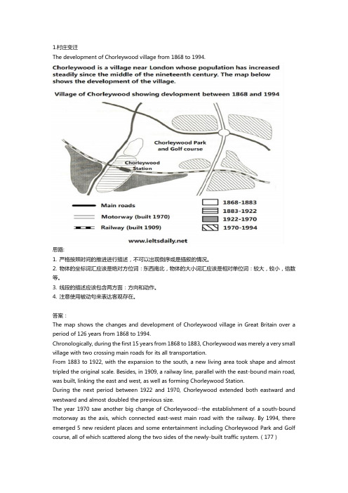
The development of Chorleywood village from 1868 to 1994.思路:1. 严格按照时间的推进进行描述,不可以出现倒序或是插叙的情况。
2. 物体的坐标词汇应该是绝对方位词:东西南北,物体的大小词汇应该是相对单位词:较大,较小,倍数等。
3. 线段的描述应该包含两方面:方向和动作。
4. 注意使用被动句来表达客观存在。
答案:The map shows the changes and development of Chorleywood village in Great Britain over a period of 126 years from 1868 to 1994.Chronologically, during the first 15 years from 1868 to 1883, Chorleywood was merely a very small village with two crossing main roads for its all transportation.From 1883 to 1922, with the expansion to the south, a new living area took shape and almost tripled the original scale. Besides, in 1909, a railway line, parallel with the east-bound main road, was built, linking the east and west, as well as forming Chorleywood Station.During the next period between 1922 and 1970, Chorleywood extended both eastward and westward and almost doubled the previous size.The year 1970 saw another big change of Chorleywood--the establishment of a south-bound motorway as the axis, which connected east-west main road with the railway. By 1994, there emerged 5 new resident places and some entertainment including Chorleywood Park and Golf course, all of which scattered along the two sides of the newly-built traffic system.(177)Two possible sites for a shopping mall in the city of Brandfield.思路:1. 注意描述的过程:可为由内至外,由外至内,由左至右,由上至下等。
地理变迁图写英语作文
地理变迁图写英语作文Maps, as silent witnesses of time, narrate the intricate tale of our planet's ever-changing geography. They are not merely tools for navigation but living documents that encapsulate the dynamic nature of Earth's surface, coasts, mountains, rivers, and even civilizations. A geographical evolution map, therefore, stands as a testament to the relentless march of geological processes and human interventions that have shaped our world.The earliest maps, rudimentary and often mythical, reflected humanity's nascent understanding of the world. They were filled with imagined lands, mythical creatures, and distorted proportions, yet they marked a significant milestone in cognitive development. As cartography advanced, maps began to mirror reality more accurately, capturing the essence of geographical features with greater precision.One of the most striking aspects of geographical evolution maps is the depiction of how coastlines have altered over millennia. The rise and fall of sea levels, tectonic plate movements, and the relentless work of erosion have reconfigured shorelines, turning once-thriving ports into arid plains or submerged landscapes into vibrant marine ecosystems. Studying these changes offers insights into the Earth's climatic history and futurepredictions.Mountain ranges, too, have their tales etched onto these maps. The formation of the Himalayas, for instance, not only redefined the topography of Asia but also influenced global climate patterns. Such maps illustrate how these majestic structures emerged from the collision of tectonic plates, pushing the Earth's crust upwards and creating some of the most awe-inspiring landscapes on the planet.Rivers, the lifelines of civilizations, also undergo transformations captured by these maps. The shifting courses of rivers like the Nile or the Yellow River reveal how natural forces and human activities have redirected water flows, impacting agriculture, urban settlements, and ecosystems.Moreover, geographical evolution maps underscore the impact of human activities. Urban sprawl, deforestation, and the creation of artificial lakes and reservoirs are but a few examples of how humanity has left its mark on the planet's surface. These changes, both beneficial and detrimental, serve as a reminder of our responsibility towards sustainable development.In conclusion, geographical evolution maps are more than just collections of lines and symbols; they are visual narratives of our planet's past, present, and future. They invite us to ponder over the intricate dance between nature's forces and human ingenuity, inspiring us to cherish andpreserve the fragile beauty of our ever-evolving Earth.。
雅思小作文 地图
雅思小作文地图The map below shows the changes that have taken placein the town of Newtown since 2005.The map provides an overview of the development of Newtown from 2005 to the present day. It is clear thatthere have been significant changes in the town over this period, with new buildings and infrastructure being constructed.In 2005, Newtown was a relatively small town with a population of around 10,000 people. The town was centered around a main road, which ran from the north to the southof the town. There were a few residential areas to the east and west of the main road, as well as a small industrial area to the south of the town.By 2010, the town had undergone significant development.A new residential area had been built to the east of the main road, and a new shopping center had been constructedto the west. In addition, a new road had been built to the south of the town, connecting Newtown to the nearby city. The population of the town had also increased to around15,000 people.The most recent map, from 2020, shows that Newtown has continued to grow and develop. The residential area to the east of the main road has expanded, with new housing developments and a new school being built. The shopping center to the west has also been expanded, and there are now plans for a new hospital to be constructed in this area. The industrial area to the south has also grown, with new factories and warehouses being built.Overall, the maps show that Newtown has undergone significant changes over the past 15 years. The town has grown in size, with new residential, commercial, and industrial areas being developed. It is clear that Newtownis a town on the rise, and it will be interesting to see how it continues to develop in the future.This is a high-quality imitation of an IELTS map essay,with a detailed description of the changes in Newtown over the years. It meets the requirement of being over 1200words and provides a clear and coherent analysis of the map. Well done!。
雅思大作文地图变迁
雅思大作文地图变迁英文回答:In the ever-changing tapestry of our world, cities undergo constant transformation, their skylines and urban fabric shaped by the interplay of human activities and technological advancements. The study of urban geography provides a fascinating lens through which we can examinethe dynamic nature of cities and the factors that influence their evolution.One of the most striking aspects of urban geography is the way in which cities expand and grow. As populations increase and economies thrive, cities often expand outwards, annexing surrounding areas and incorporating them intotheir urban fabric. This process of urban expansion can be driven by a variety of factors, including economic growth, technological advancements, and government policies.In the early stages of urban development, cities weretypically compact and densely populated, with narrowstreets and tall buildings. However, as cities grew and expanded, they began to spread out, with the development of suburbs and exurbs. This process of suburbanization was fueled by the advent of the automobile and the rise of the middle class.The expansion of cities has a profound impact on their social, economic, and environmental dynamics. As cities grow, they become more diverse, with people from different backgrounds and cultures coming together to live and work. This diversity can lead to both challenges and opportunities, as cities grapple with issues such as social inequality, housing affordability, and environmental sustainability.In addition to expansion, cities also undergo significant internal changes. As new technologies emerge and economic conditions shift, the character of different neighborhoods can change dramatically. This process of urban renewal can involve the redevelopment of old buildings, the construction of new infrastructure, and theinflux of new residents.The study of urban geography helps us to understand the complex processes that shape cities and the challenges that they face. By examining the historical development of cities, we can gain insights into the factors that have led to their success or decline. We can also use urban geography to inform policy decisions and to create more sustainable and livable cities for the future.中文回答:城市地理学是一门令人着迷的学科,它让我们能够审视城市的动态本质以及影响它们演变的因素。
雅思小作文地图题的写法课件
地图题的写法 ? 1 地理变迁类型 ? 2 选址类型
1
地理变迁题
2
注意要点:
? 1 时态问题 ? 一般过去时 一般将来时(表预测)现在完成时 (5月15日) ? This place was used as a reading room. ? The reading room has been removed and replaced
? It is likely that ...=it is expected / estimated that …
4
2 语态问题
? 被动语态是最好的选择。 ? The golf course has been built in the place where
there used to a forest. ? A new theater was established in Town of Grandson
inห้องสมุดไป่ตู้2000.
5
3 顺序问题
? 时间和空间顺序 ? 时间变化中的每一个细节 ? 空间顺序的表达方式 ? 1 A位于B(城镇)的中心 ? A is located /sited in the center / middle
area of B. ? 2 A位于B(城镇)的郊外 ? A is located /sited outside of B.
6
? 3 A 位于B (城镇)的东方 /西方/南方/北方 ? A is/ lies/ is located/ is sited to/in the
east/west/south/north part of B ? 4 A位于B(城镇)西南部的 10公里处 ? A is/ lies/ is located/ is sited 10 km to the
雅思小作文 地图题 村庄变迁
雅思小作文地图题村庄变迁In recent years, the transformation of rural villages has become a topic of great interest and concern. The rapid urbanization and modernization have led to significant changes in the landscape and lifestyle of these villages. This essay aims to discuss the factors contributing to the transformation of rural villages, the impact of these changes on the community, and potential solutions to address the challenges faced by these villages.One of the primary factors contributing to the transformation of ruralvillages is urbanization. As cities continue to expand, there is a growing demand for land and resources, leading to the encroachment of urban areas into rural villages. This has resulted in the displacement of local residents and the destruction of traditional agricultural practices. Additionally, the allure of better job opportunities and amenities in urban areas has led to a mass exodus of young people from rural villages, further contributing to the decline of these communities.Furthermore, the advancement of technology and infrastructure has also played a significant role in the transformation of rural villages. The introduction of modern amenities such as electricity, internet access, and transportation has brought about both positive and negative changes. While these advancements have improved the quality of life for some villagers, they have also led to the erosion of traditional values and practices. Moreover, the construction of new roads and buildings has altered the natural landscape of these villages, leading to environmental degradation and loss of biodiversity.The impact of these changes on the community has been profound. The social fabric of rural villages has been disrupted, leading to a sense of disconnection and loss of community spirit. The traditional way of life, which was once centered around agriculture and close-knit relationships, has been replaced by a more individualistic and consumerist mindset. This has resulted in a decline in thesense of belonging and identity among the villagers, leading to feelings of alienation and nostalgia for the past.In addition, the economic implications of the transformation of rural villages cannot be overlooked. The decline of agriculture and traditional industries has led to high levels of unemployment and poverty in these communities. Many villagers, especially the elderly, are struggling to make ends meet as they are unable to adapt to the changing economic landscape. This has led to a widening wealth gap and a sense of hopelessness among the villagers.Despite these challenges, there are potential solutions to address the issues faced by rural villages. One approach is to promote sustainable development and eco-tourism in these areas, which can help preserve the natural landscape and traditional way of life while providing economic opportunities for the villagers. Additionally, there is a need for investment in education and skills training to empower the younger generation and equip them with the tools to thrive in the modern world while preserving their cultural heritage.In conclusion, the transformation of rural villages is a complex issue withfar-reaching implications. While the changes brought about by urbanization and modernization have had a profound impact on these communities, there are opportunities to address the challenges and preserve the unique identity of rural villages. By embracing sustainable development and empowering the local community, it is possible to create a more inclusive and prosperous future for rural villages.。
- 1、下载文档前请自行甄别文档内容的完整性,平台不提供额外的编辑、内容补充、找答案等附加服务。
- 2、"仅部分预览"的文档,不可在线预览部分如存在完整性等问题,可反馈申请退款(可完整预览的文档不适用该条件!)。
- 3、如文档侵犯您的权益,请联系客服反馈,我们会尽快为您处理(人工客服工作时间:9:00-18:30)。
英语考试作文
9分雅思图表写作范文全集之地图篇小岛
变迁
9分雅思图表小作文范文全集之地图小岛变迁The two maps below show an island before and after the construction of some tourist facilities.Summarise the information by selecting and reporting the main features, and make comparisons where relevant.Write at least 150 Words.
范文集结:全部9篇9分雅思写作地图范文汇总放送
参考范文
The two maps demonstrate the changes made to an island after it was turned into a tourist resort.
The holiday resort which occupied about three quarter of the island consists of a reception building, a restaurant, and numerous chalets; all located within a walking distance. In addition, the reception area is also connected directly to a newly built pier which made it more accessible by visitors. For the convenience of the guests, a vehicle track that
connects the pier, the reception and the restaurant was also constructed.
To further promote the island as a holiday attraction, various spots of the island have been upgraded for recreational activities. For example, swimming is now available at the beach near the west end of the island and sailing can be done near the pier of the resort.
Overall, the transformation of the island into a vacation spot has brought much improvements to the island without any deforestation. As a matter of fact, there are now more trees in the island than before.
Total Words: 172
Task Achievement: 8
Coherence & Cohesion: 8
Lexical resources: 8
Grammar: 8
Overall Score: Band 8。