Part Two The Republic of Ireland
爱尔兰英文介绍RepublicofIreland

爱尔兰英⽂导游词爱尔兰英⽂介绍Republic of Ireland⽤英语介绍爱尔兰As far as tourist appeal goes, the small island of Ireland punches far above its own weight. The country is so packed with delights that visitors are often reduced to describing its charms in hyperbolic clichés: it is the greenest country, full of the friendliest people, all of whom would be geniuses if they weren't distracted by the lure of the pub.Ireland is indeed a green country - so much rainfall must have its benefits - and the people are justifiably renowned for their friendliness. As for the geniuses, well, the Irish will proudly point to their four Nobel Laureates for Literature and declare that the success rate is unmatched in any other country of its size, all the while ensuring that the sacred 'round' system (where everyone buys a drink for everyone else in turn) is strictly adhered to.Yet Ireland's charms run far deeper than the legendary craic of the pub or the accomplishments of a bunch of (mostly) dead writers. It has a remarkable history that is woven into virtually everything, from the prehistoric stone monuments of the Boyne Valley to the monuments honouring its fallen patriots, men and women who dared challenge the imperious might of its longtime occupier and contemporary friend, Britain.It has a vibrant and dynamic capital, Dublin, which has spearheaded a stunning period of economic growth that has seen the country transformed from rural backwater to the envy of Europe. As a result, the Irish have grown in worldliness that continues to propel them to greater heights of achievement. Even the thorniest issue of all - Northern Ireland - has seen a kind of resolution and Ireland looks to the future with untrammelled confidence.位于欧洲西部的爱尔兰岛南部。
爱尔兰(Ireland)
爱尔兰(Ireland )在爱尔兰出行, 是一种轻松愉悦的体验。
无论是穿梭在精致而小巧的现代化城镇,还是驰骋在芳草萋萋牛羊成群的田野乡间,总有看不尽的迷人风景和道不尽的淳朴人情。
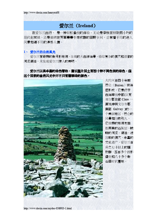
1、爱尔兰的自然風光爱尔兰有奇特的新月形地貌、壮观的大西洋海景、错综复杂的洞穴和清澈的河流湖泊,来发现爱尔兰惊人的美吧。
爱尔兰以其丰富的绿色著称,据说整片国土有四十种不同色调的绿色,但这个国家的自然风光中并不只有翡翠绿的颜色。
大约三百四十年前巴仑(Burren )在海底形成,它是位于西海岸线中部(从克莱尔郡北部 Clare 一直延伸到戈尔韦郡南部 Galway )的一个美丽地区。
巴仑的风景相当吸引人,它独特的地貌包括数英里的石灰层、蜿蜒的河流、湖泊、迷宫般的洞穴、丰富的文化遗产、爱尔兰百分之七十以上的植物群、五百多个圆形堡垒和八十多个新石器时代墓地。
也许巨人堤奇特的新月形地形其实是由于火山爆发和冷却的岩浆而形成,但爱尔兰的传说则给你讲述一个完全不同的神话故事。
巨人堤(联合国教科文组织世界遗址)其实是一个玄武岩石柱群,从安特立姆高原Antrim’s 的悬崖一直延伸入海。
在苏格兰赫布里底群岛地带的斯特拉法岛上也有同样类似的石头,过去人们都认为这是巨人芬恩·麦克库尔的杰作,为的是能到达苏格兰去和住在那边的巨人一决高下。
爱尔兰的海岸线超过1448千米,蔚为壮观,西面环绕着壮丽的大西洋,而东面则是爱尔兰海。
爱尔兰的海岸线超过1448千米,蔚为壮观,西面环绕着壮丽的大西洋,而东面则是爱尔兰海。
高耸的悬崖、清新的海水、天然的沙滩和各种水上活动,除了这些,爱尔兰的渔村还为你提供世界上最美味的海鲜。
不如前往科克郡( Cork)的金赛尔(Kinsale )、凯里郡( Kerry)的丁格尔(Dingle )、沃特福德郡( Waterford)的邓莫尔东部(Dunmore East)、戈尔威郡( Galway)的朗德斯东(Roundstone)、安特立姆郡( Antrim) 的库什敦(Cushendun),还有多尼戈尔郡( Donegal)的基尔嘉(Kilcar)。
爱尔兰国家概况中英文版

02. Climate
Climate
03. Major Cities
Major Cities
Dublin
The capital city of Ireland is Dublin, which is located in Dublin Bay. With one-fourth of the country's total population living there, Dublin is the largest city in Ireland. It is also the country's chief port, the commercial and financial center, and the seat of culture.
The The Republic of Ireland
姓名:
The island of Ireland is the third largest island in Europe. It lies in the North Atlantic Ocean, separated from the island of Great Britain by the Irish Sea and from mainland Europe by the Celtic Sea.
The island of Ireland is epublic of Ireland, which is an independent country, and Northern Ireland, which is part of the United Kingdom.
Cork
Cork (科克) is the second largest city in Ireland. The city has a reputation for independence dating back to 1491, when its people fought to overthrow the English rule. The people of Cork are proud of their participation in the Irish War of Independence
爱尔兰
A Brief Introduction of IrelandKey words:The second largest island: the total area is 70,273m2Location: North Atlantic Ocean separated from Great Britain and mainland Europe.Two parts: the Republic of Ireland, Northern Ireland (U.K)国名:爱尔兰(Ireland)独立日:12月6日(1921年)国庆日:3月17日圣帕特里克日(St. Patrick…s Day)国旗:呈横长方形,长与宽之比为2∶1。
从左至右由绿、白、橙三个平行相等的竖长方形组成。
国徽:为盾徽。
天蓝色的盾面上绘有金黄色的竖琴。
蓝色象征大海和天空,竖琴为爱尔兰人民喜爱的“天使之琴”。
人口:392万(2002年)。
绝大部分为爱尔兰人。
居民91.6%信奉罗马天主教,其他居民信奉基督教新教等。
●Republic of Ireland●Capital: Dublin●Population: 4.3million●Currency: Euro●Northern Ireland●Capital: Belfast●Population: 1.7million●Currency: Pound●English and Irish is spoken in both ROI and NI.Geographical Features1.The main geographical features of Ireland are low central plain surrounded by a ring of coastalmountains.2.Numerous rivers and lakes , as well as bogs(沼泽),are scattered throughout the country.3.The Shannon(香农河):370 KM4.Corrib(克里布湖):200KM2, the largest lake in the country.5.Carrantuohill(卡朗图厄尔山):highest peak in Ireland, 1041m above sea level.Climate1.The Republic of Ireland has a temperate maritime climate (温带海洋气候).2.The climate in Ireland is rather temperate(温和),with little seasonal or regional variation.3.Ireland has excessive (过度的)rainfall with an average of 1,000millimeters annually.Political System一.宪法(Constitution)现行宪法于1937年6月14日经议会通过,同年12月29日生效,后修改过10次。
英语专业八级人文知识Ireland

After the defeat of the 1798 rebellion, the London government took drastic action to curtain any notions of Irish independence. 1798年反抗被镇压后,伦敦 政府采取了强硬措施压制爱尔兰的独立运动 6) The Irish parliament was voted out of existence in 1800. 1800年,爱尔兰国会被取缔。(1801年, 爱尔兰与大不列颠联合为一体。)
It rains a lot in Ireland, making everything very green. It is often called “The Emerald Isle.”
Photo by David Holmes:
the Emerald Isle
Irish Independence in 1921 (1921年爱尔兰的独立 ) In December, 1921 the Anglo-Irish Treaty was signed, with the result that 26 counties gained independence as the new Irish Free State. Six counties in Ulster are known as Northern Ireland. 1921年12月,签订了“盎格鲁-爱尔兰”条约,南 方的26个郡获得独立,形成新的爱尔兰自由邦, 北方的6个郡被称为北爱,仍是英国的一部分。
The Republic of Ireland
Society and Culture
Contents
The Republic of Ireland
The Republic of Ireland IntroductionsThe island of Ireland is a relatively big island of the British Isles and is the second largest island in Europe. The island covers an area of 8,400 square kilometers. It has a population of 5.8 million. The Ireland now is composed of two parts: the Republic of Ireland, which is an independent country, and Northern Ireland, which is part of the UK.GeographyThe Republic of The Ireland accounts for about 5/6 of the island, lying off the coast of northwest Europe, bordered on the west by the Atlantic Ocean and on the northeast by the North Channel.The main geographical features are low central plains. There are numerous rivers, lakes, bogs scattering throughout the country, which contribute a lot to the magnificent sceneries of the Ireland.The republic of Ireland has a temperature maritime climate. The temperature throughout the entire island is a highly uniform. Greatly affected by the commonprecipitation; Ireland has excessive rainfall with an average of 1,000 millimeters annually.The biggest city Dublin which has a population of 1.6 million is the capital. It’s located in Dublin Bay and is the commercial and industrial center of Ireland as well as the principal port. Cork is the second largest city noted for the reputation for independence dating back to 1491. Other major cities include Galway, Limerick and Waterford.HistoryDuring the early period of Ireland, many invasions took place. Human habitation in Ireland dates back to almost 7,000 BC. The most important invasion occurred in the 4th century BC, when Gaels arrived and established a flourishing Gaelic civilization. In 1800, the British and Irish Parliament passed the Act of Union, leading Ireland to become an integral part of the UK.It took great effort for Ireland to gain independence. In January 1919, the 73 Irish Members of Parliament set up an Irish Parliament and issued Unilateral Declaration Independence. In the early 1920s, Anglo-Irish Treaty between Irish and British Parliament was signed in 1921.The treaty brought about pros and cons. The divergence between the two groups resulted in a bloody Irish Civil War. On December 29, 1937, the Constitution of Ireland was approved, but Ireland still belonged to the Commonwealth. On April 18, 1949, Ireland declared the complete independence and got away from the Commonwealth. Britain recognized the independence of the Irish Republic but refused to return the northern countries.On January 1, 1973, Ireland and Britain both entered the EEC. In 1985, Ireland signed the Anglo-Irish Agreement with Britain, giving Irish government a consultative role in the administration of Northern Ireland which would remain belonging to Britain if it was favored by a majority of the citizens. On December 3, 1990, the first female President, Mary Robinson, of Ireland took power. In 1993, the Downing Street of Declaration was signed, resulting in a ceasefire in Northern Ireland. On April 10, 1998, the Belfast Agreement was reached between Irish and British governments but the issue of IRA disarmament still remained unsolved. In July 2005, the IRA formally declared an end to the armed campaignagainst the British role in Northern Ireland. PoliticsIreland is a republic with a parliamentary government. The Constitution is the basic law of the state. Under the Constitution, Ireland has a bicameral Parliament, which consist of the House of Representatives and Senate. The House of Representatives, the lower House, alone has the rights to make laws. The Senate is the upper House.The Irish executive branch includes the head of the state, the head of the government, and the Cabinet. The head of the state is the president who has little executive power. The head of the government is the Prime Minister.Judicial authority in Ireland is vested in the Supreme Court, the High Court, the Court of Criminal Appeal, the Central Criminal Court, circuit courts and district courts.Ireland has four main political parties-Fail, Fine Gael, the Labor Party and Progressive Democratic Party. EconomyIreland has been an agricultural countrythroughout the history. Cattle, sheep, pigs and chickens are raised in large numbers. The main crops are oats, barley and potatoes. Fruits, vegetables and specially crops for export are grown. Agriculture yields the country’s principle exports. Ireland maintains a mixed economy of both public and private enterprises.After World War II, energetic policy of industrialization were pursued not only to increase production in agriculture and industry but also to foster the increasing important tourist trade. Since 1960s, manufacturing has occupied an increasing important position in the economy. The high-tech industries of the 1980, promoted the development of the national economy. During the early 2000s, Ireland’s per capita income had exceeded the EU average, and has now become one of the richest among the European countries.CultureThere are two dominant official languages in Ireland, Gaelic or Irish and English. The Constitution states that Gaelic, as the national language, is the first official language; it recognizes English as the secondofficial language.The Irish Constitution guarantees religious freedom. In Ireland, 93% of the population is Roman Catholic, and the Church exercises a strong influence on the nation’s affairs.EducationIreland has a free public school system, with compulsory attendance for all children from 6 to 15 years of age. The public school system starts from primary schools, known as nation schools. Secondary schools are private institutions and are mainly operated by religious communities, most of which receive financial assistance from the government. Other educational institutions include technical and vocational schools, comprehensive schools, agriculture colleges, and teacher-training colleges. These schools are also partly state-subsidized. There are two major universities-the University of Dublin and the National University of Ireland, which are self-governing but receive state grants.。
专业英语八级(爱尔兰国家概况)模拟试卷1(题后含答案及解析)
专业英语八级(爱尔兰国家概况)模拟试卷1(题后含答案及解析) 题型有: 3. GENERAL KNOWLEDGEPART III GENERAL KNOWLEDGE (10 MIN)Directions: There are ten multiple-choice questions in this section. Choose the best answer to each question.1.Which of the following is the nickname of the Republic of Ireland?A.The Emerald Isle.B.The Diamond Isle.C.The Catholic Isle.D.The Treasure Isle.正确答案:A解析:爱尔兰地形南北高中间低,四周群山环绕,为茂密的森林覆盖,中央低陷部分绿地遍野,所以人们都习惯地称其为“绿宝石岛”(the Emerald Isle)。
知识模块:爱尔兰国家概况2.The capital city of Ireland is______.A.CorkB.DublinC.GalwayD.Waterford正确答案:B解析:爱尔兰被称为“大西洋上的绿宝石”,首都都柏林(Dublin)则是绿宝石中一抹黝黑的点缀。
知识模块:爱尔兰国家概况3.Ireland is divided into two political parts:______.A.Northern Ireland and Southern IrelandB.Southern Ireland and the Republic of IrelandC.the Republic of Ireland and Northern IrelandD.Northern Ireland and Britain正确答案:C解析:爱尔兰政治上分为:爱尔兰共和国,管辖其5/6的面积;北爱尔兰,英国的一部分,管辖其东北部1/6的面积。
英语国家概况(英国部分)
Chapter 1 The Land and History英国全称大不列颠及北爱尔兰联合王国,由英格兰、苏格兰、威尔士及北爱尔兰构成,位于大西洋东部的不列颠群岛,是个岛屿国家,由大不列颠岛,爱尔兰岛北部和众多小岛组成。
面积约24.40万平方公里,人口超过6400万(2013年)。
英国属于温带海洋气候,常年温和多雨,气候多变。
受高纬度因素的影响,有类似极昼极夜的现象,冬季日短夜长,夏季日长夜短。
公元前3000年左右,伊比亚人最先到达大不列颠岛。
随后,比克利人、凯尔特人相继来到不列颠。
公元前1世纪到公元5世纪,罗马入侵。
罗马人撤离后,欧洲北部的盎格鲁撒克逊人和以丹麦人为主体的斯堪的纳维亚先后入侵。
到了1066年,诺曼底公爵威廉征服了英格兰,英国的封建制度正式形成。
1215年,国王约翰被迫签订了大宪章。
不久,议会制度形成,从此英国的王权被不断削弱和限制。
1688年,“光荣革命”爆发,确立了君主立宪制。
18世纪后期到19世纪前期,英国成为世界上第一个开始并完成工业革命的国家。
19世纪是英国发展的鼎盛时期,分别建立了第一大英帝国和第二大英帝国。
到二战前夕,英国统治了世界约1/4的土地。
第一次世界大战以及第二次世界大战的爆发,导致英国的政治、经济势力大为削弱,失去了霸权地位。
随着其殖民地的相继独立,20世纪60年代,大英帝国彻底瓦解。
I. General IntroductionMap of British Isles1. Location and the Four NationsThe full name of the UK is the United Kingdom of Great Britain and Northern Ireland. It is made up of four nations: England, Scotland, Northern Ireland, and Wales. It is located to the northwest of continental Europe, separated by the English Channel. Geographically, it is an island country, covering an area of about 244,019 km2, and consists of Great Britain and northeastern part of Ireland, together with many small islands of British Isles.Great Britain accounts for over 90% of the country’s tota l landmass. It is the largest island off the northwestern coast of mainland Europe with England, Scotland and Wales on it. Ireland is the second largest island of British Isles located to the northwest of Great Britain. It is divided into two parts: Northern Ireland and the Republic of Ireland (an independent country).England is the largest part of the UK and occupies most of the southern two thirds of Great Britain. The total area of England is 130,410 km2 with a population of around 53.9 million (Mid-2013 estimated), which covers more than 84% of the total UK population. It is the most populous and highly urbanized part of the UK. London, the capital of the UK and England, as well as the seat of government, is located in its southeastern part.Scotland is the second largest and most mountainous part of the UK in the north of Great Britain. Compared with that of England, the population density is quite low. There are only 5.3 million people with an area of 78,789 km2. Edinburgh, its largest city, is the capital of Scotland. Scotland is famous for its beautiful natural scenery, such as Scottish Highlands1and Loch Ness2, as well as many historical places, like the Edinburgh Castles.Wales is on the western side of central southern Great Britain. The total area of Wales is 20,779 km2, which accounts for 1/4 parts of the UK. It is also a mountainous part of Great Britain, particularly in the north and central regions. The southeast region is the most built up region of Wales, and the majority of its population live there and a large proportion of its industry is based there. Its capital city, Cardiff, is also in this region.Northern Ireland lies in the northeast of the island of Ireland, covering14,139 km2, which constitutes 1/6 of the island. It is the smallest part among the four nations of the UK, as well as the second sparsely populated part after Scotland. The capital is Belfast, the largest city in Northern Ireland both in population and in area. It is the center for government, economic, arts, higher education, business, law of Northern Ireland. Additionally, it is the birthplace of Titanic, and voted one of the world’s top destinations.2. ClimateThe overall climate in the UK is temperate maritime, which means that it is mild with temperatures neither much lower than 0℃in winter nor much higher 32℃in summer. Generally, the UK has warm summers and cool winters, with July and August as the warmest month, and January and February as the coldest. However, due to the influence of Gulf Stream3, the summers are cooler than those in continent while the winters are milder. Normally, the temperature in summer is around 20℃,with the high rarely going above 30℃. The average temperature in winter is around 0℃and seldom go below -10℃even in the most northern part of the country.Meanwhile, since Britain is an island country and surrounded by the sea, the climate is considerably changeable compared with other countries. Since the variable climate changing day to day, it is hard for people to predict what the weather will be like the next day. Additionally, the unique geographical position is also the reason for the dampness of the climate. The rainfall is fairly distributed throughout the year. Although it does not rain every day, it is always advisable for people to bring an umbrella or waterproof clothing every day.II. History1. The Founding of the NationThe recorded history of the UK begins with the Roman invasion in 55BC. In 55 and 54BC, Britain was twice invaded by Julius Caesar and his Roman troops. However, it was not until 43AD that the Roman led by Claudius I finally successfully invaded and Britain became part of the Roman Empire. The native Celtic were driven to the mountain regions of Scotland and Wales, which remained unconquered by the Romans.The Romans have great impact on many aspects of the British culture. The Roman civilization was introduced to the Britain during this period. For example, Roman style baths and temples were built, cities like London and towns were constructed, and the system of government was also introduced. With the decline of the Roman Empire, when the Germanic troops attacked Rome in 410 A.D., the Romans had to withdraw in order to protect their own nation, which led to the end of Roman occupation.After the leave of the Romans, three groups of Germanic tribes called the Jutes, the Angles and the Saxons came to Britain from the European continent in the mid-4th century. They conquered different regions of Britain:1Scottish Highlands:苏格兰高地,是对苏格兰高地边界断层以西和以北的山地的称,被认为是欧洲风景最优美的地区。
爱尔兰
国家领袖:迈克尔·希金斯,恩达·肯尼 人口数量:4203200人(2009年7月) 人口密度:60人/平方公里(2009年7月) 主要民族:凯尔特人 主要宗教:天主教 国土面积:70282平方公里 GDP总计:1646亿美元(2005年) 人均GDP:41000美元(2005年) 国际电话区号:+353 国际域名缩写:.ie
爱尔兰是一个西欧国家,西临大西洋东靠爱尔 兰海(Muir éireann),与英国隔海相望,爱尔兰为 北美通向欧洲的通道。
爱尔兰人属于凯尔特人,是欧洲大陆第一代居 民的子嗣。它有5000多年历史,是一个有着悠久 历史的国家。该国的风景非常美丽迷人。尽管爱尔 兰也有自己的语言——盖尔语(Gaeilge),但它却是 欧洲除英国之外唯一一个英语国家。
爱尔兰共和国于1922年从英国殖民统治下独立 出来,也是个和平宁静的国家。爱尔兰北部被称为 北爱尔兰,至今仍属于英国。因此,爱尔兰共和国 与电视新闻中经常出现的暴力冲突频频的北爱尔兰 是有所不同的。
中文名称:爱尔兰共和国 英文名称:the Republic of Ireland 所属洲:欧洲 首都:都柏林 主要城市:科克,多尼戈尔 国庆日:3月17日 国歌:《战士之歌》 国家代码:IRL 官方语言:盖尔语,英语 货币:欧元
体制
爱尔兰是一个以农牧业为主、经济发达的国家。 被称为“欧洲的农村”。在1995~2004间,每年以 7%的平均增长速度发展起来的,小而现代的,依赖 贸易的经济体系。
总量
爱尔兰的人均GDP位居世界前列, 达到51356美元(2009年数据)。 GDP(购买力平价):$1646亿 (2005年)
GDP(官方兑换率):$1884亿(2005年) GDP(实际增长率):4.7%(2005年) GDP(人均):$41000(2005年) 失业率:4.3%(2005年) 贫困人口:10%(1997年) 家庭收入或消费所占的百分比: 最低10 % : 2 % 最高的10 % : 27.3 % ( 1997年) 分配家庭收入-基尼指数: 35.9 (1996年) 通货膨胀率(消费物价指数) 2.4 % ( 2005年) 投资(总固定) 27 %的国内生产总值( 2005年) 预算: 收入: 0.46亿元 支出: 0.4亿美元;包括基本建设支出0.5亿元(2005年)
Republic of IRELAND 2(爱尔兰)
• The Celts also established Brehon Law in which the fine (clan or family group) was responsible for the conduct of the whole group • Individuals had no rights outside their fine
Republic of IRELAND
• Ireland is divided into two independent countries • Northern Ireland – 6 counties in the north • Republic of Ireland – 26 counties in the south
• Under Brehon Law, women had higher status than in other societies • Women were allowed to keep their names after marriage • Women had the right to own property • Women had the right to divorce their husbands
• 1914 Home Rule was about to be enacted by London. World War I delayed this. • 1916 The Easter Uprising began. The British Army ended the uprising in a few days. The British executed several of the imprisoned leaders. Irish public opinion turned against the British.
- 1、下载文档前请自行甄别文档内容的完整性,平台不提供额外的编辑、内容补充、找答案等附加服务。
- 2、"仅部分预览"的文档,不可在线预览部分如存在完整性等问题,可反馈申请退款(可完整预览的文档不适用该条件!)。
- 3、如文档侵犯您的权益,请联系客服反馈,我们会尽快为您处理(人工客服工作时间:9:00-18:30)。
Part TwoThe Republic of Ireland爱尔兰共和国P181Chapter 11 Geography and History第十一章地理与历史不列颠群岛由两大岛屿和几百座小岛组成。
两大岛屿是大不列颠和爱尔兰岛。
爱尔兰也因其乡村绿荫而被称为绿宝石岛。
爱尔兰分为两个政治区域:北爱尔兰和爱尔兰共和国。
北爱尔兰是联合王国的一部分。
爱尔兰共和国是个独立国家。
Ireland is also called the Emerald Isle because of its rich green countryside.Ireland is divided into two political units. They are Northern Ireland and the Republic of Ireland.Northern Ireland is part of the United Kingdom. The Republic of Ireland (Eire) is an independent country.I.Geographical Features地理特征爱尔兰共和国的面积为70282平方公里。
东北部与北爱尔兰接壤,东部和东南部临爱尔兰海和圣乔治海峡,北部和西部临大西洋。
全国总国界长3603 公里,与北爱尔兰接壤的边界为434公里。
(The Republic of Ireland) It is bounded on the northeast by Northern Ireland, on the east and southeast by the Irish Sea and St. George’s Channel and on the north and west by the Atlantic Ocean.首都是都柏林,位于利菲河口与多德河交汇的都柏林湾。
都柏林市人口超过一百万。
其他主要的中心城市是:科克、利默里克、加尔韦和瓦特福德。
(Ireland) The capital is Dublin.爱尔兰一直被比作盆地,内有海滨高地围起的石灰岩高原。
海洋性气候影响全国。
中部平原地区的特征是多湖泊、沼泽和低岭。
主要山脉有东部的莫恩山和威克洛山和西南部的麦克利卡迪山。
最高峰是卡朗图山(1041米),其次为基拉尼附近的布兰登山(953米)和都柏林南部约64公里处的卢格纳基拉山(926米)。
What are the geographical features of Ireland?Ireland has been compared to a basin in which a limestone plateau is rimmed by coastal highlands.The central plain area is characterized by many lakes, bogs (wet areas) and low ridges.多样化是低地的主要特征。
中部低地是爱尔兰的心脏。
山谷的通道和低地走廊通向每一个爱尔兰海岸,非常方便。
低地周围有好几种地形,加尔韦湾和基拉尼之间的地区没有经济价值及美景胜地。
它远离主要的商业通道和旅游通道。
往西石灰岩让位给各种岩石。
低地绿色田野被西康诺特色的沼泽地和巍峨高山所取代。
Variety is the main feature of the lowlands.Around the lowland there are several types of landscape.= The Irish lowland has difference landscapes from place to place.爱尔兰的河流有各种各样的河道,同时也是最迷人的景色之一。
通过中部低地是流速缓慢的溪流。
河流常被沼泽所包围,在很多情况下通过峡谷到达河口。
爱尔兰最大的河是香农河,它发源于斯利戈湾附近的高原,缓慢地流过西部低地,然后流入德格湾,最后一段以急流方式注入河口。
香农河为共和国提供了大部分电力。
爱尔兰海岸悬崖耸立,在欧洲极为引人入胜。
南部和西部的海岸犬牙交错,在多尼加尔、梅奥省和芒斯特省地区形成陡岬和多岩石岛屿。
西部的悬崖在利格山约为610米,在阿基尔岛更高,有可能从183米处望到水面。
因为爱尔兰在冰川时期完全被冰层覆盖,现在所有的动植物种类都是从欧洲其他地方迁徙来的。
然而,随着大约公元前6,000年连接爱尔兰和不列颠之间的陆地沉没海中,动植物的迁徙停止了,因此爱尔兰的动植物种类比英国要少得多。
爱尔兰的植物与英国的类似,但爱尔兰只有1300种植物,而英国有2300种,因此爱尔兰最普通的树是橡树、按树、榆树、桦树。
较贫癖的土壤主要长松树。
爱尔兰的动物也与英国的类似,自然也有显著差异。
缺乏的动物种类有鼬、猞猁、鼬鼠、狍、蛇和普通蟾蜍。
鸟类和昆虫种类也要少。
另一方面,爱尔兰也有一些英国没有的物种,例如有斑蛤蝓和某些种类的土鳖。
在家畜方面,爱尔兰以饲养科尼马拉矮种马、爱尔兰猎狼和科利蓝而著名。
沼泽是爱尔兰最重要的地形特征。
在所有山脉中随处可见,并覆盖低地的大片地区。
Bogs remain the most significant feature of Irish landscape.II.Climate and Weather 气候What is largely responsible for the lack of extreme summer heat and winter cold in Ireland?The North Atlantic Current is responsible for the lack of extreme summer heat and winter cold in Ireland.爱尔兰的气候被描绘成"温和、温润和多变"。
冬天的极冷、漫长的霜冻、大雪以及夏天的酷热都很少见。
在一些年里,本应降大雪的12月是如此暖和以致鲜花盛开,而在另一些年里,却是大雪纷飞。
在罕见的年月里,5月份甚至有晚霜冻的记载。
The weather of Ireland is described as “mild, moist and changeable.”在西部冬季的12月到3月气温为6℃到7℃,东部为5℃到6℃。
这一差异虽然细微,但却意味着在冬季西部比东部更适宜草木的生长。
像基拉尼附近的西部峡谷有着茂盛的树林,常青植物很容易过冬。
在南部和多尼加尔海岸,夏季的平均气温为15℃到16℃。
东南端和莱斯特山与大海间的低地6月份的平均日照时间为七小时,在西部减为每天五小时。
通常5月和6月阳光最充足。
9月对农民们而言最关键,比5月要温和,但在许多年里却雨水太多以致影响收成。
爱尔兰雨量过多。
全国约五分之三的地方平均年降雨量在762到1270毫米之间,而英国的大部分地方只有508到1016毫米。
南部山脉附近的所有低地和爱尔兰东部的低地几乎全年都有充足的降雨量。
每年的雨天很多,从东南端的175天到西海岸到20到250天不等。
爱尔兰不是一个经常下阵雨与大晴天交替的多雨的国家。
对全国而言,特湿润或特干燥的年份的可能性预计各为25%。
总之,爱尔兰是雨量过多,而非雨量不足。
尽管爱尔兰的面积相对较小,但它在气候上却有显著的地区差异。
地理学家把全岛划分为如下的六大气候区:1. The Northwest 西北部年降雨量为1016到1778毫米,冬季最多。
1月最冷,沿海的平均气温为5℃,内地更低,夏季平均气温为13℃或14℃。
冬季常刮大风。
充沛的降雨和温和的冬季使得植物能茂盛地在保护地带生长。
2. Connacht and Clare 康诺特省和克莱尔这一地区与西北部相似,只是冬季稍暖和,夏季更温暖。
此地区雨量更充沛,在山区中心年降雨量约为2540毫米,低地每年为1016到1524毫米。
强风限制了树木的生长。
3. The Southwest 西南部过多的雨量与温暖的冬季结合在一起本可以与地中海的旅游胜地相媲美,但在此地区却不能作此比较,因为此地区四天里有三天雨天,12月和1月的日平均日照只有一个多小时。
夏季温暖,结果是草木茂盛,地中海植物种类、常绿树和亚热带植物生长旺盛。
4. The Southeast 东南部中东部地区的低地年降雨量为762到1106毫米,科克市和瓦特福德市的大部分地区则超过1016毫米。
冬季温和,南部沿海平均气温为6℃到7℃,东部沿海稍低。
夏季相对温暖,7月平均气温为15℃到16℃。
气候远比西部地区适合农耕。
5. The Central Lowland 中部低地这是爱尔兰雨量最少的地区,有两个地区雨量每年不足762毫米。
冬季平均气温均为4℃到5℃。
6. The Northeast 东北部这儿全年的气候比全国其他地区要凉爽。
冬季月平均气温4℃。
沿海要暖和些。
夏季平均气温约为14℃到15℃。
低地的降雨量为762到1,016毫米,但莫恩山降雨量更多一些。
大多数农场都是草地,此地区以极佳的农场和庄稼闻名。
III.Population and Religion 人口与宗教1990年爱尔兰的人口值估计为350万,预期到2000年将增长到400万。
爱尔兰的基本民族是凯尔特人,同时还混合有挪威人、法国人、诺曼人和英国人。
没有重要的少数民族。
从历史上看,因为其种族的同一性,爱尔兰一直没有种族冲突。
In Ireland the basic ethnic stock is Celtic, with an admixture of Norse, French, Norman and English.爱尔兰有四大不寻常的人口特征:(1)结合整个世纪的迁移而形成的低出生率;(2)晚婚(男性35岁,女性29岁);(3)人口中男性过剩;(4)人口中各种年龄的独身男女占高比例。
Ireland has four unusual demographic features:(1) a low birthrate compounded by a century of emigration,(2) a late marriage age (35 for men and 29 for women),(3) an excess of males in the population and(4) a high proportion of bachelors and spinsters of all ages.通常在其他更发达国家也能发现其中的这些特征,但爱尔兰这些特征的历史更为悠久。
在过去100年里,它们使爱尔兰人口锐减了一半。
1845年开始的大饥荒标志着爱尔兰社会历史的一个时代结束和另一个时代的开始。