【精编推荐】CombineUserGuide船舶M站操作手册
INMARSAT-M(THRANE)站操作说明
INMARSAT-M(THRANE)站操作说明INMARSAT-M(THRANE)站操作说明一、打开 M站 HANDSET 电源开关按下①键即可。
(关机时应按住①键三秒)二、 选择洋区:按 2nd→ 1menu→ 用↑↓选择 Area →OK→用↑↓选择所需洋区 →OK →EXIT三、 选择岸站:摁 2nd→ 1menu→ 用↑↓选择 Default LES →OK →用↑↓选择所需岸站 →OK→EXIT四、电话拨号方法: 1.拿起话筒,听到长音。
2.按*+岸站码+*+00+国家码+地区码+用户码和电话提示键结束,如果使用本机内设岸站,直 接拨 00+国家码+地区码+用户码和电话提示键结束。
3.听到拨号声后,表示电话接通。
4.通话结束,放回话筒,液晶屏上将显示通话时间。
五、发送传真 1.将所需发送的文件字面朝下放入传真机的送纸槽内。
2 在传真机上用数字键输入用户码和#号结束,START键发送;也可直接输入 00+国家码+地区 码+用户码和#,按 FAX/START键连通用户后自动发送传真。
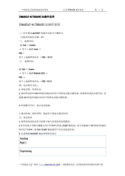
3.注意观察 HANDSET液晶屏将依次显示SendingPage 1NegotiatingFaxLESconnectedFaxFaxConnectedFaxcalling4.接通用户后,传真机液晶屏上显示 send page xG3 等字样。
5. 文件全部发完后,显示窗显示 TRANSMITINGOK,传真发送完毕。
6.HANDSET 液晶屏上将显示发送时间。
船舶设备操作规程 编号:0722-07-2146版次:03 卫通 M 站操作说明页次:17 附2 * 本传真在接受传真时无铃声提示,平时注意查看接受。
六、查看通讯记录:按 2nd→ 1menu→ 用↑↓选择 Call log →OK →用↑↓选择并查看记录 → EXIT七、查看通讯总时间:按 2nd→ 1menu→ 用↑↓选择 Calls total →OK →屏幕上将显示 Total time → EXIT。
船舶关键性设备操作指南(甲板部驾驶台设备部分)海事检查要点

2、操作程序
(1)电源供电转换至备用电源,以确定备用电源的供电状况。 (2)在 SSB 模式下检查天线自动调谐功能状态,转换不同频段的各种频率,确定天线自动 调谐器都能在 MF 和 HF 整个波段内能否自动调谐,并达到最佳状态。如果未发出调谐声或 调谐声无法自动停止,说明天调故障。天调故障意味信号变弱,功放不匹配,功耗增大,工 作时间一长会烧损功放。 (3)选择近、远距离的岸台,选用与距离相适应的岸台工作频率,通话询问对方所接收到的 信号强度,以判别设备的收发性能。 (4)进入 SSB 模式主菜单中“SELF SET 系统设置”子菜单的下一级菜单“SELF TEST”进行 自检,自检“Receive 接收机” 、 “ Watch 值守 ” 、 “ Exciter 激励器” 、 “ Tuner 调谐器”四 个功能,如各单元功能显示为“ good”表示通过自检,为“Error” 表示未能通过自检。 但需注意“Gain 增益调整”旋钮调至过小时, “Receive 接收机”会出现自检通不过情况, 需调至适当位置,重新进行自检。 (5)通过“system setting”子菜单下级子菜单“self-ID Sets 本船 ID 码设置”中,查看
(6)如果要群发信息,在第 3)步选择(Write Broadcast SRM) ,做群发信息; (7)编辑信息内容,按(Sends)键发送。 注意:如果按(Back)键将返回导航界面而不发送信息。 (8)信息传送后,信息传送显示屏会显示发送状态。
4 AIS 实操检查表
序号 1 2 3 4 5 6 7 8 检 查 项 目 是否熟悉各功能键的作用 是否熟悉AIS开机步骤 是否熟悉各静态数据的输入 是否熟悉各动态数据的输入 船员是否熟悉信息的编辑及发送 船员是否熟悉信息的阅读 是否熟悉 TCP 和 TCPA 的设置 是否熟悉目标船信息的获取 是 否 备 注
海船通用G证实操手册

GMDSS 实操手册NAVIGATION,IT IS AN ENTERPRISE OF BRAVE MAN!航海,是勇敢者的事业!SSB FS-5000 基本操作一、控制单元1.开关机1) 开机:按POWER 一秒以上2) 关机:同上2 屏幕亮度、对比度调整1) 亮度:DIMMER ,调整键盘照明;2) 对比度:CONSTRAST ,调整字符与背景的清晰度.3. 时间:按CLOCK 键,输入时间,按STOP,再按一下CLOCK键.4. 工作种类选择1) SSB :电话通信2) TELEX :电传 3)*CW :人工莫尔斯报*每按一次显示一种5. 经纬度显示:外接GPS.6. 工作种类的中心频率1) FAX :BFO[1900]2) TELEX :BFO[1700]二、电台收发频率的设置(一)查看海岸电台表1、 R/T:无线电话频率1)看时间,找频率,查到的频率是接收频率,所以输入时要换成发射频率;AGC 开启开关 AGC 档位选择SLOW 、FAST2)查接收通波表:在表的下面最后一行,时间是H+10',例1h10'、2h10''等2、RADIOTELEX:电传频率——同电话(二)船台频率的输入:发射频率(TX)≤接收频率(RX)1、直接输入法1)设置工作种类SSB/TELEX2)查表后输入发射频率和接收频率TX键→输入频率→按ENTER 键RX键→输入频率→按ENTER 键2、调用国际信道法(ITU)1)设置工作种类:SSB/TELEX2)调用:ITU键→信道号(例818)→按ENTER 键三、接收机的调整1.设置工作方式: SSB或TELEX1)电话通讯按:SSB单边带电话找H24(全天使用)2)电传通讯按:TELEX 中心频率1700 要知道BFO注意:船台发送频率小于接收频率TX<RX 操作如下:TX→频率→ENTERRX→频率→ENTER*TRAFFIC LIST(通播表) 里面的频率设在我台的接收频率上2.设置接收频率:直接输入法或ITU法3.通断扬声器:选择话筒或扬声器4.调节音量:按VOLUME的▲▼(刚开始时调大点,通信过程中调到适中)5. 调节灵敏度:按SENSITIVITY的▲▼(调到信号最佳,噪声最小,同时观察SEN表和S表)6. 设置AGC的参数:用于信号强度的均衡,增强弱信号,减弱强信号1)通常设:SLOW 2)远距离、信号弱时关闭:OFF(AGC) 3)双工通信、外干扰强时设:FAST7. 选择接收带宽(频带宽度):SSB 3KHZ ; TELEX 0.3KHZ8. 静噪电路SQ:用于抑制机内噪声,一般开启,信号弱时关闭9.消噪电路NB:用于抑制外部强脉冲干扰,平时可开可关,外界干扰大或双工时开启10.接收频率4.5MHz以下的信号微调:只有在RX<4.5MHz时才有用。
国际航行船舶舱单申报系统用户操作手册-中国(广东)国际贸易单一窗口

国际航行船舶舱单申报系统用户操作手册广东电子口岸2017 年7 月目录第一篇前言 (4)第二篇使用需知 (5)第三篇舱单申报介绍 (6)功能简介 (6)术语定义 (6)重要提醒 (7)∙关于界面 (7)∙关于键盘操作 (7)第四篇进入系统 (9)第五篇通用功能 (10)∙折叠/展开菜单 (10)∙关闭选项卡 (10)∙必填数据与选填数据的标识 (10)∙日期、时间选择 (11)∙自动填充下拉选择框 (11)第六篇国际航行船舶舱单单证 (13)第一章原始舱单 (13)1.1原始舱单录入 (14)1.2原始舱单操作 (18)第二章预配舱单 (23)2.1 预配舱单录入 (23)2.2 预配舱单操作 (25)第三章理货报告 (26)3.1进口理货录入 (26)3.2进口理货操作 (27)3.3出口理货录入 (28)3.4出口理货操作 (30)第四章出口运抵 (31)4.1(集)出口运抵报文录入 (31)4.2(集)出口运抵报文操作 (32)4.3(散)出口运抵报文录入 (33)4.4(散)出口运抵报文操作 (34)第五章装载舱单 (34)5.1 装载舱单录入 (34)5.2 装载舱单操作 (36)第六章分拨/分流申请 (36)6.1分流申请录入 (36)6.2分流申请操作 (37)6.3分拨申请录入 (38)6.4分拨申请操作 (39)第七章分流/分拨运抵 (40)7.1(集)分流/分拨运抵录入 (40)7.2(集)分流/分拨运抵列表 (41)7.3(散)分流/分拨运抵录入 (42)7.4(散)分流/分拨运抵列表 (43)第八章直接/落装改配 (44)8.1直接改配录入 (44)8.2直接改配列表 (45)8.3落装申请录入 (46)8.4落装申请列表 (47)8.5落装改配录入 (48)8.6落装改配列表 (50)第九章进口改靠港 (51)9.1进口改靠港录入 (51)9.2进口改靠港列表 (52)第十章空箱调运 (53)10.1进口空箱调运录入 (53)10.2进口空箱调运列表 (54)10.3出口空箱调运录入 (55)10.4出口空箱调运列表 (56)第十一章国际转运 (56)11.1国际转运录入 (56)11.2国际转运列表 (57)第十二章系统管理 (58)第一篇前言为配合海关总署令第172号《中华人民共和国海关进出境运输工具舱单管理办法》(以下简称“舱单管理办法”)对进出口运输工具及其装载货物的管理要求,广东省电子口岸对广东国际贸易单一窗口系统进行了升级,增加了国际航行船舶舱单申报系统(以下简称“舱单系统”),舱单系统涵括了舱单管理办法中规定的全部内容,其中包括反映进出境船舶装载货物、物品的货物舱单模块和舱单相关数据模块,码头作业相关的运抵和理货模块,以及反映航行动态情况的运输工具管理模块。
船舶数据终端操作维护手册

船舶数据终端操作维护手册一、船舶数据终端概述CGSDT-9200船舶数据终端是由北京兴兴交通通信工程技术公司自主研发的基于VHF的内河水上数据通信的船舶终端产品。
船舶终端具备数字安全信息广播、船舶遇险报警、船舶动态轮询、船舶短信息、双向邮件传输、自动入退网等功能。
设备的各项控制功能和设置均在液晶显示器上以中文方式显示,操作简单、直观;本终端配置的行式热敏打印机,打印速度快、故障率低。
适用于各类船只自动接收并打印由电台播发的有关长江安全航行警告信息和专用信息。
全功能型船舶终端与PC机相连后,可以实现船岸之间的数据通信,如船与岸双向邮件业务,船与船双向短消息业务等。
还可通过船舶终端的客户端软件监控本船舶及周围船舶的航行动态,确保船舶航行的安全。
船舶数据终端有两部分组成,即终端显示控制单元与传输模块。
显示控制单元部分包括显示单元、打印单元、操作控制单元、GPS模块、外围接口电路等;传输单元包括VHF电台、电源模块、VHF天馈线。
地址:北京安外外馆后身一号1.1、 C GSDT-9200船舶数据终端前视图1.2 船舶数据终端显示单元前视图。
图1 船舶数据终端前视图地址:北京安外外馆后身一号1.3 CGSDT-9200船舶数据终端显示单元后视图船舶数据终端显示单元后视图1.4 按键功能介绍:按键布局图地址:北京安外外馆后身一号按键功能列表:按 键 含 义 功 能电 源 电源打开/关闭 按住电源键3秒,船舶数据电源打开/关闭 走 纸 进纸 打印机向前走纸,每按一次打印机走一行纸菜 单 功能菜单 进入船舶数据控制菜单功能状态或由子菜单返回主菜单选择/确认 激活/抑制 按此选择键可以交替进行激活和抑制的选择报警声关 消除报警 当接收到报警类信息及打印机缺纸时,发出音响报警,按消警键消除警报退出 退出 退出系统菜单报警1 报警组合键1 报警2 报警组合键2 同时按下报警组合键1和组合键2三秒钟,船舶数据终端自动发送遇险报警信息过闸申请 过闸业务申请键当船舶航行到系统设定的库区范围内,过闸申请键3秒钟,船舶数据终端自动发送过闸申请信息测试 自检 设备自身检测Δ▽上 移下 移在菜单功能下,上下翻看子菜单及功能选项 地址:北京安外外馆后身一号二、操作说明:2.1 开\关电源z关机状态下,持续按下数据终端 电 源键三秒,开启电源。
船舶地面站操作手册驾驶室仪器操作规程

INMARSAT-C船舶地面站操作规程
INMARSAT船舶地面站操作规程
中/高频/SSB无线电装置操作规程
甚高频无线电装置操作规程
高频无线电装置操作规程
NVATEX航行警告接收机操作规程
气象传真机操作规程
AIS船用全球自动识别系统操作规程
回声测深仪操作规程
GPS接收机操作规程
自动操舵仪操作规程
电罗经操作规程
磁罗经操作规程
电磁记程仪操作规程
VDR船载航行数据记录仪操作规程
操作规程
注意事项备注
双向无线电话操作规程
SART 操作规程
EPIRB 操作规程
INMARSAT-F 操作规程
RADAR 雷达操作规程
RADAR雷达操作规程
雷达操作规程
舵机操作程序
1、通知机舱舵机供电。
2、打开舵机开关,选择舵机组。
3、选择操纵方式,随动方式。
4、转动舵轮试验舵角指示。
5、最后舵角指示回零。
6、舵机备好。
应急舵操作规程。
船舶配载系统使用说明书
船舶配载系统使用说明书船舶配载系统使用说明书一、前言1.1 您好,感谢您使用船舶配载系统。
本系统为航运公司提供便捷高效的配载服务,节省了大量人力和物力成本,是目前航运行业一款非常优秀的系统。
1.2 本系统操作简单方便,但是在使用前,您需要进行帐号注册和登录操作。
二、系统注册和登录2.1 进入系统注册页面,填写相关信息,包括公司名称、公司地址、负责人姓名、联系电话、邮箱等信息,完成注册后,系统将审核账户信息并发送激活邮件到您的邮箱中,请按照邮件指示进行激活操作。
2.2 注册完成后,您需要进行登录操作,输入您的账户名和密码,点击登录即可进入系统的主界面。
三、系统主界面使用说明3.1 在系统主界面,您可以选择船公司、航线、港口、船舶等信息,进行配载操作。
3.2 系统支持智能配载,根据货物种类、重量等信息自动匹配最适合的船舶进行操作。
3.3 您可以根据货物种类、重量、航线等信息进行查询和修改操作,并随时了解到货物的配载情况和船舶运行状态。
3.4 配载操作完成后,您可以进行打印或者发送配载清单等操作。
四、系统维护和技术支持4.1 为保证系统的稳定运行,系统将定期进行维护和升级操作,请您在使用过程中保证网络畅通。
4.2 如果您在使用过程中遇到任何问题,请联系我们的客服人员进行解决,我们会提供快速的技术支持。
五、系统安全保障5.1 我们重视用户隐私和商业机密的保护,系统将采用专业的安全技术确保数据的安全性,同时展现高效可靠的配载服务。
5.2 建议用户在使用系统时,采取一定的保密措施,避免信息泄露和造成的经济损失。
以上就是船舶配载系统使用说明书的相关内容,希望对您使用该系统有所帮助,谢谢!。
VTS(船舶交通服务)操作手册说明书
1151 INTRODUCTIONIn the era of e ‐Navigation, the future VTS(Vessel Traffic Services) is anticipated to play an important role on the enhancement of maritime safety and the efficiency of maritime transport as a key stakeholder of e ‐Navigation. To enhance VTS services, VTS operator needs the advanced functions to support the VTS Services.In the IMO Resolution A.857(20), the three services for VTS are defined (IMO. 1997a), i.e., INformation Service(INS), Navigational Assistance Service(NAS), and Traffic Organization Service(TOS). Among them, the TOS concerns the operational management of traffic and the forward planning of vessel movements to prevent congestion and dangerous situations, and is particularly relevant in times of high traffic density or when the movement of special transports may effect the flow of other traffic. The TOS is a service to prevent the development of dangerous maritime traffic situations and to provide for the safe andefficient movement of vessel traffic within the declared VTS area. It also includes establishing priority of movements, allocating space, routes to be followed, speed limits to be observed or other appropriate measures which are considered necessary by the VTS authority (IALA. 2012a). Taking into the IALA VTS strategy paper account (IALA. 2012b), it is expected that the future VTS focuses on further development of TOS in its operation. In the 35th session of IALA VTS committee, the draft guideline on the provision of VTS Type of Service was finalised (IMO. 2012b). In contrast to a general definition of TOS in A.857 (20), the VTS draft guideline defines concrete services for TOS (IALA. 2012c). On the other hand, various roles of e ‐Navigation stakeholders are included in its architecture specification process (IMO. 2012b), i.e., the roles for master, pilot, and VTS. In this paper, the VTS functions to support its TOS are revisited, considering the reports of e ‐Navigation strategy and IALA VTS committee. Several functions to support the TOS are exemplified. Such functionsFunctional Requirements to Support Traffic Organization ServiceJ.S. Jeong & G.K. ParkDepartment of Maritime Transportation System, Mokpo National Maritime University, Mokpo City, Republic of KoreaABSTRACT: In the era of e ‐Navigation, the future VTS is anticipated to play an important role on the enhancement of maritime safety and the efficiency of maritime transport as a key stakeholder of e ‐Navigation. The VTS services need the advanced Traffic Organization Service(TOS). In this paper, the VTS functions for TOS is revisited from the reports of IMO e ‐Navigation Correspondence Group and IALA VTS Committee. In Korea, the research activities to enhance the existing VTS functions have been conducted. In terms of TOS, some VTS functions have been developed. In conclusion, all the past traffic data and real ‐time ship data are required to provide the advanced TOS. For this, the advanced functions to support TOS should be implemented on VTS console.http://www.transnav.euthe International Journal on Marine Navigationand Safety of Sea TransportationVolume 7Number 1March 2013DOI: 10.12716/1001.07.01.15need to be presented on the VTS console for an effective VTS operation.2TRAFFIC ORGANIZATION SERVICES FOR VTS 2.1Functions to be carried out in the era of e‐Navigation In e‐Navigation, a stakeholer – a person or an organization – may have several different responsibilities. All functions to fulfil the responsibilities may be carried out by persons or systems, or a combination of both (IMO. 2012b). The functions are sorted by stakeholders, i.e, master, pilot, tug service providers, shore organizations. Table 1 represents main functions to be conducted by a stakeholder (IMO. 2012b).Table 1. Functions to be conducted by a stakeholder._______________________________________________Stakeholders Functions_______________________________________________ Master Support and Control NavigationSafe NavigationManagement of InformationSupport to Incident Handling andEmergency ManagementSupport Maritime SecurityPilot Prepare PilotageConduct PilotageOn shore Fairway Utilization PlanningVessel Traffic ServicesPort Operation SupportEmergency Management_______________________________________________In Table 1, all the functions of stakeholders contain their sub‐functions. Several sub‐functions need to be supported by shore organization, such as VTS. For example, the function, Support and Control Navigation, requires to use shore‐based information services, i.e, Maritime Safety Information(MSI) Service, Routeing Information Service, Hydrographic Information Service, Ice Information Service, Port Authority Instruction, Meteorological Information Service and Warning so on.It is natural that each function is also interrelated to other function. The function, Vessel Traffic Services, includes ‘Monitor High Seas’, ‘Manage VTS’, ‘Manage Tracking Information’, ‘Operate Ship Reporting System’, ‘Exchange Information with Relevant Authorities’, ‘Exchange Information on Emergency’. The TOS is a crucial service for the effective management of VTS. In the era of e‐Navigation, the VTS require an intelligent TOS which contains the following sub‐functions:-Plan Traffic Flow-Plan Traffic Organization Criteria-Monitor Traffic Situation and Prediction -Decide on Priority – e.g. allocation of time slots2.2IALA VTS Traffic Organization ServicesIn the 35th session of IALA VTS committee, the draft guideline on the provision of VTS Type of Service was finalised and is supposed to be delivered to the IALA Council for approval (IALA. 2012d). As mentioned in the IALA VTS Strategy Paper (IALA. 2012b), the TOS will be further developed over the next 10 to 20 years. It is expected that the future VTS operation focuses on the delivery of the advanced TOS. The IMO Resolution A.857 (20) states that a VTS should at all times be capable of generating a comprehensive overview of the traffic in its service area combined with all traffic influencing factors. To respond the traffic situations developing in the VTS area and to determine appropriate actions, the acquired data should be processed and evaluated. As mentioned in Section 1, the TOS is a service to prevent the development of dangerous maritime traffic situations and to provide for the safe and efficient movement of vessel traffic within the declared VTS area. The draft guideline suggests the cases that the TOS should be provided as follows (IALA. 2012c).-vessel movements need to be planned or prioritised to prevent congestion or dangerous situations;-special transports or vessels with hazardous or polluting cargo may affect the flow of other traffic and need to be organised;-an operating system of traffic clearances or sailing plans, or both, has been established;-the allocation of space needs to be organised;-mandatory reporting of movements in the VTS area has been established;-special routes should be followed;-speed limits should be observed;-the VTS observes a developing situation and deems it necessary to interact and coordinate vessel traffic;-nautical activities (e.g. sailing regattas) or marine works in‐progress (such as dredging or submarine cable‐laying) may interfere with the flow of vessel movement.Here is an example of the TOS information with relation to waterway management (IALA. 2012c).-The use of one way traffic as an alternative of two way traffic, depending on the dimensions of ship or the weather conditions;-Organising other traffic when a vessel has passed point of no return;-Slot management to allocate ships in a time window;-Organising the traffic concerning vessel dimensions in comparison to fairway restrictions; -Instruct vessels when overtaking is not permitted; -Establish and organise ship safety zones in case of particular operations;-Establish and organise exclusion zones;-Instruct vessels to keep clear from special areas/positions;-Organising the traffic as regards to meteorological, hydrographical or other restrictions such as visibility, wind speed, current, sea state, and under keel clearance.1161173 VTS FUNCTIONS TO SUPPORT TOS 3.1 Examples of Functions for TOSTo provide the TOS, as mentioned in section 2.1 and 2.2, the VTS requires further information, which is obtainable by implementing the following functions. - Ship Reporting System(SRS), Sailing Plan (SP) and information transfer among authorities and ship. - Calculation of traffic congestion rate in the water ‐area of interest- Decision ‐making for collision avoidance - Monitoring of ship trajectories- Risk assessment in the water ‐area of interest.3.2 Ship Reporting System, Sailing Plan, andInformation TransferThe information which is collected from SRS contains ship particulars, ship’s draft, spatial and temporal information of ship movements, cargo type. Such information may be utilised to organise the ship or other ships in a fairway, to allocate the ships in a time window, and also to keep clear from special areas/positions so on. The SP may be used to provide various services belonging to TOS, i.e, wateway management and collision avoidance etc.3.3 Calculation of Traffic Congestion Rate in theWaterarea of interest Large part of the TOS may be conducted by predicting the direction of traffic flow and its volume. All information from SRS and/or SP may be used not only to predict such traffic flow prediction, but also to predict the area to be congested. The static and dynamic information from non ‐AIS ships should be combined with all the information from SRS and SP.Figure 1. Lateral distribution of Traffic along a fairway.The lateral distribution of traffic helps not only to understand traffic flow direction but also to mitigate the congestion by allocating traffic route. In addition to the spatial distribution of traffic, the speed distribution can be also used to calculate the traffic congestion rate in a time window as well as in the special area. The traffic congestion rate may be simply calculated from the ratio of the total ship bumper areas over the total waterarea in a fairway. However,the ship speed affects the number of ships in a fairway and the distance among ships. To obtain more practical congestion rate, it is realistic to consider the other parameters including ship particulars, ship dynamic conditions, courses, weather, sea state. The calculation of traffic congestion rate is open. Figure 1 shows the lateral distribution of traffic which is obtained from the data collected along a fairway. The lateral distribution in a fairway can be plotted at arbitrary gateline of interest. Figure 2 represents the distribution of ship speed at the observed area or a fairway. From the speed distribution, the average and standard deviation of speed are calculated. The standard deviation of speed will affect a navigational safety in waterarea. The speed distribution can use to determine the safe speed or the speed limit criteria.Figure 3 shows CPA distribution as TCPA varies with time at the waterarea of interest. The CPA is normalized by the major diameter of an elliptic model for ship bumper area (A.G. Frandsen. 1991). In Figure 3, the red dot line means the boundary of ship safe domain. If a vessel enters into the boundary of target vessel, the two vessels may be in danger.Figure 2. Ship Speed Distribution.Figure 3. CPA variation as a function TCPA.3.4 Risk Assessment and Decision ‐Making for CollisionAvoidance Several risk assessment models have been proposed to represent real ‐time collision risk among multiple encountered vessels in a water ‐area (Y.S. Park et.al.2012). The collision risk, which is calculated by method proposed in (Y.S. Park et.al. 2012, N.S. Nam & S.Y. Kim, 2012), may be used as a reference index to support decision‐making for collision avoidance in VTS or ship. On the other hand, the other models assess statistical risks by using the past ship movement data (Jun Min Mou. et al. 2010, Jakub Montewka. et al. 2010, J.S. Jeong. et.al. 2012). Figure 4 shows the variation of causation factor which is calculated by using AIS data for the last 72 hours (J.S. Jeong. et al. 2012) in WANDO waterway of Korean Southwestern coast. The causation factor is called the probability of failing to avoid a collision when the encountered vessels are on a collision course (Jakub Montewka. et al. 2010). In fact, it is difficult to assess the maritime risk by causation factor itself. The value of causation factor may be used as reference index for design of traffic lane, determination of speed limit and fairway width so on. The proper range of causation factor depends on natural environments including weather, geographical conditions.Figure 4. Variation of C P for 72 hours.4CONCLUSIONSIt is expected that the TOS plays an important role on the future VTS operation. Herein, the VTS functions in the e‐Navigation architecture and IALA draft guideline on the provision of VTS Type of Service were revisited. To support the advanced TOS and the decision‐making for effective and safe waterway management, several examples were illustrated. The information from ship reporting system and sailing plan may be utilized to organise the ship or other ships in a fairway, to allocate the ships in a time window, and also to keep clear from special areas/positions so on. The traffic congestion level is useful for the dynamic assignment of traffic lane and width, and even speed limit. The maritime risk index also helps to manage traffic effective and safely and to design traffic lane and capacity.To take a proactive measures for maritime safety and prevention of oil pollution, the advanced functions on VTS console should be implemented.ACKNOWLEDGMENTThis research was a part of the project titled “Development of the Intelligent Technology for Marine Accident Protection & Salvage” funded by the Ministry of Land, Transport and Maritime Affairs, Republic of Korea.REFERENCESIMO. 1997a. Guidelines for Vessel Traffic Services, Resolution A.857(20).IALA. 2012a. VTS Manual 2012 Ed.5: 50.IALA. 2012b. Strategy paper addressing the delivery of VTS in a rapidly changing world, VTS35/output/2.IALA. 2012c. Guideline on Provision of Vessel Traffic Services(INS, NAS, TOS), Ed.1.IMO. 2010b. Development of an e‐Navigation Strategy Implementation Plan, Report of the Working Group, NAV 56/WP.5.IALA. 2012d. Report of the 35th Session of the IALA VTS Committee.A.G.Frandsen. 1991. Evaluation of Minimum Bridge SpanOpenings – Applying Ship Domain Theory, Transport Research Record No.1313, Pub. No. 743B: pp.85‐86.Y.S. Park. J.S. Kim. J.Y. Jung. J.S. Jeong. & G.K. Park. 2012. A Study in the maritime safety model in Korea, ENC 2012, 25‐25 April, Gdansk, Poland.N.S. Son. S.Y. Kim. C.S. Lee. 2012. On the Monitoring System of Collision Risks among Multiple Ships, ENC 2012, 25‐25 April, Gdansk, Poland.Jun Min Mou. Ceesvander Tak. & HanLigteringen. 2010.Study on collision avoidance in busy waterways by using AIS data, Ocean Engineering (37): 483‐490.Jakub Montewka. Tomasz Hinz. Pentti Kujala. & Jerzy Matusiak. 2010. Probability modeling of vessel collisions, Reliability Engineering and System Safety (95): 573‐589.J.S. Jeong. K.I Kim. & G.K. Park. 2012. Risk Assessment Model of Maritime Traffic in Time‐Variant CPA Environments in Waterway, Journal of Advanced Computational Intelligence and Intelligent Informatics 16(7).118。
- 1、下载文档前请自行甄别文档内容的完整性,平台不提供额外的编辑、内容补充、找答案等附加服务。
- 2、"仅部分预览"的文档,不可在线预览部分如存在完整性等问题,可反馈申请退款(可完整预览的文档不适用该条件!)。
- 3、如文档侵犯您的权益,请联系客服反馈,我们会尽快为您处理(人工客服工作时间:9:00-18:30)。
【精编推荐】CombineUserGuide船舶M站操作手册AMOSConnect(7.4.27) – Quick User Guide (EnglishVersion)Table of ContentChapter 1 – Connection between Inmarsat and PC…..……. Page3Chapter 2 - AMOSConnect Quick Installation…………..... Page 42.1 – Verify Connection Page 5Chapter 3 –AMOSConnect simple user guide...………….. Page 73.1 – Start AMOS Connect Page 73.2 – Editing address books Page 73.3 – Compose new email Page 103.4 – Compose FAX (Text Only) Page 143.5 – Compose FAX (Attachment) Page 163.6 - Compose Telex Page 183.7 – Dial and connect Page 203.8 – Check connection status Page 22Chapter 4 – FAQ Session..………………………………... Page 23Appendix I ……………………………………………….. Page 36Important Note:After install AmosConnect, please make sure you backup the folder C:\AM32\AMPO (or C:\AMPO) at least once per month, so you could recovery all your AmosConnect setting and history in case you PC have technical problemHow to Backup AmosConnect and Reinstall in New PC1.Copy the folder C:\AM32\AMPO ( the mail path folder could be found in Help/aboutAmosConnect) at least once per month to other PC or Hard Disk2.If PC with AmosConnect have problem, copy the AMPO folder to the new pc3.Install AmosConnect version 7.4 by click AC-7.4.16 (Setup.exe) from you AmosConnect CD ,the Setup.exe is in the source folder , don’t use setup.bat unless you want to install newdatabase4.After installation , click “Connect to existing post office”5.Chose Local Database and browse to the folder of AMPO6.In C:\Am32, or C:\program file\AmosConnect, find out file “ ResetDeviceComputer.exe “ anddouble click it ( to reset the modem driver)7.Your AmosConnect should be fully recoveredChapter 1 – Connection between Inmarsat and PCInmarsat B:Inmarsat Mini-M:Inmarsat F (RS232 Direct Connection):Inmarsat F( With ISDN TA):ComputerInmarsat B Terminal (DTE Port)(9 Pin COM Port)ComputerMini-M Terminal (9 Pin Data Port)(9 Pin COM Port)Computer(9 Pin COM Port)Inmarsat-F Terminal(ISDN Port)ISDN LineISDN TA Serial LineFAX MachineTelephone(9 Pin or 25 pin )Computer(9 Pin COM Port)Inmarsat-F Terminal(RS232 Port)RS232 SerialFAX MachineTelephoneChapter 2- AMOSConnect Quick installation1.Place AMOSConnect CD in the CDROM drive2.Double click to open ”My Computer” on desktop3.Double click on CD-ROM drive4.Double click “Setup”, a window will pop up, keep waiting during the installation untilyou see the message ‘AMOS-Mail restored. Please try to run AMOS Connect andconfirm’5.After installation has been completed, the window will close automatically.6.For Re-Installation, follows these steps :a)Remove “AMOS Connect” under “Add/Remove Programs” in “Control Panel”b)Delete the whole directory C:\am32c)Start installation from step 12.1 Verify Connection1.Double the icon ‘AMOS Connect’ on desktop2.Click the ‘Dail’ button, follow by the ”Connect” button3.If no error message pop up and you can see statistics count , that means the connection is inprogress.Now, you can start to use AMOS Connect.4.If error message pop up or you cannot make a connection, please refer to Chapter 4 – FAQ Sessionfor troubleshoot for troubleshootChapter 3 – AMOSConnect simple user guide3.1 Start AMOS Connect1.Double click the icon ‘AMOS Connect’ on desktop3.2 Editing Address Books (E-mail, Fax and Telex Service)2.Click the ‘Address’ button, the ‘Address Book’ window will pop up3.Click the ‘New’ button, the ‘New Directory’ will pop up4.Adding contacts in Address Book :a.Adding Email address:i.Select ‘Internet’ in the ‘Template’ pull-down menuii.Input the email address in the Address. (e.g. The Email address is service@ as shown in the following example)b.Adding FAX number:i.Select ‘Fax” in the ‘Template’ pull-down menuii.Input the fax number in the Address. (e.g. The fax number is +852******* as shown in the following example)c.Adding telex number:i.Select ‘Telex’ in the ‘Template’ pull-down menuii.Input the telex number in the Address. (e.g. The telex number is +8533103 as shown in the following example.)3.3 Compose new email1.Click the ‘New’ icon at top-left hand corn, the ‘New Message’ and ‘Address Selection’ windowswill pop up2.Click to select the recipient, click ‘T o’, ‘Cc’ or ‘Bcc’ to put it on the list3.Click ‘Close’ when finish4.Enter the subject and content for the email5.Click ‘Attach’ button if you want to add attachment, the ‘Add Attachment(s)’ window will pop up6.Find and click on the target file, click ‘open’.7.The attachment will be put into the new message8.Click the ‘Send’ button9.The email will be put in ”Send Queue”, pending for delivery10.The email will also make a copy in “SendBox” for record3.4 Compose FAX - Text Only, only send FAX with English content 1.Click the ‘New’ button, the ‘New Message’ and‘Address Selection’ windows will pop up2.Click to select the recipient, click ‘To’, ‘Cc’ or ‘Bcc’ to put it on the list3.Click ‘Close’ when finish4.Enter the subject and content for the email5.Click the ‘Send’ button3.5 Compose FAX - Attachment method, can be used with any printing-capable software1.Start AMOS Connect2.Under any printing-capable software, select ‘AMOS Fax’ for printing. For example : FAX under“MS Word” document :3.Print the document, select to use the printer “AMOS-Mail Fax”4.After press “OK” , The document will be sent to ‘AMOS Connect’ , select the recipient list andpress the ‘Send’ button to send it3.6 Compose Telex1.Click the ‘New’ button, the ‘New Message’ and ‘Address Selection’ windows will pop up2.Click to select the recipient, click ‘To’, ‘Cc’ or ‘Bcc’ to put it on the list3.Click ‘Close’ when finish4. Enter the subject and content for the email。