钓鱼岛是中国的固有领土白皮书(英文版,全文)
宁夏中卫市2024生物七年级上册第一单元《生物和生物圈》人教版质量检测模拟卷

宁夏中卫市2024生物七年级上册第一单元《生物和生物圈》人教版质量检测模拟卷学校:_______ 班级:__________姓名:_______ 考号:__________(满分:100分时间:60分钟)总分栏题号一二三四五六七总分得分评卷人得分一、选择题:本大题共30小题,每小题2分,共60分。
在每小题给出的四个选项中,只有一项是符合题目要求的。
1.关于生物特征的说法,正确的是()A.“红豆生南国,春来发几枝”体现的是生物能生长B.“蜻蜓点水”体现的是生物能排出废物C.“龙生龙,凤生凤”体现的是生物有变异的特征D.“螳螂捕蝉,黄雀在后”体现的是生物能进行呼吸2.新型冠状病毒肺炎简称“新型肺炎”,是指由新型冠状病毒导致的肺炎。
判断新型冠状病毒属于生物的主要依据是( )A.由细胞构成B.能够产生自己的后代C.能够使人患病D.能够随空气、飞沫传播3.你刚学过有关“生物”的知识,请你判断下列说法正确的是( )A.凡是能够由小长大的物体就是生物B.生物都由细胞构成C.生物能够由小长大D.动物能产生废物,植物不产生废物4.下列属于生物的是( )A.生物课本B.电脑病毒C.钟乳石D.兔子5.你知道哪些是生物,哪些是非生物吗?请你选出下列一组都属于生物的是()①珊瑚②珊瑚虫③钟乳石④克隆羊⑤机器人⑥衣藻⑦珍珠⑧新冠病毒A.①②③④B.⑤⑥⑦⑧C.②④⑥⑧D.①③⑤⑦6.骆驼刺是一种落叶灌木,地上部分矮小,但根系发达,长度可达20米。
通过上述信息可判断影响骆驼刺生存的最主要的因素的是()A.光B.温度C.水分D.空气7.下列生态系统中,自动调节能力最强的是( )A.罗平油菜花田B.会泽大海草山C.西双版纳热带雨林D.沾益海峰湿地8.下列关于生物与环境的叙述,错误的是()A.环境是指生物的生存地点B.生物既受环境影响,也能影响环境C.荒漠中的骆驼刺根系非常发达,体现了生物能够适应环境D.“人间四月芳菲尽,山寺桃花始盛开”体现了环境对生物的影响9.生态系统能够保持相对稳定的主要原因是( )A.人类的精心维护B.生态系统的物质循环利用C.食物网中的各种生物之间的相互依赖、相互制约D.受四季更替作用的影响10.下列属于生态系统的是( )A.一条河流B.一块农田中的所有农作物C.一个湖泊中的水D.草原上所有的牛和羊11.下列关于生物的描述中,不正确的是( )A.生物都能生长B.生物有变异现象C.病毒不是生物D.生物可以呼吸12.苏辙有“苦寒坏我千竿绿,好雨还催众笋长”的诗句。
高考政治维护世界和平练习试题

2017年高考政治维护世界和平练习试题单选题21世纪头十年,金砖国家整体经济平均增长率超过8%,远高于发达国家2.6%的平均增长率及4.1%左右的全球平均增长率。
金砖国家对世界经济增长的贡献率在2010年超过60%。
金砖国家已成为拉动全球经济增长的火车头。
这表明( )①世界多极化趋势不可逆转②国际政治经济新秩序已经建立③世界上正在形成若干个政治经济力量中心④综合国力成为国际关系的决定因素A.①②③B.①③④C.②④D.①③党的十六大以来,中国坚持走和平发展道路,推进建设和谐世界,赢得了世界各国的理解和赞誉。
我国始终不渝走和平发展道路,其根本原因是( )A.和平与发展两大时代主题的要求B.我国国家性质和国家利益所决定的C.缓解世界矛盾和紧张态势的需要D.中国是负责任的发展中大国下列能同时体现我国外交政策的基本立场和主权国家的权利的选项有( )①海地发生强烈地震后,包括中国在内的40多个国际医疗队投入救援行动②中国呼吁朝韩双方冷静对待冲突,重启六方会谈,恢复东亚地区的和平③针对钓鱼岛冲突,我国政府向日方表明:原则不可退让,神圣领土决不放弃④德班气候峰会,中国坚持自主自愿减排“不动摇”,并团结发展中国家开展维权斗争A.①②B.②③C.①④D.③④假如让你写一篇集中反映中国2012年度外交活动的专稿,需要确定一组体现中国外交主张的“关键词”,请结合政治生活知识,从下列选项中选出最准确的一组( )A.独立自主和平共处文化渗透B.和平发展战略结盟我国的独立和主权C.多边外交和平发展负责任的大国D.经济全球化政治多极化文化多元化2012年中国外交布局将围绕“五条主线”展开:积极运筹与世界大国关系,努力增进与周边国家的睦邻友好关系,继续夯实与发展中国家的关系基础,努力用好多边外交舞台,大力发展公共外交,努力维护和延长中国发展的重要战略机遇期。
这说明我国( )①坚持独立自主的和平外交政策②中国在国际事务中发挥建设性作用③坚持多边外交、促进世界和平与发展④重视巩固大国间的合作联盟关系A.①②B.③④C.②③D.①③“和谐世界”是新一代中央领导集体对新时期我国外交政策目标的新概括。
四川广安华蓥市农业农村局招考聘用市级专职渔政协助巡护人员冲刺题(二)

四川广安华蓥市农业农村局招考聘用市级专职渔政协助巡护人员冲刺题(二)1、单选题推动社会变革最根本的动力是_____。
A : 生产力和生产关系的矛盾运动B : 生产力的发展C : 生产方式的变革D : 经济基础和上层建筑的矛盾运动参考答案: A本题解释:【答案】A。
解析:推动社会经济制度变革最根本的动力是生产力和生产关系的矛盾运动。
其中,生产力是最活跃的因素,是决定生产关系变化的根本原因。
第 1 题所属考点-《政治经济学》2、单选题关于中国地理,以下说法正确的是_____。
A : 中国地势西高东低,大致呈四大阶梯状分布B : 长江流域面积小于黄河流域面积,但是水资源总量大于黄河流域C : 冲国几大淡水湖按大小排名前三名是青海湖、鄱阳湖、洞庭湖D : 中国第三大岛是位于长江入海口的崇明岛参考答案: D本题解释:参考答案:D【解析】A 项应为三大阶梯,B 项长江流域面积应该大于黄河流域面积,C 项青海湖是咸水湖,三大淡水湖应该是鄱阳湖、洞庭湖、太湖第 2 题所属考点-题库原题3、多选题我国保持人民币汇率基本稳定,不会使人民币大幅度升值。
人民币大幅度升值对我国的影响有_____。
A : 不利于扩大出口B : 会增强我国产品在国际贸易市场的价格竞争力C : 不利于我国对外贸易的发展D : 在一定程度上会降低我国进口成本参考答案: ACD本题解释:【答案】ACD。
解析:人民币升值是一把“双刃剑” ,它既给我们带来积极的影响,如:有条件的降低进口产品的成本,使国内居民出国旅游和留学的成本降低,可以减轻外债负担;也给我们带来不少难题,如:不利于我国产品的出口,失业压力会加大,金融风险加大,通货膨胀压力加大等。
第 3 题所属考点-题库原题4、单选题在一艘远洋海轮上,因为缺乏水果和蔬菜,多数海员出现了牙龈出血现象,因为缺乏_____。
A : 维生素 DB : 维生素 AC : 维生素 BD : 维生素 C参考答案: D本题解释:【答案】D。
【时政专练】“中国梦”既是“民族梦”又是“世界梦”

“中国梦”既是“民族梦”又是“世界梦”党的十八大报告提出,中国将“改善和发展同发达国家关系,拓宽合作领域,妥善处理分歧,推动建立长期稳定健康发展的新型大国关系”。
平等互信、包容互鉴、合作共赢党的十八大报告对当前形势下如何建立新型国际关系进行深入的阐述,提出“在国际关系中弘扬平等互信、包容互鉴、合作共赢的精神,共同维护国际公平正义。
”平等互信——就是要遵循联合国宪章宗旨和原则,推动国际关系民主化包容互鉴——就是要尊重世界文明多样性、发展道路多样化,共同推动人类文明进步。
合作共赢——就是要倡导人类命运共同体意识,在追求本国利益时兼顾他国合理关切,建立起更加平等均衡的新型全球发展伙伴关系,增进人类共同利益。
实现复兴决不是要重温历史上的“汉唐盛世”,更不是恢复曾经的“中华帝国”。
不管现在还是将来,中国永远不称霸。
中国的复兴,走的不是战争道路、而是和平发展道路,不是资本主义道路、而是中国特色社会主义道路,不是用中华文明取代其他文明、而是要实现文明的和谐与共生,不是要取代其他国家的地位、而是要实现共同发展、建设和谐世界。
复兴的中国是倡导人类命运共同体意识的中国,是在追求本国利益时兼顾他国合理关切,在谋求本国发展中促进各国共同发展的中国;复兴的中国是负责任的大国,坚持把中国人民利益同各国人民共同利益结合起来,以更加积极的姿态参与国际事务,共同应对全球性挑战,共同破解人类发展难题。
“中国梦”对世界意味着什么?习近平主席回应了世界的关注。
“顺应时代前进潮流,促进世界和平发展”,说明中国的发展始终顺应时代潮流,坚持和平发展方向,这将充分壮大和平正义力量。
“中国梦,不仅造福中国人民,而且造福各国人民”,说明“中国梦”不是关起门来做自己的“小梦”,而是一个开放、包容、共享的“大梦”。
中国的发展也是世界的机遇,在与各国合作共赢中实现自身发展,这是中国的民族复兴与以往大国崛起争霸的最大区别所在。
个人主义是“美国梦”的思想基础和灵魂,“美国梦”的核心是实现个人的价值,即通过个人奋斗实现美国倡导的自由、民主核心价值观。
《钓鱼岛是中国的固有领土》白皮书(全文)

原标题:《钓鱼岛是中国的固有领土》白皮书(全文)新华网北京9月25日电中华人民共和国国务院新闻办公室25日发表《钓鱼岛是中国的固有领土》白皮书,全文如下:钓鱼岛是中国的固有领土(2012年9月)中华人民共和国国务院新闻办公室目录前言一、钓鱼岛是中国的固有领土二、日本窃取钓鱼岛三、美日对钓鱼岛私相授受非法无效四、日本主张钓鱼岛主权毫无依据五、中国为维护钓鱼岛主权进行坚决斗争结束语前言钓鱼岛及其附属岛屿是中国领土不可分割的一部分。
无论从历史、地理还是从法理的角度来看,钓鱼岛都是中国的固有领土,中国对其拥有无可争辩的主权。
日本在1895年利用甲午战争窃取钓鱼岛是非法无效的。
第二次世界大战后,根据《开罗宣言》和《波茨坦公告》等国际法律文件,钓鱼岛回归中国。
无论日本对钓鱼岛采取任何单方面举措,都不能改变钓鱼岛属于中国的事实。
长期以来,日本在钓鱼岛问题上不时制造事端。
2012年9月10日,日本政府宣布“购买”钓鱼岛及附属的南小岛、北小岛,实施所谓“国有化”。
这是对中国领土主权的严重侵犯,是对历史事实和国际法理的严重践踏。
中国坚决反对和遏制日本采取任何方式侵犯中国对钓鱼岛的主权。
中国在钓鱼岛问题上的立场是明确的、一贯的,维护国家主权和领土完整的意志坚定不移,捍卫世界反法西斯战争胜利成果的决心毫不动摇。
一、钓鱼岛是中国的固有领土钓鱼岛及其附属岛屿位于中国台湾岛的东北部,是台湾的附属岛屿,分布在东经123°20′-124°40′,北纬25°40′-26°00′之间的海域,由钓鱼岛、黄尾屿、赤尾屿、南小岛、北小岛、南屿、北屿、飞屿等岛礁组成,总面积约5.69平方千米。
钓鱼岛位于该海域的最西端,面积约3.91平方千米,是该海域面积最大的岛屿,主峰海拔362米。
黄尾屿位于钓鱼岛东北约27千米,面积约0.91平方千米,是该海域的第二大岛,最高海拔117米。
赤尾屿位于钓鱼岛东北约110千米,是该海域最东端的岛屿,面积约0.065平方千米,最高海拔75米。
2013文综测试(含答案)
高三文综训练(十三)下图为中国某河干流区不同土地利用类型的单位面积日蒸发量和日蒸发总量(各类用地面积与其日蒸发量的乘积)。
读图完成1—2 题。
1、影响该河干流区单位面积日蒸发量差异的主要因素是A.土层厚度和植被覆盖率B.太阳辐射和土层厚度C.植被覆盖率和水分条件D.水分条件和太阳辐射2、该河最有可能是A.塔里木河B.松花江C.淮河D.珠江读下图,回答3—5题。
3、图示省区,死亡率最高的是A、上海B、北京C、西藏D、宁夏4、图示省区,年自然增长人口最多的是A、北京B、江苏C、西藏D、宁夏5、下列叙述正确的是A、上海的人口总数在减少B、上海老龄化最显著C、我国人口增长类型为过渡型D、北京迁入迁出人口基本相等东风汽车公司是中国四大汽车集团之一,其前身是1969年始建于湖北西北部大巴山区十堰的“第二汽车制造厂”,经过三十多年的建设,已陆续建成了十堰(主要以中、重型商用车、零部件、汽车装备事业为主)、襄阳(以轻型商用车、乘用车为主)、武汉(以乘用车为主)、广州(以乘用车为主)四大基地,除此之外,还在上海、广西柳州、江苏盐城、四川南充、河南郑州、新疆乌鲁木齐、辽宁朝阳、浙江杭州、云南昆明等地设有分支企业。
回答6—8题。
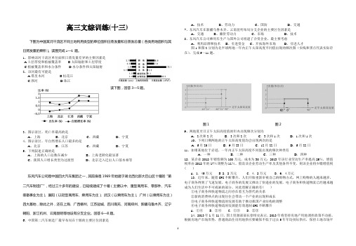
6、中国第二汽车制造厂最早布局在十堰的主要区位因素是A、技术B、劳动力C、国防D、交通7、东风汽车在新疆乌鲁木齐、云南昆明布局分支企业的主要区位因素是A、交通B、廉价劳动力C、市场D、技术8、东风汽车公司乘用车生产与国外公司组建了合资企业,最主要考虑A、利用品牌和技术B、引进资金C、开拓海外市场D、引进人才图1和图2分别为北半球两地一年内正午太阳高度不同值出现的频次图(实线和黑点代表实际存在),完成9~11题。
图1 图29、两地夏至日正午太阳高度值的年内出现频次分别为A.2次和2次B.3次和2次C.3次和1次D.1次和1次10、下列日期两地的正午太阳高度值均会出现两次的是A.6月20日B.9月23日C.12月22日D.6月22日11、如果某地位于赤道,一年内正午太阳高度不同值出现的频次种类有A.一种B.二种C.三种D.四种12.某企业2012年销售额为100万元,成本为30万元;2013年该行业劳动生产率提高25%,增值税率由2012年的17%调整为11%。
2016 中国坚持通过谈判解决中国与菲律宾在南海的有关争议 白皮书 中英对照
中国坚持通过谈判解决中国与菲律宾在南海的有关争议China Adheres to the Position of Settling Through Negotiation the Relevant Disputes Between China and the Philippines in the South China Sea(2016年7月)中华人民共和国国务院新闻办公室July 2016The State Council Information Officeof the People's Republic of China目录Contents引言Introduction一、南海诸岛是中国固有领土I. Nanhai Zhudao are China's Inherent Territory(一)中国对南海诸岛的主权是历史上确立的i. China's sovereignty over Nanhai Zhudao is established in the course of history(二)中国始终坚定维护在南海的领土主权和海洋权益ii. China has always been resolute in upholding its territorial sovereignty and maritime rights and interests in the South China Sea(三)中国对南海诸岛的主权得到国际社会广泛承认iii. China's sovereignty over Nanhai Zhudao is widely acknowledged in the international community二、中菲南海有关争议的由来II. Origin of the Relevant Disputes Between China and the Philippines in the South China Sea(一)菲律宾非法侵占行为制造了中菲南沙岛礁争议i. The Philippines' invasion and illegal occupation caused disputes with China over some islands and reefs of Nansha Qundao(二)菲律宾的非法主张毫无历史和法理依据ii. The Philippines' illegal claim has no historical or legal basis(三)国际海洋法制度的发展导致中菲出现海洋划界争议iii. The development of the international law of the sea gave rise to the dispute between China and the Philippines over maritime delimitation三、中菲已就解决南海有关争议达成共识III. China and the Philippines Have Reached Consensus on Settling Their Relevant Disputes in the South China Sea(一)通过谈判解决南海有关争议是中菲共识和承诺i. It is the consensus and commitment of China and the Philippines to settle through negotiation their relevant disputes in the South China Sea(二)妥善管控南海有关争议是中菲之间的共识ii. It is the consensus of China and the Philippines to properly manage relevant disputes in the South China Sea四、菲律宾一再采取导致争议复杂化的行动IV. The Philippines Has Repeatedly Taken Moves that Complicate the Relevant Disputes(一)菲律宾企图扩大对中国南沙群岛部分岛礁的侵占i. The Philippines attempts to entrench its illegal occupation of some islands and reefs of China's Nansha Qundao(二)菲律宾一再扩大海上侵权ii. The Philippines has increasingly intensified its infringement of China's maritime rights and interests(三)菲律宾企图染指中国黄岩岛iii. The Philippines also has territorial pretensions on China's Huangyan Dao(四)菲律宾单方面提起仲裁是恶意行为iv. The Philippines' unilateral initiation of arbitration is an act of bad faith五、中国处理南海问题的政策V. China's Policy on the South China Sea Issue(一)关于南沙群岛领土问题i. On the territorial issues concerning Nansha Qundao(二)关于南海海洋划界问题ii. On maritime delimitation in the South China Sea(三)关于争端解决方式iii. On the ways and means of dispute settlement(四)关于在南海管控分歧和开展海上务实合作iv. On managing differences and engaging in practical maritime cooperation in the South China Sea(五)关于南海航行自由和安全v. On freedom and safety of navigation in the South China Sea(六)关于共同维护南海和平稳定vi. On jointly upholding peace and stability in the South China Sea引言Introduction1. 南海位于中国大陆的南面,通过狭窄的海峡或水道,东与太平洋相连,西与印度洋相通,是一个东北-西南走向的半闭海。
《钓鱼岛是中国的固有领土》白皮书的举证研究
《钓鱼岛是中国的固有领土》白皮书的举证研究孙自挥;黄亚宁【摘要】中国政府《钓鱼岛是中国的固有领土》白皮书从历史、地理、法理的角度,举证证明钓鱼岛及其附属岛屿自古以来就是中国的固有领土。
本文通过对该白皮书中举证手段的聚焦研究,解读白皮书中举证的多重作用和意义。
%The white paper,Diaoyu Dao,an Inherent Territory of China focuses on interpreting the evidential role of the archive documents from history,geography and international law related with Diaoyu Dao,and fully proves the un-questionable right of Chinaˊs sovereignty over the islands. Though the focus research on the evidential means of this white paper,this paper interprets its multiple roles and significance in evidence.【期刊名称】《成都师范学院学报》【年(卷),期】2014(000)010【总页数】4页(P1-4)【关键词】举证;钓鱼岛;白皮书【作者】孙自挥;黄亚宁【作者单位】成都师范学院外语系;成都师范学院宣传统战部,成都 611130【正文语种】中文【中图分类】D8312012年9月,中华人民共和国国务院新闻办公室向全世界发布了《钓鱼岛是中国的固有领土》白皮书。
白皮书是一种国家对外话语,为了使其提供的信息为受众所接受,白皮书必然要对所提供信息的证据来源及其可靠程度加以说明,因为信息的认可离不开证据的支持,它们是确保白皮书客观公正、令人信服的资源保障。
翻译硕士真题3月28日
【1】2013年南开大学MTI翻译硕士真题(回忆版)【翻译硕士英语】作文:What Can We Do with a Smartphone?【英语翻译基础】一、英汉互译RCEP,Royal Commission on Environmental Pollution 皇家环境污染委员会a bull market,牛市,价格上涨的市场Russian ruble,俄罗斯卢布anti-dumping,反倾销stock in trade,库存, 存货paid on delivery,货到付款unanimous vote,全票通过carbon footprint,碳足迹recursive function,递归函数provisional agenda,临时议程ready-made garment,成衣United Nation secretariat,联合国秘书处Global Environment Facility,全球环境基金International Refugee Organization,国际难民组织The World Travel and Tourism Council,世界旅行和旅游理事会种族歧视,race discrimination就职演说,inaugural speech和谐共赢,harmonious and win-win文化事业,cultural undertakings全民健身,nationwide fitness programs本地化服务,localization services产能过剩行业,industries with excess capacity放宽市场准入,liberalize market access自主创新能力,capacity for independent innovation载人航天飞行,manned space flight促进生态修复,promote ecological restoration公共卫生体系,public health system科技成果产业化,industrialization of scientific and technological achievements多语言跨文化交际,multi-language cross- cultural communication古为今用,洋为中用make the past serve the present, to make foreign things serve China二、英译汉:As long as there is class division and social inequality, Karl Marx will be the most relevant social thinker of the twenty-one century.……三、汉译英:科学家们花了300年的时间,通过做实验并进行计算,才确定了光在真空中惊人的传播速度:每秒钟186,282英里(约折合299,784公里)。
史籍《顺风相送》有力佐证钓鱼岛是中国固有领土
史籍《顺风相送》有力佐证钓鱼岛是中国固有领土(学习版)编制人:__________________审核人:__________________审批人:__________________编制学校:__________________编制时间:____年____月____日序言下载提示:该文档是本店铺精心编制而成的,希望大家下载后,能够帮助大家解决实际问题。
文档下载后可定制修改,请根据实际需要进行调整和使用,谢谢!并且,本店铺为大家提供各种类型的学习资料,如英语资料、语文资料、数学资料、物理资料、化学资料、生物资料、地理资料、历史资料、政治资料、其他资料等等,想了解不同资料格式和写法,敬请关注!Download tips: This document is carefully compiled by this editor.I hope that after you download it, it can help you solve practical problems. The document can be customized and modified after downloading, please adjust and use it according to actual needs, thank you!In addition, this shop provides various types of learning materials for everyone, such as English materials, language materials, mathematics materials, physical materials, chemical materials, biological materials, geographic materials, historical materials, political materials, other materials, etc. Please pay attention to the data format and writing method!史籍《顺风相送》有力佐证钓鱼岛是中国固有领土--> 【文化走出去·伦敦书展系列】钓鱼岛是中国固有领土,这是不争的事实。
- 1、下载文档前请自行甄别文档内容的完整性,平台不提供额外的编辑、内容补充、找答案等附加服务。
- 2、"仅部分预览"的文档,不可在线预览部分如存在完整性等问题,可反馈申请退款(可完整预览的文档不适用该条件!)。
- 3、如文档侵犯您的权益,请联系客服反馈,我们会尽快为您处理(人工客服工作时间:9:00-18:30)。
Full Text: Diaoyu Dao, an Inherent Territory of ChinaBEIJING, Sept. 25 (Xinhua) -- The State Council Information Office of the People's Republic of China on Tuesday published a white paper on Diaoyu Dao, an inherent territory of China. Following is the full text of the white paper:Diaoyu Dao, an Inherent Territory of China(September 2012)State Council Information OfficeThe People's Republic of ChinaContentsForewordI. Diaoyu Dao is China's Inherent TerritoryII. Japan Grabbed Diaoyu Dao from ChinaIII. Backroom Deals Between the United States and Japan Concerning Diaoyu Dao are Illegal and InvalidIV. Japan's Claim of Sovereignty over Diaoyu Dao is Totally UnfoundedV. China has Taken Resolute Measures to Safeguard its Sovereignty over Diaoyu Dao ConclusionForewordDiaoyu Dao and its affiliated islands are an inseparable part of the Chinese territory. Diaoyu Dao is China's inherent territory in all historical, geographical and legal terms, and China enjoys indisputable sovereignty over Diaoyu Dao.Japan's occupation of Diaoyu Dao during the Sino-Japanese War in 1895 is illegal and invalid. After World War II, Diaoyu Dao was returned to China in accordance with such international legal documents as the Cairo Declaration and the Potsdam Proclamation. No matter what unilateral step Japan takes over Diaoyu Dao, it will not change the fact that Diaoyu Dao belongs to China. For quite some time, Japan has repeatedly stirred up troubles on the issue of Diaoyu Dao. On September 10, 2012, the Japanese government announced the "purchase" of Diaoyu Dao and its affiliated Nanxiao Dao and Beixiao Dao and the implementation of the so-called "nationalization". This is a move that grossly violates China's territorial sovereignty and seriously tramples on historical facts and international jurisprudence.China is firmly opposed to Japan's violation of China's sovereignty over Diaoyu Dao in whatever form and has taken resolute measures to curb any such act. China's position on the issue of Diaoyu Dao is clear-cut and consistent. China's will to defend national sovereignty and territorial integrity is firm and its resolve to uphold the outcomes of the World Anti-Fascist War will not be shaken by any force.I. Diaoyu Dao is China's Inherent TerritoryDiaoyu Dao and its affiliated islands, which consist of Diaoyu Dao, Huangwei Yu, Chiwei Yu, Nanxiao Dao, Beixiao Dao, Nan Yu, Bei Yu, Fei Yu and other islands and reefs, are located to the northeast of China's Taiwan Island, in the waters between 123º20'-124º40'E (East Longitude) and 25º40'-26º00'N (North Latitude), and are affiliated to the Taiwan Island. The total landmass ofthese islands is approximately 5.69 square kilometers. Diaoyu Dao, situated in the western tip of the area, covers a landmass of about 3.91 square kilometers and is the largest island in the area. The highest peak on the island stands 362 meters above the sea level. Huangwei Yu, which is located about 27 kilometers to the northeast of Diaoyu Dao, is the second largest island in the area, with a total landmass of about 0.91 square kilometers and a highest elevation of 117 meters. Chiwei Yu, situated about 110 kilometers to the northeast of Diaoyu Dao, is the easternmost island in the area. It covers a landmass of approximately 0.065 square kilometers and stands 75 meters above the sea level at its peak.1. Diaoyu Dao was first discovered, named and exploited by ChinaAncient ancestors in China first discovered and named Diaoyu Dao through their production and fishery activities on the sea. In China's historical literatures, Diaoyu Dao is also called Diaoyu Yu or Diaoyu Tai. The earliest historical record of the names of Diaoyu Dao, Chiwei Yu and other places can be found in the book Voyage with a Tail Wind (Shun Feng Xiang Song) published in 1403 (the first year of the reign of Emperor Yongle of the Ming Dynasty). It shows that China had already discovered and named Diaoyu Dao by the 14th and 15th centuries.P In 1372 (the fifth year of the reign of Emperor Hongwu of the Ming Dynasty), the King of Ryukyu started paying tribute to the imperial court of the Ming Dynasty. In return, Emperor Hongwu (the first emperor of the Ming Dynasty) sent imperial envoys to Ryukyu. In the following five centuries until 1866 (the fifth year of the reign of Emperor Tongzhi of the Qing Dynasty), the imperial courts of the Ming and Qing Dynasties sent imperial envoys to Ryukyu 24 times to confer titles on the Ryukyu King, and Diaoyu Dao was exactly located on their route to Ryukyu. Ample volume of records about Diaoyu Dao could be found in the reports written by Chinese imperial envoys at the time. For example, the Records of the Imperial Title-conferring Envoys to Ryukyu (Shi Liu Qiu Lu) written in 1534 by Chen Kan, an imperial title-conferring envoy from the Ming court, clearly stated that "the ship has passed Diaoyu Dao, Huangmao Yu, Chi Yu... Then Gumi Mountain comes into sight, that is where the land of Ryukyu begins." The Shi Liu Qiu Lu of another imperial envoy of the Ming Dynasty, Guo Rulin, in 1562 also stated that "Chi Yu is the mountain that marks the boundary of Ryukyu". In 1719, Xu Baoguang, a deputy title-conferring envoy to Ryukyu in the Qing Dynasty, clearly recorded in his book Records of Messages from Chong-shan (Zhong Shan Chuan Xin Lu) that the voyage from Fujian to Ryukyu passed Huaping Yu, Pengjia Yu, Diaoyu Dao, Huangwei Yu, Chiwei Yu and reached Naba (Naha) port of Ryukyu via Gumi Mountain (the mountain guarding the southwest border of Ryukyu) and Machi Island.In 1650, the Annals of Chong-shan (Zhong Shan Shi Jian), the first official historical record of the Ryukyu Kingdom drafted under the supervision of Ryukyu's prime minister Xiang Xiangxian (Kozoken), confirmed that Gumi Mountain (also called Gumi Mountain, known as Kume Island today) is part of Ryukyu's territory, while Chi Yu (known as Chiwei Yu today) and the areas to its west are not Ryukyu's territory. In 1708, Cheng Shunze (Tei Junsoku), a noted scholar and the Grand Master with the Purple-Golden Ribbon (Zi Jin Da Fu) of Ryukyu, recorded in his book A General Guide (Zhi Nan Guang Yi) that "Gumi Mountain is the mountain guarding the southwest border of Ryukyu".These historical accounts clearly demonstrate that Diaoyu Dao and Chiwei Yu belong to China and Kume Island belongs to Ryukyu, and that the separating line lies in Hei Shui Gou (today's Okinawa Trough) between Chiwei Yu and Kume Island. In 1579, Xie Jie, a deputy imperial title-conferring envoy of the Ming Dynasty, recorded in his book, Addendum to Summarized Record of Ryukyu (LiuQiu Lu Cuo Yao Bu Yi) that he entered Ryukyu from Cang Shui to Hei Shui, and returned to China from Hei Shui to Cang Shui. Xia Ziyang, another imperial envoy of the Ming court, wrote in 1606 that "when the water flows from Hei Shui back to Cang Shui, it enters the Chinese territory." Miscellaneous Records of a Mission to Ryukyu (Shi Liu Qiu Za Lu), a book written in 1683 by Wang Ji, an imperial envoy of the Qing Dynasty, stated that "Hei Shui Gou", situated outside Chi Yu, is the "boundary between China and foreign land". In 1756, Zhou Huang, a deputy imperial envoy of the Qing Dynasty, recorded in his book, the Annals of Ryukyu (Liu Qiu Guo Zhi Lue), that Ryukyu "is separated from the waters of Fujian by Hei Shui Gou to the west".The waters surrounding Diaoyu Dao are traditionally Chinese fishing ground. Chinese fishermen have, for generations, engaged in fishery activities in these waters. In the past, Diaoyu Dao was used as a navigation marker by the Chinese people living on the southeast coast.2. Diaoyu Dao had long been under China's jurisdictionIn the early years of the Ming Dynasty, China placed Diaoyu Dao under its coastal defense to guard against the invasion of Japanese pirates along its southeast coast. In 1561 (the 40th year of the reign of Emperor Jiajing of the Ming Dynasty), An Illustrated Compendium on Maritime Security (Chou Hai Tu Bian) compiled by Zheng Ruozeng under the auspices of Hu Zongxian, the supreme commander of the southeast coastal defense of the Ming court, included the Diaoyu Dao Islands on the "Map of Coastal Mountains and Sands" (Yan Hai Shan Sha Tu) and incorporated them into the jurisdiction of the coastal defense of the Ming court. The Complete Map of Unified Maritime Territory for Coastal Defense (Qian Kun Yi Tong Hai Fang Quan Tu), drawn up by Xu Bida and others in 1605 (the 33rd year of the reign of Emperor Wanli of the Ming Dynasty) and the Treatise on Military Preparations.Coastal Defense II.Map of Fujian's Coastal Mountains and Sands (Wu Bei Zhi.Hai Fang Er.Fu Jian Yan Hai Shan Sha Tu), drawn up by Mao Yuanyi in 1621 (the first year of the reign of Emperor Tianqi of the Ming Dynasty), also included the Diaoyu Dao Islands as part of China's maritime territory.The Qing court not only incorporated the Diaoyu Dao Islands into the scope of China's coastal defense as the Ming court did, but also clearly placed the islands under the jurisdiction of the local government of Taiwan. Official documents of the Qing court, such as A Tour of Duty in the Taiwan Strait (Tai Hai Shi Cha Lu) and Annals of Taiwan Prefecture (Tai Wan Fu Zhi) all gave detailed accounts concerning China's administration over Diaoyu Dao. Volume 86 of Recompiled General Annals of Fujian (Chong Zuan Fu Jian Tong Zhi), a book compiled by Chen Shouqi and others in 1871 (the tenth year of the reign of Emperor Tongzhi of the Qing Dynasty), included Diaoyu Dao as a strategic location for coastal defense and placed the islands under the jurisdiction of Gamalan, Taiwan (known as Yilan County today).3. Chinese and foreign maps show that Diaoyu Dao belongs to ChinaThe Roadmap to Ryukyu (Liu Qiu Guo Hai Tu) in the Shi Liu Qiu Lu written by imperialtitle-conferring envoy Xiao Chongye in 1579 (the seventh year of the reign of Emperor Wanli of the Ming Dynasty), the Record of the Interpreters of August Ming (Huang Ming Xiang Xu Lu) written by Mao Ruizheng in 1629 (the second year of the reign of Emperor Chongzhen of the Ming Dynasty), the Great Universal Geographic Map (Kun Yu Quan Tu) created in 1767 (the 32nd year of the reign of Emperor Qianlong of the Qing Dynasty), and the Atlas of the Great Qing Dynasty (Huang Chao Zhong Wai Yi Tong Yu Tu) published in 1863 (the second year of the reign of Emperor Tongzhi of the Qing Dynasty) all marked Diaoyu Dao as China's territory.The book Illustrated Outline of the Three Countries written by Hayashi Shihei in 1785 was the earliest Japanese literature to mention Diaoyu Dao. The Map of the Three Provinces and 36 Islands of Ryukyu in the book put Diaoyu Dao as being apart from the 36 islands of Ryukyu and colored it the same as the mainland of China, indicating that Diaoyu Dao was part of China's territory. The Map of East China Sea Littoral States created by the French cartographer Pierre Lapie and others in 1809 colored Diaoyu Dao, Huangwei Yu, Chiwei Yu and the Taiwan Island as the same. Maps such as A New Map of China from the Latest Authorities published in Britain in 1811, Colton's China published in the United States in 1859, and A Map of China's East Coast: Hongkong to Gulf of Liao-Tung compiled by the British Navy in 1877 all marked Diaoyu Dao as part of China's territory.II. Japan Grabbed Diaoyu Dao from ChinaJapan accelerated its invasion and external expansion after the Meiji Restoration. Japan seized Ryukyu in 1879 and changed its name to Okinawa Prefecture. Soon after that, Japan began to act covertly to invade and occupy Diaoyu Dao and secretly "included" Diaoyu Dao in its territory at the end of the Sino-Japanese War of 1894-1895. Japan then forced China to sign the unequal Treaty of Shimonoseki and cede to Japan the island of Formosa (Taiwan), together with Diaoyu Dao and all other islands appertaining or belonging to the said island of Formosa.1. Japan's covert moves to seize Diaoyu DaoIn 1884, a Japanese man claimed that he first landed on Diaoyu Dao and found the island to be uninhabited. The Japanese government then dispatched secret facts-finding missions to Diaoyu Dao and attempted to invade and occupy the island. The above-mentioned plots by Japan triggered China's alert. On September 6, 1885 (the 28th day of the 7th month in the 11th year of the reign of Emperor Guangxu of the Qing Dynasty), the Chinese newspaper Shen-pao (Shanghai News) reported: "Recently, Japanese flags have been seen on the islands northeast to Taiwan, revealing Japan's intention to occupy these islands." But the Japanese government did not dare to take any further action for fear of reaction from China.After the secret facts-finding missions to Diaoyu Dao, the governor of Okinawa Prefecture sent a report in secrecy to the Minister of Internal Affairs Yamagata Aritomo on September 22, 1885, saying that these uninhabited islands were, in fact, the same Diaoyu Tai, Huangwei Yu and Chiwe Yu that were recorded in the Records of Messages from Chong-shan (Zhong Shan Chuan Xin Lu) and known well to imperial title-conferring envoys of the Qing court on their voyages to Ryukyu, and that he had doubts as to whether or not sovereignty markers should be set up and therefore asked for instruction. The Minister of Internal Affairs Yamagata Aritomo solicited opinion from the Foreign Minister Inoue Kaoru on October 9. Inoue Kaoru replied in a letter to Yamagata Aritomo on October 21, "At present, any open moves such as placing sovereignty markers are bound to alert the Qing imperial court. Therefore, it is advisable not to go beyond field surveys and detailed reports on the shapes of the bays, land and other resources for future development. In the meantime, we will wait for a better time to engage in such activities as putting up sovereignty markers and embarking on development on the islands." Inoue Kaoru also made a special emphasis that "it is inappropriate to publicize the missions on official gazette or newspapers." As a result, the Japanese government did not approve of the request of Okinawa Prefecture to set up sovereignty markers.The governor of Okinawa Prefecture submitted the matter for approval to the Minister of Internal Affairs once again on January 13, 1890, saying that Diaoyu Dao and other "above-mentioned uninhabited islands have remained under no specific jurisdiction", and that he "intends to place them under the jurisdiction of the Office of Yaeyama Islands." On November 2, 1893, the governor of Okinawa Prefecture applied once again for setting up sovereignty markers to incorporate the islands into Japan's territory. The Japanese government did not respond. On May 12, 1894, two months before the Sino-Japanese War, the secret facts-finding missions to Diaoyu Dao by Okinawa Prefecture came to a final conclusion, "Ever since the prefecture police surveyed the island in 1885 (the 18th year of the Meiji period), there have been no subsequent investigations. As a result, it is difficult to provide any specific reports on it... In addition, there exist no old records related to the said island or folklore and legends demonstrating that the island belongs to our country."Japan's attempts to occupy Diaoyu Dao were clearly recorded in Japan Diplomatic Documents compiled by the Japanese Foreign Ministry. Relevant documents evidently show that the Japanese government intended to occupy Diaoyu Dao, but refrained from acting impetuously as it was fully aware of China's sovereignty over these islands.Japan waged the Sino-Japanese War in July 1894. Towards the end of November 1894, Japanese forces seized the Chinese port of Lushun (then known as Port Arthur), virtually securing defeat of the Qing court. Against such backdrop, the Japanese Minister of Internal Affairs Yasushi Nomura wrote to Foreign Minister Mutsu Munemitsu on December 27 that the "circumstances have now changed", and called for a decision by the cabinet on the issue of setting up sovereignty markers in Diaoyu Dao and incorporating the island into Japan's territory. Mutsu Munemitsu expressed his support for the proposal in his reply to Yasushi Nomura on January 11, 1895. The Japanese cabinet secretly passed a resolution on January 14 to "place" Diaoyu Dao under the jurisdiction of Okinawa Prefecture.Japan's official documents show that from the time of the facts-finding missions to Diaoyu Dao in 1885 to the occupation of the islands in 1895, Japan had consistently acted in secrecy without making its moves public. This further proves that Japan's claim of sovereignty over Diaoyu Dao does not have legal effect under international law.2. Diaoyu Dao was ceded to Japan together with the Taiwan IslandOn April 17, 1895, the Qing court was defeated in the Sino-Japanese War and forced to sign the unequal Treaty of Shimonoseki and cede to Japan "the island of Formosa (Taiwan), together with all islands appertaining or belonging to the said island of Formosa". The Diaoyu Dao Islands were ceded to Japan as "islands appertaining or belonging to the said island of Formosa". In 1900, Japan changed the name of Diaoyu Dao to "Senkaku Islands".III. Backroom Deals Between the United States and Japan Concerning Diaoyu Dao are Illegal and InvalidDiaoyu Dao was returned to China after the Second World War. However, the United States arbitrarily included Diaoyu Dao under its trusteeship in the 1950s and "returned" the "power of administration" over Diaoyu Dao to Japan in the 1970s. The backroom deals between the United States and Japan concerning Diaoyu Dao are acts of grave violation of China's territorial sovereignty. They are illegal and invalid. They have not and cannot change the fact that Diaoyu Dao belongs to China.1. Diaoyu Dao was returned to China after the Second World WarIn December 1941, the Chinese government officially declared war against Japan together with the abrogation of all treaties between China and Japan. In December 1943, the Cairo Declaration stated in explicit terms that "all the territories Japan has stolen from the Chinese, such as Manchuria, Formosa [Taiwan] and the Pescadores, shall be restored to the Republic of China. Japan will also be expelled from all other territories which she has taken by violence and greed." In July 1945, the Potsdam Proclamation stated in Article 8: "The terms of the Cairo Declaration shall be carried out and Japanese sovereignty shall be limited to the islands of Honshu, Hokkaido, Kyushu, Shikoku and such minor islands as we determine." On September 2, 1945, the Japanese government accepted the Potsdam Proclamation in explicit terms with the Japanese Instrument of Surrender and pledged to faithfully fulfill the obligations enshrined in the provisions of the Potsdam Proclamation. On January 29, 1946, the Supreme Commander for the Allied Powers Instruction (SCAPIN) No.677 clearly defined Japan's power of administration to "include the four main islands of Japan (Hokkaido, Honshu, Kyushu and Shikoku) and the approximately 1,000 smaller adjacent islands, including the Tsushima Islands and the Ryukyu Islands north of the 30th parallel of North Latitude". On October 25, 1945, the ceremony for accepting Japan's surrender in Taiwan Province of the China War Theater was held in Taipei, and the Chinese government officially recovered Taiwan. On September 29, 1972, the Japanese government committed with all seriousness in the China-Japan Joint Statement that "the Government of Japan fully understands and respects this stand of the Government of the People's Republic of China [Taiwan is an inalienable part of the territory of the People's Republic of China], and it firmly maintains its stand under Article 8 of the Potsdam Proclamation."These facts show that in accordance with the Cairo Declaration, the Potsdam Proclamation and the Japanese Instrument of Surrender, Diaoyu Dao, as affiliated islands of Taiwan, should be returned, together with Taiwan, to China.2. The United States illegally included Diaoyu Dao under its trusteeshipOn September 8, 1951, Japan, the United States and a number of other countries signed the Treaty of Peace with Japan (commonly known as the Treaty of San Francisco) with China being excluded from it. The treaty placed the Nansei Islands south of the 29th parallel of North Latitude under United Nations' trusteeship, with the United States as the sole administering authority. It should be pointed out that the Nansei Islands placed under the administration of the United States in the Treaty of Peace with Japan did not include Diaoyu Dao.The United States Civil Administration of the Ryukyu Islands (USCAR) issued Civil Administration Ordinance No. 68 (Provisions of the Government of the Ryukyu Islands) on February 29, 1952 and Civil Administration Proclamation No. 27 (defining the "geographical boundary lines of the Ryukyu Islands") on December 25, 1953, arbitrarily expanding its jurisdiction to include China's Diaoyu Dao. However, there were no legal grounds whatsoever for the US act, to which China has firmly opposed.3. The United States and Japan conducted backroom deals concerning the "power of administration" over Diaoyu DaoOn June 17, 1971, Japan and the United States signed the Agreement Concerning the Ryukyu Islands and the Daito Islands (Okinawa Reversion Agreement), which provided that any and all powers of administration over the Ryukyu Islands and Diaoyu Dao would be "returned" to Japan. The Chinese people, including overseas Chinese, all condemned such a backroom deal. On December 30, 1971, the Chinese Ministry of Foreign Affairs issued a solemn statement, pointingout that "it is completely illegal for the government of the United States and Japan to include China's Diaoyu Dao Islands into the territories to be returned to Japan in the Okinawa Reversion Agreement and that it can by no means change the People's Republic of China's territorial sovereignty over the Diaoyu Dao Islands". The Taiwan authorities also expressed firm opposition to the backroom deal between the United States and Japan.In response to the strong opposition of the Chinese government and people, the United States had to publicly clarify its position on the sovereignty over Diaoyu Dao. In October 1971, the US administration stated that "the United States believes that a return of administrative rights over those islands to Japan, from which the rights were received, can in no way prejudice any underlying claims. The United States cannot add to the legal rights Japan possessed before it transferred administration of the islands to us, nor can the United States, by giving back what it received, diminish the rights of other claimants... The United States has made no claim to Diaoyu Dao and considers that any conflicting claims to the islands are a matter for resolution by the parties concerned." In November 1971, when presenting the Okinawa Reversion Agreement to the US Senate for ratification, the US Department of State stressed that the United States took a neutral position with regard to the competing Japanese and Chinese claims to the islands, despite the return of administrative rights over the islands to Japan.IV. Japan's Claim of Sovereignty over Diaoyu Dao Is Totally UnfoundedOn March 8, 1972, Japan's Ministry of Foreign Affairs issued the Basic View on the Sovereignty over the Senkaku Islands in an attempt to explain the Japanese government's claims of sovereignty over Diaoyu Dao. First, Japan claims that Diaoyu Dao was "terra nullius" and not part of Pescadores, Formosa [Taiwan] or their affiliated islands which were ceded to Japan by the Qing government in accordance with the Treaty of Shimonoseki. Second, Japan claims that Diaoyu Dao was not included in the territory which Japan renounced under Article 2 of the Treaty of San Francisco, but was placed under the administration of the United States as part of the Nansei Islands in accordance with Article 3 of the said treaty, and was included in the area for which the administrative rights were reverted to Japan in accordance with the Okinawa Reversion Agreement. Third, Japan claims that China didn't regard Diaoyu Dao as part of Taiwan and had never challenged the inclusion of the islands in the area over which the United States exercised administrative rights in accordance with Article 3 of the Treaty of San Francisco.Such claims by Japan fly in the face of facts and are totally unfounded.Diaoyu Dao belongs to China. It is by no means "terra nullius". China is the indisputable owner of Diaoyu Dao as it had exercised valid jurisdiction over the island for several hundred years long before the Japanese people "discovered" it. As stated above, voluminous Japanese official documents prove that Japan was fully aware that according to international law, Diaoyu Dao has long been part of China and was not "terra nullius". Japan's act to include Diaoyu Dao as "terra nullius" into its territory based on the "occupation" principle is in fact an illegal act of occupying Chinese territory and has no legal effect according to international law.Diaoyu Dao has always been affiliated to China's Taiwan Island both in geographical terms and in accordance with China's historical jurisdiction practice. Through the unequal Treaty of Shimonoseki, Japan forced the Qing court to cede to it "the island of Taiwan, together with all islands appertaining or belonging to it", including Diaoyu Dao. International legal documents such as the Cairo Declaration and the Potsdam Proclamation provide that Japan must unconditionallyreturn the territories it has stolen from China. These documents also clearly define Japan's territory, which by no means includes Diaoyu Dao. Japan's attempted occupation of Diaoyu Dao, in essence, constitutes a challenge to the post-war international order established by such legal documents as the Cairo Declaration and the Potsdam Proclamation and seriously violates the obligations Japan should undertake according to international law.Diaoyu Dao was not placed under the trusteeship established by the Treaty of San Francisco, which was signed between the United States and other countries with Japan and is partial in nature. The United States arbitrarily expanded the scope of trusteeship to include Diaoyu Dao, which is China's territory, and later "returned" the "power of administration" over Diaoyu Dao to Japan. This has no legal basis and is totally invalid according to international law. The government and people of China have always explicitly opposed such illegal acts of the United States and Japan.V. China has Taken Resolute Measures to Safeguard its Sovereignty over Diaoyu Dao China has, over the past years, taken resolute measures to safeguard its sovereignty over Diaoyu Dao.China has, through the diplomatic channel, strongly protested against and condemned the backroom deals between the United States and Japan over Diaoyu Dao. On August 15, 1951, before the San Francisco Conference, the Chinese government made a statement: "If the People's Republic of China is excluded from the preparation, formulation and signing of the peace treaty with Japan, it will, no matter what its content and outcome are, be regarded as illegal and therefore invalid by the central people's government." On September 18, 1951, the Chinese government issued another statement stressing that the Treaty of San Francisco is illegal and invalid and can under no circumstances be recognized. In 1971, responding to the ratifications of the Okinawa Reversion Agreement by the US Congress and Japanese Diet, the Chinese Foreign Ministry issued a stern statement which pointed out that the Diaoyu Dao Islands have been an indivisible part of the Chinese territory since ancient times.In response to Japan's illegal violation of China's sovereignty over Diaoyu Dao, the Chinese government has taken active and forceful measures such as issuing diplomatic statements, making serious representations with Japan and submitting notes of protest to the United Nations, solemnly stating China's consistent proposition, principle and position, firmly upholding China's territorial sovereignty and maritime rights and interests, and earnestly protecting the safety of life and property of Chinese citizens.China has enacted domestic laws, which clearly provide that Diaoyu Dao belongs to China. In 1958, the Chinese government released a statement on the territorial sea, announcing that Taiwan and its adjacent islands belong to China. In light of Japan's repeated violations of China's sovereignty over Diaoyu Dao since the 1970s, China adopted the Law of the People's Republic of China on the Territorial Sea and the Contiguous Zone in 1992, which unequivocally prescribes that "Taiwan and the various affiliated islands including Diaoyu Dao" belong to China. The 2009 Law of the People's Republic of China on the Protection of Offshore Islands establishes the protection, development and management system of offshore islands and prescribes the determination and announcement of the names of offshore islands, on the basis of which China announced the standard names of Diaoyu Dao and some of its affiliated islands in March 2012. On September 10, 2012, the Chinese government issued a statement announcing the baselines of the territorial sea of Diaoyu Dao and its affiliated islands. On September 13, the Chinese government deposited the coordinates table。