gis题
gis期末试题及答案
gis期末试题及答案一、选择题1. GIS的英文全称是什么?A. Geographic Information SystemB. Geographic Information ScienceC. Geographic Integrated SystemD. Geography Information Service答案:A2. GIS的基本功能包括地图生成、空间分析、数据管理等,以下哪项不属于GIS的基本功能?A. 数据挖掘B. 空间查询C. 编辑与更新D. 地图可视化答案:A3. GIS常用的数据类型主要包括矢量数据和栅格数据,下面哪项不是矢量数据?A. 点B. 线C. 图像D. 多边形答案:C4. GIS空间分析中的叠加分析是指什么?A. 将不同图层的要素叠加在一起进行分析B. 将二维数据转换为三维数据进行分析C. 将空间数据转换为属性数据进行分析D. 将两个GIS软件进行连接进行分析答案:A5. WebGIS是指什么?A. 利用GIS技术进行网页地图显示和空间分析的系统B. 在网络上进行GIS软件的在线购买和下载C. GIS软件的一种新型界面设计模式D. 利用网格计算方法进行GIS数据处理的系统答案:A二、简答题1. 请简要解释什么是GIS。
答案:GIS是地理信息系统的缩写,它是将地理空间数据与属性数据相结合,利用计算机技术进行地理数据的采集、处理、存储、分析和展示的系统。
通过GIS,我们可以进行地图生成、空间分析、数据管理等操作,帮助我们更好地理解和利用地理信息。
2. 请说明矢量数据和栅格数据的区别。
答案:矢量数据是用点、线、面等几何对象来表示地理现象的数据模型,它是由离散的点、线或面构成的,具有较高的精度和几何表达能力。
而栅格数据是将地理现象分割成均匀的网格单元,并用像元值来表示,它是由像元构成的,具有较高的数据表达能力和数据存储效率。
矢量数据适合表示具有明确边界和几何特征的地理现象,如建筑物、道路等;而栅格数据适合表示具有连续变化和空间分布特征的地理现象,如地形、降雨量等。
GIS考试试题汇编

GIS考试试题汇编一、简答题1. 什么是GIS?2. GIS的基本组成部分有哪些?3. 请简要描述地理数据模型的概念。
4. 请解释GIS中的空间数据和属性数据是如何相互关联的。
5. 请简述GIS的应用领域。
二、选择题1. 下列哪个不属于GIS的基本功能?- A. 数据采集- B. 数据存储- C. 数据分析- D. 数据销毁2. GIS最常用的数据类型是:- A. 栅格数据- B. 矢量数据- C. 属性数据- D. 拓扑数据3. 下列哪个软件不属于常见的GIS软件?- A. ArcGIS- B. QGIS- C. AutoCAD- D. MapInfo4. 属性查询是GIS中常用的操作之一,下列哪个查询条件是错误的?- A. 属性值等于某个特定值- B. 属性值大于某个特定值- C. 属性值不等于某个特定值- D. 属性值包含某个特定字符5. 下列哪个不是GIS数据采集的常用方法?- A. GPS定位- B. 遥感影像解译- C. 人工绘制- D. 数据挖掘三、解答题1. 请简要描述GIS在城市规划中的应用。
2. 简述GIS在环境保护领域的应用,并举例说明。
3. 请解释GIS数据质量评估的概念,并列举几种常见的数据质量问题。
四、案例分析请以某个实际案例为基础,结合GIS理论知识,进行案例分析并回答以下问题:1. 该案例中使用了哪些GIS数据类型?2. 通过GIS分析,该案例得出了哪些结论?3. 你认为该案例中还可以使用哪些其他的GIS功能来进一步分析和解决问题?以上是GIS考试试题汇编,祝您顺利通过考试!。
(完整版)GIS试题及答案
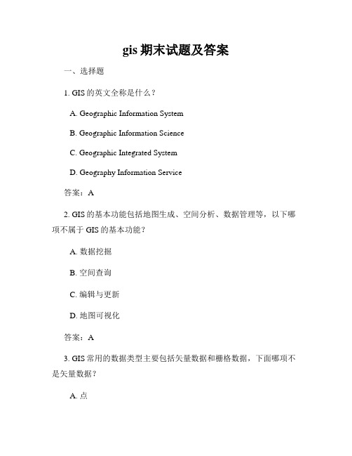
4.根据下面示意图,给出其的矢量数据结构编码。
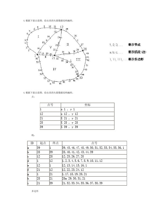
4.根据下面示意图,给出其的矢量数据结构编码。
点:点号坐标1 x 1 , y 112 x 12 , y 1221 X 21 , y 2128 X 28 , y 2839 X 39 , y 39线:ID 起点终点点号a 39 1 39,45,46,47,48,49,50,51,52,53,54,55,56,1b 28 39 28,40,41,42,43,44,39c 12 28 12,25,26,27,28d 1 12 1,2,3,4,5,6,7,8,9,10,11,12e 12 1 12,13,14,15,16,1f 21 12 12,22,23,24,12g 1 21 1,17,18,19,20,21h 28 21 28m 29,30,31,21i 21 39 21,32,33,34,35,36,37,38,39多边形多边形编号多边形边界I d, eII c, f, hIII b, h, iIV a, i, g模拟试题二4.下面两个多边形图层 A 和 B,图中标注的是多边形的属性,请画出 A 与 B 两个图层 Overlay 的结果图层 C 的示意图,并标注属性,其中 C 的属性为 C=A+B 。
“地理信息系统原理”课程考试试题一参考答案一、名词解释1.地理信息系统的定义是由两个部分组成的。
一方面,地理信息系统是一门学科,是描述、存储、分析和输出空间信息的理论和方法的一门新兴的交叉学科;另一方面,地理信息系统是一个技术系统,是以地理空间数据库为基础,采用地理模型分析方法,适时提供多种空间的和动态的地理信息,为地理研究和地理决策服务的计算机技术系统。
2.TIN 即不规则三角网(Triangulated Irregular Network),是一种表示数字高程模型的方法。
TIN 模型根据区域有限个点集将区域划分为相连的三角面网络,区域中任意点落在三角面的顶点、边上或三角形内。
地理信息系统考核题库
地理信息系统考核题库一、选择题1. GIS 是什么的缩写?A. Global Information SystemB. Geographic Information SystemC. Graphic Information SystemD. Geological Information System2. GIS 最常用的数据类型是什么?A. 空间数据B. 文字数据C. 图像数据D. 人口数据3. 下列哪个不是 GIS 的应用领域?A. 城市规划B. 气候预测C. 农业管理D. 医疗保健4. 以下哪个软件不是常用的 GIS 软件?A. ArcGISB. QGISC. AutoCADD. Google Earth5. GIS 技术主要用于什么方面的空间分析?A. 地形分析B. 人口分析C. 水资源分析D. 土地利用分析二、判断题1. GIS 只能用于地理相关的研究和应用。
A. 对B. 错2. GIS 数据可以包括地理位置和属性信息。
A. 对B. 错3. ArcGIS 是一款开源的 GIS 软件。
A. 对B. 错4. 矢量数据是以像素为单位来表示地理现象的。
A. 对B. 错5. 空间分析是 GIS 技术的重要应用之一。
A. 对B. 错三、简答题1. 请简要解释什么是坐标系统?2. 举例说明一种常用的坐标系统。
3. 请解释什么是空间查询?4. 请解释什么是地理编码?5. 请简要解释什么是地图投影?四、应用题1. 请设计一个城市公交系统的 GIS 应用方案,包括数据采集、数据分析和结果展示等方面。
2. 请说明使用 GIS 技术进行农业管理的优势,并列举至少两个具体应用案例。
3. 请说明使用 GIS 技术进行环境监测的优势,并列举至少两个具体应用案例。
4. 请设计一个基于 GIS 技术的旅游景点推荐系统,该系统可以根据用户的位置和偏好推荐附近的景点。
5. 请说明使用 GIS 技术进行城市规划的优势,并列举至少两个具体应用案例。
地理信息系统考核题库
地理信息系统考核题库一、选择题1. GIS是什么的缩写?- A. Global Information System- B. Geographic Information System- C. General Information System- D. Governmental Information System答案:B2. GIS主要用于什么领域?- A. 医学- B. 环境保护- C. 娱乐- D. 农业答案:B3. GIS中的地理数据主要包括哪些类型?- A. 数字地图- B. 遥感影像- C. 土地利用数据- D. 所有选项都对答案:D4. GIS中的空间分析是指什么?- A. 对地理数据进行可视化展示- B. 对地理数据进行统计分析- C. 对地理数据进行地形分析- D. 对地理数据进行空间关系的计算和处理答案:D5. GIS中常用的数据存储格式是什么?- A. JPEG- B. TXT- C. CSV- D. Shapefile答案:D二、判断题1. GIS只能处理地理数据,不能处理其他类型的数据。
- 正确- 错误答案:错误2. GIS的应用范围仅限于科学研究领域。
- 正确- 错误答案:错误3. 使用GIS可以进行地理数据的可视化展示。
- 正确- 错误答案:正确4. GIS的空间分析功能可以帮助决策者做出更科学的决策。
- 正确- 错误答案:正确5. GIS数据存储格式的选择对数据分析结果没有任何影响。
- 正确- 错误答案:错误三、简答题1. 请简要介绍一下地理信息系统(GIS)的基本原理和应用领域。
答案:地理信息系统(GIS)是一种用于存储、管理、分析和展示地理数据的系统。
其基本原理包括地理数据的采集、存储、处理和分析。
GIS的应用领域包括城市规划、环境保护、土地利用、农业、气候研究等。
2. 请简述GIS在城市规划中的应用。
答案:GIS在城市规划中可以用于地块分析、交通规划、设施分布等方面。
GIS地理信息考试问题集

GIS地理信息考试问题集问题1:什么是GIS地理信息系统?回答1:GIS地理信息系统是一种将地理空间数据与属性数据相结合的技术,用于收集、存储、管理、分析和展示地理信息的系统。
问题2:GIS地理信息系统有哪些应用领域?回答2:GIS地理信息系统广泛应用于城市规划、环境保护、土地管理、交通规划、资源调查、灾害管理等领域。
问题3:GIS地理信息系统主要包括哪些组成部分?回答3:GIS地理信息系统主要包括硬件、软件、数据和人员四个组成部分。
问题4:GIS地理信息系统中的数据类型有哪些?回答4:GIS地理信息系统中的数据类型包括地理空间数据和属性数据两种类型。
问题5:请举例说明GIS地理信息系统在实际应用中的作用。
回答5:例如,在城市规划中,GIS可以分析人口分布、交通状况、土地利用等数据,帮助规划者做出科学决策,提高城市规划的效率和质量。
问题6:GIS地理信息系统有哪些数据获取方式?回答6:GIS地理信息系统的数据获取方式包括现场采集、遥感获取、地图扫描和数据库导入等方式。
问题7:GIS地理信息系统的数据存储方式有哪些?回答7:GIS地理信息系统的数据存储方式包括文件存储、数据库存储和云存储等方式。
问题8:GIS地理信息系统的数据分析方法有哪些?回答8:GIS地理信息系统的数据分析方法包括空间分析、属性分析、网络分析、地形分析等方法。
问题9:GIS地理信息系统的数据可视化方式有哪些?回答9:GIS地理信息系统的数据可视化方式包括地图制作、图表生成、动态展示等方式。
问题10:GIS地理信息系统的发展趋势是什么?回答10:GIS地理信息系统的发展趋势是向大数据、云计算、移动化和智能化方向发展,提供更高效、更精准的地理信息服务。
地理信息系统考试试题
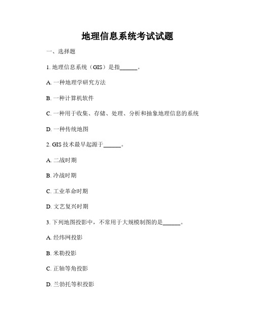
地理信息系统考试试题一、选择题1. 地理信息系统(GIS)是指______。
A. 一种地理学研究方法B. 一种计算机软件C. 一种用于收集、存储、处理、分析和抽象地理信息的系统D. 一种传统地图2. GIS技术最早起源于______。
A. 二战时期B. 冷战时期C. 工业革命时期D. 文艺复兴时期3. 下列地图投影中,不常用于大规模制图的是______。
A. 经纬网投影B. 米勒投影C. 正轴等角投影D. 兰勃托等积投影4. GIS数据模型包括______。
A. 点线面数据模型B. 网格数据模型C. 地理关系数据模型D. 以上都是5. 下列软件中,不属于专业的GIS软件是______。
A. ArcGISB. AutoCADC. QGISD. ERDAS二、填空题6. GIS中的底图通常采用______格式储存。
7. 矢量数据中的最小要素是______。
8. ______是用来代表地理空间要素的重要属性之间的关系的数据模型。
9. 颜色模式中,RGB代表______。
10. ______是GIS中的数据输入设备之一。
三、简答题11. 什么是地理信息系统?简述其发展历程。
12. GIS数据的分类及特点有哪些?13. 什么是地理数据模型?简述常见的地理数据模型。
14. 什么是地图投影?简要介绍常见的地图投影类型及其应用领域。
15. 请简述遥感影像在GIS中的应用。
四、计算题16. 若已知地图比例尺为1:50000,实地距离为2500米,求地图距离。
17. 设有一GIS数据集包括10个建筑物矢量要素,每个建筑物的属性数据包括建筑物类型、建筑面积和建筑年代等,求该数据集的记录数。
五、应用题18. 某市规划了一处公园,其周围分布有道路、湖泊和建筑物等要素。
请利用GIS软件绘制公园的周边环境地图,并进行空间分析,提出合理的规划建议。
以上为地理信息系统考试试题,请按要求完成答题。
地理信息系统考试问题集

地理信息系统考试问题集问题一:什么是地理信息系统(GIS)?地理信息系统(GIS)是一种将地理空间数据与属性数据相结合,进行存储、管理、分析和展示的计算机系统。
它可以帮助我们理解地理现象、探索空间关系和做出空间决策。
问题二:GIS的主要组成部分有哪些?GIS主要由硬件、软件、数据和人员组成。
硬件包括计算机、服务器、传感器等;软件包括GIS软件和相关的数据处理工具;数据包括地理空间数据和属性数据;人员包括GIS专业人员和使用者。
问题三:地理空间数据有哪些类型?地理空间数据可以分为两种类型:矢量数据和栅格数据。
矢量数据使用点、线、面等几何要素来表示地理对象;栅格数据则将地理空间划分为像素网格,每个像素包含一个值或属性。
问题四:地理信息系统有哪些应用领域?地理信息系统广泛应用于城市规划、环境保护、土地利用、交通管理、资源调查等领域。
它可以帮助政府、企业和个人进行空间分析、决策支持和资源管理。
问题五:地理信息系统的优势是什么?地理信息系统具有以下优势:- 可视化:可以通过地图等可视化方式展示地理数据,更直观地理解地理现象和空间关系。
- 空间分析:可以进行空间分析,揭示地理现象之间的关联和规律。
- 决策支持:可以提供空间数据和分析结果,帮助决策者做出合理的空间决策。
- 效率提升:可以集成和管理各种数据,提高数据处理和查询的效率。
问题六:如何获取地理空间数据?地理空间数据可以从多个渠道获取,包括:- 卫星遥感:通过卫星图像获取地理空间数据。
- 空中摄影:通过航空摄影获取地理空间数据。
- 地面调查:通过野外调查和测量获取地理空间数据。
- 数据共享:从政府机构、研究机构等获取已有的地理空间数据。
问题七:地理信息系统的未来发展趋势是什么?地理信息系统的未来发展趋势包括以下几个方面:- 云计算:地理信息系统将逐渐向云计算平台迁移,实现数据共享和协同处理。
- 移动化:地理信息系统将更加注重移动终端的应用,实现随时随地的数据采集和分析。
- 1、下载文档前请自行甄别文档内容的完整性,平台不提供额外的编辑、内容补充、找答案等附加服务。
- 2、"仅部分预览"的文档,不可在线预览部分如存在完整性等问题,可反馈申请退款(可完整预览的文档不适用该条件!)。
- 3、如文档侵犯您的权益,请联系客服反馈,我们会尽快为您处理(人工客服工作时间:9:00-18:30)。
《地理信息系统》双语课程辅导题一、Define the following terms (total marks are 15, and 3 marks of everyone)1. Geographic Information SystemGIS is much more than a container of maps in digital form.A GIS is also a computerized tool for solving geographic problems,A GIS is a mechanized inventory of geographically distributed features and facilitiesA GIS is a tool for revealing what is otherwise invisible in geographic information A GIS is a tool for performing operations on geographic data that are too tedious or expensive or inaccurate if performed by hand2. Tobler's First Law of GeographyEverything is related to everything else, but near things are more related than distant things.3. Spatial autocorrelationis a term referring to the degree of relationship that exists between two or more spatial variables, such that when one changes, the other(s) also change. This change can either be in the same direction, which is a positive autocorrelation, or in the opposite direction, which is a negative autocorrelation.4. Data modelA data model is an essential ingredient of any operational GIS, and the heart of any GIS is the data model, which is a set of constructs for representing objects and processes in the digital environment of the computer.There is no single type of GIS data model that is best for all circumstances.5. MetadataData about data and usage aspects of it. This information will often include some of the following:What it is about? Where it is to be found? Who one needs to ask to get it? How much it costs? Who can access it? In what format it is available? What is the quality of the data for a specified purpose? What spatial location does it cover and over what time period? When and where the data were collected and by whom and what purposes the data have been used for, by whom and what related data sets are available? etc.Metadata are needed for:To enable the process of search and discovery over distributed archives;To assess the fitness of a dataset for a given use;To provide the information needed to handle the dataset effectively; and To provide useful information on the dataset’s contents.6. Spatial analysisSpatial analysis is analytical techniques associated with the study of locations of geographic phenomena together with their spatial dimensions and their associated attributes.Spatial analysis is useful for evaluating suitability, for estimating and predicting, and for interpreting and understanding the location and distribution of geographic features and phenomena.Spatial analysis can reveal things that might otherwise be invisible - it can make what is implicit or implicit.Spatial analysis is the crux of GIS, the means of adding value to geographic data, and of turning data into useful information.Effective spatial analysis requires an intelligent user, not just a powerful computer.Spatial analysis helps us in situations when our eyes might otherwise deceive us. Spatial analysis is a set of methods whose results are not invariant under changes in the locations of the objects being analyzed.Spatial analysis is a set of methods whose results change when the locations of the objects being analyzed change.7. ClassificationClassification is a method of generalisation. In the process of classification, an attempt is made to group data into classes according to some common characteristics thereby reducing the number of data elements. Classification tends to be based upon the attributes or characteristics of data rather than their geometry. In digital image processing, images are usually classified according to the spectral properties of the pixels composing the image. In spatial analysis, a map can be classified according to any attribute value, for example, soil types, population density, unemployment etc. The result of performing classification is a thematic derived map.8. BufferBuffer — returns a geometry that represents all the points whose distance from the geometry is less than or equal to a user-defined distance. Given a geometry and a buffer distance, the buffer operator returns a polygon that covers all points whose distance from the geometry is less than or equal to the buffer distance.9. DEMThe term DEM can refer to one of the following: 1. A digital representation of a continuous variable over a two- dimensional surface by a regular array of z values referenced to a common datum. Digital elevation models are typically used to represent terrain relief and frequently comprise a foundational layer in any archaeological GIS database. 2. An elevation database for elevation data by map sheet from the National Mapping Division of the U.S. Geological Survey (USGS).3. The format of the USGS digital elevation data sets (ESRI 1996)10. NetworkAn interconnected set of arcs or lines representing possible paths for the movement of resources from one location to another.A group of computers that are linked, and are able to share peripherals, software and data. The Internet is probably the most well known example of a computernetwork.A type of database structure. A network data model is based upon the idea of explicit links between related entities.二、Cloze( total marks are 20, and 1mark for each blank)1.Many roots of GIS come from principles of geography.2.Canada Geographic Information System is developed in 1963 by Roger Tomlinsonand colleagues for Canadian Land Inventory.3.Arclnfo was the first major commercial GIS software system. Designed forminicomputers and based on the vector and relational database data model, it set a new standard for the industry.ponents of a GIS includes: Computer hardware, GIS software, People, Data,Network, Procedures.5.Geographical data link place, time and attributes.6.Geographical attributes are classified as nominal, ordinal, interval andratio.7.GIS software systems deal with the three-tier architecture to a GIS: userinterfaces, tools, and data management.8.Types of GIS software includes: Desktop GIS, Professional GIS, Server / InternetGIS, Developer / Component GIS, Hand-held GIS, Others(Raster-based GIS, CAD-based GIS)9.Spatial autocorrelation is determined both by similarities in position, andby similarities in attributes.10.Raster data model uses an array of cells, or pixels, to represent real-worldobjects. Features are vector objects of type point, polyline, or polygon.11.To improve storage efficiency, many types of raster compression technique havebeen developed such as run-length encoding, block encoding, Chain Codes, and quadtrees.12.Three key hallmarks of object orientation: Polymorphism, Encapsulation,Inheritance.13.Three key aspects of resolution are: spatial, spectral, and temporal.14.Expressions of DBMS structure can be defined as Flat file, Hierarchical datastructure, Network data structure, Relational data structure.15.DBMS can be classified according to the way they store and manipulate data.3 main types of DBMS: relational (RDBMS), object (ODBMS) and object-relational(ORDBMS).16.According to this ISO/OGC standard, nine methods to test spatial relationsbetween geometries: Equals, Disjoint, Intersects, Touches, Crosses, Within, Contains, Overlaps, Relate.17.A network can be represented digitally by nodes and links.三、The left column contains a list of explanation or interpretation of GIS terms. Write the term in the box to the right side. (Total marks are 10, and 2 mark for everyone)四、Write the meaning of these abbreviations listed below both in English and inChinese, total marks are 10 and 1 mark for each.1.FGDC = Federal Geographic Data Committee2.NSDI: National Spatial Data Infrastructure3.TIGER = Topologically Integrated Geographic Encoding and Referencing4.AM/FM=Automated Mapping and Facilities Management5.TIN = Triangulated irregular network6.APIs = application programming interfaces7.GPS = Global Positioning System8.GUIs = graphical user interfaces9.SDI= spatial data infrastructure initiativesGS = United States Geologic Survey11.NASA = National Aeronautics and Space Administration12.DEM = Digital Elevation Model13.BIL (Band Interleaved)14.EPS = US Environmental Protection Agency15.FEMA = Federal Emergency Management Agency16.OGC = Open Geospatial Consortium17.ISO = International Standards Organization18.TC 211 = technical committees 21119.DBMS = database BSQ (Band Sequential)20.BIP (Band Interleaved by Pixel)21.DIME : Dual Independent Map Encoding五、Answer the questions briefly (Total marks are 30)1. Where Is a GIS From? (2 marks)2. What are the relative advantages and disadvantages of raster and vector representation? In other word, describe the comparison between raster and vector approaches please. (10 marks)3. Traditional geographical analysis procedure (10 marks)Establish the objectives and criteria for the analysis.Prepare the data for spatial operations.Perform the spatial operations.Prepare the derived data for tabular analysis.Perform the tabular analysis.Evaluate the interpret the results.Refine the analysis as needed.4. List GIS application areas (3 marks) .CartographySurveying and engineeringRemote sensingResource managementUrban and regional planning and managementFacilities management (AM/FM)Science and researchCommercial applicationsPublic service5. What are the advantages and disadvantages of storing geographic data in a DBMS?(15 marks)The database approach to storing geographic data offers a number of advantages over traditional file- based datasets.Assembling all data at a single location reduces redundancy.Maintenance costs decrease because of better organization and reduced data duplication.Applications become data independent so that multiple applications can use the same data and can evolve separately over time..User knowledge can be transferred between applications more easily because thedatabase remains constant..Data sharing is facilitated and a corporate view of data can be provided to all managers and users.Security and standards for data and data access can be established and enforced.DBMS are better suited to managing large numbers of concurrent users working with vast amounts of data.Disadvantages to using databases when compared to filesThe cost of acquiring and maintaining DBMS software can be quite high.A DBMS adds complexity to the problem of managing data, especially in smallprojectsSingle user performance will often be better for files, especially for more complex data types and structures where specialist indexes and access algorithms can be implemented.六、Translations (Total marks are 15)1. The two fundamental ways of representing geography are discrete objects and continuous fields. The discrete object view represents the world as objects with well-defined boundaries in empty space. The continuous field view represents the real world as a finite number of variables, each one defined at every possible position. (5 marks)2. 数据中的不确定性导致分析结果的不确定性。