凯立德GPS移动导航系统用户手册
车载gps升级(破解)攻略
刚刚完成车载gps凯立德地图升级,在升级过程中发现网上许多教程难免有错误,遂将自己的过程和见解放出。
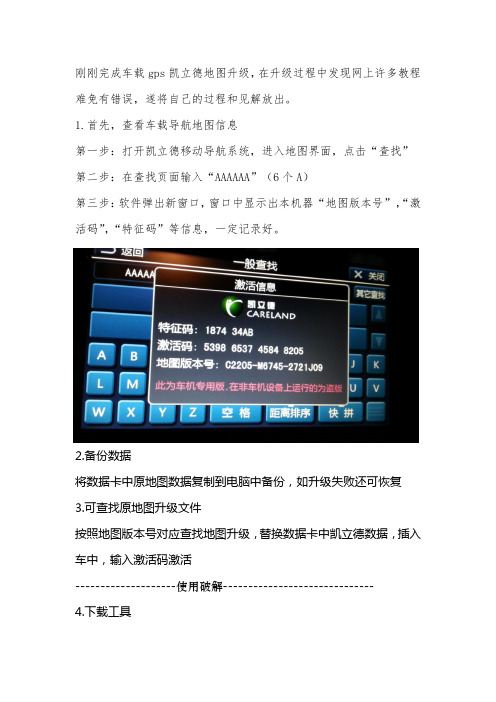
1.首先,查看车载导航地图信息第一步:打开凯立德移动导航系统,进入地图界面,点击“查找”第二步:在查找页面输入“AAAAAA”(6个A)第三步:软件弹出新窗口,窗口中显示出本机器“地图版本号”,“激活码”,“特征码”等信息,一定记录好。
2.备份数据将数据卡中原地图数据复制到电脑中备份,如升级失败还可恢复3.可查找原地图升级文件按照地图版本号对应查找地图升级,替换数据卡中凯立德数据,插入车中,输入激活码激活--------------------使用破解------------------------------ 4.下载工具如使用其他破解地图升级亦可,此时需要了解原地图的屏幕尺寸、gps 端口(设置不对搜不到卫星)、gps波特率(影响信号传输)等信息需要使用工具:凯立德端口配置工具、凯立德参数修改器。
我的百度盘提供下载(/s/1eQxMEL8/s/18Km0u)或网上搜一下,有很多。
5.查看参数使用凯立德参数修改器了解车载gps参数。
将凯立德参数修改器拷贝到数据卡中,打开。
拖动NaviResFile文件夹中NaviConfig.dll文件到凯立德参数修改器中打开,见下图。
记录下下图圈出的数据。
6.下载破解地图文件我是用的版本号为C1204-C7H01-3121J0H,电子眼为201403000,是凯立德2014年春季高清零售版,分辨率800X480。
默认端口COM1 波特率9600;下载地址/s/1jGDn9sE7.修改地图参数将下载得到NaviOne压缩文件夹,解压后即可得到NaviOne文件夹。
解压后的NaviOne文件夹有3.49G,请准备足够容量的存储卡。
使用“凯立德端口配置工具”打开破解地图的NaviResFile文件夹中NaviConfig.dll文件,根据记录的GPS参数修改端口和波特率两个参数。
车载GPS导航仪使用说明书
车载GPS导航仪使用说明书尊敬的用户,欢迎您购买并使用我们的车载GPS导航仪。
本使用说明书将为您提供详细的操作指南,以帮助您正确使用导航仪并获得最佳的导航体验。
一、产品概述车载GPS导航仪是一种基于全球定位系统(GPS)技术的导航设备。
它结合了卫星定位、地图数据库和导航软件,能够为您提供准确的车辆位置信息、路线规划以及导航指引等功能。
我们的产品具有以下特点:1.高精度定位:通过接收卫星信号,导航仪能够实时准确地定位您的车辆,提供精准的导航服务。
2.多功能导航:除了常规的驾车导航功能外,导航仪还提供步行、骑行等多种导航模式,并支持POI(兴趣点)搜索、线路规划等功能。
3.智能语音提示:导航仪内置语音合成技术,能够实时播报导航指引,让您无需分心看屏幕,更加安全便捷地进行导航。
二、使用方法1.前期准备在第一次使用前,请确保您已经将导航仪的电源充满,并正确插入车载支架。
您还需要安装地图数据,可通过我们提供的软件或者在线下载的方式进行。
2.开机与关机长按开关键一秒钟,导航仪即可开机启动。
在正常使用过程中,您可以通过点击界面上的关机按钮进行关闭。
3.地图操作使用触摸屏幕或者外部键盘进行地图操作。
您可以通过手势缩放、平移等方式调整地图显示区域。
另外,点击地图上的兴趣点或者目的地图标,即可进行相关操作,如导航规划、查看详细信息等。
4.导航设置导航仪提供了丰富的导航设置选项,您可以根据个人需求进行调整。
例如,您可以选择偏好路线、避开拥堵、设置声音提示等。
5.语音指引导航仪通过内置扬声器进行语音指引。
在导航过程中,您会听到详细的导航提示,包括转向指示、距离提示等。
您还可以根据需要调整音量大小或者关闭语音指引。
6.兴趣点搜索导航仪允许您搜索周边的兴趣点,如餐馆、加油站、酒店等。
您可以直接在搜索框中输入关键词,系统会为您提供相关的搜索结果,并进行导航到达。
三、常见问题与解答1.为什么导航仪无法定位?请确保导航仪在开放的区域使用,避免遮挡。
GPS导航器手册说明书
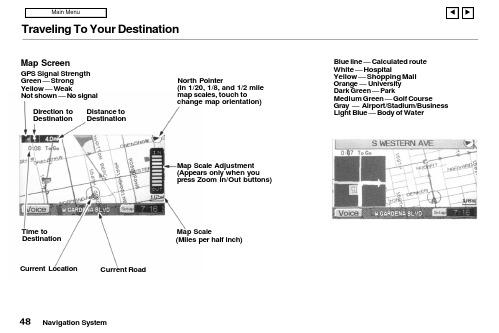
Traveling To Your DestinationBlue line — Calculated route White — HospitalYellow — Shopping Mall Orange — University Dark Green — ParkMedium Green — Golf CourseGray — Airport/Stadium/Business Light Blue — Body of WaterNavigation SystemMap ScreenGPS Signal Strength Green — Strong Yellow — WeakNot shown — No signalDistance to DestinationDirection to DestinationNorth Pointer(In 1/20, 1/8, and 1/2 mile map scales, touch tochange map orientation)Map Scale Adjustment (Appears only when you press Zoom In/Out buttons)Map Scale(Miles per half inch)Current RoadCurrent Location Time toDestinationTraveling To Your DestinationLandmark IconsLandmark icons will be shown in the screen if you select the "Show Icon on Map" in the "Set-up Screen". See "System Setup" on page 60.Going Off the RouteIf you leave the calculated route,"Off-route" (manual) or"Recalculating" (automatic) is displayed at the top of the screen.The system will recalculate the route from your current location anddirection to the desired destination;then give you a new route instruction.This recalculation is doneautomatically unless you set it to manual in the Setup Menu. See "System Setup" on page 60.Auto RecalculationIf this option is set to "Automatic"you will see. "Recalculating" flash at the top of the screen for several seconds as the system recalculates the route. This is followed by a new route instruction.Manual RecalculationIf this option is set to "Manual", you will hear a tone when the "Off-route"message is displayed. You must press the Joystick or "ReCal" icon in the screen before the system will recalculate your route.Navigation SystemTraveling To Your DestinationModifying the RouteSeveral functions in the system allow you to view the route the system has calculated. You can then have the system recalculate portions of the route. This is helpful if you are aware of road conditions along the calculated route that you wish to avoid.With the map screen displayed, you can push the MAP/GUIDE button at any time to display the guidance screen. With the guidance screen displayed, move the Joystick left or right to see the Direction List. This shows you all the route instructions between your current location and your destination.Instructions that have already been executed cannot be displayed.Push the joystick down to see the upcoming route instructions one at a time. Each push displays the next in-struction in the sequence. Push the joystick up to move backwardthrough the sequence to the current instruction. The display returns to the current route instruction in about 10 seconds if you stop pushing on the joystick.Navigation SystemTraveling To Your DestinationPressing the MENU button with either the map screen or theguidance screen displayed changes the display to:This menu lets you cancel or modify the current calculated route.DetourSelect this option if you encounter an unexpected obstacle, such as a closed road or extremely heavy traffic congestion. The system will calculate a route from your current location that detours you off the original route, and then back onto it after a certain distance.Avoid a StreetThis option lets you delete a street or streets from the current calculated route. This is helpful if you know of road construction or other snags on the prescribed route.Plan New TripSelecting this option cancels the current route and destination. The display returns to the "Main Menu".Back to Current RouteSelecting this option returns you to the original guidance screen.Navigation System。
凯立德导航安卓零售版使用说明

凯立德【安卓零售版】使用说明一、界面和操作介绍:安卓零售版与车机的界面基本相同了,横屏显示,界面介绍如下(为便于介绍PS了下,后附具体说明):(一)浏览界面:1.路径规划:包括目的地、出发地、地址薄(家园版叫收藏夹),在导航状态下浏览地图时还会出现经由地选项。
此界面与浏览标(家园版叫光标了)、返回同时出现,需要在进入系统后或者在导航过程中长按屏幕(家园版为轻触)进入。
2.出发地、经由地(可选)和目的地:进入系统时只有车标和出发地或者代表当前位置的绿色圆点,在导航模式下才会出现目的地,如果有设置还会出现经由地。
3.指示栏:这里包括提示设置(可以选择安全、标准、简明三种提示方式)、地图模式设置(地图正北、图随车转、俯视图)和GPS指示。
4.电子眼:可以快速添加电子眼信息。
5.k码:进入k码显示和定位功能。
6.地图缩放和比例尺显示:比家园版多了个比例尺的显示。
7.底部菜单栏:包括功能(包含设置等,同家园版)、查找、常用(相当于家园版导航管理)、周边(快速查找目的地、导航路径、车标或浏览标周围的特定分类兴趣点)。
在它右边的三角箭头可以显示或者隐藏底部状态栏,再右边显示系统时间(导航模式下显示选路方式、剩余里程、剩余时间等信息)。
上方一点显示车标或者浏览标的地理位置(导航模式下还显示当地广播电台名称、频率)。
(二)导航界面:1.行程说明:进入行程说明界面,可以选择浏览或避开某一段路径。
2.目的地指示:显示目的地的名称。
3.复诵:点击可复诵上一次语音提示信息。
Ps:此图为俯视图模式,前方可以看得更远。
(三)操作介绍:1.地图移动:长按地图进入浏览模式,地图操作与家园版不同,移动地图时需点击目的位置,不支持地图拖拽。
2.定位:快速移动到该兴趣点所在位置,可以点击“上一个”、“下一个”定位到同列表中的其他兴趣点,也可以点击“周边”进入周边快速搜索。
3.改变位置和设定:进入浏览界面并定位到该兴趣点,移动地图到需要的位置后可以点击左侧的“设定”来完成对兴趣点的重新定位。
凯立德配置文件说明

20B0 2150 21F0 2290 2330 23D0 2470 2510 26F0
//是否将激活信息写到 HWINFO.cld 文件中
为 0:否,为 1:是
为 0:用 16 位色,为 1:用 24 为色
为 0:简体输入,为 1:繁体输入
//有些机器上计算声音播放的时间的不准,用这个变量来手动调整
100 米显示小路
0x34b0h (0 为禁用,1 为开启)
屏幕校准功能
(0 为禁用,1 为开启) (模拟器未能使用,真机测试也不一定能够使用,怀疑少某个文 0x3550 h 件或者程序)
TMC 功能
0x3910h (0 为禁用,1 为开启) 需主程序支持 TMC 功能
声音变大
初始化的时候是否设置出发地的名称,为空不设置
是否有退出导航系统功能,
为 0:否;为 1:是
是否有退出导航警告界面,
为 0:否;为 1:是
地图缓冲区大小
触摸屏连续移动的速度
键码移动地图的速度
鼠标松开后多长时间自动获取文字(ms)
是否删除自动激活文件,
为 0:不删除,为 1:删除
FD0 1070 1110 11B0 1250 12F0 1390 1430 14D0 1570 1610 16B0 1750 17F0 1890 1B10 1BB0
1C50 1CF0 1D90 1E30 1ED0 1F70 2010
是否需要 TTS,
=0:不需要,=1 需要
Байду номын сангаас地图初始 x位置
地图初始 y位置
凯立德配置文件说明:
Navigator GPS 地图导航系统用户指南说明书

Traveling To Your DestinationBlue line — Calculated route White — HospitalYellow — Shopping Mall Orange — University Dark Green — ParkMedium Green — Golf CourseGray — Airport/Stadium/Business Light Blue — Body of WaterNavigation SystemMap ScreenGPS Signal Strength Green — Strong Yellow — WeakNot shown — No signalDistance to DestinationDirection to DestinationNorth Pointer(In 1/20,1/8, and 1/2 mile map scales, touch tochange map orientation)Map Scale Adjustment (Appears only when you press Zoom In/Out buttons)Map Scale(Miles per half inch)Time toDestination Current LocationCurrent RoadTraveling To Your DestinationLandmark IconsLandmark icons will be shown in the screen if you select the "Show Icon on Map" in the "Set-up Screen". See "System Setup" on page 60.Going Off the RouteIf you leave the calculated route,"Off-route" (manual) or"Recalculating" (automatic) is displayed at the top of the screen.The system will recalculate the route from your current location anddirection to the desired destination;then give you a new route instruction.This recalculation is doneautomatically unless you set it to manual in the Setup Menu. See "System Setup" on page 60.Auto RecalculationIf this option is set to "Automatic"you will see. "Recalculating" flash at the top of the screen for several seconds as the system recalculates the route. This is followed by a new route instruction.Manual RecalculationIf this option is set to "Manual", you will hear a tone when the "Off-route"message is displayed. You mustpress the Joystick or "ReCal" icon in the screen before the system will recalculate your route.Navigation SystemTraveling To Your DestinationModifying the RouteSeveral functions in the system allow you to view the route the system has calculated. You can then have the system recalculate portions of the route. This is helpful if you are aware of road conditions along the calculated route that you wish to avoid.With the map screen displayed, you can push the MAP/GUIDE button at any time to display the guidance screen. With the guidance screen displayed, move the Joystick left or right to see the Direction List. This shows you all the route instructions between your current location and your destination.Instructions that have already been executed cannot be displayed.Push the joystick down to see the upcoming route instructions one at a time. Each push displays the next in-struction in the sequence. Push the joystick up to move backwardthrough the sequence to the current instruction. The display returns to the current route instruction in about 10 seconds if you stop pushing on the joystick.Navigation SystemTraveling To Your DestinationPressing the MENU button with either the map screen or theguidance screen displayed changes the display to:This menu lets you cancel or modify the current calculated route.DetourSelect this option if you encounter an unexpected obstacle, such as a closed road or extremely heavy traffic congestion. The system will calculate a route from your current location that detours you off the original route, and then back onto it after a certain distance.Avoid a StreetThis option lets you delete a street or streets from the current calculated route. This is helpful if you know of road construction or other snags on the prescribed route.Plan New TripSelecting this option cancels the current route and destination. The display returns to the "Main Menu".Back to Current RouteSelecting this option returns you to the original guidance screen.Navigation System。
凯立德导航使用说明

凯立德移动导航使用指南城市的道路建设以及汽车数量的增长十分之快,开着车穿梭于各大城市的朋友也越来越多,交叉如网状的道路相信会让不少开车的朋友迷茫不已。
正因为如此,有一个好的GPS全球卫星定位系统是很必要的。
今天我们就为大家介绍一下凯立德移动导航系统。
凯立德移动导航系统有两种安装方法,在选择了相应地区的地图及软件进行解压安装的时候程序会有提示,一种是通过同步的模式进行安装,另一种是将程序拷贝到存储卡上进行安装,两种安装方式由于安装文件即较大,数据线同步安装的方式过于缓慢,于是在安装的时候建议选用最快的存储卡安装方式(安装完成之后需创建一个快捷方式至程序菜单)。
不管采取何种安装方式,存储卡上必须有充足的空间,本次测试安装的是珠江三角洲地区的地图,所占的空间约为68M,如果要安装全国的导航地图则需要有一张剩余空间为512M以上的存储卡。
在程序安装完毕之后,首次运行时,输入根据每台手机唯一的设备识别码捆绑的激活码之后,即可开始正式使用凯立德移动导航系统了。
本次采用了GS-R232蓝牙GPS卫星接收机进行测试,体积小巧的卫星接收机适合放置在汽车的仸何位置,内置锂电池的设计,不仅适合车载使用,也适合在城市内的行走使用,内置的锂电池在全程GPS的定位使用下大概能够维持将近10个小时的使用。
长按GS-R232蓝牙GPS卫星接收机上的按键开启电源之后,接收机便自动进行卫星的寻找定位。
在空阔的地方,GS-R232的定位速度较快,大概在1~2分钟之内,而在高楼林立的城市内则需要3~5分钟的定位时间。
定位成功之后,长亮的橙色小灯则转为闪烁的状态。
在蓝牙GPS接收机成功的进行定位之后,开启凯立德移动导航软件,为了能够保障驾驶者的安全,软件会提示相关的注意事项,例如交通使用安全等事项。
按确认后即可进入程序的主运行界面,地图的界面便显示在屏幕上,默认坐标位置附近的建筑物或道路也会同时显示。
程序的地图有3种显示方式,分别为地图正北、随着行进方向旋转、以及鸟瞰图,用户可根据自己的习惯来进行选择,在使用的过程中,驾驶员则认为鸟瞰图的方式是最好的查看方式。
凯立德导航软件使用说明

凯立德手机导航软件v3.02最新版下载说明0907凯立德, 手机, 软件, 导航, 下载新数据、新引擎、新功能、新设计、全新地图,凯立德手机导航软件将再次引领新一轮的手机导航流行风潮。
2009年7月初,凯立德手机导航软件又进行了一次大的版本升级,目前最新版本已经升级到V3.02。
此次更新后的软件版本将广泛的适用于Symbian S60V3、Windows Mobile 5.0/6.0/6.1及以上系统且具备GPS导航功能的大部分手机和部分Linux导航手机。
下载方式:请登录/down.php,进入以后选择自己的机型就可以下载了。
因为专业,所以心系关怀作为中国GPS导航软件第一品牌的凯立德,在导航领域的10年发展,其产品的专业性已经被广大用户所认可,所获得的各种奖项更是被业内人士所肯定。
此次发布的凯立德手机导航软件产品在之前众多产品的基础上除了为用户提供了更加专业的电子地图和导航功能外,软件的操作也更加人性化,无处不体现着软件对用户的关怀以及对用户真正需求的满足。
全功能全覆盖的免费贴身电子地图此次的版本升级,凯立德手机导航软件不仅为广大用户提供了基础导航数据的免费升级下载服务,同时还大范围的扩充了电子地图的兴趣点(POI)信息,为广大导航用户提供覆盖全国路网和包含750万个以上精确兴趣点(POI)的电子地图。
道路总里程200万公里,含括4个直辖市,33个省级行政区域(包含香港、澳门)以及25个省会城市,333个地级市,2862个县级行政单位,3万个乡镇级行政单位,部分沿海城市及经济发达地区,基本实现村村通。
软件本身还提供基于电子地图的免费地图浏览功能、快速查找目的地和兴趣点(POI)功能,极大的丰富了导航类手机软件的功能。
专业导航按需付费此次升级的凯立德手机导航软件为用户提供免费下载获取,免费导航服务,每次语音导航收取人民币2元的导航服务费用(不含GPRS流量费),不导航不收费。
相比众多的PC和PND (便携式自导航系统)导航软件几百元甚至上千元的导航费用来说可谓是为用户极大的节约了使用费用。