长江 介绍 简介
关关于长江三峡
--关于长江三峡:是一个令无数国人心向往之的地方,于是收集了一些资料,是否抄袭?不过,还是决定下一些功夫,整理了一下,也许有些用处。
一、长江三峡简介长江三峡是重庆市至湖北省间的瞿塘峡、西陵峡和巫峡的总称。
西起重庆的奉节,东至湖北的宜昌,全长192千米。
自西向东主要有瞿塘峡、巫峡和西陵峡等三个大的峡谷地段,三峡因此得名。
三峡两岸高山对峙,崖壁直立,山峰一般1000---1500米。
江面狭窄,最窄处不足百米,水流湍急。
水道曲折多险滩,舟行峡中,有「石出疑无路,云升别有天」的境界。
自白帝城至黛溪称瞿塘峡,巫山至巴东官渡口称巫峡,秭归的香溪至南津关称西陵峡。
长江三峡,中国10大风景名胜之一,中国40佳旅游景观之首,是长江上最为奇秀壮丽的山水画廊。
除此之外还有大宁河的“小三峡”和马渡河的“小小三峡”。
这里两岸高峰夹峙,港面狭窄曲折,港中滩礁棋布,水流汹涌湍急。
“万山磅礴水泱漭,山环水抱争萦纡。
时则岸山壁立如着斧,相间似欲两相扶。
时则危崖屹立水中堵,港流阻塞路疑无。
”郭沫若同志在《蜀道奇》一诗中,把峡区风光的雄奇秀逸,描绘得淋漓尽致。
我国古代有一部名叫《水经注》的地理名著,北魏时郦道元编著,书中关于三峡的生动叙述:“自三峡七百里中,两岸连山,略无阙处。
重岩叠嶂,隐天蔽日,自非亭午夜分,不见曦月,至于夏水襄陵,沿溯阻绝。
或王命急宣,有时朝发白帝,暮到江陵,其间千二百里,虽乘奔御风,不以疾也。
春冬之时,则素湍绿潭,回清倒影。
绝巘多生怪柏,悬泉瀑布,飞漱其间。
清荣峻茂,良多趣味。
每至晴初霜旦,林寒涧肃,常有高猿长啸,属引凄异,空谷传响,哀转久绝。
故渔者歌曰:“巴东三峡巫峡长,猿鸣三声泪沾裳!”。
三峡地跨两省。
两岸崇山峻岭,悬崖绝壁,风光奇绝,规模巨大的三峡工程的建成,“高峡出平湖,神女应无恙,当惊世间殊”,这是何等的情怀,如今变为现实,三峡不再像当年那样激流险滩。
三峡旅游区优美景区众多,其中最著名的丰都鬼城,忠县石宝寨,云阳张飞庙,瞿塘峡,巫峡,西陵峡,宏伟的三峡工程,大宁河小三峡等。
中国37条河流名称
中国37条河流名称长江、黄河、黑龙江、珠江、松花江、澜沧江(湄公河上游)、雅鲁藏布江、怒江(萨尔温江上游)、淮河、辽河、海河、黄河支流渭河、黄河支流汾河、乌苏里江、钱塘江、闽江、黄河支流洛河、黄河支流无定河、塔里木河、伊犁河、额尔齐斯河、黄河支流湟水、黄河支流洮河、黄河支流大黑河、黄河支流窟野河、黄河支流汾川河、黄河支流沁河、黄河支流北洛河、黄河支流金堤河、黄河支流祖厉河、黄河支流皇甫川、嘉陵江(长江支流)、汉江(长江支流)、岷江(长江支流)、湘江(长江支流洞庭湖水系)、沅江(长江支流洞庭湖水系)、赣江(长江支流鄱阳湖水系)中国的河流众多,其中流量最大的37条河流涵盖了广泛的地理区域和多样的水文特征。
以下是对其中部分主要河流的名称及简介,由于篇幅限制,无法一一列举37条河流的详细介绍,但将尽量涵盖流量较大且具有代表性的河流:1. 长江长江是中国第一大河,也是世界第三长河,仅次于亚马逊河和尼罗河。
它发源于青藏高原的格拉丹东雪山,全长6300公里,流域面积180万平方公里,年径流量约10000亿立方米,占全国河流年径流量的1/3以上。
长江干流横穿青海、西藏、云南、四川、重庆、湖北、湖南、江西、安徽、江苏、上海等11个省、市、自治区,先后汇集700多条大小支流。
长江沿岸景色壮丽,自然景色兼有东西南北的不同特点,同时,长江水道也是一条有重要航运价值的交通线,素有“黄金水运”之称。
2. 黄河黄河是中国第二大河,干流全长5464公里,发源于青海巴颜喀拉山北麓的各姿各雅山,流经青海、四川、甘肃、宁夏、内蒙古、陕西、山西、河南及山东9个省份,流域面积达75万多平方公里。
黄河中游段流经黄土高原地区,许多支流夹带着大量泥沙汇入,使黄河成为世界上含沙量最高的河流,河水呈黄色,因而得名。
3. 黑龙江黑龙江自发源地至入海口全长4350公里(中国境内3420公里),流域面积184.3万平方公里(中国境内90万平方公里)。
黑龙江上游流经森林茂密、水草丛生的地区,两岸土壤含黑色腐殖质溶解于水中,因而江水呈黝黑色。
长江中下游地区旅游资源介绍
湖北省
湖北旅游资源丰富,山水名胜与 文物古迹二者兼备。人誉“第一 山”的道教名山武当山为道教圣 地。号称“华中屋脊”和 “绿 色宝库”的神农架是重要自然保 护区,不仅珍稀动物种多,“野 人之谜”更令人关注。
湖北的地理环境特点(自然的) 地理: 湖北省位于长江中游、因地处洞庭湖以北,故称湖北。地理位置为东经108°21'116°07',北纬29°05'-33°20'。面积18.6万平方公里。中南部为江汉平原,其余为鄂西山地、 鄂北网地与鄂东低山丘陵。北靠河南,南接江西、湖南,东邻安徽,西依四川,西北与陕西接 壤。东西宽740.6公里,南北长470.2公里。 旅游资源:雄伟的长江三峡驰名世界。七十二峰朝大顶, 二十四涧水长流,人誉“第一山”的道教 名山武当山武当山为道教圣地。号称 “华中屋脊”和“绿色宝库”的神农架是重要自然保护区, 不仅珍稀动物种多,“野人之迷”更令人关注。湖北人文旅游景观具有时代跨度大, 历史价值 高的特点, 这里既有古人类长阳人遗址, 屈家岭文化遗址, 又有众多的古三国胜迹和楚都遗址 “纪南城”; 既有辛亥革命遗址起义门、阅马场、又有中央农民运动讲习所旧址及“八七会议” 会址。文物古迹与革命胜迹遍布全省。
两岸泊舟无数,宿醉未 醒的船夫从晨曦中的吊 脚楼边匆匆跳到船头, 妖冶泼辣的女子在楼头 挽留相好的船夫,被山 匪抢了媳妇的小裁缝垂 着泪锁纽扣。”(沈从 文《边城》)
岳麓书院位于湖南省长沙市湘江西岸的国家4A 级风景名胜岳麓山风景区,为中国古代著名四 大书院之一;1988年,岳麓书院建筑群被国务 院批准为第三批国家重点文物保护单位,现为 岳麓山风景区重要观光点。书院始建于北宋开 宝九年(公元976年),一千余年来,这所誉满 海内外的著名学府,历经宋、元、明、清时势 变迁,迨及晚清(1903年)改制为湖南高等学堂, 1926年正式定名为湖南大学。“千年学府,弦 歌不绝”,至今书院仍为湖南大学下属的办学 机构面向全球招生。
关于长江三峡导游词经典五篇范文

关于长江三峡导游词经典五篇范文长江三峡东起湖北宜昌南津关,西至重庆市奉节县白帝城,由西陵峡、巫峡、瞿塘峡组成,全长193公里。
下面是带来的关于长江三峡的导游词,希望大家喜欢。
关于长江三峡的导游词1大家好,欢迎大家来到美丽的长江三峡旅游观光。
正如大家所知道的,长江是我国的第一大河,它发源于青海省唐古拉山脉的西南侧,流经青海,西藏,云南,四川,重庆,湖北,湖南,江西,安徽,江苏,上海等11个省市。
纳百川千流,自西向东,横贯中国腹地,最后注入东海。
全长6300公里,是仅次于南美亚马逊和刚果河的世界第三大河流,它孕育了中华民族古老文明,更与山融合而成了壮丽雄奇、举世无双的峡谷长江三峡。
长江三峡西起重庆奉节白帝城,东至湖北宜昌南津关,由雄伟壮观的瞿塘峡、幽深秀丽的巫峡和滩多水急的西陵峡组成,全长193公里。
瞿塘峡以雄著称,西起重庆奉节白帝城,东至大溪镇,峡长虽然只有短短的8千米,是三峡中最短的一个,却有着西控巴蜀收万壑,东连荆楚压群山之势。
接着就是以秀出名的巫峡,巫峡因巫山而出名,西起重庆巫山城东的大宁河口,东至湖北巴东县的官渡口,是三峡中的唯一一个地跨两省市的峡谷,全长45公里。
船在巫峡中行,时而大山当前,时而峰回路转,山穷水复疑无路,柳暗花明又一村无疑是它最好的写照。
所以有人把巫峡比喻作一条迂回曲折的山水画廊。
最后经过一段山舒水缓的宽谷地带,我们便来到西陵峡。
风光绮丽的西陵峡,西起秭归县香溪河口,东至湖北宜昌南津关,全长76公里,是长江三峡中最长的峡谷。
因位于楚之西塞和夷陵也就是现在的宜昌市的西边,故称西陵峡。
西陵峡以险出名,以奇著称,奇险化为西陵峡的壮美。
相信大家必定听说过这几句诗:朝发白帝彩云间,千里江陵一日还,两岸猿声啼不住,轻舟已过万重山。
这脍炙人口的诗句,正是来源于诗仙李白的名作《朝发白帝城》,而这里所说的白帝城,正是我们今天所参观第一个景点。
位于长江北岸的白帝城,原名紫阳城,它是新莽时期公孙述割据四川之际建筑的,因为传说城中有井,井中白雾腾空,其形状宛如一条白龙,直冲九霄,于是公孙述自称白帝,城也改名白帝城。
初中北师大版语文七年级下册第1课《长江》简介
长江简介长江古名为江,又称“大江”。
发源于唐古拉山主峰各拉丹东雪山西南侧(北纬33°28’,东经91°08’),源头冰川未端海拔5400余米。
干流流经青海、西藏、四川、重庆、湖北、湖南、江西、安徽、江苏和上海等11个省(市、自治区),在崇明岛以东注入东海,全长6393公里,仅次于南美洲的亚马逊河和非洲的尼罗河。
支流展延到甘肃、陕西、贵州、河南、浙江、广西、福建和广东等8个省(自治区),有雅砻江、岷江、沱江、嘉陵江、乌江、湘江、汉江、赣江、青弋江和黄浦江等支流,流域面积达180万平方公里,约占全国总面积的18.75%。
长江江源至河口,整个地势西高东低,横贯我国三大阶梯,总落差5400米左右,多年平均入海水量近1万亿立方米,占中国河川径流总量的36%左右,相当于黄河水量的20倍。
长江在江苏省镇江市同大运河相交。
长江是我国第一大河,从长度来讲,长江排在非洲埃及的尼罗河、南美洲的亚马逊河之后,居第三位;从水量来讲,长江排在亚马逊河(年入海流量6万亿立方米)、非洲的刚果河、南美洲的奥里诺科河之后,居第四位。
长江水系发育,支流数以千计,流域面积1万平方公里以上的支流有49条,嘉陵江、汉江、岷江、雅砻江4大支流的流域面积均在10万平方公里以上。
长江中下游是中国淡水湖分布最集中的地区,主要有鄱阳湖、洞庭湖、大湖、巢湖等。
长江古名江,又称大江,六朝以后,通称“长江”。
近代不少国家把整条长江称为扬子江。
长江各段名称和别名总计不下30种。
一般常用的分段名称有:从江源至当曲口(藏语“曲”即“河”),长358公里,称沱沱河,为长江正源;当曲口至青海省玉树县巴塘河口,长813公里,称通天河;巴塘河口至四川省宜宾市岷江口,长2308公里,称金沙江;岷江口至长江入海口,长2884公里(荆江裁弯取直后,缩短航程80公里,为2800余公里),通称长江。
其中,宜宾至湖北省宜昌市,因长江大部分流经四川省境内,俗称川江,长1030公里。
长江三峡简介

三峡是万里长江上最为奇秀的一段,是大自然的鬼斧神工造就的山水画廊。
其间全长193公里。
三峡位于长江中游,西起四川奉节白帝城,东至湖北宜昌南津关,其中有瞿塘峡、巫峡、西陵峡被称为长江三峡。
瞿塘峡以“雄”著称,巫峡以“秀”见长,西陵峡以“险”著称。
三峡群峰夹峙,悬崖千丈,风光雄伟壮丽,风景如画。
瞿塘峡长八公里,河道很深,山势高峻,雄伟险峻;瞿塘峡西口叫夔门,两座山峰夹并耸立,汹涌的江水夺门而过,江面仅宽150米,有的地方甚至不到100米。
巫峡长逾四十公里,幽深秀丽,由于常年累月受江水冲刷,沟益深,峰峦益挺拔,直到过了官渡口,方见宽谷缓坡之中村落如星点散布,大有"石出疑无路,云开别有天"的感觉。
西陵峡长七十五公里,是最长的一个峡,以“险闻名,夹岸悬崖绝壁横空,峡中有峡,滩中有滩,滩多水急。
三峡的大宁河小三峡峰秀、滩险、景幽、石美,不可错过。
长江三峡简介

张敏霞 河南理工大学 2013年09月09日
1
三峡工程概况
2
一、长江三峡
长江——祖国的母亲河 长江发源于青海唐古拉山,流经祖国中部的
9个省和2个直辖市,于上海市流入东海,全长 6300余公里,是我国第一大河,世界第三大河。 长江流域面积180万平方公里,涵盖或部分涵 盖16个省(市、自治区)。
54
(3)遇1954年规模的洪水时三峡工程可防洪范围
55
56
(4)截流工程
57
1998年二期围堰施工
Construction of the Phase Ⅱ
58
59
(5)船闸工 程
船舶过闸
60
61
62
(6) 水轮机 吊装
Lifting Runner of the Turbine
63
64
35
三、枢纽主要建筑物
(1)泄流坝全景
36
37
(2)电站 三峡电站施工中 的电站进水管
38
3. 船闸 双线五级船闸 进水调试
39
正在进行混凝土浇筑的双线五级船闸
40
1993——1997 施工开始到主河床截流 1998——2002 主坝施工到右明渠截流 2003——2009 建右岸围堰,船闸,全坝竣 工
3
万里长江源头——唐古拉山脉主峰各拉丹东雪山, 海拔6621米,这里云雾缭绕,银装素裹,山势险峻, 沟谷纵横。
4
长江正源 沱沱河,发源 于各拉丹东雪 山西南侧的两 条大冰川。巨 大的冰川在阳 光下消融,竟 成为万里长江 不尽之源。
5
流域面积180万平方公
里
6
2. 三峡 雄伟的瞿塘峡
7
长江流域简介(英文)
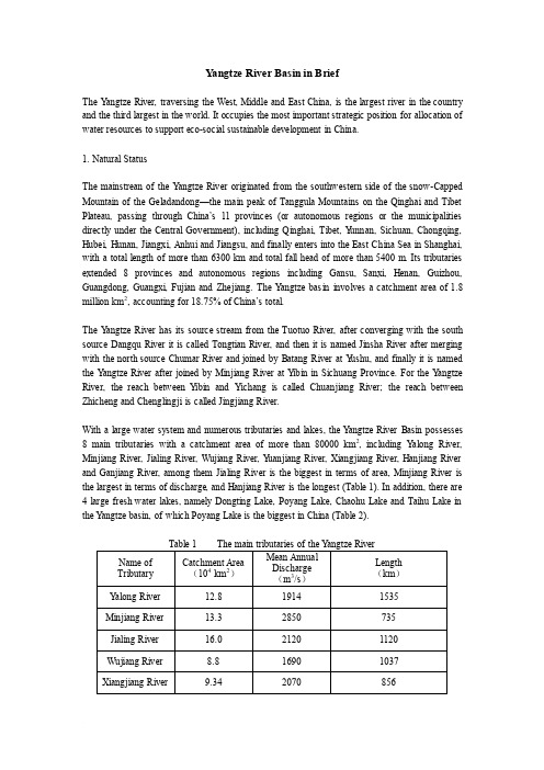
Y angtze River Basin in BriefThe Y angtze River, traversing the West, Middle and East China, is the largest river in the country and the third largest in the world. It occupies the most important strategic position for allocation of water resources to support eco-social sustainable development in China.1. Natural StatusThe mainstrean of the Y angtze River originated from the southwestern side of the snow-Capped Mountain of the Geladandong—the main peak of Tanggula Mountains on the Qinghai and Tibet Plate au, passing through China’s 11 provinces (or autonomous regions or the municipalities directly under the Central Government), including Qinghai, Tibet, Y unnan, Sichuan, Chongqing, Hubei, Hunan, Jiangxi, Anhui and Jiangsu, and finally enters into the East China Sea in Shanghai, with a total length of more than 6300 km and total fall head of more than 5400 m. Its tributaries extended 8 provinces and autonomous regions including Gansu, Sanxi, Henan, Guizhou, Guangdong, Guangxi, Fujian and Zhejiang. The Y angtze basin involves a catchment area of 1.8 million km2, accounting for 18.75% of China’s total.The Y angtze River has its source stream from the Tuotuo River, after converging with the south source Dangqu River it is called Tongtian River, and then it is named Jinsha River after merging with the north source Chumar River and joined by Batang River at Y ushu, and finally it is named the Y angtze River after joined by Minjiang River at Y ibin in Sichuang Province. For the Y angtze River, the reach between Y ibin and Yichang is called Chuanjiang River; the reach between Zhicheng and Chenglingji is called Jingjiang River.With a large water system and numerous tributaries and lakes, the Y angtze River Basin possesses 8 main tributaries with a catchment area of more than 80000 km2, including Y along River, Minjiang River, Jialing River, Wujiang River, Y uanjiang River, Xiangjiang River, Hanjiang River and Ganjiang River, among them Jialing River is the biggest in terms of area, Minjiang River is the largest in terms of discharge, and Hanjiang River is the longest (Table 1). In addition, there are 4 large fresh water lakes, namely Dongting Lake, Poyang Lake, Chaohu Lake and Taihu Lake in the Y angtze basin, of which Poyang Lake is the biggest in China (Table 2).The section upstream of Y ichang is known as the upper reaches with a length of 4500 km and a catchment area of 1,000,000 km2. From Y ichang to Hukou, the river enters into the middle reach with a length of 950 km and a catchment area of 680,000 km2. The section downstream from Hukou to the estuary is the lower reach with a length of 930 km and a catchment area of 120,000 km2. The upper Y angtze runs through Alps-Ravines with steep slope and rapid flow except in a small section of the source area, the total water head reaches 5100 m, accounting for 95% of the total of the River. The reach from the mouth of Batang River to Y ibin is 2300m long with an average slope of 1.37‰;the Tiger-leaping Gorge in downstream of Shigu of Jinsha River is a world famous peculiar gorge, with a length of 17 km, a water head of 170 m, a gorge depth of 2500~3000 m, and a river width of only 30 m in the narrowest part. The reach from Yibin to Chongqing is 370 km long with an average slope of 0.27‰; the reach between Chongqing and Yichang is 660 km long with an average slope of 0.18‰, of which the 192 km reach from Fengjie to Yichang is the famous "Three Gorges" (Qutang Gorge, Wuxia Gorge and Xiling Gorge). Downstream from Y ichang, the river flows into the middle-lower alluvial plain with flat topography on both banks, and with an average slope of 0.03‰ between Yichang and Hukou and 0.007‰ for the reach from Hukou to the estuary, of which the part of about 600 km long downstream from Datong in Anhui province belongs to tide influenced reach.For the terrain of the Y angtze River basin, it is high in west and low in east through Chin a’s three major topographic cascades. The first cascade is composed of the Southern Qinghai Plateau, the Western Sichuan Plateau and the Hengduan mountainous region, with an average elevation of 3500~5000 m. The second cascade is composed of Qinba mountainous region, Sichuan Basin, Y unnan-Guizhou Plateau and the mountainous regions of Hubei and Guizhou provinces, with an average elevation of 500~2000m. The third cascade is composed of Huaiyang mountainous region, the hills in the southern area and the Middle-Lower Y angtze Plain, with an average elevation of less than 500m. The terrain of the Y angtze River Basin is complicated, consisting of 84.7% of mountain and hilly land, 11.3% of plain region, and 4% of water surface.Most of the Y angtze River Basin is situated in the middle-latitude subtropical region with monsoon climate and abundant rainfall. The mean annual precipitation is about 1100 mm, the total volume of water resources is 996 billion m3 accounting for 35.1% of the total in China.. The basin has a theoretical hydropower potential of 277810MW (2433.6 TWh/year), accounting for about 40% of nation’s total; a technically feasible potential of 256270 MW (1187.9 TWh/year), and an economically feasible potential of 228320 MW (1049.8 TWh/year), accounting for 48% and 60% of the nation’s total respectively. 90% of the hydro-energy resources in the Y angtze Basin are concentrated in the upper basin and will mainly be exploited by building large-scale hydropower stations (73% of the total), including 52 large hydropower stations with an installed capacity of more than 1000 MW each, and the largest one ---the Three Gorges Hydropower Station reaches 22400 MW (90 TWh/year). There are 3600 navigable channels in the Y angtze basin, mainly distributed in the middle and lower basin with the inland waterway mileage of 66386 km, accounting for 49.1% of nation’s total. After completion of the Three Gorges Project(TGP), 10000-ton towboats will be able to pass through right up to Chongqing portThe Y angtze basin is rich in aquatic biodiversity, according to investigation, there are more than 370 fish species, of which one third are endemic species, the output of the main commercial fish –―Four family fishes‖ (Chinese carps) account for 60% of the nation’s total. The Y angtze is also the home of some rare species, of which Chinese river dolphin ( Baiji ) ,Chinese paddlefish, Chinese sturgeon and Y angtze sturgeon are in Class I , while Chinese finless porpoise and Chinese sucker are in Class II on the list of the nation protected species. . In recent years, as a result of increasing human activity, some species are in danger of extinction,the biodiversity has been showing a declining trend in the basin.The mean annual content of suspended sediment in the Y angtze water is less than 1kg/m3, however, due to the huge runoff, annually more than 486 Mt of sediments are discharged into the sea. In recent years, due to the effect of reservoir formation and soil & water conservation measures implemented the SS content in the Y angtze water and sediment discharge have been reduced significantly (see Table 3).Table 3 Sediment in the Y angtze RiverHydrological Station Catchmentarea(km2)Sediment content (kg/m3) Annual averagesediment discharge (Mt) 1956~1979 1980~2000 1956~1979 1980~2000Yichang 1005501 1.17 1.10 514 486Hankou 1488036 0.62 0.52 426 375Datong 1705383 0.55 0.48 470.17 430.422 Natural Disasters and Ecology and EnvironmentThe Y angtze Basin is one of the most serious regions suffering flood disasters in China, where rainfalls are concentrated and floods and water-loggings often occur in flood season, especially in the Middle and Lower Y angtze Plain. According to historical records, in last 2000 years from Western Han Dynasty to the late Qing Dynasty(206 B.C. to 1911 A.C.), there were 214 flooddisasters, once every 10 years on average. In 20th century, the floods in 1931, 1935, 1954 and 1998 were the heaviest ones causing severe damage and losses. Moreover, droughts often occur in Y unnan-Guizhou Plateau, Sichuan valley and hilly areas in the middle and lower basin.Due to the huge quantity and good quality, the Y angtze River has been an excellent water source for industrial, agricultural and domestic uses, besides, it is also excellent habitats for aquatic biota. However, along with the population increase and rapid economic growth, the amount of sewage and wastewaters discharged into the Y angtze has been increasing significantly in recent decades, in 2005 the sewage drainage reached 29.64billion tons, of which 20.4billion tons are industrial wastewaters and 9.24 billion tons are domestic sewages, as a result, water quality of the Y angtze has been deteriorating. The main pollutants are NH3-N and organic matters. In general, the water quality in the tributaries is worse than that in the main stream, the water quality in lower reaches is worse than that in the upper reaches, the water quality near riversides is worse than that in the middle stream, and the water quality in city reaches is worse than that in non-city reaches. The eutrophication of lakes in the basin is very common and Taihu Lake, Dian Lake and Chaohu Lake have been listed by the nation as the key lakes to be harnessed.According to water quality assessment carried out in 2005 on the 30000 km of river reaches in the Y angtze basin, the ratio of polluted river sections reached 27.4%, 8.5% increase compared with that in 1998, and the ratio of polluted water body in provincial boundary exceeded 40%. According to an investigation in 2002, the total near-shore pollution belt length in 21 main city sections reached 655 km, 90 km increase compared with that in 1992. For the 2608 water function zones in the basin, about 25% of them the pollution load has exceeded the permissible assimilative capacity.The upper region of the Y angtze River is one of the regions suffering the most serious soil and water losses. According to the investigation in 1990, the erosion area reached 62.2×10⁴km2, accounting for 34.6% of the basin’s total, which are mainly distributed in the upper and middle basin, especially in the upper reaches.The Y angtze Basin is the main areas infected by schistosomiasis epidemic in China, although it was once effectively controlled in 1960’s, however, it has come back again in recent years. According to the statistics in 2003, it prevailed in 110 counties in the basin including Y unnan, Sichuan, Hubei, Hunan, Jiangxi, Anhui and Jiangsu provinces with the snail distribution area of 3.79billion m2.3 Socio-economical StatusThe Y angtze River Basin involves 19 provinces (autonomous regions and municipalities), among them, 95% of the territory of Sichuan, Chongqing, Hubei, Hunan, Jiangxi and Shanghai are within the scope of the basin; and 65% for Guizhou, 35~50% for Shanxi, Anhui and Jiangsu; while for the rest provinces, less than 35% of the territory are within the basin scope.There are more than 30 nationalities living in the Y angtze Basin, among them, the Han nationalityaccounts for more than 95%; the rests are Hui, Miao, Tibetan, Zhuang, Dong, Y i, Tujia and Naxi, etc. mainly inhabiting in the upper Yangtze basin. In 2005, the inhabitants living in the basin reached 429 million, accounting for 32.8% of the China’s total, with a mean density of 238 persons/ km2, 1.8 times of nation’s average.The Y angtze Basin is mild in climate and fertile in land, and also rich in mineral resources, of which the reserve of 30 minerals exceeds 50% of China’s total;the reserve of Ti V Hg and P account for above 80~90%, and Fe, Pb, Zn, Mo, Au and Ag,etc. account for more than 30% of the nation’s total reserve.The Y angtze Basin is famous in tourism resources with many unique natural landscapes and cultural relics, including the famous Y angtze Three Gorges, Tiger Leaping Gorge, Huangshan Mountain, Lushan Mountain, Jiuhua Mountain, Emei Mountain, Jiuzhaigou and Zhangjiajie, etc. Since Tang Dynasty, the Y angtze Basin has been the economic center and the birthplace of China's modern industry. In recent years, taking Shanghai and Nanjing as the lower Y angtze center, Wuhan as the middle Y angtze center, and Chongqing, and Chengdu as the upper Y angtze center, three major economic zones have been formed in the Y angtze basin. In 2005, the GDP of the Y angtze Basin reached5996.7 billion CNY, accounting for 32.8% of nation’s total. However, presently the economic development in the basin is imbalanced, generally developed in the Delta region and relatively backward in the upper basin.4 Harnessing and DevelopmentSince 1950’s, great achievements have been made in the development and protection of the Y angtze River. Since 1950’s, the Comprehensive Utilization Planning of the Y angtze Basin was compiled by CWRC and approved by the State Council in 1990. 3600 km of embankment along the mainstream (such as Jingjiang Grand Dike) and more than 60,000 km long branch levees in the middle and lower basins have been built and strengthened; the flood diversion and detention areas, such as Jingjiang Flood Detention Area and Dujiatai works, have been constructed, with the flood storage capacity of more than 50 billion m3. After the 1998 heavy floods, the Chinese government invested a huge amount of money to reinforce the trunk dykes along the Y angtze mainstream. Currently, there are about 48,000 reservoirs of different scales in the basin with a total storage capacity of about 160 billion m3. In addition, the effective irrigation has reached 62% of the farmland area in the basin. Up to now, more than 2,440 hydropower stations of various scales have been constructed or under construction in the basin, with a total installed capacity of 69,730 MW and an annual power output of 292.5 TWh, of which 9 stations have a installed capacity exceeding 1000 MW. The Three Gorges Project (TGP) has tremendous benefits in flood control, after completion, it will greatly improve the flood control situations in the middle Yangtze in joint operation with dikes, flood diversion and detention areas and reservoirs. The South-to-North Water Diversion Project (East and Middle routes) is a strategic water project to easy the water shortage in north China, which have been started in 2004 and 2005 and the 1st phase of the project will be completed in 2010. In the Y angtze estuary, the projects to comprehensively harness the estuary and the navigation channel have been underway. Since the beginning of the 21 th century, the protection of ecology and environment of the Y angtze Basin hasattracted great attention and been taken as one of the primary goals in revising the comprehensive planning of the Y angtze basin。
- 1、下载文档前请自行甄别文档内容的完整性,平台不提供额外的编辑、内容补充、找答案等附加服务。
- 2、"仅部分预览"的文档,不可在线预览部分如存在完整性等问题,可反馈申请退款(可完整预览的文档不适用该条件!)。
- 3、如文档侵犯您的权益,请联系客服反馈,我们会尽快为您处理(人工客服工作时间:9:00-18:30)。
万里长江第一湾
干流—— 长江上中下游分分界
四川宜宾以下始称为长江; 湖北宜昌以上为长江上游; 宜昌至江西湖口为长江中游; 从湖口至入海口(崇明岛)为下游。
干流流经青海、西藏、四川、云南、重庆、湖北、湖南、江西、安徽、江苏、上海 11个省、自治区、直辖市,于崇明岛以东注入东海。
长江流经宜宾市、重庆市、宜昌市、宜都市、枝江市、松滋市、荆州市、洪湖市、石首市、
赤壁市、武汉市、黄山市、武穴市、鄂州市、黄冈市、九江市、铜陵市、马鞍山市、安庆市、
南京市、镇江市、扬州市、上海市等城市。
中国大部分的淡水湖分布在长江中下游地区,
面积较大的有鄱阳湖、洞庭湖、太湖和巢湖。
洞 庭 湖
古文化遗存
元谋人遗址
自然资源
黄金水道
长江目前是世界上运量最大、航运最繁忙的通航河流。 目前,5000吨级船舶和万吨级船队可全年上行至武汉,2000吨船舶可 达宜昌,但只有较小的船舶才可到达四川的宜宾。 号称“黄金水道”。
Ps: 删除方式: 河岩电站、丹江口电站、五 将模板改为空白模板即可 或者编辑背景-隐藏背景图形 强溪电站等发电站。
根据提供材料的丰富程度、要求的复杂程度以及制作时间要求而定 航运、发电、种植等十余种。 QQ:1691758176 另免费可以解答PPT、Excel、Word的使用问题~ 欢迎骚扰~
长 江
广告页
长江全长约6300km,比黄河(5464km)长800余公里,在世界
自己的 PPT丑哭了也要做完,自己广告写疯了也要打完 大河中长度仅次于非洲的尼罗河和南美洲的亚马逊河,居世界第三位。
支持定制、修改PPT;修改文件格式 价格0.5元-20元/张 根据提供材料的丰富程度、要求的复杂程度以及制作时间要求而定 QQ:1691758176 另免费可以解答PPT、Excel、Word的使用问题~ 欢迎骚扰~ Ps: 删除方式: 将模板改为空白模板即可 或者编辑背景-隐藏背景图形
广告页
自己的PPT丑哭了也要做完,自己广告写疯了也要打完
支持定制、修改PPT;修改文件格式 价格0.5元-20元/张 根据提供材料的丰富程度、要求的复杂程度以及制作时间要求而定 QQ:1691758176 另免费可以解答PPT、Excel、Word的使用问题~ 欢迎骚扰~ Ps: 删除方式: 将模板改为空白模板即可 或者编辑背景-隐藏背景图形
水系构成
广告页
源头:长江发源于“世界屋脊”——青藏高原的唐古拉山脉各拉丹冬峰西南侧
自己的PPT丑哭了也要做完,自己广告写疯了也要打完
支持定制、修改PPT;修改文件格式 价格0.5元-20元/张 根据提供材料的丰富程度、要求的复杂程度以及制作时间要求而定 QQ:1691758176 另免费可以解答PPT、Excel、Word的使用问题~ 欢迎骚扰~ Ps: 删除方式: 将模板改为空白模板即可 或者编辑背景-隐藏背景图形
珍稀动物
中华鲟 ↑ ←扬子鳄
旅游资源
广告页
自己的 PPT 丑哭了也要做完,自己广告写疯了也要打完 长江干流旅游线、长江三角洲旅游区、皖南名山风景区、赣北赣西旅游区、
鄂西北陕南旅游区、湘西湘北旅游区、重庆四川旅游区、滇北黔北旅游区。
支持定制、修改PPT;修改文件格式 价格0.5元-20元/张 根据提供材料的丰富程度、要求的复杂程度以及制作时间要求而定 QQ:1691758176 另免费可以解答PPT、Excel、Word的使用问题~ 欢迎骚扰~ Ps: 删除方式: 将模板改为空白模板即可 或者编辑背景-隐藏背景图形
“一线七区”
珠江大桥
长江中下游平原
《江上》
宋·王安石
江北秋阴一半开,晓云含雨却低徊。 青山缭绕疑无路,忽见千帆隐映来。
广告页 水力资源
长江三峡水电站
位于长江上游,位于宜昌 坝水电站构成梯级电站。
境内的河段,与下游的葛洲 自己的PPT丑哭了也要做完,自己广告写疯了也要打完
支持定制、修改PPT;修改文件格式 价格0.5元-20元/张
三峡水电站是世界上规模
最大的水电站,其功能包括
长江沿线还有二滩电站、 龚嘴电站、乌江渡电站、隔
广告页
自己的PPT丑哭了也要做完,自己广告写疯了也要打完
支持定制、修改PPT;修改文件格式 价格0.5元-20元/张 根据提供材料的丰富程度、要求的复杂程度以及制作时间要求而定 QQ:1691758176 另免费可以解答PPT、Excel、Word的使用问题~ 欢迎骚扰~ Ps: 删除方式: 将模板改为空白模板即可 或者编辑背景-隐藏背景图形