测绘专业英语考试试题
测绘英语面试题及答案

测绘英语面试题及答案1. What is the difference between GPS and GIS?Answer: GPS stands for Global Positioning System, which is a satellite-based navigation system used for determining the precise location of a receiver on Earth. GIS, on the other hand, stands for Geographic Information System, which is a framework for gathering, managing, and analyzing data related to positions on Earth's surface.2. Explain the concept of triangulation in surveying.Answer: Triangulation is a surveying method that involves measuring the angles of a triangle formed by three known points. By knowing the length of one side and the angles opposite to the other two sides, the distances to the unknown points can be calculated using trigonometry.3. What is the role of a datum in geospatial data?Answer: A datum is a reference system used to define the shape of the Earth and the location of points on its surface. It is essential for ensuring that measurements are consistent and accurate across different datasets and geographic locations.4. How do you perform a topographic survey?Answer: A topographic survey involves measuring and mapping the physical and man-made features of an area. It typically includes the use of leveling instruments to determine elevations, and the collection of data on thelocation, shape, and elevation of features such as buildings, roads, and natural landforms.5. What is remote sensing and how is it used in mapping?Answer: Remote sensing is the acquisition of information about an object or phenomenon without making physical contact with the object. In mapping, it is used to collect data about the Earth's surface using satellite or aerial imagery, which can then be processed and analyzed to create detailed maps and 3D models.6. Describe the process of aerial photography for mapping.Answer: Aerial photography involves capturing images of the Earth's surface from an aircraft or drone. These images are then used to create maps and 3D models by identifying and measuring features on the ground. The process includes planning the flight path, taking high-resolution photographs, and processing the images to create accurate and detailed maps.7. What is the significance of LiDAR technology in modern surveying?Answer: LiDAR, which stands for Light Detection and Ranging, is a remote sensing technology that uses laser light to measure distances. It is significant in modern surveying because it allows for the rapid and accurate collection of highly detailed topographic data, even in challenging environments such as dense forests or urban areas.8. How do you ensure the accuracy of surveying measurements? Answer: Ensuring accuracy in surveying measurementsinvolves using high-quality instruments, following standardized procedures, and applying appropriate corrections for factors such as temperature, atmospheric conditions, and instrument errors. Additionally, thorough field checks and data validation are essential to confirm the reliability of the measurements.9. Explain the term 'geodetic control network'.Answer: A geodetic control network is a system of points on the Earth's surface that have been precisely measured and defined in terms of their coordinates. These points serve as a reference framework for other surveying and mapping activities, ensuring consistency and accuracy acrossdifferent projects and regions.10. What are the different types of map projections?Answer: Map projections are methods used to represent the Earth's surface on a flat plane. Different types include cylindrical projections (e.g., Mercator), conic projections (e.g., Lambert Conformal Conic), and azimuthal projections (e.g., Azimuthal Equidistant). Each type has its own strengths and weaknesses in terms of preserving distances, areas, shapes, or directions.。
测绘工程专业英语Unit 2

May 2007May 2007
Singapore English
Chinese-style interjections ay yaah! to express surprise or exasperation
ay yor! to express pain or wonder or both
Unit 2
What does “Englishes” here refer to?
---- The title “Englishes” in its plural form refers to the various styles of English.
Each of us works not just with one English but with many Englishes… As for those who speak English, we have
ay yer! indicating a reaction to something unpleasant and maybe unexptected che! expressing irritation or regret
May 2007May 2007
Natalie Knuth / Teresa Mattheß
close meaning 'put off' → Close the light.
Style is….
How Do We Discuss Writing Style?
• And just like we can talk about these other types of style using specific language, such as rap that is broken down into old school, gangsta, hip-hop, etc., writing style can be discussed through a few key factors: • Diction • Syntax • Tone • Use of Figurative Language
测绘工程专业英语(20-30)

测绘工程专业英语全文翻译(Unit20~30)Unit 20 Understan ding the GPS(认识GPS)What Is GPS?(什么是GPS)The global Positioning System (GPS) operated by the U .S. Department OF Defense (DOD)is a satellite-based system that can be used to locate positions anywhere on the earth(.全球定位系统(GPS),由美国国防部管理,是一个基于人造卫星的系统,可以用来在全球任何地方定位)GPS provides continuous (24 hours/day), real-time, 3-dimensional positioning, navigation and timing worldwide.(GPS 提供全世界范围内的全天候,实时,三维坐标,导航和授时的功能。
)Any person with a GPS receiver can access the system, and it can be used for anyapplication that requires location coordinates.(任何拥有一台GPS 接收机的人都可以使用这套系统,可以应用于任何需要位置坐标的工作中)The GPS system consists of three segments: ⑴the space segment: the GPS satellitesthemselves, ⑵the control segment, operated by the U .S. military, and ⑶the user segment,which includes both military and civilian users and their GPS equipments(.GPS 由三个部分组成:⑴太空部分:GPS 卫星自己,⑵地面控制部分,由美国军方控制,⑶用户部分,包括军方和民用用户和他们的装备。
测绘专业英语试卷
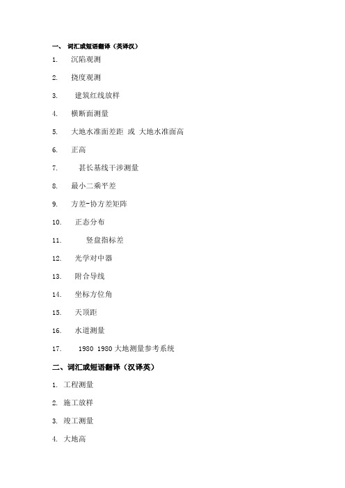
一、词汇或短语翻译(英译汉)1. 沉陷观测2. 挠度观测3. 建筑红线放样4. 横断面测量5. 大地水准面差距或大地水准面高6. 正高7. 甚长基线干涉测量8. 最小二乘平差9. 方差-协方差矩阵10. 正态分布11. 竖盘指标差12. 光学对中器13. 附合导线14. 坐标方位角15. 天顶距16. 水道测量17. 1980 1980大地测量参考系统二、词汇或短语翻译(汉译英)1. 工程测量2. 施工放样3. 竣工测量4. 大地高5. 参考椭球参考椭球6. 卫星激光测距 ()7. 重力场8. 测量平差9. 多余观测10. 点位中误差 a11. 粗差检验12. 自动目标识别 ()13. 几何水准测量14. 水准尺15. 平面控制网16. 控制测量17. 地籍测量三、句子翻译(英译汉)1. , , .测量是测定地面上各点的相对位置,以便根据它们之间正确的水平或竖直关系,按比例展示出天然地物和人工地物的一种技术。
2. , , , .在进行高程测量的一般程序中,比如水准测量中保持前后视距相等,自动考虑和补偿了地球曲率和大气折光的影响,基于曲面得到的高程仍然是可靠的,不需要测量员对数据进行进一步的处理。
3. . . ,, .这种类型的测量考虑到地球曲率的影响,被称为大地测量。
这种类型的测量的特点是区域广、基线长,用来测定控制点的精确位置。
在大地测量中,测站之间距离长,需要使用比平面测量中更精密的仪器和测量方法。
4. , , .两点之间距离可以是水平的,倾斜的或垂直的。
. 水平距离和倾斜距离测量有多种方法,取决于测量的精度要求。
5. , a . , , .电子测距仪的问世给测量程序带来一场深刻的革命,导致了重点与技术的改变。
不管地形情况如何,距离测量现在都变得简单、迅速,而且有很高的精度。
5. . .更集成的电子测距仪除测量斜距外,同时还具备测量水平角、竖直角和天顶距的功能。
这类仪器一般称之为全站仪。
6. , .控制网的类型从小区域的、简单的、便宜的到大范围的、复杂的、价格昂贵的不等。
测绘工程专业英语考试重点(包括单词)

测绘工程专业英语考试重点Geomatic测绘学Geosciences地球科学Geodesy大地测量学Cadastral surveying地籍测量Geodetic surveying 大地测量Marine survey 海洋测量Geological survey 地质测量Control survey 控制测量Horizontal survey 水平测量Vertical survey 高程测量Topographic survey 地形测量Tacheometry 视距测量Contour等高线Chart图表Fieldwork外业Officework内业Elevation高程Basic point 基准点Benchmark 水准基点Stations 测站Geoid 水准面Vertical垂直Theodolite经纬仪Monumentation埋石Latitude纬度Longitude经度Prime meridian 本初子午线Gravity field 重力场Curvature 曲率Fixed error 固定误差Proportionnal error 比例误差Multiplication constant 乘常数Angle 角度Zenith distance 天顶距Circle 度盘Azimuth方位角Triangulation 三角测量Traversing 导线测量Triangulateration 边角测量Control network 控制网Forward intersection 前方交会Resection 后方交会Side intersection 侧方交会Traverse angle 导线折角Open traverse 支导线Close traverse 闭合导线Close loop traverse闭合环导线Connecting traverse 符合导线Coordinate increment坐标增量Trigonometric leveling 三高程测量Horizontal 水平距Rod plate 尺垫Coordinates 坐标系Geodetic 大地基准Origin 原点Parameter 参数Map projection 地图投影Equidistant projection等距投影Equivalent projection 等积投影Orthographic projection 正射投影Differential correction 差分改正Real time kinematicRTK实动定位Cartograph制图学Raster 栅格光栅Embed 嵌入Resolution 分辨率Data classification 数据分类Topological relationship 拓扑关系aerial photogrammetry 航空摄测量Remote sensing 遥感InSAR干涉合成孔径雷达Prism 棱镜Blunder/gross error 粗差Index error 指标差Standard deviation 标准差Mean square error中误差Calibrate 校准Normal equation 法方程Space segment 空间部分--------------------------settlement observation 沉陷观测deflection observation 挠度观测property line survey 建筑红线放样cross-section survey 横断面测量geoid undulation 大地水准面差距orthometric height 正高very long baseline interferometry甚长基线干涉测量connecting traverse 附合导线zenith distance 天顶距hydrographic survey 水道测量工程测量engineering survey施工放样construction layout orsetting-out survey竣工测量as-built survey参考椭球reference ellipsoid 参考卫星激光测距satellite laserranging(SLR)重力场gravity field测量平差adjustment ofobservation or survey adjustment多余观测redundant observation点位中误差mean square error ofa point粗差检验gross error detection自动目标识别automatic targetrecognition(ATR水准尺level lod平面控制网horizontal controlnetwork地籍测量cadastral surveying orproperty survey1. Surveying is the art of making such measurements of the relative positions of points on the surface of the earth that, on drawing them to scale, natural and artificial features may be exhibited in their correct horizontal or vertical relationships.测量是测定地面上各点的相对位置,以便根据它们之间正确的水平或竖直关系,按比例展示出天然地物和人工地物的一种技术。
测绘工程专业英语(中国地质大学长城学院)

一、名词解释:1、Surveying (测量学)is the art of making such measurements of the relative positions of points on the surface of Earth that,on drawing them to scale natural and artificial features may be exhibited in their correct horizontal or vertical relationships.2、Plane surveying (平面测量)is of wide scope and utility,and its methods are e mployed in the vast majorit y of surveys undertaken for various purposes,such as en gineering ,architectural,legal,c ommercial,scientific,geograph ical,exploratory,military,and n avigational.3、Geodetic surveys(大地测量)are usually of a nati onal character,occasionally w orks of international coopera tion,and they are undertaken as basis for the production of accurate maps of wide areas.4、Leveling(水准测量) is t he general term applied to a ny of the various processes by which elevations of point s or differences in elevation are determined.5、The theodolite (经纬仪)is an instrument designed for the measurement of hori zontal and vertical angles.It is the most precise instrume nt available for such observ ations,and is of wide applica bility in surveying.6、A traverse(导线)is a series of consecutive lines whose lengths and directions have been determined from field measurements7、Traversing(导线测量),the act of establishing traverse stations and making the ne cessary measurements,is one of the most basic and wid ely practiced means of deter mining the relative locations of points.8、Azimuths(方位角)are measured clockwise from th e north end of the meridian through the angle points. 9、Topographic surveys(地形测量)are made to deter mine the configuration (relie f) of the earth’s surface and to locate natural and cultur al features on it.10、A topographic map(地形图)is a large scale repres entation of a portion of theEarth’s showing culture, relief, hydrography, and perhaps vegetation.11、Systematic-Error(系统误差):These-errors conformto mathematical and physical laws.Their magnitude maybe constant or variable depending on conditions.12、Radom error(偶然误差):These are errors that remain after mistakes and systematic errors have been eliminated.13、Precision(精度)refers to the degree of refinementor consistency of a group of measurements.14、Accuracy(准确度)which denotes the absolute nearness of measured quantities to their true values.二、填空1、The metal case is attached to some part of the instrument in such a way as topermit some (adjustment) of the position.2、Transits,are instrumentswhich ..... Along the verticalplane (altitude) as well asthe horizontal plane (azimuth).3、These instruments are (tripods),plane tables,(level rods),chains,and (tapes).4、As can be observed ,EDM systems are made up ofthree components-(a transmitter),(a reflector),and (a receiver).5、....the telescope must becapable of rotation about a(horizontal axis),for measurement of horizonal angles,the instrument must be rotatedabout a (vertical axis).6、There must be an (indexmark) on the rotating part,placed so that readings canbe taken against it on the(graduated circle).7、.....the observer operatesa setting device to obtain a(mean reading) free from(eccentricity error).8、If the (plumb bob) is not over the point,the (centering screw) can be loosenedand the.......9、These notes include directions.....stations with (fourdifferent positions).Two readings were taken on each position (one with the telescope normal or direct and onewith the instrument (reversed or plunged)).10、The line is determinedby a telescope with the usual components consisting of(object glass),(focusing arrangement),(diaphragm withcross-lines), and (eye-piece).11、A level fitted with (horizontal circle) and (stadia lines) can be used to make acomplete (three-dimensional) survey of a limited area round the instrument.12、Levels are used to obtain the direct measurement of (height differences)between two points.13、Which transmit either (modulated laser) or (infrared light) having wavelengths within or slightly beyondthe ......14、Which transmits (microwaves) with (frequencies) in the range of 3 to 35GHZcorresponding to wavelength of about 1.0 to 8.6 mm.15、The methods used in measuring angles or directionsof traverse lines vary,and include (compass bearings),(interior angles),(deflection angles),(angles to the right),(azimuths).16、The instrument is oriented at each station by (backsighting) on the previous point with (the back bearingset) on the plates.17、(Electronic devices) and (taping) are used most often and provide the highestorder of accuracy.18、On construction work,(allowable limits of closure)depend on the use and extent of the traverse and typeof project.Bright location, for example ,demands a highdegree of precision.19、Vertical control is provided by bench marks in or near the tract to be surveyed.It becomes the foundation for correctly portraying reliefon a map,A (vertical control net)is established by (lines of levels)starting fromand closing on bench marks.三、翻译:1、It is convenient to considerthat a bubble tube has anaxis,which may be taken as astraight line parallel to the freesurface of the liquid when thebubble is in the centralposition determined by thegraduation marks.当气泡处于分划线所确定的中心位置时,我们可以很容易想像水准管有一个轴,这个轴可以看作是一条与液体的自由表面平行的直线。
测绘专业英语1UNIT 7

surveyor guides the person holding the prism along the line of computed direction until the distance to the point to be located agrees with the computed distance. All displayed outputs can also be recorded or stored in electronic field book for further calculations in computer. Total stations allow the measurement of many points on a surface being observed within a very short time range. Robotic Total Station A late 1980s adaption of the total station is the addition of servo motors to drive both the horizontal and the vertical motions of these instruments. For all the complex electronics inside a robotic total station, the motion is still provided by simple servo motors with a reduction gear system. The end result must be lightweight, durable and fast and have sub-second positioning accuracy. When those total stations have been designed with automatic target recognition (ATR) function, they allow
高二英语地质勘探单选题40题

高二英语地质勘探单选题40题1.Geologists use _____ to study the structure of the earth.A.telescopesB.microscopesC.satellitesD.seismographs答案:D。
本题考查地质学家使用的工具名称。
选项A“telescopes”是望远镜,用于观测天体等;选项B“microscopes”是显微镜,用于观察微小物体;选项C“satellites”是卫星,主要用于通讯、气象等领域;选项D“seismographs”是地震仪,地质学家使用地震仪来研究地球结构。
2.During geological exploration, they often _____ rocks to analyze their composition.A.collectB.holdC.touchD.throw答案:A。
本题考查在地质勘探中对岩石的动作。
选项B“hold”是拿着;选项C“touch”是触摸;选项D“throw”是扔;选项A“collect”是收集,在地质勘探中,地质学家经常收集岩石来分析其成分。
3.The _____ is an important tool for measuring the thickness of rock layers.A.rulerB.tape measureC.sonarD.sediment core答案:B。
本题考查测量岩石层厚度的工具。
选项A“ruler”是尺子,一般用于测量较小物体的长度;选项C“sonar”是声纳,主要用于水下探测;选项D“sediment core”是沉积物岩心;选项B“tape measure”是卷尺,可以用来测量岩石层的厚度。
4.Geologists _____ different methods to determine the age of rocks.eB.makeC.doD.have答案:A。
- 1、下载文档前请自行甄别文档内容的完整性,平台不提供额外的编辑、内容补充、找答案等附加服务。
- 2、"仅部分预览"的文档,不可在线预览部分如存在完整性等问题,可反馈申请退款(可完整预览的文档不适用该条件!)。
- 3、如文档侵犯您的权益,请联系客服反馈,我们会尽快为您处理(人工客服工作时间:9:00-18:30)。
滁州学院2010 /2011学年度第2学期期末考试试卷测绘工程专业(本科) 2008 级《测绘专业英语》试卷(时间90分钟)一、 词汇或短语翻译(英译汉)(每小题1分,共20分) 1. settlement observation 沉陷观测2. deflection observation 挠度观测3. property line survey 建筑红线放样4. cross-section survey 横断面测量5. geoid undulation 大地水准面差距 或 大地水准面高6. orthometric height 正高7. very long baseline interferometry 甚长基线干涉测量 8. least-squares adjustment 最小二乘平差9. variance-covariance matrix 方差-协方差矩阵 10. normal distribution 正态分布11. index error of vertical circle 竖盘指标差 12. optical plummet 光学对中器 13. connecting traverse 附合导线 14. grid bearing 坐标方位角 15. zenith distance 天顶距16. hydrographic survey 水道测量17. Geodetic Reference System 1980 1980大地测量参考系统二、词汇或短语翻译(汉译英)(每小题1分,共20分)1. 工程测量 engineering survey2. 施工放样 construction layout or setting-out survey3. 竣工测量 as-built survey4. 大地高 geodetic survey5. 参考椭球 reference ellipsoid 参考椭球6. 卫星激光测距 satellite laser ranging(SLR)7. 重力场 gravity field8. 测量平差 adjustment of observation or survey adjustment 9. 多余观测 redundant observation10. 点位中误差 mean square error of a point11. 粗差检验 gross error detection12. 自动目标识别 automatic target recognition(ATR) 13. 几何水准测量 direct leveling or spirit leveling 14. 水准尺 level rod15. 平面控制网 horizontal control network 16. 控制测量 control survey17. 地籍测量 cadastral surveying or property survey三、句子翻译(每小题×分,共×分)1. Surveying is the art of making such measurements of the relative positions of points on the surface of the earth that, on drawing them to scale, natural and artificial features may be exhibited in their correct horizontal or vertical relationships.测量是测定地面上各点的相对位置,以便根据它们之间正确的水平或竖直关系,按比例展示出天然地物和人工地物的一种技术。
2. The ordinary procedure in determining elevations, such as balancing backsight and foresight distance in differential leveling, automatically takes into account the curvature of the earth and compensates for earth curvature and refraction, and elevations referred to the curved surface of reference are secured without extra effort by the surveyor.在进行高程测量的一般程序中,比如水准测量中保持前后视距相等,自动考虑和补偿了地球曲率和大气折光的影响,基于曲面得到的高程仍然是可靠的,不需要测量员对数据进行进一步的处理。
3. The type of surveying that takes that takes into account the true shape of the earth is called geodetic surveying. This type of survey of survey is suited for large areas and long lines and is used to find the precise location of basic points needed for establishing control for other surveys. In geodetic surveying ,the stations are normally long distances apart, and more precise instruments and surveying methods are required for this type of surveying than for plane surveying.这种类型的测量考虑到地球曲率的影响,被称为大地测量。
这种类型的测量的特点是区域广、基线长,用来测定控制点的精确位置。
在大地测量中,测站之间距离长,需要使用比平面测量中更精密的仪器和测量方法。
4. Distance between two points can be horizontal, slope, or vertical. 两点之间距离可以是水平的,倾斜的或垂直的。
Horizontal and slope distances can be measured with lots of techniques of measurement depending on the desired quality of the result. 水平距离和倾斜距离测量有多种方法,取决于测量的精度要求。
5. The advent of EDM instrument has completely revolutionized all surveying procedures, resulting in a change of emphasis and techniques. Distance can now be measured easily, quickly and with great accuracy, regardless of terrain conditions.电子测距仪的问世给测量程序带来一场深刻的革命,导致了重点与技术的改变。
不管地专业: 年级/班级: 姓名: 学号:装 订 线 内 不 要 答 题形情况如何,距离测量现在都变得简单、迅速,而且有很高的精度。
5. More complete EDM instruments also have the capacity of measuring horizontal and vertical or zenith angles as well as the slope distance. These instruments referred to as total station instruments.更集成的电子测距仪除测量斜距外,同时还具备测量水平角、竖直角和天顶距的功能。
这类仪器一般称之为全站仪。
6. Control networks range from small, simple and inexpensive to large and complex and very expensive to establish.控制网的类型从小区域的、简单的、便宜的到大范围的、复杂的、价格昂贵的不等。
7. The method of surveying called triangulation is based on the trigonometric proposition that if one side and three angles of a triangle are known, the remaining sides can be computed by the law of sines.这种测量方法称为三角测量,是基于如下三角形定理:如果三角形的一条边长和三个内角已知,那么其余的边长可以根据正弦定理计算得到。
Furthermore, if the direction of one side is known, the direction of the remaining sides can be determined. And the coordinates of unknown points can be computed by application of trigonometry.此外,如果其中一条边的方向已知,其余边的方向就可以确定。
故未知点的坐标可以由三角公式计算得到。
8. Since the advent of EDM equipment, traversing has emerged as the most popular method to establish control networks such as basic area control, mapping, control of hydrographic surveys and construction projects.自从电子测距仪问世,导线测量已成为建立控制网最常用的方法,比如基本的区域控制,制图,水文测量和建筑工程的控制等。
9. In engineering surveying, it is ideal way to surveys and dimensional control of route-type projects such as highway, railroad, and pipeline construction.在工程测量中,导线测量是线状工程的测量和尺寸控制的理想方法,比如公路、铁路、管线施工等。