MCM ICM 数学建模历年优秀论文 洪水 大坝模型
数学建模-抗洪救灾规划

摘要问题一考虑到水流由地势高流向地势低,将原始数据进行处理,并建立0-1变量来评定两个村庄间能否建立泄洪河道。
再由修建泄洪河道的费用计算式,分析影响费用大小的两大制约因素承载泄洪量和泄洪河道长度,可得两种分别以泄洪量大河道短和泄洪量小河道长为主的修建河道的方案,综合考量这两个因素,确立目标函数的约束条件,建立非线性规划,运用LINGO软件对模型进行优化求解。
问题二中,主要应用了马尔科夫链的相关定义和性质建立数学模型,运用MATLAB编程得出运行结果。
模型中对等可能概率与非等可能概率进行不同的求解,给出了相关通用方的模型。
对运算后得到的稳定性进行判定与分析。
问题三考虑到修建泄洪水道可能会导致下游村庄承载泄洪量过高,而致使修建难度提高,维修不易等因素,我们提出可以修建水库。
这样不仅缓解了下游的泄洪水道压力,而且水库具有滞洪、蓄洪,调节水源的作用,可以有效的减少洪涝灾害带来的损失。
一.问题重述某个偏远贫困乡,地处山区,一旦遇到暴雨,经常发生洪涝灾害。
以往下雨时,完全是依靠天然河流进行泄洪。
2010年入夏以来,由于史无前例的连日大雨侵袭,加上这些天然河流泄洪不畅,造成大面积水灾,不仅夏粮颗粒无收,而且严重危害到当地群众的生命财产安全。
为此,乡政府打算立即着手解决防汛水利设施建设问题。
从长远考虑,可以通过修建新泄洪河道的办法把洪水引出到主干河流。
经测算,修建新泄洪河道的费用为LQP51.066.0(万元),其中Q表示新泄洪河道的可泄洪量(万立方米/小时),L表示新泄洪河道的长度(公里)。
该乡共有10个村,分别标记为①—⑩,下图给出了它们大致的相对地理位置,海拔高度总体上呈自西向东逐渐降低的态势。
①②③④⑤⑥⑦⑧⑨⑩其中村⑧距离主干河流最近,且海拔高度最低。
乡政府打算拟定一个修建在各村之间互通的新泄洪河道网络计划,将洪水先通过新泄洪河道引入村⑧后,再经村⑧引出到主干河流。
要求完成之后,每个村通过新泄洪河道能够达到可泄洪量100万立方米/小时以上的泄洪能力。
2008年研究生数学建模竞赛优秀论文选-《唐家山堰塞湖泄洪问题的研究》-33页
全国第五届研究生数学建模竞赛题目唐家山堰塞湖泄洪问题的研究摘要:本文以唐家山堰塞湖为研究对象,参考权威报道的数据内容及来源于DEM模型的遥感影像,探讨了堰塞湖演化、溃坝、洪波传播等方面的问题。
针对第一个问题,先依据所采集的实际样本值回归得到库容回归模型,接着根据堰塞湖其形成机理建立库容一般模型,由于条件受限无法获取地质地形数据,因此修正了一般模型。
最后依据库容的回归模型和修正模型分别建立以降雨量来预测堰塞湖水位日上升高度的模型,并以此预测5月25日至6月12日的水位日上升高度(见表3.1)。
通过对比两个结果发现,库容修正模型较其回归模型的实用性和稳定性更强。
针对第二个问题,在第一问的库容模型的基础上,依据经典的溃坝洪水预报模型—DAMBRK模型思想分别建立了溃口形态模型和水体下泄模型,给出了溃口形态、溃口流量、堰塞湖水位等物理量的数学描述。
同时根据实际情况,模拟了堰塞湖漫顶逐渐溃的过程,溃坝历时20584秒,并且给出了溃口形态、溃口流量、堰塞湖水位随时间的变化关系(见图4.3~4.6)。
针对第三个问题,在第二问的溃坝模型的基础上,通过假设漫溢性洪水在瞬时达到稳态,简化经典动力学洪水演进模型,建立结合动力学模型和基于DEM 网格模型的洪水淹没模型,并采用种子蔓延算法计算出洪水淹没区域。
运用该模型对唐家山堰塞湖出现三分之一蓄水下泄的情形进行了模拟,对洪水淹没区域的过程进行可视化演示(见图5.6),并且计算出洪水到达人口密集区域的时间(见表5.1),最后给出各区域的人员撤离方案。
最后,依据前三个问题所建立的模型,分析在抗震救灾中采取的应对策略,指出其适用性和局限性,并对如何应对地震后次生ft地灾害提出一些建设性意见。
关键词:多项式回归DAMBRK DEM 网格模型参赛队号1048603 参赛密码(由组委会填写)1 问题提出堰塞湖是一种自然的地貌现象,主要是在一定的地质和地貌条件下,由地震活动、冰碛物或火ft熔岩流等原因引起崩塌、滑坡、泥石流等堵截ft谷、河谷或河床后贮水而形成的湖泊。
基于MIKE FLOOD的城区溃坝洪水模拟研究
基于MIKE FLOOD的城区溃坝洪水模拟研究王欣;王玮琦;黄国如【摘要】The safety of dam not only affects the benefit of the project,but also relates closely to the safety of people's life and property.Dam-break flood simulation can evaluate the impacts of dam-break,and it is of great significance to the making of emergency plans so as to control flood and reduce disasters.Researches are carried out on the dam-break flood developing process in the downstream of the Minzhi reservoir based on the MIKE FLOOD model,which couples MIKE 11 and MIKE 21.By adopting two methods,a sudden dam-break method (for sudden partial dam-break as well as sudden full dam-break) and a gradual dam-breakmethod,simulations of the flow graphs at the breach dam under four operating situations and the flood developing process in the downstream are respectively made in this study.The research results show that the peak flow of the sudden dam-break is larger at the beginning of the dam break,and the gradual dam-break peak flow is relatively small when the deformation of seepage failure develops to the upper part of the dam.And then,as the water level in the reservoir falls gradually,the flow discharge becomes smaller,until the reservoir is emptied.The dam-break flood has a greater destructive power against the upstream area of the Hengling village,where the submerged depth is larger.The flood velocity is up to 5 m/s in the residential and commercial areas of the middle reach of the Minzhi River.The flood has a certain damage to the buildings.The left sideof the Xiangnan village is low-lying,the flooding is the most serious,and it still has a waterlogging depth of 3 m after the flood subsidence.%大坝安全不仅影响工程效益,还影响人民的生命和财产安全,溃坝洪水模拟可以对水库大坝的失事影响做出评估,对制定应急预案和防洪减灾具有重要意义.以深圳市龙华新区民治水库及下游片区为研究对象,基于MIKE FLOOD将MIKE 11模型和MIKE21模型进行动态耦合,对溃坝洪水在下游的演进过程进行仿真模拟.模型采用瞬间溃(瞬间部分溃和瞬间全溃)以及逐渐溃两种溃决方式,分别模拟4种工况下的溃口流量过程线以及下游洪水演进过程.结果表明:瞬间溃的洪峰流量较大,出现在溃坝开始时刻,而逐渐溃的洪峰流量相对较小,出现在渗透破坏变形发展至上部坝体坍塌时刻,之后均随库区水位逐渐降低,下泄流量变小,直至库区水体排空.溃坝洪水对上游地区横岭村附近破坏较大,淹没水深较深.民治河中游段居民和商业区附近洪水流速接近5 m/s,对建筑物有一定破坏力,左侧向南村地势较低,淹没情况最为严重,并且在洪水消退后仍有3 m左右积水.民治河下游地区在洪水消退后也有少量积水.【期刊名称】《水利水运工程学报》【年(卷),期】2017(000)005【总页数】7页(P67-73)【关键词】溃坝洪水;MIKE FLOOD;数值模拟;淹没水深;淹没范围【作者】王欣;王玮琦;黄国如【作者单位】华南理工大学土木与交通学院,广东广州510640;华南理工大学土木与交通学院,广东广州510640;华南理工大学土木与交通学院,广东广州510640;华南理工大学亚热带建筑科学国家重点实验室,广东广州510640【正文语种】中文【中图分类】TV122+.4水库大坝是人类历史上重要的水工建筑物,在兴利和调蓄洪水等方面发挥着不可替代的作用,同时对区域内国民经济发展也承担着重要角色[1]。
数学建模优秀论文灾情巡视路线的数学模型

精心整理灾情巡视路线的数学模型摘要本文解决的是灾情巡视路线的设计问题。
由于路线图可看成网络图因此此问题可转化为在给定的加权网络图中寻找从给定点O出发行遍所有顶点至少一次再回到点O使得总权(路程或时间)最小的问题。
然后针对具体问题,采用一些启发式算法,建立模型进行求解。
对于问题一:基于设计分三组巡视时使总路程最短且各组尽可能均衡的巡视路线的要求我们采用Dijkstra算法,通过对初始圈进行二边逐次修正,处理三组的巡视路线长度,用lingo软件求解出较优方案。
定义分组的均衡度系数a检验分组均衡度,在均衡度为a=0.0751时得到分三组(路)巡视时,总路程最短且各组尽可能均衡的巡视路线见附表1。
1.问题重述1.1问题背景今年夏天某县遭受水灾。
为考察灾情、组织自救,县领导决定,带领有关部门负责人到全县各乡(镇)、村巡视。
巡视路线指从县政府所在地出发,走遍各乡(镇)、村,又回到县政府所在地的路线。
附录一中给出了该县的乡(镇)、村公路网示意图,公路边的数字为该路段的公里数。
1.2本文需解决的问题问题一:若分三组(路)巡视,试设计总路程最短且各组尽可能均衡的巡视路线。
问题二:假定巡视人员在各乡(镇)停留时间T=2小时,在各村停留时间t=1小时,汽车行驶速度V=35公里/小时。
要在24小时内完成巡视,至少应分几组;给出这种分组下你认为最佳的巡视路线。
2.12.2路线。
因此问题就转化为一个图论问题,即在给定的加权网络图中,寻找从给定点O出发,行遍所有顶点至少一次再回到O点,使得总权(路程或时间)最小。
此即多个推销员的最佳推销员回路问题。
基于以上分析,运用图论知识和图论软件包进行求解,再利用均衡度分析对得到的分组路线进行微调,均衡度越小表示路线越均衡,微调后即可得到相对较优的分组路线。
可认为这样设计的分组方法和巡回路线能使总路线近似最短。
针对问题二:在问题一的基础上添加了巡视组在各乡镇停留时间T=2小时,在各村停留时间t=1小时,汽车行驶速度V=35公里/小时等条件,要求在24小时内完成巡视的最少分组数以及相应的最佳巡视路线。
基于Mike模型珲春河洪水演进数值模拟
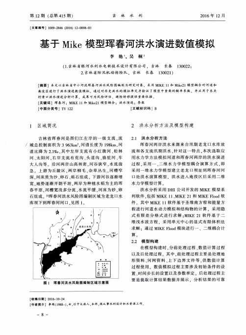
春平 原 , 河 槽 宽浅 多分 流 , 水 流平 缓 , 河床 为 砂 , 卵 石组 成 … 珲 春河洪 水风 险 图编制 区域 为 老龙 口水
库坝 下到 珲春 河河 口. 见图 l
洪 水 分析 采用 D H I 公 司开发 的 MI K E模 型 系
村 溃 口洪水 演进 分 析 计 算 .成 果 可 为风 险评 估 、避 险 转 移提 供 重要 依 据 。
[ 关 键 词 ] 珲 春 河 ;MI K E 1 1和 Mi k e 2 1 模 型耦 合 ; 洪水 演进 ;参 数 [ 中图 分 类 号 ]T V 1 2 2 [ 文献 标 识 码 ]B
2 . 吉林 省 防汛机 动抢 险 队 ,吉林 长春 1 3 0 0 2 1 )
[ 摘 要 ]本 文 以 吉 林 省 中 小河 流 珲 春 河 洪 水 风 险 图 编 制 为研 究 对 象 ,采 用 MI K E 1 1和 Mi k e 2 1 模 型 耦 合 对 河道 和 淹 没 区进 行 了 洪水 演 进 数 值模 拟 。通 过 对 历 史洪 水的 模 拟 率 定 并验 证 了模 型 中重 要 的 糙 率 参 数 , 并 应 用 于 东关
列软 件 , 包 括 MI K E 1 1 、 MI K E 2 1和 MI K E F l o o d软
件 其 中 MI K E l l 软件 基 于圣 维南 方 程 和能 量 方 程进 行 河道 水 动 力模 拟 和结 构 物 的计 算 .采 用 隐 式 有限差 波方 程 .采用 单 元 中心 的 显式 有 限体 积 法 求 解 :通 过 MI K E F l o o d模 块进 行一 、二 维耦 合 计 算。
与封堵溃口有关的重物落水后运动过程的数学建模

全国第七届研究生数学建模竞赛题 目 与封堵溃口有关的重物落水后运动过程的数学建模摘 要:我国经常发生洪水,溃坝溃堤进而引发泥石流灾害造成国家和人民生命财产的严重损失。
对封堵溃口的研究刻不容缓。
本文在对流水中物体进行受力分析的基础上完成了以下工作:1、找出了影响重物在水中运动的关键因素:水文状况,包括水流速度、水深、水流密度;物体的入水状况,入水姿态、物体的密度、物体的形状等等;2、通过合理假设,建立了流水中物体运动的数学模型: 垂直方向:2()()2y y l w v t dv t C A Vg mg m dt ρρ+-= 水平方向:20(())()2x x d d v t v dv t C A m dtρ-= 利用半时间步长中心差分的方法对建立的不同模型进行了求解;从而比较好的解决了单物体以及简单情况下两物体在水中运动轨迹求解的问题;3、阐述了模型中参数C l 与C d 的确定过程,同时为了提高模型的适用性,对物体入水过程进行了深入的探讨,修正了试验数据,并据此对模型进行了检验,验证了模型的有效性以及改进模型的优越性;4、针对试验中的不足,提出了使用光感应器件以及传感器来获取试验数据的方法,提高了测量数据的可靠性和实时性;5、使用MATLAB (见附件3)平台开发了针对箱体在水中运动规律可视化的软件。
6、找出了试验所满足的相似准则提高了模型解决实际问题的效率。
目录题目与封堵溃口有关的重物落水后运动过程的数学建模 (1)1.问题的重述 (3)2.名词、符号说明及基本假设 (4)2.1 名词符号说明 (4)2.2 基本假设 (5)3.问题分析 (5)3.1 物体在空中的自由下落的过程 (6)3.2 物体在水中下沉的过程 (6)3.3 物体的入水过程 (8)4.实体大方砖在流水中运动过程的模型 (9)4.1 大方砖在水中的受力分析 (9)4.2 运动模型I(运动方程)的建立 (10)4.3 C d和C l的确定 (10)4.4 运动方程的求解 (11)5.单个重物以及两个重物连接后在水中运动过程的模型 (14)5.1 对小型试验中物体运动轨迹数据的修正 (14)5.2 为适应不同重物在水中运动的模型建立所需进行的修正 (15)5.3 单个重物在流水中运动模型II的建立 (16)5.4 两个重物水中运动模型的建立 (19)5.5 模型I和模型II的比较与分析 (20)5.6 通过模型的建立我们可以得到以下的结果: (22)6.对模型误差的分析以及有效性验证 (26)6.1 模型的误差分析 (27)6.2 模型有效性的验证 (27)7.相似准则研究与试验、模型的应用 (31)7.1 相似准则概述 (31)7.2 本模拟试验中所满足的相似准则 (31)7.3模型应用 (32)8.结论与展望 (35)1.问题的重述与封堵溃口有关的重物落水后运动过程的数学建模我国经常发生洪水,溃坝溃堤进而引发泥石流灾害造成国家和人民生命财产的严重损失。
2005年美国大学生数学建模大赛赛题
2005 MCM ProblemsPROBLEM A: Flood PlanningLake Murray in central South Carolina is formed by a large earthen dam, which was completed in 1930 for power production. Model the flooding downstream in the event there is a catastrophic earthquake that breaches the dam.Two particular questions:Rawls Creek is a year-round stream that flows into the Saluda River a short distance downriver from the dam. How much flooding will occur in Rawls Creek from a dam failure, and how far back will it extend?Could the flood be so massive downstream that water would reach up to the S.C. State Capitol Building, which is on a hill overlooking the Congaree River?PROBLEM B: TollboothsHeavily-traveled toll roads such as the Garden State Parkway , Interstate 95, and so forth, are multi-lane divided highways that are interrupted at intervals by toll plazas. Because collecting tolls is usually unpopular, it is desirable to minimize motorist annoyance by limiting the amount of traffic disruption caused by the toll plazas. Commonly, a much larger number of tollbooths is provided than the number of travel lanes entering the toll plaza. Upon entering the toll plaza, the flow of vehicles fans out to the larger number of tollbooths, and when leaving the toll plaza, the flow of vehicles is required to squeeze back down to a number of travel lanes equal to the number of travel lanes before the toll plaza. Consequently, when traffic is heavy, congestion increases upon departure from the toll plaza. When traffic is very heavy, congestion also builds at the entry to the toll plaza because of the time required for each vehicle to pay the toll.Make a model to help you determine the optimal number of tollbooths to deploy in a barrier-toll plaza. Explicitly consider the scenario where there is exactly one tollbooth per incoming travel lane. Under what conditions is this more or less effective than the current practice? Note that the definition of "optimal" is up to you to determine.2005 ICM ProblemPROBLEM C: Nonrenewable ResourcesSelect a vital nonrenewable or exhaustible resource (water, mineral, energy, food, etc.) for which your team can find appropriate world-wide historic data on its endowment, discovery, annual consumption, and price.The modeling tasks are:ing the endowment, discoveries, and consumption data, model thedepletion or degradation of the commodity over a long horizon using resource modeling principles.2.Adjust the model to account for future economic, demographic, politicaland environmental factors. Be sure to reveal the details of your model, provide visualizations of the model’s output, and explain limitations of the model.3.Create a fair, practical "harvesting/management" policy that may includeeconomic incentives or disincentives, which sustain the usage over a long period of time while avoiding severe disruption of consumption, degradation or rapid exhaustion of the resource.4.Develop a "security" policy that protects the resource against theft,misuse, disruption, and unnecessary degradation or destruction of the resource. Other issues that may need to be addressed are political and security management alternatives associated with these policies.5.Develop policies to control any short- or long-term "environmentaleffects" of the harvesting. Be sure to include issues such as pollutants, increased susceptibility to natural disasters, waste handling and storage, and other factors you deem appropriate.pare this resource with any other alternatives for its purpose. Whatnew science or technologies could be developed to mitigate the use and potential exhaustion of this resource? Develop a research policy to advance these new areas.。
数学建模 美赛特等奖论文(中文版)分析溃坝:针对南卡罗来纳州大坝坍塌建立模型
分析溃坝:针对南卡罗来纳州大坝坍塌建立模型 摘要萨鲁达大坝建立在卡罗莱纳州的墨累湖与萨鲁达河之间,如果发生地震大坝就会坍塌。
本文通过建立模型来分析以下四种大坝决口时水的流量以及洪水泛滥时水的流量:● 大坝的绝大部分被瞬间侵蚀看成是大坝瞬间彻底坍塌;● 大坝的绝大部分被缓慢侵蚀看成是大坝延期彻底坍塌;● 管涌就是先形成一个小孔,最终形成一个裂口;● 溢出就是大坝被侵蚀后,形成一个梯形的裂口。
本文建立了两个模型来描述下游洪水的泛滥情况。
两个模型都采用离散网格的方法,将一个地区看成是一个网格,每个网格都包含洪水的深度和体积。
复力模型运用了网格的速度、重力以及邻近网格的压力来模拟水流。
下坡模型假定水流速度与邻近网格间水位高度的成正比例。
下坡模型是高效率的、直观的、灵活的,可以适用于已知海拔的任何地区。
它的两个参数稳定并限制了水流,但该模型的预测很少依赖于它们的静态值。
对于萨鲁达溃坝,洪水总面积为25.106km ;它还没有到达国会大厦。
罗威克里克的洪水向上游延伸了km 4.4,覆盖面积达24.26.1km -变量及假设表1说明了用来描述和模拟模型的变量,表2列出了模拟程序中的参数。
表 1模型中的变量.变量 定义溃坝时的水流量速率1TF Q 瞬间彻底坍塌2TF Q 延期彻底坍塌PIPE Q 管涌OT Q 溢出peak Q 最大流速溃坝时水流出到停止所用时间1TF t 瞬间彻底坍塌2TF t 延期彻底坍塌PIPE t 管涌OT t 溢出V ∆ 溃坝后从墨累湖里流出的水的总体积Lm Vol 墨累湖的原来体积LM Area 墨累湖的原来面积breach d 从裂口到坝顶距离breach t 从裂口开始到溃坝形成的时间 近似圆锥的墨累湖的侧面一般假设● 正常水位是在溃坝前的湖水位置。
● 河道中的水流不随季节变化而变动。
● 墨累湖里的水的容积可以看作为一个正圆锥(图1 )。
表2 模拟程序中的参数 参数 所取值 意义BREACH_TYPE 变量 瞬间彻底坍塌,延期彻底坍,管涌,溢出模型中的一种 T ∆ 0.10 时间不长的长度(s)MIN_DEPTH 0001.0 网格空时的水的深度(m) FINAT T 100000 大坝彻底决口所用时间 b T 3600 溃坝达最大值的时间(s) peak Q 25000 溃坝的最大流速(m 3/s) breach d 30 蓄水池的最初深度(m) LM Volume 910714.2⨯ 墨累湖的总体积(m 3) LM Area 610202⨯ 墨累湖的总面积(m 2)k 504.0 扩散因素 (控制两网格间交换的水的数量) MAX_LOSS_FRAC 25.0 单位网格中水的最大流失量图 1. 水库近似一个正圆锥.大坝假设● 萨鲁达大坝在以下四种方式之一坍塌:-瞬间彻底坍塌,-延期彻底坍塌,-管涌,-溢出。
- 1、下载文档前请自行甄别文档内容的完整性,平台不提供额外的编辑、内容补充、找答案等附加服务。
- 2、"仅部分预览"的文档,不可在线预览部分如存在完整性等问题,可反馈申请退款(可完整预览的文档不适用该条件!)。
- 3、如文档侵犯您的权益,请联系客服反馈,我们会尽快为您处理(人工客服工作时间:9:00-18:30)。
230 The UMAP Journal 26.3 (2005)
Geological Survey 1997; 1998] and the frequency of small earthquakes in the area led authorities to consider the consequences of such a disaster.
Summary
We predict the extent of flooding in the Saluda river if a large earthquake causes the Lake Murray dam to break. In particular, we predict how high the water would be when it reached Columbia and how far the flooding would spread up tributaries of the Saluda like Rawls Creek. We base our model on the Saint-Venant equations for open-channel water flow. We use a discrete version of them to predict the water level along the length of the river. Our model takes into account the width of the floodplain, the slope of the river, the size of the break in the dam, and other factors. We estimate parameters for Lake Murray, its dam, and the Saluda River and calculate the flood results.
-0-A
Figure 1. Topographical map of the Saluda River from the base of Lake Murray to the Congaree River [Topozone 20041.
We lay out our assumptions and set up a submodel of Lake Murray and the Lake Murray dam to simulate the overflow when the dam breaks.
The text of this paper appears on pp. 229-244.
The UMAPJournal26 (3) (2005) 217. @Copyright 2005 by COMAP, Inc. All rights reserved. Permission to make digital or hard copies of part or all of this work for personal or classroom use is granted without fee provided that copies are not made or distributed for profit or commercial advantage and that copies bear this notice. Abstracting with credit is permitted, but copyrights for components of this work owned by others than COMAP must be honored. To copy otherwise, to republish, to post on servers, or to redistribute to lists requires prior permission from COMAP.
The South Carolina State Capitol is safe under even the most extreme circumstances, since it sits on a hill well above the highest possible water level. However, flood waters could still reach 17 m at Columbia and even higher upstream. Buildings in Columbia close to the water would be inundated, but there should be enough warning time for residents to escape. Both our model and local evacuation plans suggest that low-lying areas for miles around would be covered with water.
The UMAPJournal26(3) (2005) 229-244. @Copyright 2005 by COMAP, Inc. All rights reserved. Permission to make digital or hard copies of part or all of this work for personal or classroom use is granted without fee provided that copies are not made or distributed for profit or commercial advantage and that copies bear this notice. Abstracting with credit is permitted, but copyrights for components of this work owned by others than COMAP must be honored. To copy otherwise, to republish, to post on servers, or to redistribute to lists requires prior permission from COMAP.
Introduction
In central South Carolina, a lake is held back by a 75-year-old earthen dam. What would happen if an earthquake breached the dam? The concern is based on an earthquake in 1886 at Charleston that scientists believe measured 7.3 on the Richter Scale [Federal Energy Regulatory Commission 2002]. The location of fault lines almost directly under Lake Murray [SCIway 2000; South Carolina
From Lake Murray to a Dam Slurry 217
From Lake Murray to a Dam Slurry
Clay Hambrick Katie Lewis Lori Thomas
Harvey Mudd CollJon Jacobsen
We then build a model based on the Saint-Venant equations [Moussa and Bocquillon 2000], using conservation of water and momentum to capture the nature of a flood where the main water channel overflows into the surrounding area. We convert the model to a system of difference equations and feed the dam outflow into the beginning of the river.
The South Carolina State Capitol is safe under even the most extreme circumstances, since it sits on a hill well above the highest possible water level. However, flood waters could still reach 17 m at Columbia and even higher upstream. Buildings in Columbia close to the water would be inundated, but there should be enough warning time for residents to escape. Both our model and local evacuation plans suggest that low-lying areas for miles around would be covered with water.