空间插值算法-反距离加权法
ArcGIS中几种空间插值方法
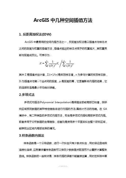
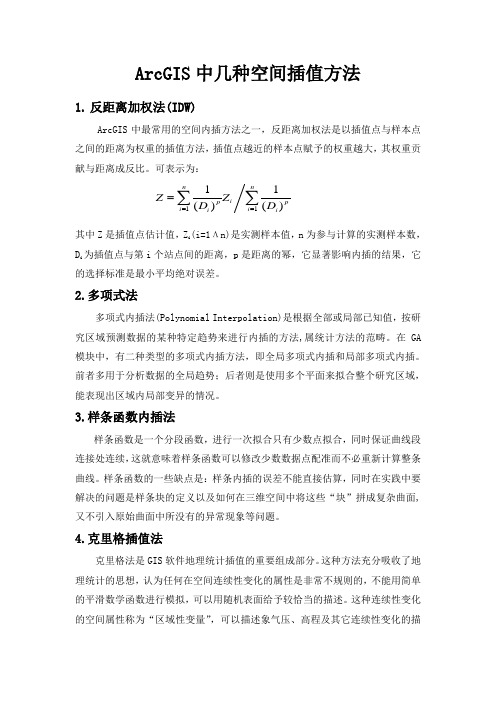
ArcGIS 中几种空间插值方法1. 反距离加权法(IDW)ArcGIS 中最常用的空间内插方法之一,反距离加权法是以插值点与样本点之间的距离为权重的插值方法,插值点越近的样本点赋予的权重越大,其权重贡献与距离成反比。
可表示为:1111()()n nip p i i i i Z Z D D ===∑∑ 其中Z 是插值点估计值,Z i (i=1Λn)是实测样本值,n 为参与计算的实测样本数,D i 为插值点与第i 个站点间的距离,p 是距离的幂,它显著影响内插的结果,它的选择标准是最小平均绝对误差。
2.多项式法多项式内插法(Polynomial Interpolation)是根据全部或局部已知值,按研究区域预测数据的某种特定趋势来进行内插的方法,属统计方法的范畴。
在GA 模块中,有二种类型的多项式内插方法,即全局多项式内插和局部多项式内插。
前者多用于分析数据的全局趋势;后者则是使用多个平面来拟合整个研究区域,能表现出区域内局部变异的情况。
3.样条函数内插法样条函数是一个分段函数,进行一次拟合只有少数点拟合,同时保证曲线段连接处连续,这就意味着样条函数可以修改少数数据点配准而不必重新计算整条曲线。
样条函数的一些缺点是:样条内插的误差不能直接估算,同时在实践中要解决的问题是样条块的定义以及如何在三维空间中将这些“块”拼成复杂曲面,又不引入原始曲面中所没有的异常现象等问题。
4.克里格插值法克里格法是GIS 软件地理统计插值的重要组成部分。
这种方法充分吸收了地理统计的思想,认为任何在空间连续性变化的属性是非常不规则的,不能用简单的平滑数学函数进行模拟,可以用随机表面给予较恰当的描述。
这种连续性变化的空间属性称为“区域性变量”,可以描述象气压、高程及其它连续性变化的描述指标变量。
地理统计方法为空间插值提供了一种优化策略,即在插值过程中根据某种优化准则函数动态的决定变量的数值。
Kriging 插值方法着重于权重系数的确定,从而使内插函数处于最佳状态,即对给定点上的变量值提供最好的线性无偏估计。
ArcGIS中几种空间插值方法

ArcGIS 中几种空间插值方法1. 反距离加权法(IDW)ArcGIS 中最常用的空间内插方法之一,反距离加权法是以插值点与样本点之间的距离为权重的插值方法,插值点越近的样本点赋予的权重越大,其权重贡献与距离成反比。
可表示为:1111()()n nip p i i i i Z Z D D ===∑∑ 其中Z 是插值点估计值,Z i (i=1Λn)是实测样本值,n 为参与计算的实测样本数,D i 为插值点与第i 个站点间的距离,p 是距离的幂,它显著影响内插的结果,它的选择标准是最小平均绝对误差。
2.多项式法多项式内插法(Polynomial Interpolation)是根据全部或局部已知值,按研究区域预测数据的某种特定趋势来进行内插的方法,属统计方法的范畴。
在GA 模块中,有二种类型的多项式内插方法,即全局多项式内插和局部多项式内插。
前者多用于分析数据的全局趋势;后者则是使用多个平面来拟合整个研究区域,能表现出区域内局部变异的情况。
3.样条函数内插法样条函数是一个分段函数,进行一次拟合只有少数点拟合,同时保证曲线段连接处连续,这就意味着样条函数可以修改少数数据点配准而不必重新计算整条曲线。
样条函数的一些缺点是:样条内插的误差不能直接估算,同时在实践中要解决的问题是样条块的定义以及如何在三维空间中将这些“块”拼成复杂曲面,又不引入原始曲面中所没有的异常现象等问题。
4.克里格插值法克里格法是GIS 软件地理统计插值的重要组成部分。
这种方法充分吸收了地理统计的思想,认为任何在空间连续性变化的属性是非常不规则的,不能用简单的平滑数学函数进行模拟,可以用随机表面给予较恰当的描述。
这种连续性变化的空间属性称为“区域性变量”,可以描述象气压、高程及其它连续性变化的描述指标变量。
地理统计方法为空间插值提供了一种优化策略,即在插值过程中根据某种优化准则函数动态的决定变量的数值。
Kriging 插值方法着重于权重系数的确定,从而使内插函数处于最佳状态,即对给定点上的变量值提供最好的线性无偏估计。
反距离加权插值法原理
反距离加权插值法原理反距离加权插值法1. 简介•描述反距离加权插值法的概念和应用领域2. 原理介绍•解释反距离加权插值法的原理和基本假设•介绍插值方法的具体步骤3. 距离权重计算•描述如何计算每个样本点的权重•详细介绍常用的距离权重计算方法4. 插值方法选择•介绍不同的插值方法和其特点•分析选择合适的插值方法的依据和注意事项5. 反距离加权插值法的优缺点•阐述反距离加权插值法的优点和局限性•对比与其他常用的插值方法的优劣6. 实例应用•通过一个实际案例介绍反距离加权插值法的应用•详细描述案例中的数据处理流程和结果分析7. 灵敏度分析•描述反距离加权插值法的灵敏度分析方法•指出对结果影响最大的参数并进行分析8. 结论•归纳总结反距离加权插值法的特点和应用场景•提出进一步的研究方向和问题9. 参考文献•列举使用的参考文献及资料来源反距离加权插值法1. 简介反距离加权插值法是一种常用的数据插值方法,广泛应用于地理信息系统、医学影像处理、气象学等领域。
该方法利用距离来评估未知位置的值,根据距离远近进行加权计算,从而估计未知位置的值。
2. 原理介绍反距离加权插值法的基本原理是基于空间上的平面假设,即在原始样本点所在的平面上进行插值计算。
具体步骤如下:1.计算目标点与每个样本点的距离。
2.根据距离计算每个样本点的权重。
3.将权重乘以对应样本点的值,然后进行加权求和。
4.根据加权求和的结果,得到目标点的插值估计值。
3. 距离权重计算距离权重计算是反距离加权插值法的关键步骤,决定了每个样本点在插值计算中的影响力。
常用的距离权重计算方法有以下几种:•反距离权重:将距离的倒数作为权重,距离越近权重越大。
•指数距离权重:使用指数函数对距离进行权重计算,使得距离较远样本点的权重更小。
•克里金权重:根据克里金模型中的半变函数计算权重,对距离进行加权。
4. 插值方法选择在反距离加权插值法中,可以选择不同的插值方法进行计算。
测绘技术中的数据插值方法介绍

测绘技术中的数据插值方法介绍一、引言测绘技术是一门涉及地理空间信息的科学技术,其应用范围广泛,包括地质、地理、工程等领域。
而在测绘过程中,数据的采集和处理是至关重要的一环。
数据插值方法是其中的一个重要环节,它可以将已知点的数据推算到未知点,从而形成连续的地表分布情况。
本文就测绘技术中的数据插值方法进行介绍。
二、经验插值方法1. 反距离加权法反距离加权法是一种简单而常用的插值方法,其基本思想是假设未知点的属性值与其邻近已知点的属性值成正比,且与距离的倒数成正比。
该方法根据已知点到未知点的距离进行插值计算,再根据距离进行加权。
2. 克里金插值法克里金插值法是一种基于地理变量自相关性的插值方法。
该方法认为,地表属性之间的相互影响是通过距离和方向的变化来进行传递的。
克里金插值法可以根据已知点之间的空间关系进行插值计算,并且可以通过调整半方差函数来控制插值结果的平滑程度。
三、基于统计学的插值方法1. 多项式插值法多项式插值法是一种基于统计学原理的插值方法。
它利用已知点的属性值拟合一个多项式函数,并利用该函数来进行插值计算。
多项式插值法可以较好地拟合已知点的属性值,但在插值中容易产生过拟合或欠拟合的问题。
2. 最邻近插值法最邻近插值法是一种简单而直观的插值方法。
它基于已知点与未知点之间的距离,选取与未知点最近的已知点的属性值作为插值结果。
最邻近插值法的优点是计算简单、速度快,但在空间平滑性上存在一定的问题。
四、地统计学插值方法1. 变差函数插值法变差函数插值法是一种基于地表特征的统计学插值方法。
它通过建立变差函数来描述属性字段的空间变异性,并通过该函数来计算未知点的插值结果。
变差函数插值法可以考虑地表属性的空间关联性,从而更准确地估计未知点的属性值。
2. 地统计学Kriging插值法地统计学Kriging插值法是一种常用的高级统计插值方法。
它根据已知点之间的空间关系,建立半方差函数模型,并通过该模型来估计未知点的属性值。
空间插值方法汇总INVERSEDISTANCETOAPOWER(反距离加权插值法...
空间插值方法汇总Inverse Distance to a Power(反距离加权插值法)Kriging(克里金插值法)Minimum Curvature(最小曲率)Modified Shepard's Method(改进谢别德法)Natural Neighbor(自然邻点插值法)Nearest Neighbor(最近邻点插值法)Polynomial Regression(多元回归法)Radial Basis Function(径向基函数法)Triangulation with Linear Interpolation(线性插值三角网法)Moving Average(移动平均法)Local Polynomial(局部多项式法) 1、距离倒数乘方法距离倒数乘方格网化方法是一个加权平均插值法,可以进行确切的或者圆滑的方式插值。
方次参数控制着权系数如何随着离开一个格网结点距离的增加而下降。
对于一个较大的方次,较近的数据点被给定一个较高的权重份额,对于一个较小的方次,权重比较均匀地分配给各数据点。
计算一个格网结点时给予一个特定数据点的权值与指定方次的从结点到观测点的该结点被赋予距离倒数成比例。
当计算一个格网结点时,配给的权重是一个分数,所有权重的总和等于1.0。
当一个观测点与一个格网结点重合时,该观测点被给予一个实际为 1.0 的权重,所有其它观测点被给予一个几乎为 0.0 的权重。
换言之,该结点被赋给与观测点一致的值。
这就是一个准确插值。
距离倒数法的特征之一是要在格网区域内产生围绕观测点位置的"牛眼"。
用距离倒数格网化时可以指定一个圆滑参数。
大于零的圆滑参数保证,对于一个特定的结点,没有哪个观测点被赋予全部的权值,即使观测点与该结点重合也是如此。
圆滑参数通过修匀已被插值的格网来降低"牛眼"影响。
2、克里金法克里金法是一种在许多领域都很有用的地质统计格网化方法。
反距离加权插值法和克里金插值法
反距离加权插值法和克里金插值法随着科技的不断进步和数据的不断积累,对于野外勘探、天然资源开采和环境保护等需要对地面数据进行测量分析的领域来说,空间插值技术越来越重要。
基于这种需求,产生了很多种不同的插值方法。
其中,反距离加权插值法和克里金插值法是比较经典的两种。
本文将分步骤详细阐述这两种方法的操作流程和应用场景。
一、反距离加权插值法反距离加权插值法(Inverse Distance Weighting Interpolation,IDW),是一种基于距离的插值方法。
它的思想是,离某个点的距离越近,对该点的影响就越大。
反距离加权插值法又可分为线性与非线性两种计算方式,其中非线性的计算方法的效果更好,但是也更复杂一些。
反距离加权插值法的操作流程如下:1.预处理数据。
需要清洗、筛选数据,并将其转换为网格数据。
2.确定插值参数。
需要指定参数,如插值权重、邻域半径等。
3.计算插值结果。
对未知点周围的已知点,根据其距离和权重计算出插值结果。
反距离加权插值法的优点在于简单方便,不需要对数据分布进行假设,适用于数据分布较为均匀的情况。
但是,它的缺点也很明显,对于数据分布不均匀或者特殊形态的情况,效果不佳。
二、克里金插值法克里金插值法(Kriging Interpolation)是一种基于地理统计学和随机过程的插值方法。
它以空间相关性为基础,通过半变异函数建立空间预测模型,可以更准确地描述真实数据的空间变化规律。
克里金插值法的操作流程如下:1.确定空间变异性。
需要根据实际数据分布情况确定最佳的半变异函数,以反映数据变化的趋势。
2.计算拟合参数。
根据已知数据点的空间关系,计算不同点之间的半方差值,拟合统计模型。
3. 插值。
通过拟合的模型,对未知点进行插值计算,得到插值结果。
克里金插值法的优点在于能够精确地反映数据的空间变化状态,适用于各种数据分布情况。
但是,它的计算时间和计算量都比较大,需要大量的计算和处理,具有一定的复杂性。
反距离加权插值法原理(一)

反距离加权插值法原理(一)反距离加权插值法原理介绍反距离加权插值法是一种常用的空间插值方法,用于根据已知离散点数据估计未知位置的值。
该方法利用距离权重来确定每个已知点对未知点的贡献程度,进而进行插值计算。
原理反距离加权插值法的原理可以概括为以下几个步骤:1.计算未知点与所有已知点之间的距离。
2.根据距离计算每个已知点的权重。
一般情况下,离未知点越近的已知点权重越高,距离的增大会导致权重递减。
3.根据已知点的权重和值,通过加权平均计算未知点的估计值。
加权平均的计算公式为:插值公式,其中,w表示权重,z表示已知点的值。
算法步骤根据原理,可以得到反距离加权插值法的具体算法步骤:1.输入已知点坐标和值,以及待插值点的坐标。
2.根据欧氏距离计算待插值点与已知点之间的距离。
3.根据距离计算权重。
常用的权重计算方式为反距离的倒数,即:权重计算公式,其中,d表示待插值点与已知点的距离,p表示距离的指数(调节权重衰减的速度)。
4.根据权重和已知点的值,计算待插值点的估计值。
参数调节反距离加权插值法中,有两个重要的参数可以进行调节,即距离的指数p和权重的归一化。
调节这些参数可以对插值结果产生影响,不同的参数组合可能得到不同的结果。
•距离的指数p:调节权重的衰减速度。
当p较小时,距离较远的已知点对插值点的影响仍较大,而当p较大时,距离较远的已知点对插值点的影响衰减较快。
•权重的归一化:将所有权重除以它们的总和,以确保权重之和为1。
归一化可以消除由于距离和权重的变化而引起的估计值变化。
应用领域反距离加权插值法常被应用于以下领域:•地理信息系统(GIS)中的空间插值。
•气象领域中的气象站点值的插值。
•地质领域中的岩矿样点值的推断。
总结反距离加权插值法是一种常用的空间插值方法,适用于根据已知离散点数据估计未知位置的值。
它利用距离权重来确定每个已知点对未知点的贡献程度,并通过加权平均计算插值值。
参数调节可以影响插值结果,需要根据具体情况选择合适的参数。
ArcGIS中几种空间插值方法
ArcGIS 中几种空间插值方法1. 反距离加权法(IDW)ArcGIS 中最常用的空间内插方法之一,反距离加权法是以插值点与样本点之间的距离为权重的插值方法,插值点越近的样本点赋予的权重越大,其权重贡献与距离成反比。
可表示为:1111()()n nip p i i i i Z Z D D ===∑∑其中Z 是插值点估计值,Z i (i=1Λn)是实测样本值,n 为参与计算的实测样本数,D i 为插值点与第i 个站点间的距离,p 是距离的幂,它显著影响内插的结果,它的选择标准是最小平均绝对误差。
2.多项式法多项式内插法(Polynomial Interpolation)是根据全部或局部已知值,按研究区域预测数据的某种特定趋势来进行内插的方法,属统计方法的范畴。
在GA 模块中,有二种类型的多项式内插方法,即全局多项式内插和局部多项式内插。
前者多用于分析数据的全局趋势;后者则是使用多个平面来拟合整个研究区域,能表现出区域内局部变异的情况。
3.样条函数内插法样条函数是一个分段函数,进行一次拟合只有少数点拟合,同时保证曲线段连接处连续,这就意味着样条函数可以修改少数数据点配准而不必重新计算整条曲线。
样条函数的一些缺点是:样条内插的误差不能直接估算,同时在实践中要解决的问题是样条块的定义以及如何在三维空间中将这些“块”拼成复杂曲面,又不引入原始曲面中所没有的异常现象等问题。
4.克里格插值法克里格法是GIS 软件地理统计插值的重要组成部分。
这种方法充分吸收了地理统计的思想,认为任何在空间连续性变化的属性是非常不规则的,不能用简单的平滑数学函数进行模拟,可以用随机表面给予较恰当的描述。
这种连续性变化的空间属性称为“区域性变量”,可以描述象气压、高程及其它连续性变化的描述指标变量。
地理统计方法为空间插值提供了一种优化策略,即在插值过程中根据某种优化准则函数动态的决定变量的数值。
Kriging 插值方法着重于权重系数的确定,从而使内插函数处于最佳状态,即对给定点上的变量值提供最好的线性无偏估计。
- 1、下载文档前请自行甄别文档内容的完整性,平台不提供额外的编辑、内容补充、找答案等附加服务。
- 2、"仅部分预览"的文档,不可在线预览部分如存在完整性等问题,可反馈申请退款(可完整预览的文档不适用该条件!)。
- 3、如文档侵犯您的权益,请联系客服反馈,我们会尽快为您处理(人工客服工作时间:9:00-18:30)。
ShowInverse Distance Weighted InterpolationOne of the most commonly used techniques for interpolation of scatter points is inverse distance weighted (IDW) interpolation. Inverse distance weighted methods are based on the assumption that the interpolating surface should be influenced most by the nearby points and less by the more distant points. The interpolating surface is a weighted average of the scatter points and the weight assigned to each scatter point diminishes as the distance from the interpolation point to the scatter point increases. Several options are available for inverse distance weighted interpolation. The options are selected using the Inverse Distance Weighted Interpolation Options dialog. This dialog is accessed through the Options button next to the Inverse distance weighted item in the 2D Interpolation Options dialog. SMS uses Shepard's Method for IDW:Shepard's MethodThe simplest form of inverse distance weighted interpolation is sometimes called "Shepard's method" (Shepard 1968). The equation used is as follows:where n is the number of scatter points in the set, fi are the prescribed function values at the scatter points (e.g. the data set values), and wi are the weight functions assigned to each scatter point. The classical form of the weight function is:where p is an arbitrary positive real number called the power parameter (typically, p=2) and hi is the distance from the scatter point to the interpolation point orwhere (x,y) are the coordinates of the interpolation point and (xi,yi) are the coordinates of each scatter point. The weight function varies from a value of unity at the scatter point to a value approaching zero as the distance from the scatter point increases. The weight functions are normalized so that the weights sum to unity.The effect of the weight function is that the surface interpolates each scatter point and is influenced most strongly between scatter points by the points closest to the point being interpolated.Although the weight function shown above is the classical form of the weight function in inverse distance weighted interpolation, the following equation is used in SMS:where hi is the distance from the interpolation point to scatter point i, R is the distance from the interpolation point to the most distant scatter point, and n is the total number of scatter points. This equation has been found to give superior results to the classical equation (Franke & Nielson, 1980).The weight function is a function of Euclidean distance and is radially symmetric about each scatter point. As a result, the interpolating surface is somewhat symmetric about each point and tends toward the mean value of the scatter points between the scatter points. Shepard's method has been used extensively because of its simplicity.Computation of Nodal Function CoefficientsIn the IDW Interpolation Options dialog, an option is available for using a subset of the scatter points (as opposed to all of the available scatter points) in the computation of the nodal function coefficients and in the computation of the interpolation weights. Using a subset of the scatter points drops distant points from consideration since they are unlikely to have a large influence on the nodal function or on the interpolation weights. In addition, using a subset can speed up the computations since less points are involved.If the Use subset of points option is chosen, the Subsets button can be used to bring up the Subset Definition dialog. Two options are available for defining which points are included in the subset. In one case, only the nearest N points are used. In the other case, only the nearest N points in each quadrant are used as shown below. This approach may give better results if the scatter points tend to be clustered.The Four Quadrants Surrounding an Interpolation Point.If a subset of the scatter point set is being used for interpolation, a scheme must be used to find the nearest N points. Two methods for finding a subset are provided in the Subset Definition dialog: the global method and the local method.Global MethodWith the global method, each of the scatter points in the set are searched for each interpolation point to determine which N points are nearest the interpolation point. This technique is fast for small scatter point sets but may be slow for large sets.Local MethodWith the local methods, the scatter points are triangulated to form a temporary TIN before the interpolation process begins. To compute the nearest N points, the triangle containing the interpolation point is found and the triangle topology is then used to sweep out from the interpolation point in a systematic fashion until the N nearest points are found. The local scheme is typically much faster than the global scheme for large scatter point sets.Computation of Interpolation WeightsWhen computing the interpolation weights, three options are available for determining which points are included in the subset of points used to compute the weights and perform the interpolation: subset, all points, and enclosing triangle.Subset of PointsIf the Use subset of points option is chosen, the Subset Definition dialog can be used to define a local subset of points.All PointsIf the Use all points option is chosen, a weight is computed for each point and all points are used in the interpolation.Enclosing TriangleThe Use vertices of enclosing triangle method makes the interpolation process a local scheme by taking advantage of TIN topology (Franke & Nielson, 1980). With this technique, the subset of points used for interpolation consists of the three vertices of the triangle containing the interpolation point. The weight function or blending function assigned to each scatter point is a cubic S-shaped function as shown in part a of the figure below. The fact that the slope of the weight function tends to unity at its limits ensures that the slope of the interpolating surface is continuous across triangle boundaries.(a) S-Shaped Weight Function and (b) Delauney Point Group for Point A.The influence of the weight function extends over the limits of the Delauney point group of the scatter point. The Delauney point group is the "natural neighbors" of the scatter point, and the perimeter of the group is made up of the outer edges of the triangles that are connected to the scatter point as shown in part b. The weight function varies from a weight of unity at the scatter point to zero at the perimeter of the group. For every interpolation point in the interior of a triangle there are three nonzero weight functions (the weight functions of the three vertices of the triangle). For a triangle T with vertices i, j, & k, the weights for each vertex are determined as follows:where ||ei|| is the length of the edge opposite vertex i, and bi, bj, bk are the area coordinates of the point (x,y) with respect to triangle T. Area coordinates are coordinates that describe the position of a point within the interior of a triangle relative to the vertices of the triangle. The coordinates are based solely on the geometry of the triangle. Area coordinates are sometimes called "barycentric coordinates." The relative magnitude of the coordinates corresponds to area ratios as shown below:Barycentric Coordinates for a Point in a Triangle.The XY coordinates of the interior point can be written in terms of the XY coordinates of the vertices using the area coordinates as follows:Solving the above equations for bi, bj, and bk yields:Using the weight functions defined above, the interpolating surface at points inside a triangle is computed as:where wi, wj, and wk are the weight functions and Qi, Qj, and Qk are the nodal functions for the three vertices of the triangle.Related TopicsScatter Interpolation。
