外文翻译
本科毕业论文外文翻译【范本模板】

本科毕业论文外文翻译外文译文题目:不确定条件下生产线平衡:鲁棒优化模型和最优解解法学院:机械自动化专业:工业工程学号: 201003166045学生姓名: 宋倩指导教师:潘莉日期: 二○一四年五月Assembly line balancing under uncertainty: Robust optimization modelsand exact solution methodÖncü Hazır , Alexandre DolguiComputers &Industrial Engineering,2013,65:261–267不确定条件下生产线平衡:鲁棒优化模型和最优解解法安库·汉泽,亚历山大·多桂计算机与工业工程,2013,65:261–267摘要这项研究涉及在不确定条件下的生产线平衡,并提出两个鲁棒优化模型。
假设了不确定性区间运行的时间。
该方法提出了生成线设计方法,使其免受混乱的破坏。
基于分解的算法开发出来并与增强策略结合起来解决大规模优化实例.该算法的效率已被测试,实验结果也已经发表。
本文的理论贡献在于文中提出的模型和基于分解的精确算法的开发.另外,基于我们的算法设计出的基于不确定性整合的生产线的产出率会更高,因此也更具有实际意义。
此外,这是一个在装配线平衡问题上的开创性工作,并应该作为一个决策支持系统的基础。
关键字:装配线平衡;不确定性; 鲁棒优化;组合优化;精确算法1.简介装配线就是包括一系列在车间中进行连续操作的生产系统。
零部件依次向下移动直到完工。
它们通常被使用在高效地生产大量地标准件的工业行业之中。
在这方面,建模和解决生产线平衡问题也鉴于工业对于效率的追求变得日益重要。
生产线平衡处理的是分配作业到工作站来优化一些预定义的目标函数。
那些定义操作顺序的优先关系都是要被考虑的,同时也要对能力或基于成本的目标函数进行优化。
就生产(绍尔,1999)产品型号的数量来说,装配线可分为三类:单一模型(SALBP),混合模型(MALBP)和多模式(MMALBP)。
外文翻译中英文对照
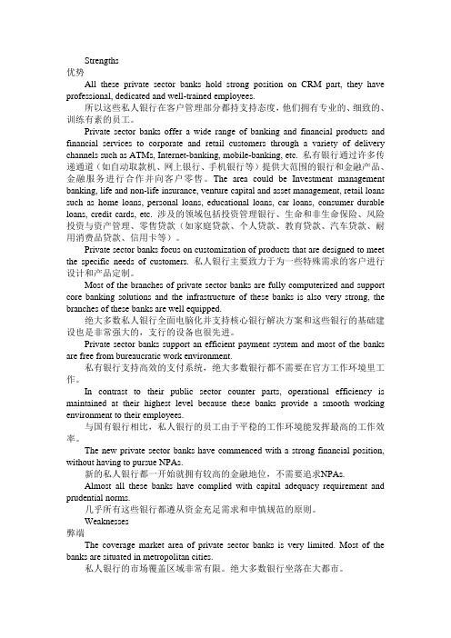
Strengths优势All these private sector banks hold strong position on CRM part, they have professional, dedicated and well-trained employees.所以这些私人银行在客户管理部分都持支持态度,他们拥有专业的、细致的、训练有素的员工。
Private sector banks offer a wide range of banking and financial products and financial services to corporate and retail customers through a variety of delivery channels such as ATMs, Internet-banking, mobile-banking, etc. 私有银行通过许多传递通道(如自动取款机、网上银行、手机银行等)提供大范围的银行和金融产品、金融服务进行合作并向客户零售。
The area could be Investment management banking, life and non-life insurance, venture capital and asset management, retail loans such as home loans, personal loans, educational loans, car loans, consumer durable loans, credit cards, etc. 涉及的领域包括投资管理银行、生命和非生命保险、风险投资与资产管理、零售贷款(如家庭贷款、个人贷款、教育贷款、汽车贷款、耐用消费品贷款、信用卡等)。
Private sector banks focus on customization of products that are designed to meet the specific needs of customers. 私人银行主要致力于为一些特殊需求的客户进行设计和产品定制。
毕业论文外文翻译格式【范本模板】
因为学校对毕业论文中的外文翻译并无规定,为统一起见,特做以下要求:1、每篇字数为1500字左右,共两篇;2、每篇由两部分组成:译文+原文.3 附件中是一篇范本,具体字号、字体已标注。
外文翻译(包含原文)(宋体四号加粗)外文翻译一(宋体四号加粗)作者:(宋体小四号加粗)Kim Mee Hyun Director, Policy Research & Development Team,Korean Film Council(小四号)出处:(宋体小四号加粗)Korean Cinema from Origins to Renaissance(P358~P340) 韩国电影的发展及前景(标题:宋体四号加粗)1996~现在数量上的增长(正文:宋体小四)在过去的十年间,韩国电影经历了难以置信的增长。
上个世纪60年代,韩国电影迅速崛起,然而很快便陷入停滞状态,直到90年代以后,韩国电影又重新进入繁盛时期。
在这个时期,韩国电影在数量上并没有大幅的增长,但多部电影的观影人数达到了上千万人次。
1996年,韩国本土电影的市场占有量只有23.1%。
但是到了1998年,市场占有量增长到35。
8%,到2001年更是达到了50%。
虽然从1996年开始,韩国电影一直处在不断上升的过程中,但是直到1999年姜帝圭导演的《生死谍变》的成功才诞生了韩国电影的又一个高峰。
虽然《生死谍变》创造了韩国电影史上的最高电影票房纪录,但是1999年以后最高票房纪录几乎每年都会被刷新。
当人们都在津津乐道所谓的“韩国大片”时,2000年朴赞郁导演的《共同警备区JSA》和2001年郭暻泽导演的《朋友》均成功刷新了韩国电影最高票房纪录.2003年康佑硕导演的《实尾岛》和2004年姜帝圭导演的又一部力作《太极旗飘扬》开创了观影人数上千万人次的时代。
姜帝圭和康佑硕导演在韩国电影票房史上扮演了十分重要的角色。
从1993年的《特警冤家》到2003年的《实尾岛》,康佑硕导演了多部成功的电影。
外文翻译译文
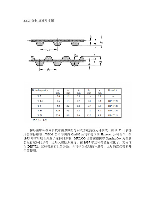
2.3.2 公制,标准尺寸图梯形齿廓标准同步皮带由聚氨酯与钢或芳纶抗拉元件制成。
符号T代表梯形齿廓标准带。
WHM公司与国内GmbH公司和德国的Hanover公司合作,在1995年前后联合开发了这种同步带。
MULCO团体在德国以Synchroflex为品牌名发行这种同步带,之后又在欧洲发行。
在1997年这种带被标准化了,其标准为DIN772。
这些带遍布世界各地,并可作为成型的环形带,无尽的连接带和开口带使用。
具有梯形齿廓和公制标准尺寸,AT同步带是T型同步带的一个发展。
它们由由聚氨酯与钢或芳纶抗拉元件制成。
与T型同步带先比,AT型同步带有更宽的齿形截面和更强的抗拉构件。
AT型同步带一个特殊的特点是带齿齿隙紧靠带轮槽底座。
德国的MULCO和Hanover公司开发了这种类型的同步带,并在1980年左右以Synchroflex为品牌发行了这种带。
这些带遍布世界各地,并可作为成型的环形带,无尽的连接带和开口带使用。
这些带ISO 13050 标准用符号H表示,也被称为HTD同步带。
HTD代表大扭矩驱动。
这种同步带是由氯丁橡胶与玻璃纤维抗拉元件和聚酰胺纤维织物制成,并由在1973年引领美国市场的Gates公司开发。
曲齿的几何形状是圆形,较大的齿高显然增加了齿承载能力和抗牙跳能力。
这种带在世界各地都可以看到,许多制造商都参与它的生产。
它们也用聚氨酯,任选与钢丝帘线或芳纶抗拉元件制造。
用户可以从无尽的成型带,开口带和连续挤压环形带中选择使用。
这些带ISO 13050 标准用符号R表示,也被称为RPP同步带。
RPP代表橡胶抛物线。
1985年意大利的公司开发了这种双抛物线齿廓的同步带,他们是由氯丁橡胶与玻璃纤维抗拉元件和聚酰胺纤维织物制成。
这种类型的同步带主要发行在欧洲南部,许多制造商都参与它们的生产。
它们也用聚氨酯,任选钢丝帘线或芳纶抗拉元件制造。
用户可以从无尽的成型带,开口带和连续挤压环形带中选择使用。
这些带ISO 13050 标准用符号S表示,也被称为STD同步带。
(完整版)外文翻译
外文文献原稿和译文原稿logistics distribution center location factors:(1) the goods distribution and quantity. This is the distribution center and distribution of the object, such as goods source and the future of distribution, history and current and future forecast and development, etc. Distribution center should as far as possible and producer form in the area and distribution short optimization. The quantity of goods is along with the growth of the size distribution and constant growth. Goods higher growth rate, the more demand distribution center location is reasonable and reducing conveying process unnecessary waste.(2) transportation conditions. The location of logistics distribution center should be close to the transportation hub, and to form the logistics distribution center in the process of a proper nodes. In the conditional, distribution center should be as close to the railway station, port and highway.(3) land conditions. Logistics distribution center covers an area of land in increasingly expensive problem today is more and more important. Is the use of the existing land or land again? Land price? Whether to conform to the requirements of the plan for the government, and so on, in the construction distribution center have considered.(4) commodities flow. Enterprise production of consumer goods as the population shift and change, should according to enterprise's better distribution system positioning. Meanwhile, industrial products market will transfer change, in order to determine the raw materials and semi-finished products of commodities such as change of flow in the location of logistics distribution center should be considered when the flow of the specific conditions of the relevant goods.(5) other factors. Such as labor, transportation and service convenience degree, investment restrictions, etc.How to reduce logistics cost,enhance the adaptive capacity and strain capacity of distribution center is a key research question of agricultural product logistics distribution center.At present,most of the research on logistics cost concentrates off theoretical analysis of direct factors of logistics cost, and solves the problem of over-high logistics Cost mainly by direct channel solution.This research stresses on the view of how to loeate distribution center, analyzes the influence of locating distribution center on logistics cost.and finds one kind of simple and easy location method by carrying on the location analysis of distribution center through computer modeling and the application of Exeel.So the location of agricultural product logistics distribution center can be achieved scientifically and reasonably, which will attain the goal of reducing logistics cost, and have a decision.making support function to the logisties facilities and planning of agricultural product.The agricultural product logistics distribution center deals with dozens and even hundreds of clients every day, and transactions are made in high-frequency. If the distribution center is far away from other distribution points,the moving and transporting of materials and the collecting of operational data is inconvenient and costly. costly.The modernization of agricultural product logistics s distribution center is a complex engineering system,not only involves logistics technology, information technology, but also logistics management ideas and its methods,in particular the specifying of strategic location and business model is essential for the constructing of distribution center. How to reduce logistics cost,enhance the adaptive capacity and strain capacity of distribution center is a key research question of agricultural product logistics distribution center. The so—called logistics costs refers to the expenditure summation of manpower, material and financial resources in the moving process of the goods.such as loading and unloading,conveying,transport,storage,circulating,processing, information processing and other segments. In a word。
外文翻译及中文译文
车床用于车外圆、端面和镗孔等加工的机床称作车床。
车削很少在其他种类的机床上进行,因为其他机床都不能像车床那样方便地进行车削加工。
由于车床除了用于车外圆还能用于镗孔、车端面、钻孔和铰孔,车床的多功能性可以使工件在一次定位安装中完成多种加工。
这就是在生产中普遍使用各种车床比其他种类的机床都要多的原因。
两千多年前就已经有了车床。
现代车床可以追溯到大约1797年,那时亨利•莫德斯利发明了一种具有把主轴和丝杆的车床。
这种车床可以控制工具的机械进给。
这位聪明的英国人还发明了一种把主轴和丝杆相连接的变速装置,这样就可以切削螺纹。
车床的主要部件:床身、主轴箱组件、尾架组件、拖板组、变速齿轮箱、丝杆和光杆。
床身是车床的基础件。
它通常是由经过充分正火或时效处理的灰铸铁或者球墨铸铁制成,它是一个坚固的刚性框架,所有其他主要部件都安装在床身上。
通常在球墨铸铁制成,它是一个坚固的刚性框架,所有其他主要部件都安装在床身上。
通常在床身上面有内外两组平行的导轨。
一些制造厂生产的四个导轨都采用倒“V”,而另一些制造厂则将倒“V”形导轨和平面导轨结合。
由于其他的部件要安装在导轨上并(或)在导轨上移动,导轨要经过精密加工,以保证其装配精度。
同样地,在操作中应该小心,以避免损伤导轨。
导轨上的任何误差,常常会使整个机床的精度遭到破坏。
大多数现代车床的导轨要进行表面淬火处理。
以减少磨损和擦伤,具有更大的耐磨性。
主轴箱安装在床身一端内导轨的固定位置上。
它提供动力。
使工件在各种速度下旋转。
它基本上由一个安装在精密轴承中的空心轴和一系列变速齿轮---类似于卡车变速箱所组成,通过变速齿轮,主轴可以在许多中转速的旋转。
大多数车床有8~18中转速,一般按等比级数排列。
在现代车床上只需扳动2~4个手柄,就能得到全部挡位的转速。
目前发展的趋势是通过电气的或机械的装置进行无级变速。
由于车床的精度在很大程度上取决于主轴,因此主轴的结构尺寸较大,通常安装在紧密配合的重型圆锤滚子轴承或球轴承中。
外文翻译原文
IntroductionLatvian legislation for forest protection belts Latvian legislation demands that forest protection belts are established around all cities and towns. The concept of protection belts originates from the Soviet Era and is maintained in Latvian legislation despite the radical changes to the political system after regaining indepen-dence in 1991. The legal background for the establish-ment of protection belts is as follows:•Law on Protection Belts (1997, 2002)•Forest Law (2000)•Law on Planning of Territorial Development (1998).Designating a greenbelt around the city of Riga, LatviaJanis DonisLatvian State Forestry Research Institute ‘Silava’, Salaspils, LatviaAbstract: Latvian legislation demands that forest protection belts are established around all cities and towns. The main goal of a protection belt is to provide suitable opportuni-ties for recreation to urban dwellers and to minimise any negative impacts caused by urban areas on the surrounding environment. Legislation states the main principles to be adopted, which include the maximum area of protection belts, their integration in terri-torial development plans and restrictions placed on forest management activities. The largest part of the forest area around Riga is owned by the municipality of Riga, which, as a result, has two competing interests: to satisfy the recreational needs of the inhabitants of Riga, and to maximise the income from its property. In order to compile sufficient background information to solve this problem, the Board of Forests of Riga Municipality initiated the preparation of a proposal for the designation of a new protection belt.The proposal was based on the development and application of a theoretical framework developed during the 1980s. The analysis of the recreational value of the forest (5 class-es of attractiveness) was carried out based on categories of forest type, dominant tree species, dominant age, stand density, distance from urban areas and the presence of at-tractive objects. Information was derived from forest inventory databases, digital forest maps and topographic maps. Additional information was digitised and processed using ArcView GIS 3.2. Local foresters were asked about the recreation factors unique to differ-ent locations, such as the number of visitors and the main recreation activities. From a recreational point of view and taking into account legal restrictions and development plans for the Riga region, it was proposed to create three types of zones in the forest: a protection belt, visually sensitive areas and non-restricted areas.Key words:greenbelt forest, recreational value, GIS, zoningThe Law on Protection Belts states that protection belts around cities (with forests as part of a green zone)have to be established (a) to provide suitable conditions for recreation and the improvement of the health of urban dwellers, and (b) to minimise the negative im-pact of urban areas on the surrounding environment.Urban For.Urban Green.2 (2003):031–0391618-8667/03/02/01-031 $ 15.00/0Address for correspondence:Latvian State Forestry Re-search Institute ‘Silava’, Rı¯gas iela 111, Salaspils, LV-2169,Latvia. E-mail: donis@silava.lv© Urban & Fischer Verlaghttp://www.urbanfischer.de/journals/ufugRegulation nr 263 (19.06.2001) on the ‘Methodology for the establishment of forest protection belts around towns’issued by the Cabinet of Ministers (CM) states: (a) The area of a protection belt depends on the numberof inhabitants in the town: towns with up to 10,000 inhabitants should have a maximum of 100 ha of protection belt, those with between 10,000 and 100,000 inhabitants a maximum of 1,500 ha, and towns with more than 100,000 inhabitants a maxi-mum of 15,000 ha;(b) the borders of protection belts have to be able to beidentifiable on the ground, using features such as roads, ditches, power lines, and so forth;(c) protection belts have to be recorded in the territorialplans of regions adjacent to the town or city; and (d) establishment of protection belts has to be agreedupon by local municipalities.According to law, protection belts should be man-aged using adapted silvicultural measures. Clear-cut-ting, for example, is prohibited in a protection belt to mitigate any negative impacts of the city on the sur-rounding environment. The Forest Law of 2000 and subsequent regulations including the Regulation on Cutting of Trees, and the Regulation on Nature Conser-vation in Forestry define clear-cuts as felled areas larg-er than 0.1 ha where the basal area is reduced below a critical level in one year. These regulations also state the permitted intensity and periodicity of selective cut-ting (30–50%, at least 5 years between entries).The third element of the legal framework relevant for protection belts in Latvia is the Law on Planning of Territorial Development (1998). It defines:(a) Principles and responsibilities of the different or-ganisations involved;(b) the contents of territorial plans;(c) the procedures for public hearing; and(d) the procedures for the acceptance of plans.The law also states that protection belts around towns have to be designated in territorial plans. Thus, the legislation gives very detailed descriptions of the restrictions to maximum area, activities and guidelines for delineation and so forth, while there are no ‘rules’for the choice of what areas are to be included in pro-tection belts. It is up to territorial planners to propose what areas to include and for negotiation among mu-nicipalities to approve the selection.Protection belt for the city of RigaRiga and the Riga region are situated in the Coastal Lowland of Latvia within the Gulf of Riga. The main landform types are the Baltic Ice Lake plain, the Litto-rina Sea plain and the Limnoglacial plain and bog plain. The total area of the administrative area of the City of Riga covers 307.2 km2, and that of the Riga re-gion 3,059 km2. In 2000 the city of Riga had 815,000 inhabitants, while an additional 145,000 people resided in the greater Riga region. During the last decade the number of inhabitants in Riga decreased by 10.5%and in Riga region by 5.3%. In the mid-1990s the main types of industry in Riga were food processing, timber and wood processing, metal fabricating and engineer-ing, while in the region agriculture and forestry, wood processing, pharmaceuticals, and the power industry were the main activities. Due to reduced industrial ac-tivities today, the main sources of pollution in Riga re-gion are road transport and households.The greater part of the Riga region is covered by for-est, i.e. 1,642 km2or 53%. About 26% of the land is used for agriculture, 4% is covered by bogs, and 4% by water. The Riga region also has a coastal dune zone of some 30 km along the Gulf of Riga. The main tree species to be found in the Riga region are Scots pine (Pinus sylvestris L.),birch (Betula spp.) and Norway spruce (Picea abies (L.) Karsten) (see Table 1). In the administrative area of the city of Riga, 57 km2 or about 19% of the land area is forest. Scots pine is the domi-nant species, covering approx. 46.9 km2(i.e. 88% of the total forest area).According to the legislation described before, a pro-tection belt around Riga city, with a maximum size of 15,000 ha, could be designated. Moreover, any propos-al has to be agreed upon among 24 local municipalities. The Riga region is divided into 24 administrative units: 7 towns and 17 pagasts or ‘parishes’.Riga municipality currently owns more than 55,600 ha of forests. Most are situated in the vicinity of Riga. Four forest administrative districts lie completely with-in Riga region and close to Riga city (see Fig. 1). The total area of these districts is 44,158 ha out of which forest stands cover 36,064 ha (82%). Thus the Riga municipality forests of those 4 districts cover only 17% of the total forest area of the Region. The dominant tree species in the municipally owned forests are Scots32J.Donis:Designating a greenbelt around the city of Riga,LatviaUrban For.Urban Green.2 (2003)Table 1.Tree species composition in the Riga region Dominant tree Area covered, ha Average age, years species––––––––––––––––––––––––––––––––––––––––––––––––––––––––––––––––––––––––––––––Total Municipa-Total Municipa-lity*lity* Scots pine95,27627,3718581 Norway spruce20,8493,0175139Birch30,5585,1246056 Other10,438552––Total157,12136,0647369*Data only for the 4 forest districts of the Riga city munici-pality that are entirely situated within the Riga region.pine, birch and Norway spruce. These cover 76%, re-spectively 14% and 8% of the forest area. Other species cover less than 2% of the area.Until the re-establishment of Latvian independence almost all forestland was owned by the state but since then many areas have been returned to their former owners and are now privately owned. Current regula-tions state that until the designation of new boundaries for protection belts has been agreed upon, all forests of the previously existing and protected green zone have to remain protected whatever their functional role or ownership status. Consequently almost all forests of the Riga municipality located in the Riga region have management restrictions placed on them, and the same can be said for forests of other owners within the previ-ously existing green zone. Currently, therefore, on the one hand significant recreation opportunities for urban dwellers are provided, while on the other hand forest owners’rights to obtain income from timber harvest in the suburban areas continue to be restricted. Suburban municipalities also lose income because of reduced land taxes from land with management restrictions.The board of Forests of the Municipality of Riga there-fore initiated the preparation of a proposal to designate a new protection belt.Study to support protection belt designation The main objective of the study presented here has been to obtain background information in preparation for further discussions with local municipalities. Stud-ies in Latvia as well as elsewhere have revealed that recreational values of forests depend mainly on forest characteristics, location and level of pollution (Emsis et al. 1979; Emsis 1989; Holgen et al. 2000; Lindhagen & Hörnsten 2000; Rieps ˇas 1994; Su ¯na 1973, 1979). A very important aspect is the distance to the forest from places where people live (e.g. Rieps ˇas 1994). The abil-ity of a forest stand to purify the air by filtering or ab-sorbing dust, micro-organisms, and noxious gases de-pends on tree and shrub species composition, age, tree size and stand density (Emsis 1989). Stands purify the air most effectively at the time of maximum current an-nual volume increment, usually between 30 to 60 years of age in Latvian conditions, depending on species.Recreational value, on the other hand, increases with age (and tree size) and reaches its maximum consider-ably later. Taking into account the peculiarities of the dispersal of pollution as described by Laivin ‚s ˇ et al.(1993) and Za ¯lı¯tis (1993), selective cutting is prefer-able in the vicinity of a pollution source, especially ifJ.Donis:Designating a greenbelt around the city of Riga,Latvia 33Urban For.Urban Green.2 (2003)Fig. 1.Location ofthe Riga municipali-ty forests in the Riga region.the forest consists of a narrow strip between the pollu-tion source and housing. If the distance between a pol-lution source and housing exceeds several kilometres, a patch clear-cut system with stands of different ages is sufficient to provide a reduction in the negative impact of urban areas. Taking into account the fact that closer to residential areas it is more important to consider the visual qualities of the forest (e.g. Tyrväinen et al. 2003), this purification ability can generally be ignored when planning protection belts.MethodsThis study to support the designating of the Riga pro-tection belt used the following data sources for analysis (see Fig. 2): forest inventory databases, digital forest maps of the Riga municipal forests which are situated outside the administrative borders of the city (55,600 ha of which 44,158 ha located in the Riga region) (see Fig. 1), and corresponding topographic maps.The study and its developed proposal are based on an application of a theoretical approach developed during the 1980s by the Latvian State Forestry Research Insti-tute ‘Silava’(Emsis 1989) and the Lithuanian Forestry Research Institute (Riepsˇas 1994). According to the methodology developed by Emsis (1989), the first step in the process is to evaluate the recreational potential of the forest stands. This is carried out by analysing the following factors:• The tolerance of the forest ecosystem to different lev-els of anthropogenic (recreation) loading;• the status of forest ecosystems in terms of the damage or degradation as a result of recreational use;•the suitability of the landscape for non-utilitarian recreation (recreational value); and• the existing and potential levels of recreational loads.The second step involves evaluating the existing andexpected functional roles of the forest.The tolerance of the forest ecosystem to different levels of anthropogenic impact or loading is evaluated using a framework based on a combination of forest type, dominant tree species, dominant age group, soil type and relief, according to the stability of ecosystem. All stands are classified into one of five tolerance classes. The highest score is given to mature deciduous forests on mesotrophic and mesic soils on flat topogra-phy, while the lowest score is given to young pine stands on oligotrophic soils on steep slopes (forests on dunes).In this study ecosystem tolerance could not be evalu-ated, as it was primarily a desk using existing databas-es, and topographic relief maps were not available in digital form. The status of the forest ecosystem in rela-tion to damage or degradation was evaluated in terms of the degree of change in vegetation cover, under-growth, tree root exposure of the and level of littering, classified into three classes.Assessment of the recreational value of the forest stands was calculated using a formula developed by Riepsˇas (1994):Recreational value VR= (VS*kW*kS+VA)*kPWhere VSis stand suitability based on key internal at-tributes of the stand, such as species, age, stand densityand forest type. VSvalues range from 0 for young, high-density grey alder (Alnus incana L.) on wet peat soils, to 100 for average density mature pine stands ondry mineral soils. kwis a coefficient depending on the distance of the stand from watercourses, ranging from0.1 for stands further than 2 km from watercourses to1.0 for stands up to 500 m from watercourses. kSis a coefficient depending on the distance of the stand from urban areas, ranging from 0.1 for stands further than34J.Donis:Designating a greenbelt around the city of Riga,LatviaUrban For.Urban Green.2 (2003)Fig. 2.Structure of data sources used in data ana-lysis.80 km from Riga to 1.0 for stands within 30 km ofRiga. VA is an additional value depending on the pres-ence of attractive features, for example, 25 for forest stands up to 500 m from settlements, including summer cottages, or for areas intensively used for recreation ac-cording to information of local foresters. kP is a coeffi-cient depending on the level of environmental pollu-tion. Its value is 0 if the actual pollution level exceeds limit values, 0.5 if the level of environment pollution is between 50% and 100% of limit values, and 1 if the level of actual pollution is less than 50% of the limit values. In this study a coefficient of 1.0 was used, be-cause SO2and O3concentrations measured by Rigabackground measuring stations did not exceed 50% of the limit values (Fammler et al. 2000).The division of stands into classes of stand suitabili-ty is based on studies of visitors’preferences. Coeffi-cients kw, ksand VAare based on visitors’spatial distri-bution and show the ratio of the number of visitors in different zones. The evaluation of existing and expect-ed recreational loads was carried out by local foresters. They marked existing and potential recreation places on forest maps, including:•Small areas or sites for activities such as swimming, barbecuing, and so forth.•Recreation territories, defined as areas of 20 ha or more where people stay longer periods for walking, jogging, skiing or other forms of both active and pas-sive recreation.•Traditionally popular places for the collection of berries and mushrooms.•Recreational routes, including routes from public transport stops to recreation sites or recreation terri-tories, and between recreation sites and territories. For each recreation site and recreation territory data on the main seasons of use, the periods of use (week-days, weekends), and the average number of people in ‘rush-hours’during good weather conditions was col-lected or estimated.Data processing was carried out using ArcView GIS3.2a, Visual Fox pro and Microsoft Excel. VS values foreach stand were calculated from information in the for-est database using Visual Fox pro. Information collect-ed at a later stage from local foresters was digitised using separate themes (layers) in ArcView GIS 3.2a. Buffer zones along watercourses and water bodies, as well as residential areas, recreation sites and territoriesand recreation routes were created to get kW ,kSand VAvalues for each stand. Then VR values were calculatedfor each stand.A selection of recreation sites and territories was vis-ited by members of the project team in order to evalu-ate the state of the ecosystem with respect to wear and tear arising from different levels of recreational use. An evaluation of the existing functional role of each forest stand was carried out using the existing categories offorest protection. The anticipated future functional role was evaluated by annalysing the recreational value of stands, known expectations in terms of territorial de-velopment, and existing legal restrictions in order to find a compromise between recreation possibilities and other services of the forest. Next, a first draft of the protection belt was drawn according to experts’judge-ment. This draft included forests with high recreational value adjacent to residential areas and summer cot-tages, and larger tracts intensively used for recreation with medium to high recreational value.ResultsAccording to the original forest classification 65% of the total forest land area was designated as a commer-cial greenbelt forest, for which the main management goals are timber production and environmental consid-erations. The remaining 35% were designated as pro-tected (see Table 2). With regards to protected areas in Latvia: the main management goals of nature parks are nature conservation and recreation, including some ed-ucation. The goal for nature reserves is nature conser-vation, while that of the protected greenbelt forests is recreation.While interviewing local foresters it was revealed that they find it difficult to evaluate dispersed recreation loads (for example collection of berries, mushrooms). The assessments of foresters varied greatly and were considered to be unreliable. It was therefore decided to map only the places important for recreation, but not to use the inaccurate estimates of visitor numbers.In Latvia, special investigations have to be carried out in order to develop management objectives and principles for protected forests as part of the preparation of management plans. Pilot studies and visits to some of the recreation areas have revealed that the evaluation of the state of the forest ecosystem is useful only when de-veloping the detailed management plan. Even then, this is only the case for places identified by local foresters as recreation sites or territories, because otherwise it is too time consuming to carry out fieldwork which provides little useful additional information.Calculated VSvalues show that on average the forests studied have a medium suitability value for recreation (average score 47) (see Table 2). There are considerable differences between districts, with aver-age value ranging from 32 points in Olaine to 66 points in the Garkalne district. This indicates that the average stands in the Garkalne district are more suitable for recreation than those in other districts. If other aspects are taken into account, such as distance from wherepeople live, and VRvalues are calculated it can be seenJ.Donis:Designating a greenbelt around the city of Riga,Latvia35Urban For.Urban Green.2 (2003)that the districts are still ranked as follows: Garkalne,Jugla, Tireli and Olaine.Only 10% of the forest owned by Riga municipality within the Riga region were evaluated as having a high or very high recreational value. 12% had medium recreational value, while large areas used for the col-lection of berries and mushrooms were evaluated as having low or very low recreational value (60% of the total forest area) (see Table 3).More than 16% of the area is covered by bogs, for which according to the used methodology, recreational value was not evaluated at all. Some areas were recorded by the local foresters as important places for the collec-tion of berries. However, more valuable from a recre-ational point of view were those forests situated east and north-east of the city (Garkalne and Jugla districts),while the forests to the south (Olaine and Tireli districts)were found to have a lower recreational value (V R ).36J.Donis:Designating a greenbelt around the city of Riga,LatviaUrban For.Urban Green.2 (2003)Table 2.Distribution of forest by forest categories according to the original functional role Forest districtDataFormer forest category Total–––––––––––––––––––––––––––––––––––––––––––––––––––––––––––––––––––––––––––––––––––––––––––––––––––––––––––––––––––––––––––––––––––––––––––––––Commercial Nature Nature Protected greenbelt forests parks reserves greenbelt forestsGarkalneArea, ha521.27,698.78,219.9Average of V S *61.966.566.2Average of V R **59.350.751.4JuglaArea, ha 8,376.74,098.812,475.4Average of V S 45.656.949.1Average of V R 22.034.025.7OlaineArea, ha 11,765.4707.512,473.0Average of V S 31.941.032.6Average of V R 8.527.410.0TireliArea, ha 8,689.5257.91,025.01,016.910,989.3Average of V S 40.666.710.059.342.3Average of V R 17.055.3 1.044.920.6TotalArea, ha 28,831.6779.11,025.013,522.044,157.6Average of V S 39.863.510.061.647.1Average of V R16.357.91.043.725.9* V S Suitability value – based on stand parameters (0–100 points).** V R Recreation value (0–125 points) based on stand parameters, distance to the residential areas, water and other attractive objects.Table 3.Distribution of forest areas by classes of attractiveness and by designated functional role Designated zoneDataClass of attractiveness Total –––––––––––––––––––––––––––––––––––––––––––––––––––––––––––––––––––––––––––––––––––––––––––––––––––––––––––––––––––––––––––––––––––––––––––––––––––––––n.a.Very low Low Medium High Very high 0<2525,1–5051–7575–100100<Protection belt Area, ha76.7560.12,266.42,222.7850.5743.66719.9Average of V R *0.012.036.063.390.0125.053.4Visually sensitive Area, ha 447.64,150.54,157.7853.4847.1179.810636.1Average of V R 0.07.837.460.996.7125.028.5Non-restricted Area, ha 6,664.715,389.12,548.61,090.5874.8234.026801.7Average of V R 0.0 5.234.761.197.2125.015.8TotalArea, ha 7,189.020,099.88,972.74,166.52,572.31,157.344157.6Average of V R0.06.236.362.294.6125.025.9*V R Recreation value (0–125 points) based on stand parameters, distance to the residential areas, water and other attractive objects.Areas along main roads and railways are known to be visually sensitive, because of the large number of peo-ple who can see them during travel. The same is true for forest in the vicinity of small villages. Taking into ac-count the fact that legislation prohibits clear-cuts in pro-tection belts – which is not always necessary in order to maintain the visual quality of the landscape – it was proposed, as part of the zoning strategy, to create so called visually sensitive areas. In these areas the forest owner (Riga municipality) is recommended to use more detailed landscape-planning techniques and to pay more attention to visual aspects during management.As a result of the study, seen from a recreational point of view and taking into account legal restrictions and so forth, it has been proposed to create three zoning categories: (1) protection belts, (2) visually-sensitive areas, and (3) non-restricted areas (see Fig. 3). The protection belt should include:• Forest with high recreational value adjacent to residen-tial areas and summer cottages, to form a 200–500 m wide belt.• Larger tracts of forestland intensively used for recre-ation.The zone of visually-sensitive areas should include:• Forests within the administrative borders of Riga mu-nicipality and in the vicinity of villages (up to 200–500 m distance).• Forests along roads of national and regional impor-tance, railways, watercourses and streams as a protec-tion belt of 100–300 m wide.• Places used for mushroom and berry collection in the original restricted protection belt.• Places that could become important for recreation in the near future.J.Donis:Designating a greenbelt around the city of Riga,Latvia 37Urban For.Urban Green.2 (2003)Table 4.Proposed distribution of forest categories in designated zones (in hectares)Designated zoneFormer forest category Grand Total––––––––––––––––––––––––––––––––––––––––––––––––––––––––––––––––––––––––––––––––––––––––––––––––––––––––––––––––––––––––––––––––––––––––––––––––––––––––––––––––––Commercial Nature Nature Protected greenbelt forests parks reserves greenbelt forests Protection belt355.2779.15,585.76,719.9Visually sensitive areas 3,503.97,132.110,636.1Non-restricted areas 24,972.51,025.0*804.226,801.7Total 28,831.6779.11,025.013,522.044,157.6*Forests within nature reserves are not intended for recreation; their primary management goal is nature conservation.Fig. 3.Proposal for zon-ing of the Riga municipalforests in Riga region.The remaining areas should consequently be classi-fied as non-restricted areas.A revision of the first draft plan was made taking into account the known prospective development plans of Riga and Riga region. As a result, for forests owned by Riga municipality and located in Riga region the pro-posal is to include 6,720 ha in the protection belt (see Table 3). Moreover, it has been suggested to designate 10,636 ha as visually-sensitive areas, but to omit the re-maining 26,802 ha from zoning, as these do not need special management from a recreation point of view. Average recreational values of stands in this area range from 53 (medium), through 28 (low) to 15 points (very low) respectively.As a result, the major part of the forest remains in the same functional category as in the original allocation (see Table 4). As was mentioned above, the classifica-tion described here is only based on recreational as-pects, thus forests in nature reserves are misleadingly shown as non-restricted forests. Only 5,586 ha out of the 13,500 thousand ha of the originally protected greenbelt forests are proposed to be included in the protection belt, while 355 ha of the previous commer-cial greenbelt forests are proposed to be placed under stronger protection.DiscussionForests owned by Riga municipality within the Riga re-gion are divided over 13 rural municipalities. Accord-ing to legislation, revised draft proposals for zoning Riga city forests have to be accepted by Riga munici-pality, while the final decision is up to Riga and the sur-rounding municipalities. The study presented here has provided a tentative estimate of the recreational value and suitability of the forests for recreation and can be used as a starting point for political discussions. At the very beginning the intention was to divide the forests in two categories: the protection belt and the remainder of the forest. During the study it was concluded, however, that a third category would be needed, that of visually sensitive areas. Within this category more attention would have to be paid to the amenity of the landscape, but there would be no need to drastically restrict com-mercial forest management. As nature parks are also designated for recreation, it has been proposed to in-clude all forests of nature parks in the protection belt. It has to be noted that all the forests within the adminis-trative borders of cities, and as such not included in this study, are designated as protected. As a consequence, the forest area available for recreation to the inhabi-tants of Riga would increase to 12,500 ha.Unlike many other European cities, where timber ex-traction is of small importance (Konijnendijk 1999),Riga municipal forests have a considerable economic role. It is estimated that the allowable annual cut in suburban forests amounts to 169,800 m3or 81% of the annual increment (Dubrovskis et al. 2002). It should be kept in mind that income from logging is used for for-est regeneration and tending, forest fire protection and maintenance of recreation facilities.The objective of this study was not to evaluate the precision of the method nor possible errors occurring when applying it. This study revealed, however, the in-completeness of the methodology used. Bogs, which are very sensitive to recreation loads, are ascribed quite a high level of attractiveness from a recreation point of view (for the collection of wild berries), but according to the methodology they are not evaluated at all. All watercourses were assumed to be attractive sites, while the preliminary evaluation of recreation loads showed this not to be true. The use of watercourses is very vari-able and obviously depends on water quality and vege-tation structure of the edges or banks. Another aspect which was not taken into account was that amenity of a forest is not simply the sum of the amenity values of forest stands (Pukkala et al. 1995).It seems that the evaluation based on dominant species is appropriate for screening areas, but for more detailed management plans, species mixture, the number of forest layers, and principles of landscape architecture also have to be taken into account (Bell 1999; Bell & Nikodemus 2000). Various studies have shown that people prefer uneven-aged forests (e.g. Melluma et al. 1982) and uneven-aged stands (e.g. Riepsˇas 1994). The impacts of the screening effect show that there are, even in the visually-sensitive and commercial zones, considerable areas with high and very high recreational value. This is mainly because delineation of zonal boundaries is carried out using easily distinguishable natural lines, and often it is not worth including single stands of high recreational value in the protection belt if, as a consequence, re-strictions on management would be placed over whole compartments of 50 ha.For the preparation of specific management guide-lines detailed field inventories have to be carried out. This has not been done in this study, where more re-liance was placed on the experience of local foresters and existing databases. Detailed economical calcula-tions have yet to be carried out in order to evaluate the direct and indirect value of the forest. These will also assist in obtaining more background information to be used as part of a holistic approach and for development of a decision support system to resolve contradictions between different interest groups.After acceptance of the draft plan by the municipali-ty of Riga, the process of negotiation between Riga and its surrounding municipalities is currently ongoing.38J.Donis:Designating a greenbelt around the city of Riga,Latvia Urban For.Urban Green.2 (2003)。
计算机外文翻译(完整)
计算机外⽂翻译(完整)毕业设计(论⽂)外⽂资料翻译专业:计算机科学与技术姓名:王成明学号:06120186外⽂出处:The History of the Internet附件: 1.外⽂原⽂ 2.外⽂资料翻译译⽂;附件1:外⽂原⽂The History of the InternetThe Beginning - ARPAnetThe Internet started as a project by the US government. The object of the project was to create a means of communications between long distance points, in the event of a nation wide emergency or, more specifically, nuclear war. The project was called ARPAnet, and it is what the Internet started as. Funded specifically for military communication, the engineers responsible for ARPANet had no idea of the possibilities of an "Internet."By definition, an 'Internet' is four or more computers connected by a network.ARPAnet achieved its network by using a protocol called TCP/IP. The basics around this protocol was that if information sent over a network failed to get through on one route, it would find another route to work with, as well as establishing a means for one computer to "talk" to another computer, regardless of whether it was a PC or a Macintosh.By the 80's ARPAnet, just years away from becoming the more well known Internet, had 200 computers. The Defense Department, satisfied with ARPAnets results, decided to fully adopt it into service, and connected many military computers and resources into the network. ARPAnet then had 562 computers on its network. By the year 1984, it had over 1000 computers on its network.In 1986 ARPAnet (supposedly) shut down, but only the organization shut down, and the existing networks still existed between the more than 1000 computers. It shut down due to a failied link up with NSF, who wanted to connect its 5 countywide super computers into ARPAnet.With the funding of NSF, new high speed lines were successfully installed at line speeds of 56k (a normal modem nowadays) through telephone lines in 1988. By that time, there were 28,174 computers on the (by then decided) Internet. In 1989 there were 80,000 computers on it. By 1989, there were290,000.Another network was built to support the incredible number of people joining. It was constructed in 1992.Today - The InternetToday, the Internet has become one of the most important technological advancements in the history of humanity. Everyone wants to get 'on line' to experience the wealth of information of the Internet. Millions of people now use the Internet, and it's predicted that by the year 2003 every single person on the planet will have Internet access. The Internet has truly become a way of life in our time and era, and is evolving so quickly its hard to determine where it will go next, as computer and network technology improve every day.HOW IT WORKS:It's a standard thing. People using the Internet. Shopping, playing games,conversing in virtual Internet environments.The Internet is not a 'thing' itself. The Internet cannot just "crash." It functions the same way as the telephone system, only there is no Internet company that runs the Internet.The Internet is a collection of millioins of computers that are all connected to each other, or have the means to connect to each other. The Internet is just like an office network, only it has millions of computers connected to it.The main thing about how the Internet works is communication. How does a computer in Houston know how to access data on a computer in Tokyo to view a webpage?Internet communication, communication among computers connected to the Internet, is based on a language. This language is called TCP/IP. TCP/IP establishes a language for a computer to access and transmit data over the Internet system.But TCP/IP assumes that there is a physical connecetion between onecomputer and another. This is not usually the case. There would have to be a network wire that went to every computer connected to the Internet, but that would make the Internet impossible to access.The physical connection that is requireed is established by way of modems,phonelines, and other modem cable connections (like cable modems or DSL). Modems on computers read and transmit data over established lines,which could be phonelines or data lines. The actual hard core connections are established among computers called routers.A router is a computer that serves as a traffic controller for information.To explain this better, let's look at how a standard computer might viewa webpage.1. The user's computer dials into an Internet Service Provider (ISP). The ISP might in turn be connected to another ISP, or a straight connection into the Internet backbone.2. The user launches a web browser like Netscape or Internet Explorer and types in an internet location to go to.3. Here's where the tricky part comes in. First, the computer sends data about it's data request to a router. A router is a very high speed powerful computer running special software. The collection of routers in the world make what is called a "backbone," on which all the data on the Internet is transferred. The backbone presently operates at a speed of several gigabytes per-second. Such a speed compared to a normal modem is like comparing the heat of the sun to the heat of an ice-cube.Routers handle data that is going back and forth. A router puts small chunks of data into packages called packets, which function similarly to envelopes. So, when the request for the webpage goes through, it uses TCP/IP protocols to tell the router what to do with the data, where it's going, and overall where the user wants to go.4. The router sends these packets to other routers, eventually leadingto the target computer. It's like whisper down the lane (only the information remains intact).5. When the information reaches the target web server, the webserver then begins to send the web page back. A webserver is the computer where the webpage is stored that is running a program that handles requests for the webpage and sends the webpage to whoever wants to see it.6. The webpage is put in packets, sent through routers, and arrive at the users computer where the user can view the webpage once it is assembled.The packets which contain the data also contain special information that lets routers and other computers know how to reassemble the data in the right order.With millions of web pages, and millions of users, using the Internet is not always easy for a beginning user, especially for someone who is not entirely comfortale with using computers. Below you can find tips tricks and help on how to use main services of the Internet.Before you access webpages, you must have a web browser to actually be able to view the webpages. Most Internet Access Providers provide you with a web browser in the software they usually give to customers; you. The fact that you are viewing this page means that you have a web browser. The top two use browsers are Netscape Communicator and Microsoft Internet Explorer. Netscape can be found at /doc/bedc387343323968011c9268.html and MSIE can be found at /doc/bedc387343323968011c9268.html /ie.The fact that you're reading this right now means that you have a web browser.Next you must be familiar with actually using webpages. A webpage is a collection of hyperlinks, images, text, forms, menus, and multimedia. To "navigate" a webpage, simply click the links it provides or follow it's own instructions (like if it has a form you need to use, it will probably instruct you how to use it). Basically, everything about a webpage is made to be self-explanetory. That is the nature of a webpage, to be easily navigatable."Oh no! a 404 error! 'Cannot find web page?'" is a common remark made by new web-users.Sometimes websites have errors. But an error on a website is not the user's fault, of course.A 404 error means that the page you tried to go to does not exist. This could be because the site is still being constructed and the page hasn't been created yet, or because the site author made a typo in the page. There's nothing much to do about a 404 error except for e-mailing the site administrator (of the page you wanted to go to) an telling him/her about the error.A Javascript error is the result of a programming error in the Javascript code of a website. Not all websites utilize Javascript, but many do. Javascript is different from Java, and most browsers now support Javascript. If you are using an old version of a web browser (Netscape 3.0 for example), you might get Javascript errors because sites utilize Javascript versions that your browser does not support. So, you can try getting a newer version of your web browser.E-mail stands for Electronic Mail, and that's what it is. E-mail enables people to send letters, and even files and pictures to each other.To use e-mail, you must have an e-mail client, which is just like a personal post office, since it retrieves and stores e-mail. Secondly, you must have an e-mail account. Most Internet Service Providers provide free e-mail account(s) for free. Some services offer free e-mail, like Hotmail, and Geocities.After configuring your e-mail client with your POP3 and SMTP server address (your e-mail provider will give you that information), you are ready to receive mail.An attachment is a file sent in a letter. If someone sends you an attachment and you don't know who it is, don't run the file, ever. It could be a virus or some other kind of nasty programs. You can't get a virus justby reading e-mail, you'll have to physically execute some form of program for a virus to strike.A signature is a feature of many e-mail programs. A signature is added to the end of every e-mail you send out. You can put a text graphic, your business information, anything you want.Imagine that a computer on the Internet is an island in the sea. The sea is filled with millions of islands. This is the Internet. Imagine an island communicates with other island by sending ships to other islands and receiving ships. The island has ports to accept and send out ships.A computer on the Internet has access nodes called ports. A port is just a symbolic object that allows the computer to operate on a network (or the Internet). This method is similar to the island/ocean symbolism above.Telnet refers to accessing ports on a server directly with a text connection. Almost every kind of Internet function, like accessing web pages,"chatting," and e-mailing is done over a Telnet connection.Telnetting requires a Telnet client. A telnet program comes with the Windows system, so Windows users can access telnet by typing in "telnet" (without the "'s) in the run dialog. Linux has it built into the command line; telnet. A popular telnet program for Macintosh is NCSA telnet.Any server software (web page daemon, chat daemon) can be accessed via telnet, although they are not usually meant to be accessed in such a manner. For instance, it is possible to connect directly to a mail server and check your mail by interfacing with the e-mail server software, but it's easier to use an e-mail client (of course).There are millions of WebPages that come from all over the world, yet how will you know what the address of a page you want is?Search engines save the day. A search engine is a very large website that allows you to search it's own database of websites. For instance, if you wanted to find a website on dogs, you'd search for "dog" or "dogs" or "dog information." Here are a few search-engines.1. Altavista (/doc/bedc387343323968011c9268.html ) - Web spider & Indexed2. Yahoo (/doc/bedc387343323968011c9268.html ) - Web spider & Indexed Collection3. Excite (/doc/bedc387343323968011c9268.html ) - Web spider & Indexed4. Lycos (/doc/bedc387343323968011c9268.html ) - Web spider & Indexed5. Metasearch (/doc/bedc387343323968011c9268.html ) - Multiple searchA web spider is a program used by search engines that goes from page to page, following any link it can possibly find. This means that a search engine can literally map out as much of the Internet as it's own time and speed allows for.An indexed collection uses hand-added links. For instance, on Yahoo's site. You can click on Computers & the Internet. Then you can click on Hardware. Then you can click on Modems, etc., and along the way through sections, there are sites available which relate to what section you're in.Metasearch searches many search engines at the same time, finding the top choices from about 10 search engines, making searching a lot more effective.Once you are able to use search engines, you can effectively find the pages you want.With the arrival of networking and multi user systems, security has always been on the mind of system developers and system operators. Since the dawn of AT&T and its phone network, hackers have been known by many, hackers who find ways all the time of breaking into systems. It used to not be that big of a problem, since networking was limited to big corporate companies or government computers who could afford the necessary computer security.The biggest problem now-a-days is personal information. Why should you be careful while making purchases via a website? Let's look at how the internet works, quickly.The user is transferring credit card information to a webpage. Looks safe, right? Not necessarily. As the user submits the information, it is being streamed through a series of computers that make up the Internet backbone.The information is in little chunks, in packages called packets. Here's the problem: While the information is being transferred through this big backbone, what is preventing a "hacker" from intercepting this data stream at one of the backbone points?Big-brother is not watching you if you access a web site, but users should be aware of potential threats while transmitting private information. There are methods of enforcing security, like password protection, an most importantly, encryption.Encryption means scrambling data into a code that can only be unscrambled on the "other end." Browser's like Netscape Communicator and Internet Explorer feature encryption support for making on-line transfers. Some encryptions work better than others. The most advanced encryption system is called DES (Data Encryption Standard), and it was adopted by the US Defense Department because it was deemed so difficult to 'crack' that they considered it a security risk if it would fall into another countries hands.A DES uses a single key of information to unlock an entire document. The problem is, there are 75 trillion possible keys to use, so it is a highly difficult system to break. One document was cracked and decoded, but it was a combined effort of14,000 computers networked over the Internet that took a while to do it, so most hackers don't have that many resources available.附件2:外⽂资料翻译译⽂Internet的历史起源——ARPAnetInternet是被美国政府作为⼀项⼯程进⾏开发的。
- 1、下载文档前请自行甄别文档内容的完整性,平台不提供额外的编辑、内容补充、找答案等附加服务。
- 2、"仅部分预览"的文档,不可在线预览部分如存在完整性等问题,可反馈申请退款(可完整预览的文档不适用该条件!)。
- 3、如文档侵犯您的权益,请联系客服反馈,我们会尽快为您处理(人工客服工作时间:9:00-18:30)。
附件3:论文题目外文翻译外文翻译1译文:************的影响(中文宋体四号)原文:Impact on textile ( Times New Roman NO.4)作者:C.W.Kan出处:按照参考文献格式如下外文翻译2译文:整体穿着舒适度指数作为棉织物的整体服用性能客观参数特性原文:Total Wear Comfort Index as an Objective Parameter for Characterization of Overall Wear ability of Cotton Fabrics作者:Sheela Raj, S.Sreenivasan出处:Journal of Engineered Fibers and Fabrics, V olume 4, Issue4, 20091外文翻译1:译文:激光对聚酯纤维织物性能的影响(宋体三号)1、介绍正文宋体小四号,1.5倍行距在过去的十年里,运用诸如紫外线照射、等离子体、电子束和离子束进行织物表面处理,用以改变纺织品材料的性能的发展已经取得了相当大的成就,材料表面的激光改性是研究最多的技术之一。
对聚合物材料、木材、金属、半导体、电介质和石英进行激光照射改性,常常在材料的表面会表现出物理和化学变化,这一理论已被证明。
对于聚合物,对一些尺寸在微米范围的凹槽的易确定方位结构或脉动结构在其表面施于高于所谓的消融阙值激光影响的研究已经被开发。
例如波长248纳米、能量约30 mJ /cm2的激光照射后的聚酯纤维。
高吸收激光辐射的聚合物如聚酯纤维在表满形态上可以形成特殊性的改变。
物理和化学性质在激光照射后也受到影响。
因此,我们有理由相信聚合物这样的表面改性对织物性能会有重要的影响。
为了找出聚酯纤维的哪些性能是受激光照射的影响,我们采用不同的实验和测试仪器来表现和处理样品。
原文:Impact on textile properties of polyester with laser( TimeNew Roman No.3 加粗)1. INTRODUCTION正文TIME NEW ROMAN 小四 1.5行距段落两端对齐In the last decade, considerable effort has been made in developing surface treatments such as UV irradiation, plasma, electron beam and ion beam to modify the properties of textile materials. Laser modification on material surface is one of the most studied technologies.It has been shown that materials like polymers, woods, metals, semiconductors, dielectrics and quartz modified by laser irradiation often exhibit physical and chemical changes in the material’s surface. In the case of polymers, some well-oriented structure of grooves or ripple structures with dimensions in the range of micrometre are developed on surface with irradiation fluence above the so-called ablation threshold, e.g. a polyester irradiated by a laser of wavelength 248 nm with energy of about 30 mJ/cm2. The laser irradiation of highly absorbing polymers such as polyester can generate characteristic modifications of the surface morphology. The physical and chemical properties are also affected after laser irradiation. Hence, it is reasonable to believe that such surface modification of a polymer may have an important impact on its textile properties In order to find out which property of polyester is affected by laser irradiation.......外文翻译2:译文:整体穿着舒适度指数作为棉织物的整体服用性能客观参数特性摘要穿着者在一个给定的环境条件下所经历的身体的舒适状态,面料的触觉,温度和湿度的输运特性的变化对此有很大的影响。
为了深入研究了解织物的手感和穿着舒适性,本文提出了需要了解相关的纤维,纱线和织物结构参数。
从本研究获得的结果提供了宝贵深入的棉织物工程要求的质量特性,以便提供最佳的穿着舒适性。
面料运输特性(透气性和透湿性)的一个全面的分级指标集成已经能导出分级的端将织物的利用率与织物的手感并列,这最终决定了服装面料的整体质量。
1.引言服装的舒适性,作为一个基本而普遍的消费者需要,被定义为在一个愉快的状态下而产生的心理和生理上一个人与环境的和谐相处。
文献中一般将服装的舒适性分为三大类(a)美观舒适性(b)生理的热舒适性(c)触觉的舒适性。
影响顾客的喜好的审美情趣或心理慰藉主要是基于主观感受和时尚潮流。
另一方面,织物的生理热舒适性能维持人体和环境之间的热平衡。
服装材料的导热,透水性和透气抵抗性能的共同对穿着者的生理热舒适性状态做出了贡献。
触觉舒适性与服装材料与人体之间的机械相互作用和服装的特性及基本性能要求有关。
虽然织物触觉性能长期以来都用主观的方法对织物的手感进行评估,但在最近几年它已被证明这些可以用可计量物理方法来计量。
最近,对面料研究的主要热潮是对织物摩擦性能的研究,由于织物的摩擦性能对织物的手感起着重要的作用。
因此,手感与实际测量的传输性质将决定服装面料的真正品质。
原文:ABSTRACTThe state of physical comfort experienced by a wearer under a given environmental condition is greatly influenced by the tactile, thermal and moisture transport properties of the fabric. An in depth study carried out to understand fabric handle and wear comfort in relation to fiber, yarn and fabric structural parameter is presented in this paper. The results obtained from this study provide an invaluable insight into engineering of required quality features into the cotton fabrics so as to provide optimum wear comfort. A comprehensive grading index incorporating the transport attributes (air permeability and moisture and thermal transport) of the fabric has been derived to grade end use efficiency of the fabric juxtaposing with fabric hand, which would finally decide the overall quality of the apparel fabric.1. INTRODUCTIONClothing comfort, being a fundamental and universal need for consumers, is defined as a pleasant state arising out of physiological, psychological and physical harmony between a human being and the environment1. The literature2 generally classifies clothing comfort into three broad categories (a) aesthetic comfort (b) thermo-physiological comfort and (c) tactile comfort. Aesthetic appeal or psychological comfort is mainly based on subjective feelings and fashion trends that influence customer preferences. On the other hand, Thermophysiological comfort relates to the ability of the fabric to maintain thermal equilibrium between the human body and the environment. Thermal, moisture and air resistance properties of the clothing material collectively contribute to the state of thermophysiological comfort of the wearer. The tactile comfort is related to mechanical interaction between the clothing material and the human body and is an intrinsic and essential performance requirement in clothing. Although the fabric tactile properties have long being evaluated by a subjective method called fabric handle3, it has been demonstrated in recent.。