FME转换器中文说明
FME的配置和使用说明新2
FME使用说明书目录第一章硬件设备和软件系统要求21.操作系统要求22.硬件设备要求23.服务器设备要求24.客户端设备要求2第二章具体使用31.界面的基本构成32.上半部包括视频捕获窗口Input和视频在线播放窗口Output33.下半部Encoding Options和Encoding Log选项卡33.1 Encoding Options选项卡33.1.1 Video(视频) 43.1.2 Crop(屏幕剪切) 43.1.3 Audio(音频) 53.1.4 Stream to Flash Media Server 53.1.5 Save to File 63.1.6视频Bit Rate的统计63.2 Encoding Log选项卡63.2.1 Log To File 73.2.2 日志的输出信息(初始化信息) 73.2.3 日志的输出信息(视频发布开始后的信息) 73.2.4 Statistics中的Encoding 73.2.5 Statistics中的Publishing 8第三章FME具体使用实例81.打开FME软件82.配置FME软件的左侧属性93.配置FME软件的右侧属性94.配置好FME软件后,您可以点击Start使用了10附件客户端在线观看多码流视频实例图解和说明10第一章硬件设备和软件系统要求1.操作系统要求Windows® XP +SP2或SP3补丁,Windows Vista® Business, Windows 7显示设备要求:分辨率1,024*768 (32位或更高)图形和声音驱动:Microsoft DirectX End-User Runtime version 9.0c音频编码格式要求:支持MP3、AAC、H.264(高清)及以上2.硬件设备要求处理器要求:Intel® Pentium® 3 及以上配置内存要求:256MB的RAM及以上配置硬盘要求:40MB及以上可用硬盘空间存储器RAM要求:同时推出2个或3个码流视频时,建议2GB的RAM3.服务器设备要求Flash Media Server 2.0.4及更高版本支持高清H.264建议使用Flash Media Server 3版本及以上支持Flash音频格式设备4.客户端设备要求Adobe Flash Player 8 播放器及以上版本支持高清H.264或ACC视频格式需要Adobe Flash Player 9 Update 3及以上版本推荐摄像头型号:Creative Webcam Vista PlusLogitech QuickCam FusionLogitech QuickCam Pro 5000Logitech QuickCam ExpressLogitech QuickCam EasyMicrosoft LifeCam VX-1000推荐采集卡:FireWire, PCI IEEE 1394Osprey 100Osprey 440Osprey 450eOsprey 230Osprey 240eOsprey 530Osprey 560Osprey 700 HDe*Digital Rapids DRC 500Digital Rapids DRC-1600Pinnacle PCTV Pro PCIEpiphan VGA2USB LREpiphan VGA2USB Pro第二章具体使用1.界面的基本构成界面的基本构成如图1所示:图12.上半部包括视频捕获窗口Input和视频在线播放窗口Output上半部包括视频捕获窗口Input和视频在线播放窗口Output,可以分别调整窗口的大小;还有Preview可选项,分别为Input Video(输入窗口是否显示),Output Video(输出窗口是否显示)和Audio(音频效果是否使用)。
FME中文教程

FME 中文教程(2008 版)FME 教程(2008 版)目录FME 起步 ............................................................................................................................................................................................................................................................. 1安装 FME......................................................................................................................................................................................................................................................... 1 授权 FME......................................................................................................................................................................................................................................................... 1 安装 FME Sample Dataset............................................................................................................................................................................................................................... 1 获取帮助 .......................................................................................................................................................................................................................................................... 1第一章 VIEWING DATA-FME UNIVERSAL VIEWER ........................................................................................................................................................................................... 2本章内容 .......................................................................................................................................................................................................................................................... 2 目的 .................................................................................................................................................................................................................................................................. 2 查看数据 .......................................................................................................................................................................................................................................................... 2浏览图形和属性数据 .............................................................................................................................................................................................................................................................. 3 获取坐标系信息...................................................................................................................................................................................................................................................................... 4 过滤要素 ................................................................................................................................................................................................................................................................................. 4不同格式的数据叠加 ...................................................................................................................................................................................................................................... 5 从 Viewer 中导出数据 ..................................................................................................................................................................................................................................... 6第二章 FME UNIVERSAL TRANSLATOR ............................................................................................................................................................................................................... 9本章内容 .......................................................................................................................................................................................................................................................... 9 目的 .................................................................................................................................................................................................................................................................. 9 自动转换 .......................................................................................................................................................................................................................................................... 9 简单要素处理 ................................................................................................................................................................................................................................................ 11 投影数据 ........................................................................................................................................................................................................................................................ 12第三章 自定义数据转换—FME WORKBENCH ................................................................................................................................................................................................ 15本章内容 ........................................................................................................................................................................................................................................................ 15 目标 ................................................................................................................................................................................................................................................................ 152FME 教程(2008 版)创建工作区 .................................................................................................................................................................................................................................................... 15 转换工具介绍 ................................................................................................................................................................................................................................................ 18 创建自定义格式 ............................................................................................................................................................................................................................................ 29保存一个工作区作为自定义类型 ........................................................................................................................................................................................................................................ 30 将自定义格式和另一个不同扩展名的文件联合起来 ........................................................................................................................................................................................................ 31 浏览自定义格式.................................................................................................................................................................................................................................................................... 35自定义转换工具 ............................................................................................................................................................................................................................................ 36创建自定义转换工具 ............................................................................................................................................................................................................................................................ 36 投递自定义转换工具 ............................................................................................................................................................................................................................................................ 40附件 A—了解 WORKBENCH .............................................................................................................................................................................................................................. 42 Workbench 界面 ............................................................................................................................................................................................................................................. 42菜单条和工具条 ............................................................................................................................................................................................................................................ 42增强工作区工具条................................................................................................................................................................................................................................................................ 42 设计布局工具条.................................................................................................................................................................................................................................................................... 42 状态条 ................................................................................................................................................................................................................................................................................... 43Workbench 组成 ............................................................................................................................................................................................................................................. 43颜色定义 ............................................................................................................................................................................................................................................................................... 43快速更改 ........................................................................................................................................................................................................................................................ 44重命名和创建新属性 ............................................................................................................................................................................................................................................................ 44 删除转换工具的连接 ............................................................................................................................................................................................................................................................ 45 插入转换工具的连接 ............................................................................................................................................................................................................................................................ 45 在连接线上插入结点 ............................................................................................................................................................................................................................................................ 463FME 教程(2008 版)FME 起步安装 FMEFME Suite 安装包只有一个单一的应用程序。
FME2021操作指南

FME2021操作指南地籍数据转换思路大纲? 地籍建库中的数据流转过程 ? 数据转换过程的重要性 ? 数据转换的基本思路 ?常见数据格式介绍 ? FME操作地籍建库中的数据流转过程外业采集数据(全站仪、GPS 接收仪等)权属数据整理矢量化(CAD、南方CASS、广州开思等)数据转换数据库服务器(SQL Server、Oracle、ArcSDE 、等空间数据和属性数据) GIS地籍管理软件维护地籍管理数据库数据转换过程的重要性? 数据是地理信息应用管理系统重要的组成部分,被称为GIS的“血液”。
? 如何实现数据在不同平台、不同格式之间的无损转换,实现数据共享,一直是制约GIS项目进度的瓶颈问题。
? 数据转换是外业数据能够成功应用在GIS管理系统的关键步骤。
? 数据转换过程不是简单的数据格式的转换,大部分的GIS平台软件都提供了一些数据格式的转换工具,但是这些工具基本上都是简单的数据格式的转换。
? 数据转换过程即包含空间数据和属性数据基本数据格式的转换,还包含空间数据符号化、空间数据要素的几何类型匹配、拓扑问题处理、空间数据及属性数据等其他数据的逻辑组织等等处理过程。
? 这里以AutoCAD类型数据转换为例。
数据转换的基本思路多种格式,多种介质数据源可批量的,可扩展的数据统一标准,统一格式目标转换方案数据权属调查数据空间数据源数据转换(转换工具)ShapeFile数据数据录入(属性录入工具)MDB属性数据? 数据转换的目标就是形成统一标准、统一格式的目标数据;转换过程无数据丢失。
? 这里选择SHP格式作为空间数据的成果格式,是应为SHP格式是一种开放的空间数据交换格式,在目前使用的GIS系统基本上都实现无损的导入。
? 权属属性数据采用的是access格式存储,扫描件以JPEG文件方式存储。
? 要使整个转换过程高效率的完成,在这个过程中需要加入两个标准,既源数据的标准和目标格式数据标准。
? 一般的源数据都是基于南方CASS的CAD数据。
FME函数功能简介
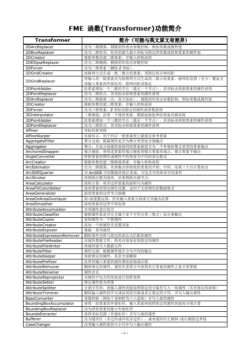
打散列表,使其中每个元素生成单独的要素
ListHistogrammer
对列表中的值进行统计,并生成一个新的列表
ListIndexer
提取列表中指定位置的元素成为要素的属性
ListPopulator
根据一系列输入属性构建列表
ListRangeExtractor
获取列表中的最小、最大值
圆率,计算输入的面状要素的细长程度
Clipper
图形剪切
Cloner
复制所有输入要素
ColorRasterCreator
根据参数创建栅格要素,并输入转换流程
CommonSegmentFinder
公共边检查:候选要素是否具有与基准要素相同的公共边
Concatenator
字符串连接:将任意数量的属性值或常量数次连接起来并输出为新的属性
CaseChanger
改变输入属性值的大小写并写入输出属性
CenterLineReplacer
改为面状要素的中心线。适用于细长型要素
CenterOfGravityReplacer
改为点状要素,坐标为原始要素的“重心”——坐标的平均值
CenterPointReplacer
改为点状要素,坐标为原始要素的最小外接矩形的中心
3DForcer
改为三维要素,Z坐标由指定的属性或常数获得
3DInterpolator
三维插值:沿着一个线状要素、根据起始值和结束值内插高程
3DPointAdder
给要素增加一个三维的节点(最后一个节点),其坐标由原始要素的属性获得
3DPointReplacer
改为三维的点,其坐标由原始要素的属性获得
ListRemover
FME2014转换器参考手册_电子档

3D (1)这些转换器创建并修改三维表面和实体几何。
计算 (1)这些转换器计算某个值,并把它提供给要素的一个新属性集合 (3)这些转换器一次处理一组要素。
坐标系统 (5)这些转换器与坐标系和重投影有关。
数据库 (6)这些转换器允许和外部数据库进行交互。
数据可从数据库中提取,然后合并到要素流中,或合并到要素上。
过滤 (8)这些转换器对要素的图形或/和属性进行测试,并根据测试结果把要素分发到不同的目标中。
几何对象操作 (9)这类转换器是对个别或者成组的要素进行操作。
基本结构 ...............................13 这些转换器提供与底层FME转换引擎设备交互的功能。
JSoN . (15)查询、更新、创建JSoN (JavaScript object Notation) 数据。
KML ...................................15 这些转换器对要素的几何图形或属性进行处理,使其可用OGCKML写模块输出。
线性参考 (16)这些转换器处理FME要素的线性参考数据结构。
列表 ....................................16 这些转换器是对FME属性列表进行操作。
操作....................................17 这些转换器修改(处理)独立于其它要素的图 形或属性。
地图文本 (24)FME ® 转换器参考手册本手册是对每个转换器功能的概要说明。
要获得详细信息,可在Workbench帮助菜单下选择FME转换器,或者访问/KnowledgeDocumentation 下载文档。
这些转换器为要素创建文本标注。
MRF (24)这些转换器用于修复几何图形,尤其是在数据从CAD转换到GIS的过程中。
网络 (25)这些转换器对连接在一个网络中的线状要素进行处理,执行诸如优先级计算和方向纠正之类的操作。
5、FME自定义转换器

FME Desktop ®教程FME 2014版本世纪安图目录转换器 (3)使用转换器 (3)属性按钮的颜色 (3)转换器的参数设置 (4)转换器分类 (4)练习一使用转换器 (7)自定义转换器 (9)创建自定义转换器 (10)使用自定义转换器 (11)练习二创建一个自定义转换器 (12)转换器转换器是FME实现数据转换的重要工具之一,FME的转换器库中包含了400多个功能强大的转换器,能满足不同的转换需求。
我们在上一章节学会了如何添加和简单使用转换器。
本章节进一步介绍转换器的使用方法。
使用转换器属性按钮的颜色当转换器被添加到工作空间中以后,不一定就能成功运行。
你或许发现在转换器右上角属性按钮颜色不一样。
它们分别代表什么含义呢?转换器的属性按钮被标记为不同的颜色,表示当前的设置状态:大多情况下,可以直接使用转换器的默认值,但必要的时候也要重新设置来适应不同的转换情况;如果参数设置框为高亮的红色显示,则表示该参数值为必填值,如下图的Buffer转换器:蓝色:表示已经检查和更改了默认函数设置,并且即将使用这个函数黄色:表示还没有检查默认设置,可以使用这个函数,但是结果可能是不正确的。
红色:表示至少有一个默认值FME 无法提供,在使用函数之前,一定要由用户提供一个设置值。
转换器的参数设置不同转换器的参数设置对话框也不同,关于每个转换器的具体使用方法,可通过点击参数框左下角的帮助按钮来获取帮助文档。
另外,添加到工作空间的转换器,在导航窗口也同样也看到,如下图,Transformers下显示了所有正在使用的转换器,打开前面的加号,就能够看见该转换器的所有参数设置转换器分类FME根据转换器的使用特点和作用对象,将400多个转换器分成二十几种类别,FME2011版还新增了PointCloud(点云类)和Style类转换器。
在转换器库中可找到不同种类下的转换器,如下图。
每种类别的转换器的功能描述和作用对象如下表:练习一使用转换器源数据:某地区行政区图(SHP格式)属性表(Access库)转换任务:为每个行政区附上行政区名称,另外创建行政区边界图层,并重投影到WGS84坐标系下,最后导出TAB格式的政区图。
FME 使用说明书

1FME ® Workbench Transformers Quick-Reference Booklet1 3DThese transformers create and modify three-dimensional surface and solid geometries.1 calculatorsThese transformers calculate a value and supply it to a new attribute on a feature. 3 collEctorsThese transformers operate on collections of features at the same time. The collection of features may be replaced by new features based upon them, have their attributes or geometries merged, or have their orders altered.4 DatabasEThese transformers allow interaction with external databases. Data can be extracted from databases and merged into the feature stream or merged onto features. Arbitrary SQL statements can also be executed.5 filtErsThese transformers perform tests on feature geometry and/or attributes, and allow the feature to be routed to different destinations depending on the outcome of the test.6 gEomEtric opEratorsThese transformers operate on thegeometry of individual features or groups of features.10 infrastructurEThese transformers provide interaction with the underlying FME translation engine facilities. These include functionality to log features, set feature colors, createindividual features and grids of features from nothing, and invoke the FME Viewer on features flowing by.12 linEar rEfErEncingThese transformers work with linear referencing data structures on FME features.12 listsThese transformers operate on FME attribute lists.13 manipulatorsThese transformers modify (manipulate) the geometry or attributes of individual features in isolation from other features. 19 rastErsThese transformers create, use, and output rasters. They operate on data consisting of a regularly spaced grid of values. 22 stringsThese transformers operate on character strings held in FME attributes.23 surfacEsThese transformers create, use, and output surfaces. They operate on data thatdefines a surface through the z coordinate, and then either outputs this surface in a variety of ways or applies the surface to other data.24 WEb sErVicEsThese transformers access web services using the HTTP protocol.25 WorKfloWThese transformers run workspaces either locally or on an FME server.25 XmlThese transformers work with XML data by mapping XML elements into FME features, using stylesheets to convert XML documents, and querying collections of XML data.fmE ® Workbench transformers Quick-reference bookletThis booklet contains a high-level summary of each transformer’s functionality. For detailed information, please visit or select FME Transformers from the Workbench Help menu.2Properties buttonWhat is a transformer?A transformer is an FME Workbench object that carries out the restructuring of features. FME contains over 300 different transformers to carry out different types of restructuring. In the Workbench interface, transformers are stored in the Transformer Gallery, and grouped in categories applicable to their associated functionality.common Elements used in transformer parameter DialogsEvery transformer has a Properties button on the right of the transformer.When you click the Properties button, most transformers display an Edit Parameters dialog. The content of this dialog depends on the transformer, and sometimes even on connections to the transformer. Most transformers have some common user interface elements, however, and those are described here.The Properties button at the top-right of the transformer is color-coded to show the status of the settings. If the Properties button is the same color as the transformer, you can use the transformer with its existing parameters.A yellow Properties button indicates that the transformer contains default settings, but you have not yet accepted them. You can use the transformer in this state, but the workspace results may be unpredictable.A red Properties button means that there is at least one parameter for which FME cannot supply a default value. You must provide a value in the required field(s) before the transformer can be used.When you click a Properties button, the Edit Parameters dialog that appears will usuallyhave some of the common elements shown in this example.You can edit the default transformer name.Required fields are highlighted. If this field is not filled in, the OK button at the bottom of the dialog is disabled.Click OK to accept changes and close the dialog. Note that this button is disabled if required fields have not been populated.The Defaults menu allows you to replace FME defaults for thistransformer with your own parameter defaults. You can always reset the dialog to FME defaults.Click this Help button to open the FME Workbench Transformer helptopic.Replaces the geometry of a feature that has CSG.Creates long, surface or solidgeometries with a fixed cross-sectional profile taken from theoriginal geometry of the feature.Replaces the geometry of a feature from donut or polygon to face.These transformers calculate a value and supply it to a new attribute on a feature.1 FME® Workbench Transformers Quick-Reference BookletConverts an attribute’s value from one numeric system (base) to another,Extracts the minimum and maximum values of the feature’s coordinatesinto new attributes.2Combines feature attributes.Creates bounding boxes for groups of features. One bounding box feature3 FME® Workbench Transformers Quick-Reference BookletDecomposes an aggregate feature into its components.Stores incoming features until they have all arrived and then releasesthem in their original order.Merges the attributes of one feature onto another feature.Finds the closest two CANDIDATE features within some maximum distanceof each BASE feature and some minimum separation in heading between 4Removes duplicate features based on the value of a key attribute.Separates the features routed to it into their original feature types, ifDiscards input features, preserving only every <sample rate>th feature.5 FME® Workbench Transformers Quick-Reference BookletEvaluates one or more FME-style tests on a feature, and routes the featureaccording to the outcome of the tests.These transformers operate on the geometry of individual features or groups ofPerforms warping operations on the spatial coordinates of features. Itis used to adjust a set of observed features so they more closely matchSnaps endpoints of features entering through the CANDIDATE port toendpoints of features entering through the ANCHOR port. ANCHORPerforms a geometric clipping operation.6Builds connections between donut holes with the outer boundary ofa donut, resulting in a polygon-equivalent representation of the input donut.Cuts holes in polygonal features by making polygons completely enclosedSplits an area feature that has holes into its component rings.Interpolates labels along a linear or polygonal feature.7 FME® Workbench Transformers Quick-Reference BookletPerforms a line-on-area overlay.Performs a line-on-line overlay.Takes features as input and processes them based on the specifiedEach point receives the attributes of the area(s) it is contained in, andeach containing area receives the attributes of each point it contains. 8Performs warping operations on the spatial coordinates of features.Checks each feature and removes self-intersections.Snaps end points of lines together if they are within the <tolerance>distance of each other.Cleans up feature geometries by removing spikes in two dimensions.9 FME® Workbench Transformers Quick-Reference BookletComputes topology on input point, line, and/or area features.Breaks an input geometry into triangular units.1011FME ®Workbench Transformers Quick-Reference Booklet12Replaces the geometry of the feature with a two-dimensional box whoseminimums and maximums are fixed values or are taken from attributes inReplaces the feature geometry with a two-dimensional ellipse whoseRemoves any elevation z coordinates that may or may not have beenAdds a two-dimensional point as the last vertex of the feature. Thecoordinates are taken from attributes in the original feature.Replaces the feature’s geometry with a two-dimensional point whosecoordinates are taken from attributes in the original feature.Performs 3D affine transformation on the coordinates of the feature. Thetransformation results in the x and y coordinates being modified as follows:x’ = Ax + By + Cz + Dy’ = Ex + Fy + Gz + H13 FME® Workbench Transformers Quick-Reference BookletPerforms an affine transformation on the feature’s coordinates.Converts angles of a feature’s geometry and/or attributes from oneSets the given attributes to the properties of an arc geometry.Sets the properties of an arc geometry to those specified.Simulates the ArcSDE conversion on a feature by performing ArcSDEtranslation, scaling, and coordinate snapping.Removes all attributes on incoming features that match a given regularRemoves all attributes from the feature, except those chosen in the list.Adds a prefix or suffix to all attributes coming into the transformer.Removes the attributes chosen from the feature. This is not normallynecessary unless the feature will later be processed by a transformer thatmerges attributes onto it from other features.14Replaces the geometry of an area feature with a line that threads throughthe center of the feature. Works best with long, thin features.Replaces the feature’s geometry with a point that is the feature center ofgravity. The center of gravity is the average x, y, and possibly z coordinateReplaces the feature’s geometry with a point that is in the center of thefeature’s bounding box.Ensures that all features output have less than or equal to <maximumvertices> vertices.15 FME® Workbench Transformers Quick-Reference BookletRemoves one or more coordinates from the geometry of the feature.Rounds off the feature’s coordinates to the specified number of decimalConverts coordinate system strings between representations.Adds vertices to the feature by interpolating new coordinates along itsdefinition at some interval of distance.16Provides two types of algorithms: Smoothing and Generalizing. Thesmoothing algorithms determine a new location for each vertex. ThePerforms the following refinements on the feature’s geometry:- Any homogeneous IFMEAggregate will become a multi(IFMEMultiCurve, IFMEMultiArea, IFMEMultiPoint, or IFMEMultiText).- Any IFMEAggregate or multi with only one member is replaced by itssingle part.- Any IFMEDonut with no holes becomes an IFMEPolygon or IFMEEllipse.- Any IFMEPath with only one segment is replaced by that segment.- Consecutive IFMELine segments within an IFMEPath are combined.17 FME® Workbench Transformers Quick-Reference BookletCalculates a Military Grid Reference System (MGRS) code based on the Calculates a Military Grid Reference System (MGRS) code based on the feature’s geometry.Rotates features in a counterclockwise direction about the specified point by the rotation angle measured in degrees.Calls the specified FME Function, optionally putting the resulting value in the Result Attribute. This is a safe way to run FME functions as they areBuilds and queries surfaces, drapes features or changes the surface representation between DEM, TIN, and CONTOURS.Point features are input with the following data contained in the chosenattributes: site name, sector name, azimuth, and radius. Within pointshaving the same site name, points have their geometry changed topolygons approximating sector shapes.Generates a Voronoi diagram or Thiessen polygon from the input POINTS. These transformers access web services using the HTTP protocol.2D2DArcReplacer (Manipulators category), 132DBoxReplacer (Manipulators category), 132DEllipseReplacer (Manipulators category), 132DForcer (Manipulators category), 132DGridCreator (Infrastructure category), 102DGridReplacer (Collectors category), 32DPointAdder (Manipulators category), 132DPointReplacer (Manipulators category), 133D3DAffiner (Manipulators category), 133DArcReplacer (Manipulators category), 133DForcer (Manipulators category), 133DInterpolator (Manipulators category), 133DPointAdder (Manipulators category), 143DPointReplacer (Manipulators category), 14AAffiner (Manipulators category), 14 AffineWarper (Geometric Operators category), 6 AggregateFilter (Filters category), 5Aggregator (Collectors category), 3 AnchoredSnapper (Geometric Operators category), 6 AngleConverter (Manipulators category), 14 ArcEstimator (Manipulators category), 14 ArcPropertyExtractor (Manipulators category), 14 ArcPropertySetter (Manipulators category), 14 ArcSDEGridSnapper (Manipulators category), 14 ArcSDEQuerier (Database category), 4 ArcStroker (Manipulators category), 14 AreaBuilder (Geometric Operators category), 6 AreaCalculator (Calculators category), 1 AreaFillColorSetter (Infrastructure category), 10 AreaOnAreaOverlayer (Geometric Operators category), 6 AttributeAccumulator (Collectors category), 3 AttributeClassifier (Strings category), 22 AttributeCopier (Infrastructure category), 10 AttributeCreator (Infrastructure category), 10 AttributeDereferencer (Infrastructure category), 10 AttributeExploder (Lists category), 12 AttributeExposer (Infrastructure category), 10AttributeExpressionRemover (Manipulators category), 14 AttributeFileReader (Infrastructure category), 10 AttributeFileWriter (Infrastructure category), 10 AttributeFilter (Filters category), 5 AttributeKeeper (Manipulators category), 14 AttributePrefixer (Manipulators category), 14 AttributeRemover (Manipulators category), 14 AttributeRenamer (Infrastructure category), 10 AttributeReprojector (Manipulators category), 14 AttributeRounder (Calculators category), 2 AttributeSetter (Infrastructure category), 10 AttributeSplitter (Strings category), 22 AttributeTrimmer (Strings category), 22BBaseConverter (Calculators category), 2 BoundingBoxAccumulator (Collectors category), 3 BoundingBoxReplacer (Manipulators category), 14 BoundsExtractor (Calculators category), 2 Bufferer (Manipulators category), 15CCaseChanger (Strings category), 22 CenterLineReplacer (Manipulators category), 15 CenterOfGravityReplacer (Manipulators category), 15 CenterPointReplacer (Manipulators category), 15 ChangeDetector (Filters category), 5 CharacterCodeExtractor (Strings category), 22 CharacterEncoder (Strings category), 22Chopper (Manipulators category), 15 CircularityCalculator (Calculators category), 2 Clipper (Geometric Operators category), 6Cloner (Infrastructure category), 10 CommonSegmentFinder (Collectors category), 4 Concatenator (Strings category), 22 ContourGenerator (Surfaces category), 23 ConvexHullAccumulator (Collectors category), 4 ConvexHullReplacer (Manipulators category), 16 CoordinateConcatenator (Calculators category), 2 CoordinateCounter (Calculators category), 2 CoordinateFetcher (Calculators category), 2 CoordinateRemover (Manipulators category), 16CoordinateRounder (Manipulators category), 16 CoordinateSystemDescriptionConverter(Manipulators category), 16 CoordinateSystemFetcher (Manipulators category), 16 CoordinateSystemRemover (Manipulators category), 16 CoordinateSystemSetter (Manipulators category), 16 Counter (Calculators category), 2 CRCCalculator (Calculators category), 2Creator (Infrastructure category), 10 CSGBuilder (3D category), 1CSGEvaluator (3D category), 1Curvefitter (Manipulators category), 16DDateFormatter (Calculators category), 2 Deaggregator (Collectors category), 4 Decelerator ( Web Services category), 24 DecimalDegreesCalculator (Calculators category), 2 DEMDistanceCalculator (Calculators category), 2 DEMGenerator (Surfaces category), 23Densifier (Manipulators category), 16 DimensionExtractor (Calculators category), 2 Dissolver (Geometric Operators category), 7 DistanceSnipper (Linear Referencing category), 12 DMSCalculator (Calculators category), 2 DonutBridgeBuilder (Geometric Operators category), 7 DonutBuilder (Geometric Operators category), 7 DonutHoleExtractor (Geometric Operators category), 7 DuplicateCoordinateRemover (Manipulators category), 17 DuplicateRemover (Filters category), 5EElevationExtractor (Calculators category), 2 EllipsePropertyExtractor (Manipulators category), 17 EllipsePropertySetter (Manipulators category), 17 EnvironmentVariableRetriever (Calculators category), 2 ESRIReprojector (Manipulators category), 17 ExpressionEvaluator (Calculators category), 2 Extender (Manipulators category), 17Extruder (3D category), 1FFaceReplacer (3D category), 1FeatureHolder (Collectors category), 4 FeatureMerger (Collectors category), 4 FeatureTypeExtractor (Infrastructure category), 11 FeatureTypeFilter (Filters category), 5 FMEFunctionCaller (Strings category), 22GGeneralizer (Manipulators category), 17 GeometryCoercer (Manipulators category), 17 GeometryExtractor (Manipulators category), 17 GeometryFilter (Filters category), 5 GeometryOGCValidator (Filters category), 5 GeometryRefiner (Manipulators category), 17 GeometryRemover (Manipulators category), 17 GeometryReplacer (Manipulators category), 18 GeometryTraitFetcher (Manipulators category), 18 GeometryTraitRemover (Manipulators category), 18 GeometryTraitSetter (Manipulators category), 18 GeoRSSFeatureExtractor ( Web Services category), 24 GeoRSSFeatureReplacer ( Web Services category), 24 GMLFeatureExtractor (Manipulators category), 18 GMLFeatureReplacer (Manipulators category), 18 GOIDGenerator (Strings category), 22 GridInQuestReprojector (Manipulators category), 18 GtransAttributeReprojector (Manipulators category), 18 GtransReprojector (Manipulators category), 18HHexDecoder (Strings category), 22 HexEncoder (Strings category), 22 HoleCounter (Calculators category), 2 HTTPDeleter ( Web Services category), 24 HTTPFetcher ( Web Services category), 24 HTTPFileUploader ( Web Services category), 24 HTTPUploader ( Web Services category), 24IImageFetcher ( Web Services category), 24 ImageRasterizer (Rasters category), 19 InsidePointExtractor (Calculators category), 2 InsidePointReplacer (Manipulators category), 18 Intersector (Geometric Operators category), 7JJoiner (Database category), 4JSONExploder ( Web Services category), 24 JSONExtractor ( Web Services category), 24KKMLStyler ( Web Services category), 25LLabeller (Geometric Operators category), 7 LabelPointReplacer (Manipulators category), 18 LatLongToMGRSConverter (Manipulators category), 18 LengthCalculator (Calculators category), 3 LengthToPointCalculator (Linear Referencing category), 12 LineCloser (Manipulators category), 18 LineJoiner (Geometric Operators category), 8 LineOnAreaOverlayer (Geometric Operators category), 8 LineOnLineOverlayer (Geometric Operators category), 8 ListBuilder (Lists category), 12 ListConcatenator (Lists category), 12ListCopier (Lists category), 12 ListDuplicateRemover (Lists category), 12 ListElementCounter (Lists category), 12 ListExploder (Lists category), 12 ListHistogrammer (Lists category), 12ListIndexer (Lists category), 12ListPopulator (Lists category), 12 ListRangeExtractor (Lists category), 12 ListRemover (Lists category), 12ListRenamer (Lists category), 12ListSearcher (Lists category), 13ListSorter (Lists category), 13ListSummer (Lists category), 13Logger (Infrastructure category), 11MMatcher (Filters category), 5 MeasureExtractor (Linear Referencing category), 12 MeasureGenerator (Linear Referencing category), 12 MeasureSetter (Linear Referencing category), 12 MGRSGeometryExtractor (Manipulators category), 18 MGRSGeometryReplacer (Manipulators category), 18MGRSToLatLongConverter (Manipulators category), 18 MinimumSpanningCircleReplacer(Manipulators category), 18 ModuloCounter (Calculators category), 3 MRFCleaner 2D and 3D(Geometric Operators category), 8NNeighborColorSetter (Geometric Operators category), 8 NeighborFinder (Collectors category), 4 NeighborhoodAggregator (Collectors category), 4 NeighborPairFinder (Collectors category), 4 NullAttributeReplacer (Strings category), 22 NumericRasterizer (Rasters category), 20OOffsetter (Manipulators category), 19 OracleQuerier (Database category), 4 OrientationExtractor (Calculators category), 3 Orientor (Manipulators category), 19PParameterFetcher (Infrastructure category), 11 PartCounter (Manipulators category), 19 PathBuilder (Geometric Operators category), 8 PathSplitter (Manipulators category), 19 PenColorSetter (Infrastructure category), 11Player (Infrastructure category), 11 PointConnector (Geometric Operators category), 8 PointOnAreaOverlayer (Geometric Operators category), 8 PointOnLineOverlayer (Geometric Operators category), 8 PointOnPointOverlayer (Geometric Operators category), 8 PointOnRasterValueExtractor (Rasters category), 20 PolygonBuilder (Geometric Operators category), 9 PythonCaller (Infrastructure category), 11 PythonCreator (Infrastructure category), 11RRandomColorSetter (Infrastructure category), 11 RandomNumberGenerator (Calculators category), 3 RasterBandAdder (Rasters category), 20 RasterBandCombiner (Rasters category), 20 RasterBandInterpretationCoercer (Rasters category), 2028RasterBandKeeper (Rasters category), 20 RasterBandMinMaxExtractor (Rasters category), 20 RasterBandNodataSetter (Rasters category), 20 RasterBandOrderer (Rasters category), 20 RasterBandPropertiesExtractor (Rasters category), 20 RasterBandRemover (Rasters category), 20 RasterBandSeparator (Rasters category), 20 RasterCellCoercer (Rasters category), 20 RasterCellOriginSetter (Rasters category), 20 RasterCellValueReplacer (Rasters category), 20 RasterCheckpointer (Rasters category), 20 RasterConsumer (Rasters category), 20 RasterDEMGenerator (Surfaces category), 23 RasterExpressionEvaluator (Rasters category), 20 RasterExtractor (Rasters category), 20 RasterGCPExtractor (Rasters category), 20 RasterGCPSetter (Rasters category), 20 RasterGeoreferencer (Rasters category), 20 RasterInterpretationCoercer (Rasters category), 21 RasterMosaicker (Rasters category), 21 RasterNodataRemover (Rasters category), 21 RasterNumericCreator (Rasters category), 21 RasterPaletteGenerator (Rasters category), 21 RasterPaletteInterpretationCoercer (Rasters category), 21 RasterPaletteNodataSetter (Rasters category), 21 RasterPaletteRemover (Rasters category), 21 RasterPaletteResolver (Rasters category), 21 RasterPropertiesExtractor (Rasters category), 21 RasterPyramider (Rasters category), 21 RasterReader (Rasters category), 21 RasterReplacer (Rasters category), 21 RasterResampler (Rasters category), 21 RasterRGBCreator (Rasters category), 21 RasterRotationApplier (Rasters category), 21 RasterSelector (Rasters category), 21 RasterSubsetter (Rasters category), 21 RasterTiler (Rasters category), 21Recorder (Infrastructure category), 11 ReprojectAngleCalculator (Calculators category), 3 ReprojectLengthCalculator (Calculators category), 3 Reprojector (Manipulators category), 19Rotator (Manipulators category), 19RubberSheeter (Geometric Operators category), 9SSampler (Filters category), 5Scaler (Manipulators category), 19 SchemaMapper (Database category), 5 SecondOrderConformer (Manipulators category), 19 SectorGenerator (Surfaces category), 23 SelfIntersector (Geometric Operators category), 9 ServerJobSubmitter (Workflow category), 25 Snapper (Geometric Operators category), 9Sorter (Collectors category), 4SpatialFilter (Filters category), 6SpatialRelator (Calculators category), 3 SpikeRemover (Geometric Operators category), 9 SQLExecutor (Database category), 5 StatisticsCalculator (Calculators category), 3 StringFormatter (Strings category), 22 StringLengthCalculator (Strings category), 22 StringPadder (Strings category), 22 StringPairReplacer (Strings category), 22 StringReplacer (Strings category), 22 StringSearcher (Strings category), 22 SubstringExtractor (Strings category), 22 SummaryReporter (Infrastructure category), 11 SurfaceDraper (Surfaces category), 23 SurfaceModeller (Surfaces category), 23 SystemCaller (Infrastructure category), 11TTCLCaller (Infrastructure category), 11 Terminator (Infrastructure category), 11Tester (Filters category), 6TextAdder (Manipulators category), 19 TextLocationExtractor (Manipulators category), 19 TextPropertyExtractor (Manipulators category), 19 TextPropertySetter (Manipulators category), 19 TextStroker (Manipulators category), 19Tiler (Geometric Operators category), 10 TimeStamper (Strings category), 23 TINGenerator (Surfaces category), 24 TopologyBuilder (Geometric Operators category), 1029FME® Workbench Transformers Quick-Reference BookletTransporterReceiver (Infrastructure category), 11 TransporterSender (Infrastructure category), 11 Triangulator (Geometric Operators category), 10UUUIDGenerator (Strings category), 23VValueMapper (Strings category), 23 VariableRetriever (Infrastructure category), 11 VariableSetter (Infrastructure category), 11 VectorOnRasterOverlay (Rasters category),er 21 VertexSnipper (Linear Referencing category), 12 VirtualEarthTiler (Rasters category), 21 Visualizer (Infrastructure category), 11 VoronoiCellGenerator (Surfaces category), 24 VoronoiDiagrammer (Surfaces category), 24WWebCharter ( Web Services category), 25 WorkspaceRunner (Workflow category), 25XXMLFeatureMapper (XML category), 25 XQueryExploder (XML category), 25 XQueryExtractor (XML category), 25 XQueryUpdater (XML category), 25 XSLTProcessor (XML category), 2530Suite 2017, 7445 - 132 Street, Surrey, BC, Canada V3W 1J8Tel: 604-501-9985 E-mail: sales@Copyright © Safe Software Inc. 2009. All rights are reserved. Printed in Canada.FME is a registered trademark of Safe Software Inc. All other product names may be trademarks or registered trademarks of their respective owners.9002-100-A。
FME软件介绍学习

FME软件介绍学习
FME(全称Feature Manipulation Engine)是一款功能强大的地理
信息系统(GIS)数据转换和集成软件。
它由Safe Software公司开发,
用于解决各种GIS数据格式之间的转换、处理和分析问题。
FME可以帮助
用户快速有效地进行数据转换,并支持各种标准和非标准的GIS数据格式,如Shapefile、GeoJSON、KML、GML等。
下面将对FME软件进行详细介绍
和学习方法。
对于初学者来说,建议从官方教程开始学习,了解FME的基本概念和
操作方法。
可以先选择一些简单的数据转换任务进行实践,逐步掌握FME
的基本功能。
一旦熟悉了基本操作,可以尝试更复杂的数据处理和分析任务。
在学习过程中,要注意学习FME的各种转换器和工具的功能和应用场景,掌握常用的转换和处理操作,提高工作效率。
总之,FME是一款功能强大的GIS数据转换和集成软件,可以帮助用
户解决各种GIS数据格式之间的转换和处理问题。
通过官方教程、社区讨
论和实践,用户可以学习并掌握FME的使用。
希望以上介绍对您有所帮助!。
- 1、下载文档前请自行甄别文档内容的完整性,平台不提供额外的编辑、内容补充、找答案等附加服务。
- 2、"仅部分预览"的文档,不可在线预览部分如存在完整性等问题,可反馈申请退款(可完整预览的文档不适用该条件!)。
- 3、如文档侵犯您的权益,请联系客服反馈,我们会尽快为您处理(人工客服工作时间:9:00-18:30)。
改为二维圆弧,其参数由原始线状要素的开 始、中间、结束三个点计算而出
ArcSDEQuerier
Performs queries on an ArcSDE spatial database. The queries can have both a spatial as well as nonspatial component.
Transformer Quick-Reference – FME 2006 GB
For detailed information on transformers, open the Workbench Help file and find the Transformers folder.
Transformer
仿射纠正,用于纠正一批要素使之最接近参 考要素
features.
AggregateFilter
Routes features differently depending on if their geometry consists of an aggregate 聚合过滤:根据图形是否为聚合类型而分别
改为二维要素(删除Z坐标)
2DGridCreator
Creates a grid of two-dimensional point features, at the origin and using the offsets 按格网方式生成一批二维点状要素,须指定
specified.
原点和间距
Replaces the input features with a grid of two-dimensional point features that have 将输入的一批要素改为按格网方式生成的二
改为二维圆弧(注:原文如此),圆弧的形 状由参数控制,例如常数或属性值
3DCreator
Creates a three-dimensional feature using the parameters supplied, and sends it into the workspace for processing.
2DEllipseReplacer
Replaces the geometry of the feature with a two-dimensional ellipse whose shape 改为二维椭圆,椭圆的形状由参数控制 is set by the parameters.
2DForcer
Removes any elevation (Z) coordinates which may (or may not) have been present on the original feature.
达格式
ArcCreator
Creates an arc feature using the parameters supplied, and sends it into the workspace for processing.
根据参数创建二维圆弧要素,并输入转换流 程
ArcEstimator
Replaces the geometry of the feature with a two-dimensional circular arc whose shape is estimated from the first, middle, and last point of the linear feature passed in.
得
3DArcReplacer
Replaces the geometry of the feature with a two-dimensional arc whose shape is set by the parameters, which can be either constant floating point values or the values of existing attributes.
taken from attributes in the original feature.
点),其坐标由原始要素的属性获得
3DPointReplacer
Replaces the geometry of the feature with a three-dimensional point whose ordinates are taken from attributes in the original feature.
改为三维的点,其坐标由原始要素的属性获 得
Affiner
Performs an affine transformation on the coordinates of the feature.坐标仿射Leabharlann 换AffineWarper
Performs warping operations on the spatial coordinates of features. It is used to adjust a set of observed features so they more closely match some set of reference
Brief Description
简介(注意并非针对本文,可能有差异)
2DArcReplacer
Replaces the geometry of the feature with a two-dimensional arc whose shape is set by the parameters, which can be either constant floating point values or the values of existing attributes.
2DGridReplacer
the specified spacing, and which cover (at least) the bounding box area of all the 维点状要素,格网的范围(至少)覆盖全部
features that enter the transformer.
将圆弧打散为线串:沿着圆弧内插节点。
AreaCalculator
Calculates the area of a polygonal feature and adds it as a new attribute.
面积计算:将多边形要素的面积写为属性
AreaFillColorSetter
Sets the fill color for the feature's area. Formats that support color will then render 面状要素的填充颜色设置,适用于支持颜色
each unique combination of values of the attributes specified in the GROUP BY.
一个单独的聚合类型的要素输出
AnchoredSnapper
Snaps endpoints of features entering via the CANDIDATE port to endpoints of features entering via the ANCHOR port. ANCHOR features are not output.
the interior feature in the set color.
的数据格式
AreaGeneralizer
Reduces the density of area feature boundary coordinates by removing points from 面状要素的边界节点抽稀 the original feature while preserving the original coverage topology.
根据参数创建三维要素,并输入转换流程
3DForcer
Sets all the Z coordinates of the feature to the value of the specified attribute (or 改为三维要素,Z坐标由指定的属性或常数获
the entered floating point number).
对ArcSDE空间数据库执行查询,可包含空间 和非空间条件
ArcStroker
Converts arc features into lines replacing the feature geometry with a series of points interpolated along the arc boundary.
点),其坐标由原始要素的属性获得
2DPointReplacer
Replaces the geometry of the feature with a two-dimensional point whose ordinates 改为二维的点,其坐标由原始要素的属性获
are taken from attributes in the original feature.
输入要素的外接矩形,格网间距须指定
2DPointAdder
Adds a two-dimensional point as the last vertex of the feature. The ordinates are 给要素增加一个二维的节点(最后一个节
taken from attributes in the original feature.
of several primitive geometries, or if it is a simple, single piece geometry.
输出
Aggregator
Combines feature geometries into aggregates. One aggregate feature is output for 聚合:凡是分组属性值相同的要素被组合为