arcgis拓扑检查流程
arcgis里进行拓扑错误检查

arcgis里进行拓扑错误检查启动ArcCatlalog;任意选择一个本地目录,"右键"->"新建"->"创建个人personal GeoDatabase";选择刚才创建的GeoDatabase,"右键"->"新建"->"数据集dataset";设置数据集的坐标系统,如果不能确定就选择你要进行分析的数据的坐标系统;选择刚才创建的数据集,"右键"->"导入要素类inport --feature class single",导入你要进行拓扑分析的数据;选择刚才创建的数据集,"右键"->"新建"->"拓扑",创建拓扑,根据提示创建拓扑,添加拓扑处理规则;进行拓扑分析。
最后在arcmap中打开由拓扑规则产生的文件,利用topolopy工具条中错误记录信息进行修改将数据集导入ARCMAP中,点击edit按钮进行编辑。
打开eidt下拉菜单,选择more editing tools--topology出现拓扑编辑工具栏。
选择要拓扑的数据,点击打开error inspector按钮。
在error inspector对话框中点击search now,找出所有拓扑的错误。
对线状错误进行Mark as Exception。
对polygon错误逐个检查,首先选择错误的小班,点击右键选择zoom to,然后点击merge,选择合适的图班进行merge处理,这样不会丢失小班信息。
高人可以再指点下吗?多个图层有多个拓扑错误时,如何快速的进行拓扑错误处理??。
ARCGIS拓扑检查
ARCGIS拓扑检查步骤与修正拓扑错误技巧将数据装载如个人地理数据库,用拓扑功能自动检查数据错误启动ArcCatlalog;任意选择一个本地目录,"右键"->"新建"->"创建个人personal GeoDatabase";选择刚才创建的GeoDatabase,"右键"->"新建"->"数据集dataset";设置数据集的坐标系统,如果不能确定就选择你要进行分析的数据的坐标系统;选择刚才创建的数据集,"右键"->"导入要素类inport --feature class single",导入你要进行拓扑分析的数据;选择刚才创建的数据集,"右键"->"新建"->"拓扑",创建拓扑,根据提示创建拓扑,添加拓扑处理规则;进行拓扑分析。
最后在arcmap中打开由拓扑规则产生的文件,利用topolopy工具条中错误记录信息进行修改将数据集导入ARCMAP中,点击edit按钮进行编辑。
打开eidt下拉菜单,选择more editing tools--topology出现拓扑编辑工具栏。
选择要拓扑的数据,点击打开error inspector按钮。
在error inspector对话框中点击search now,找出所有拓扑的错误。
对线状错误进行Mark as Exception。
对polygon错误逐个检查,首先选择错误的小班,点击右键选择zoom to,然后点击merge,选择合适的图班进行merge处理,这样不会丢失小班信息。
另一个说法:用catalog建一个个人地理数据库,new一个featuredataset把要修改错误的shp文件导入到featuredataset下面然后右键点featuredataset,new一个topoloy数据层,点击下一步,勾选刚才导入的shp 层,下一步,添加拓扑检查规则,这一步很重要,你要显示断线,没接上的线,出头线等,都要选相应的拓扑规则!选完之后,点下一步完成catalog生成一个拓扑检查层文件,用arcmap打开该文件就可以看见你需要显示的错误,这样再用编辑工具修改起来就方便好多。
ArcGis拓扑错误检查及修改

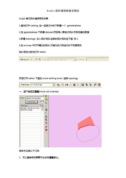
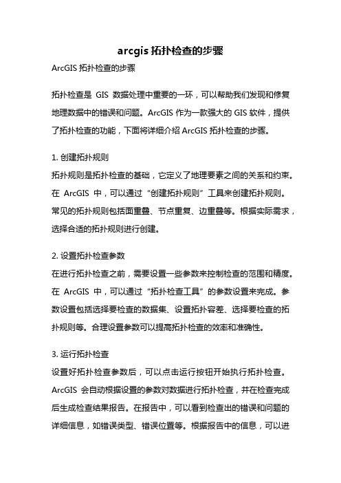
ArcGis拓扑错误检查及修改arcgis常见拓扑错误修改步骤1,首先打开catalog 在一目录文件夹下新建一个 geodatabase2,在gepdatabase下新建dataset,然后导入要进行拓扑关系检查的数据3,新建topology 加入拓扑规则,全部的拓扑规则在下面附14,在arcmap中打开建立的拓扑,对常见的几种进行如下附图修改拓扑修改之前先打开editor然后打开editor下面的more editing tools 选择topology一、面不能相互重叠(must not overlap)修改方法有以下几种:1、可以直接修改要素节点去除重叠部分。
2、在错误上右键选择merge,将重叠部分合并到其中一个面里。
二、面不能有缝隙(must not have gaps)1、可以直接修改要素节点去除重叠部分。
附11.must not overlay:单要素类,多边形要素相互不能重叠2.must not have gaps:单要素类,连续连接的多边形区域中间不能有空白区(非数据区)3.contains point:多边形+点,多边形要素类的每个要素的边界以内必须包含点层中至少一个点4.boundary must be covered by:多边形+线,多边形层的边界与线层重叠(线层可以有非重叠的更多要素)5.must be covered by feature class of:多边形+多边形,第一个多边形层必须被第二个完全覆盖(省与全国的关系)6.must be covered by:多边形+多边形,第一个多边形层必须把第二个完全覆盖(全国与省的关系)7.must not overlay with:多边形+多边形,两个多边形层的多边形不能存在一对相互覆盖的要素8.must cover each other:多边形+多边形,两个多边形的要素必须完全重叠9.area boundary must be covered by boundaryof:多边形+多边形,第一个多边形的各要素必须为第二个的一个或几个多边形完全覆盖10.must be properly inside polygons:点+多边形,点层的要素必须全部在多边形内11.must be covered by boundary of:点+多边形,点必须在多边形的边界上线topology1.must not have dangle:线,不能有悬挂节点2.must not have pseudo-node:线,不能有伪节点3.must not overlay:线,不能有线重合(不同要素间)4.must not self overlay:线,一个要素不能自覆盖5.must not intersect:线,不能有线交叉(不同要素间)6.must not self intersect:线,不能有线自交叉7.must not intersect or touch interrior:线,不能有相交和重叠8.must be single part:线,一个线要素只能由一个path组成9.must not covered with:线+线,两层线不能重叠10.must be covered by feature class of:线+线,两层线完全重叠11.endpoint must be covered by:线+点,线层中的终点必须和点层的部分(或全部)点重合12.must be covered by boundary of:线+多边形,线被多边形边界重叠13.must be covered by endpoint of:点+线,点被线终点完全重合14.point must be covered by line:点+线,点都在线上有若干专用术语相交(Intersect):线和线交叉,并且只有一点重合,该点不是结点(端点),称之相交。
ArcGis拓扑错误检查及修改
arcgis常见拓扑错误修改步骤1,首先打开catalog 在一目录文件夹下新建一个geodatabase2,在gepdatabase下新建dataset,然后导入要进行拓扑关系检查的数据3,新建topology 加入拓扑规则,全部的拓扑规则在下面附14,在arcmap中打开建立的拓扑,对常见的几种进行如下附图修改拓扑修改之前先打开editor然后打开editor下面的more editing tools 选择topology一、面不能相互重叠(must not overlap)修改方法有以下几种:1、可以直接修改要素节点去除重叠部分。
2、在错误上右键选择merge,将重叠部分合并到其中一个面里。
二、面不能有缝隙(must not have gaps)1、可以直接修改要素节点去除重叠部分。
2、在错误上右键选择create feature,将缝隙部分生成一个新的要素,然后利用editor下的merge把生成的面合并到相邻的一个面里。
3、task里选择auto-complete polygon,用草图工具自动完成多边形,会在缝隙区域自动生成两个多边形,然后用merge合并到相邻面里。
附11.must not overlay:单要素类,多边形要素相互不能重叠2.must not have gaps:单要素类,连续连接的多边形区域中间不能有空白区(非数据区)3.contains point:多边形+点,多边形要素类的每个要素的边界以内必须包含点层中至少一个点4.boundary must be covered by:多边形+线,多边形层的边界与线层重叠(线层可以有非重叠的更多要素)5.must be covered by feature class of:多边形+多边形,第一个多边形层必须被第二个完全覆盖(省与全国的关系)6.must be covered by:多边形+多边形,第一个多边形层必须把第二个完全覆盖(全国与省的关系)7.must not overlay with:多边形+多边形,两个多边形层的多边形不能存在一对相互覆盖的要素8.must cover each other:多边形+多边形,两个多边形的要素必须完全重叠9.area boundary must be covered by boundary of:多边形+多边形,第一个多边形的各要素必须为第二个的一个或几个多边形完全覆盖10.must be properly inside polygons:点+多边形,点层的要素必须全部在多边形内11.must be covered by boundary of:点+多边形,点必须在多边形的边界上线topology1.must not have dangle:线,不能有悬挂节点2.must not have pseudo-node:线,不能有伪节点3.must not overlay:线,不能有线重合(不同要素间)4.must not self overlay:线,一个要素不能自覆盖5.must not intersect:线,不能有线交叉(不同要素间)6.must not self intersect:线,不能有线自交叉7.must not intersect or touch interrior:线,不能有相交和重叠8.must be single part:线,一个线要素只能由一个path组成9.must not covered with:线+线,两层线不能重叠10.must be covered by feature class of:线+线,两层线完全重叠11.endpoint must be covered by:线+点,线层中的终点必须和点层的部分(或全部)点重合12.must be covered by boundary of:线+多边形,线被多边形边界重叠13.must be covered by endpoint of:点+线,点被线终点完全重合14.point must be covered by line:点+线,点都在线上有若干专用术语相交(Intersect):线和线交叉,并且只有一点重合,该点不是结点(端点),称之相交。
ArcGis拓扑错误检查及修改
arcgis常见拓扑错误修改步骤1,首先打开catalog 在一目录文件夹下新建一个geodatabase2,在gepdatabase下新建dataset,然后导入要进行拓扑关系检查的数据3,新建topology 加入拓扑规则,全部的拓扑规则在下面附14,在arcmap中打开建立的拓扑,对常见的几种进行如下附图修改拓扑修改之前先打开editor然后打开editor下面的more editing tools 选择topology一、面不能相互重叠(must not overlap)修改方法有以下几种:1、可以直接修改要素节点去除重叠部分。
2、在错误上右键选择merge,将重叠部分合并到其中一个面里。
二、面不能有缝隙(must not have gaps)1、可以直接修改要素节点去除重叠部分。
2、在错误上右键选择create feature,将缝隙部分生成一个新的要素,然后利用editor下的merge把生成的面合并到相邻的一个面里。
3、task里选择auto-complete polygon,用草图工具自动完成多边形,会在缝隙区域自动生成两个多边形,然后用merge合并到相邻面里。
附11、must not overlay:单要素类,多边形要素相互不能重叠2、must not have gaps:单要素类,连续连接的多边形区域中间不能有空白区(非数据区)3、contains point:多边形+点,多边形要素类的每个要素的边界以内必须包含点层中至少一个点4、boundary must be covered by:多边形+线,多边形层的边界与线层重叠(线层可以有非重叠的更多要素)5、must be covered by feature class of:多边形+多边形,第一个多边形层必须被第二个完全覆盖(省与全国的关系)6、must be covered by:多边形+多边形,第一个多边形层必须把第二个完全覆盖(全国与省的关系)7、must not overlay with:多边形+多边形,两个多边形层的多边形不能存在一对相互覆盖的要素8、must cover each other:多边形+多边形,两个多边形的要素必须完全重叠9、area boundary must be covered by boundary of:多边形+多边形,第一个多边形的各要素必须为第二个的一个或几个多边形完全覆盖10、must be properly inside polygons:点+多边形,点层的要素必须全部在多边形内11、must be covered by boundary of:点+多边形,点必须在多边形的边界上线topology1、must not have dangle:线,不能有悬挂节点2、must not have pseudo-node:线,不能有伪节点3、must not overlay:线,不能有线重合(不同要素间)4、must not self overlay:线,一个要素不能自覆盖5、must not intersect:线,不能有线交叉(不同要素间)6、must not self intersect:线,不能有线自交叉7、must not intersect or touch interrior:线,不能有相交与重叠8、must be single part:线,一个线要素只能由一个path组成9、must not covered with:线+线,两层线不能重叠10、must be covered by feature class of:线+线,两层线完全重叠11、endpoint must be covered by:线+点,线层中的终点必须与点层的部分(或全部)点重合12、must be covered by boundary of:线+多边形,线被多边形边界重叠13、must be covered by endpoint of:点+线,点被线终点完全重合14、point must be covered by line:点+线,点都在线上有若干专用术语相交(Intersect):线与线交叉,并且只有一点重合,该点不就是结点(端点),称之相交。
arcgis拓扑检查的步骤
arcgis拓扑检查的步骤ArcGIS拓扑检查的步骤拓扑检查是GIS数据处理中重要的一环,可以帮助我们发现和修复地理数据中的错误和问题。
ArcGIS作为一款强大的GIS软件,提供了拓扑检查的功能,下面将详细介绍ArcGIS拓扑检查的步骤。
1. 创建拓扑规则拓扑规则是拓扑检查的基础,它定义了地理要素之间的关系和约束。
在ArcGIS中,可以通过“创建拓扑规则”工具来创建拓扑规则。
常见的拓扑规则包括面重叠、节点重复、边重叠等。
根据实际需求,选择合适的拓扑规则进行创建。
2. 设置拓扑检查参数在进行拓扑检查之前,需要设置一些参数来控制检查的范围和精度。
在ArcGIS中,可以通过“拓扑检查工具”的参数设置来完成。
参数设置包括选择要检查的数据集、设置拓扑容差、选择要检查的拓扑规则等。
合理设置参数可以提高拓扑检查的效率和准确性。
3. 运行拓扑检查设置好拓扑检查参数后,可以点击运行按钮开始执行拓扑检查。
ArcGIS会自动根据设置的参数对数据进行拓扑检查,并在检查完成后生成检查结果报告。
在报告中,可以看到检查出的错误和问题的详细信息,如错误类型、错误位置等。
根据报告中的信息,可以进一步了解和分析数据中存在的问题。
4. 分析拓扑检查结果拓扑检查结果报告提供了详细的错误和问题信息,但需要进一步分析和处理。
在ArcGIS中,可以使用“错误检查工具”来对检查结果进行分析。
该工具可以对错误进行分类、过滤和排序,方便用户找到感兴趣的错误和问题。
通过分析拓扑检查结果,可以对数据进行有效的修复和改进。
5. 修复拓扑错误拓扑检查的目的是发现和修复地理数据中的错误和问题。
在ArcGIS 中,可以使用编辑工具来修复拓扑错误。
例如,对于面重叠的错误,可以使用“裁剪”或“合并”工具来修复;对于节点重复的错误,可以使用“删除”或“合并”工具来修复。
根据具体的错误类型,选择合适的编辑工具进行修复。
6. 重新运行拓扑检查修复拓扑错误后,需要重新运行拓扑检查来验证修复效果。
ARCGIS拓扑检查步骤(ARCGIStopologycheckstep)

ARCGIS拓扑检查步骤(ARCGIS topology check step)Start ArcCatlalog;Choose a local directory, "right click" - > "new" - > "create a personal personal GeoDatabase";Select the GeoDatabase just created "right click" - > "new" - > "data set dataset" coordinate system; data set, if you are not sure you choose to coordinate system analysis of data;Just select the created data set, "right click" - > "inport --feature class single import feature class, you need to import topology analysis data;Just select the created data set, "right click" - > "new" - > "topology", create topology, topology according to the prompts to create, add topological rules;Topology analysis.Finally, open the file generated by the topology rule in ArcMap, and use the error record information in the topolopy toolbar to modify itImport the data set into ARCMAP and edit it by clicking the edit button.Open the eidt drop-down menu, select the more editing Toolstopology appears topology editing toolbar.Select the data to topology, and click the error inspectorbutton.In the error inspector dialog box, click search now to find all topology errors.Mark as Exception for line errors.The polygon error checking, first select the wrong spot, right click to select zoom to, and then click merge, select the appropriate chart for merge treatment, so as not to lose the information class.[part one]In ArcGIS, about topolopy operations, there are two places, one in ArcCatalog and one in arcmap. Typically, we build topologies in ArcCatalog, called topology rules, and establish topologies in ArcMap, called topology processing.The topology creation rules provided in ArcCatalog are mainly for checking topological errors, some of which can be modified and adjusted within the limitation. After you set up the topology rules, you can open some topology rules in ArcMap and modify them according to the error hint.In the ArcMap topolopy toolbar the main function of the line topology (delete duplicate lines, the line of intersection point and so on, topolopy planarize lines), according to the line topology generation surface (topolopy construct features), the topology editor (such as shared edge edit etc.), topology error display (used for displaying the topology rules createdin ArcCatalog the error in error inspector in topolopy), re verification of topology error (i.e. refresh error records).[second part]Specific steps for creating topology rules in ArcCatalogTo create topology rules in ArcCatalog, you must ensure that the data is in the Geodatabase format and that the element classes that want to perform topological rule checking are set in the same set of elements.Therefore, first create a new Geodatabase, then create a collection of elements under it, and then create the element class or import the other data as the element class into the set of elements.Into the element set, right-click on the right margin of the window, new->topolopy in the pop-up right-click menu, and then follow the prompts and add some rules to complete the topology check.Finally, open the file generated by the topology rule in ArcMap, and use the error record information in the topolopy toolbar to modify it.[third part]Topology rules about GeodatabasePolygon topology1.must, not, overlay: single factor classes, polygon elements can not overlap each other2.must not have gaps: a single element class, a continuous connected polygon region, with no blank space in the middle (non data area)3.contains point: a polygon + point, within the boundary of each element of a polygon element class, must contain at least one point in the point layer4.boundary, must, be, covered, by: polygon + line,The boundary of the polygon layer overlaps with the line layer (the line layer can have more elements that are not overlapped)5.must, be, covered, by, feature, class, of: polygon + polygon, the first polygon layer must be completely covered by second (provinces, relationships with the whole country)6.must, be, covered, by: polygon + polygon, the first polygon layer must have second completely covered (national and provincial)7.must, not, overlay, with: polygon + polygon, polygon of two polygons can not exist a pair of elements covered by each other8.must, cover, each, other: polygon + polygon, the elements of the two polygons must overlap completely9.area boundary, must, be, covered, by, boundary, of,: polygon + polygon, each element of the first polygon must be completely covered by one or more polygons10.must, be, properly, inside, polygons: dot + polygon, the elements of the dot layer must all be inside the polygon11.must, be, covered, by, boundary, of: points + polygons, points must be on the boundary of the polygonLine topology1.must not have Dangle: line cannot have dangling nodes2.must, not, have, pseudo-node: line, cannot have pseudo node3.must, not, overlay: lines cannot be wired together (between different elements)4.must, not, self, overlay: lines, an element that cannot be self covered5.must not intersect: lines cannot be wired across (between different elements)6.must, not, self, intersect: line, cannot be wired self intersection7.must, not, intersect, or, touch, interrior: lines cannot intersect and overlap8.must be single part: line, a line element, can only be made up of one path9.must, not, covered, with: line + line, two lines cannot overlap10.must, be, covered, by, feature, class, of: lines + lines, two layers of lines overlap completely11.endpoint must be covered by: line + point, the end point in the line layer must coincide with the partial (or all) points of the point layer12.must, be, covered, by, boundary, of: lines + polygons, lines overlap by polygon boundaries13.must, be, covered, by, endpoint, of: dot + line, the point is completely coincident with the line end14.point, must, be, covered, by, line: points + lines, points are online[fourth part]Geodatabase organizational structure.In Geodatabases, geographic data is organized into a data objects. These data objects are stored in the element class (feature, class), the object class (object class), or the feature datasets.The object class (object class) is used to store non spatial information.The class (feature) stores spatial information and its corresponding attribute information. In the same element class, the geometry of the spatial elements must be consistent, such as points, lines, or faces. In short, a factor class is a collection of similar elements.The dataset (feature) is used to store the class of elements with the same spatial reference (spatial, reference). The class of elements that store simple elements can be stored in the element set, or can be stored directly in the Geodatabase directory as a single element class. The class of elements directly stored in the Geodatabase directory is also called feature (standalone). The element classes of the storage topology must be stored in the factor set, and the purpose of the use of the set of elements is to ensure that these elements have a uniform spatial reference to facilitate maintenance of the topology. Geodatabase supports logical integrity between the elements classes, which is represented by support for complex networks (complex, networks), topology rules, and relational classes. The following describes the data object in Geodatabase (data, objects).Element class (Feature, class)A class of elements can be called a collection of elements of a point, line, or surface, and at the same time, the text information of a map can be stored in the annotation element class. A class of non independent elements, that is, theassociated element classes, such as those that participate in topological rules or geometric networks, are managed together in the form of a set of elements.Raster data set (Raster, data, set)Raster data of single or multiple bands managed in raster tables.Table (Tables)A table describing non spatial information.Association class (Relationships)An association class is a mechanism that selects records from a table (element class) and then gets the corresponding records in the associated table (element class).Domain (Domains)A list (or range) of column valid values.Subclass (Subtypes)The elements in the element class are logically grouped, each grouping being a subclass. Each of these has its integrity, rules, and GIS behavior (such as freeways, which are a subset of road elements).Spatial relations (Spatial, relationships)Defined in a topology tool (topologies) or a geometric network (Geometric, network). What rules can topological spatial relationship between the elements specified in the class, such as land cannot overlap (overlap), or a plurality of spatial relationships between different elements in the class of elements, such as the national capital (elements) must be located in the national territory (factor).A description document of each element in a metadata (Metadata) database.。
ARCGIS拓扑检查步骤

启动ArcCatlalog;任意选择一个本地目录,"右键"->"新建"->"创建个人personal GeoDatabase";选择刚才创建的GeoDatabase,"右键"->"新建"->"数据集dataset";设置数据集的坐标系统,如果不能确定就选择你要进行分析的数据的坐标系统;选择刚才创建的数据集,"右键"->"导入要素类inport --feature class single",导入你要进行拓扑分析的数据;选择刚才创建的数据集,"右键"->"新建"->"拓扑",创建拓扑,根据提示创建拓扑,添加拓扑处理规则;进行拓扑分析。
最后在arcmap中打开由拓扑规则产生的文件,利用topolopy工具条中错误记录信息进行修改将数据集导入ARCMAP中,点击edit按钮进行编辑。
打开eidt下拉菜单,选择more editing tools--topology出现拓扑编辑工具栏。
选择要拓扑的数据,点击打开error inspector按钮。
在error inspector对话框中点击search now,找出所有拓扑的错误。
对线状错误进行Mark as Exception。
对polygon错误逐个检查,首先选择错误的小班,点击右键选择zoom to,然后点击merge,选择合适的图班进行merge处理,这样不会丢失小班信息。
【第一部分】在arcgis中有关topolopy操作,,有两个地方,一个是在arccatalog中,一个是在arcmap 中。
通常我们将在arccatalog中建立拓扑称为建立拓扑规则,而在arcmap中建立拓扑称为拓扑处理。