航海类(甲类)三副-《航海学》历届真题第38期
甲类三幅 航海英语历届真题考题答案及翻译31--48综述
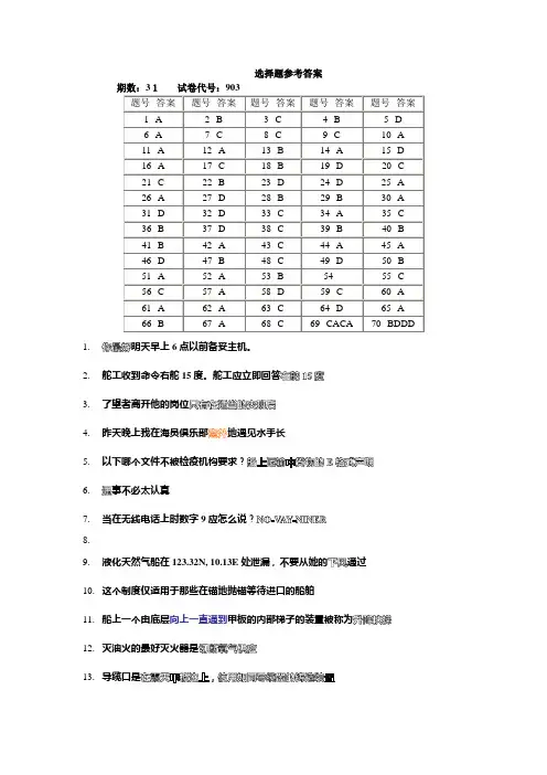
选择题参考答案1.明天早上6点以前备妥主机。
2.舵工收到命令右舵15度。
舵工应立即回答3.了望者离开他的岗位4.昨天晚上我在海员俱乐部地遇见水手长5.以下哪个文件不被检疫机构要求?6.事不必太认真7.当在无线电话上时数字9应怎么说?8.9.液化天然气船在123.32N, 10.13E处泄漏,不要从她的通过10.这个制度仅适用于那些在锚地抛锚等待进口的船舶11.船上一个由底层向上一直通到甲板的内部梯子的装置被称为12.灭油火的最好灭火器是13.导缆口是14.泡沫灭火通过15.为了使管道系统内部发生燃烧,如海上喷射系统中的气体收集头必须有16.火灾的对流蔓延由来完成17.你船迅速下沉。
一个装有可膨胀式救生筏的箱子连接在静水力释放装置上。
你应采取什么措施?18.在船舶管理中被要求的消防演习中,所有人员必须报告它们的位置和模拟指派给他们的任务完成的能力19.你应怎样指挥起货机手提升吊杆?20.去年我们已对起货机做了21.明天早晨下雨,装货22.自由液面的增加致使的上升23.对于任何基座式起重机,当其吊杆被延长时,则其起重能力被24.谷糠,煤之类的货物,必须通风以它们自燃25.表明船舶的初稳性26.在每年的这个季节里,上面提及的区域能见度27.船舶志中的所有记录必须(被)由船长和一名船员签字28.具有红绿横纹的浮筒将具有的灯光特性29.无论何处可能获得好锚地,通常是泥和沙,在这些水域船舶可以拥有30.以下哪项不需要记入航海日志中?31.有时船舶在开敞锚地抛双锚锚泊以32.自西边开来的船舶将在位置015108N/1033008E引水员33.一双车船使用双车前进掉头,将更易于向右舷掉头假如34.在站点附近可能有海图上未注明的灯,雾号和雷达信标发射器35.潮水怎样?什么潮水36.建议你的渔网37.当一特定气团的温度上升时,38.悬式(干湿球)湿度计是一个39.对于气象传真图上标绘的信息,我们能够40.据预报,过几天大雨泛滥淹没港口及附近地区41.高压脊自Sevastopol到Libya东部42.12小时大风警告有效自1103900700UTC这句子,警告预报的有效期从开始43.在很多情况下,大洋水域的小比例尺海图的水文资料仍,所标水区的位置,水深和范围可能有误44.关于助航设施的严重缺陷或重要变化,首先通过给航海者45.长能够从任何的英版海图供应商那里获得英版航海通告46.平均高潮是的平均值47.任何国家的船舶均无线电医疗咨询服务并且这项服务不收费48.海图通过发布的信息而被改正49.一般地,用于画大洋航线,用于港口,内陆水域和沿岸区域50.闪(2)5秒的红色立杆灯标代替搁浅船西南方向附近的绿色锥型灯标。
航海类(甲类)三副-《航海学》历届真题第38期
中华人民共和国海事局2005年第3期海船船员适任证书全国统考试题(总第38期)科目:航海学试卷代号:9131. 纬度是以_____作为基准线计量的。
A. 赤道B. 等纬圈C. 格林经线D. 测者经线2. 每年12月22日,对于纬度10°N的测者来说太阳中天高度和方位各为:A.H=76°33′;A=0°B.H=56°33′;A=0°C.H=56°33′;A=180°D.H=76°33′;A=180°3. 已知到达点纬度为30°11'.8N,两地间纬差为 38°07'.8N,则起航点纬度为:A. 20°19'.6NB. 08°04'.0NC. 07°56'.0SD. 08°04'.0S4. 天体圆周方位为310°,测者纬度为10°N,化为半圆方位应为:A. 10°NEB.130°SWC.50°NWD.130°SE5. 罗经点方向SW/S换算成圆周方向为:A. 258°.75B. 236°.25C. 213°.75D. 191°.256. 测者南北线是由什么面确定的?A. 测者真地平平面与测者子午圈平面B. 测者真地平平面与测者卯酉圈平面C. 测者地面真地平平面与测者子午圈平面D. 测者地面真地平平面与测者卯酉圈平面7. 某船真航向300°,测得某物标真方位350°,则该物标的相对方位(舷角)为:A. 350°B. 50°右C. 50°左D. 290°右8. 有A、B二张墨卡托图,A图上10 N纬线到赤道的子午线图长为601.5mm,B图上10 N纬线到赤道的子午线图长为621mm,则两图的基准比例尺:A.A图一定比B图大B.B图一定比A图大C.A图与B图相等D.视两图的基准纬度而定9. 某船真航向120°,该船右正横某物标的真方位为:A. 210°B. 30°C. 030°D. 090°10. 某地磁差资料为:Var. 0°40'W(1979),increase about 2'.5 annually,则该地1999年的磁差为:A. 1°05'WB. 0°15'WC. 1°30'WD. 0°10'E11. 若已知某轮罗航向CC=000°,磁差Var=2°W,罗经差ΔC=1°W,则该轮真航向为:A. 357°B. 359°C. 001°D. 003°12. 1月6日区时0350,船舶位于经度等于66°20′E处,则世界时为:A.2250 5/1B.2350 5/1C.0750 6/1D.0850 6/113. 航海上,公式D O(n mile)=2.09e+2.09H是用于计算:A.测者能见地平距离B.物标能见地平距离C.物标地理能见距离D.雷达地理能见距离14. 某轮由45°N纬线向北航行,无航行误差,计程仪改正率为0.0%,则1h后实际船位位于推算船位的(不考虑风流影响):A. 北面B. 南面C. 同一点D. 不一定15. 某船沿赤道航行,已知计程仪改正率0.0%,无航行和推算误差,则在海图上按计程仪航程推算的船位比实际船位(不考虑风流影响):A. 超前B. 落后C. 一致D. 不一定16. 天球上的仰极是:A. 天极B. 天北极C. 天南极D. 与测者纬度同名的天极17. 过两天极且通过_____的半个大圆称为测者午圈。
第38期海船船员适任证书统考试卷及答案驾驶专业
中华人民共和国海事局2005年第3期海船船员适任证书全国统考试题(总第38期)科目:航海英语试卷代号:903适用对象:无限航区、近洋航区二/三副(本试卷卷面总分100分,及格分为70分,考试时间100分钟)答题说明:请选择一个最合适的答案,并将该答案按答题卡要求,在相应位置上用2B铅笔涂黑.第1题至68题,每题1分,第69题至76题,每题4分.一.单项选择题1.Hard right rudder means ______.A.jam the rudder against the stopsB.meet a swing to the right,then return to amidshipsC.put the rudder over to the right all the wayD.put the rudder over quickly to 15 degrees right rudder2.It is dangerous for vessels without the use of radar ______ the estuary.A.to get B.to approach C.to proceed D.to close3.Get searchlight ______ for transiting the canal at night.A.on B.already C.ready D.almost4.Go and ______ your Shipper to my cabin.A.take B.bring C.fetch D.carry5.Allow me to put ______ some evidence for your further consideration.A.up B.on C.into D.forward6.Many new ______ will be opened up at sea in the future for those with a university education.A.opportunities B.realities C.necessities D.probabilities7.Of the following,_______ means the sufficiency of a vessel in materials,construction,equipment,crew,and outfit for the trade or service in which it is employed.A.Seaworthiness B.Cargo-worthiness C.Readiness D.Proficiency 8.The following ______ is a standard phrase.A.WARNING.Y ou are running into dangerB.Y ou are possibly running into dangerC.Y ou could be in the case of running into dangerD.Y ou could,I think,be running into danger9.The following ______is a standard phrase.A.Y ou may enter fairway B.Y ou should enter fairwayC.ANSWER.It is permitted to enter fairway D.Y ou could enter fairway10.The turning circle of a vessel is the path followed by the ______.A. center of gravityB. outermost part of the ship while making the circleC.bowD. tipping center11.Which of the following best indicates how many tons of cargo a ship can carry?A.Bale cubic B.Deadweight C.Gross tonnage D.Net tonnage 12.Ships are also required to carry a(n) _______ to mitigate the effects of environmental damage in the event of a pollution incident by ISM code and MARPOL convention.A. Oil Record BookB. Cargo Record BookC. Muster ListD. Shipboard Oil Pollution Emergency Plan13.Foam extinguishes a fire by ______.A.shutting off the air supply B.cooling the fuel to below ignition temperature C.dispersing(使分散) the fuel D.removing the source of ignition14.Most propellers on merchant vessels are constructed of_____.A.manganese bronze B.cast iron C.mild steel D.improved plow steel 15.Damage to ship’s fittings caused by stevedore's negligence often happens.Therefore,the stevedores ______ the cost of the damage repaired afterwards.A.should hold responsible for B.should be held responsible forC.should be free of D.should be bearable of16.Y our vessel is equipped with totally enclosed lifeboats.Which statement is TRUE when the boat is enveloped in flames?A.The ventilators will automatically close by the action of fusible linksB.The motor takes its air supply from outside the lifeboat to prevent asphyxiation(窒息)of the crewC.A water spray system to cool the outside of the boat is operated by a high-volume manual pumpD.An air tank will provide about ten minutes of air for the survivors and the engine17.A fire starts on your vessel while refueling.Y ou should FIRST ______.A.stop the ventilation B.sound the general alarmC.determine the source of the fire D.attempt to extinguish the fire18.At the required fire drill conducted aboard a vessel,all persons must report to their stations and demonstrate their ability to perform the duties assigned to them ______.A.by the tool pusher B.in the station billC.by the person conducting the drill D.at the previous safety meeting19.The difference in tones between the displacement in salt water at summer load waterline and the light weight of the vessel is ______.A.deadweight B.gross tonnage C.net tonnage D.displacement 20.By regulation,cargo tanks must be inert before and during what operation?A.Stripping B.Loading C.Cleaning D.Crude oil washing 21.Y ou should do a ______ check to all of the cargo before shipment.A.though B.through C.thorough D.thoroughly 22.Chafing gear(防摩擦装置)is used to ______.A.anchor the boat B.pick up heavy loadsC.protect fiber rope from abrasion D.strengthen mooring lines23.TO EV ACUA TE A VESSEL FROM CREW AND PASSENGERS FOLLOWING A DISTRESSmeans ______.A. abandon vesselB. adriftC. beach toD. assembly station 24.THROWING OVERBOARD OF GOODS IN ORDER TO LIGHTEN THE VESSEL OR IMPROVE ITS STABILITY IN CASE OF AN EMERGENCY defines ______.A. Dropping offB. JettisonC. Throwing awayD. Taking off 25.A safe pilot transfer operation relies on greatly the following except ______.A. lighting at night timeB. the number of the crewmembersC. lifebuoy with self-igniting lightD. VHF communication with bridge26.In radar plotting ,CPA is the abbreviation of ______.A.closest point to approach B.close point to approachC.crossing point to approach D.coming point to approach27.The ship ______ the Atlantic to America next week.A.shall cross B.shall cross to C.cross D.sail cross28.______ means the curve on the earth's surface which cuts all the meridians at the same angle.A.Great Circle B.Position Line C.Rhumb line D.True Bearing29.It is sometimes necessary to moor bow and stern to two mooring buoys in order to ______.A.avoid any swing in a restricted space B.shelter the ship from strong windsC.prevent to touch with other vessels D.make a convenience of cargo discharging 30.We ______ at anchor in the roadstead till the evening.A.have to ride B.have to get C.have to put D.have to make31.A vessel moored with two anchors,sometimes,at an exposed roadstead to ______.A.aid turning the ship B.obtain a fine bearingC.increase ship swings to wind or tide D.lighten the stress of anchor chains32.Every ship should hoist ______ when approaching and entering ports.A.its flashing light B.the ship's name C.its identification D.its signal letters 33.For working details ______ Admiralty list of Radio SignalA.refer B.see C.watch D.look34.In relation to the turning circle of a ship,the term advance means the distance ______.A.gained at right angles to the original courseB.gained in the direction of the original courseC.moved sidewise from the original course when the rudder is first put overD.around the circumference of the turning circle35.I have steerage way.It is said that ______.A.I am underwayB.I am out of controlC.I am not making way through the waterD.I have the amount of movement forward which the ship needs to be steered properly36.V essels are warned ______ in the area enclosed by pecked lines owing to the existence of numerous telegraph cables.A.anchor B.to anchor C.not to anchor D.not to anchoring 37.Plain language is usually used on marine weather ______.A.forecasts B.observations C.analyses D.reports38.As the temperature of an air mass decreases,the ______.A.absolute humidity(湿度)decreases B.relative humidity increasesC.specific humidity decreases D.dew point rises39.In the Northern Hemisphere,gusty winds shifting clockwise,a rapid drop in temperature,thunderstorms or rain squalls in summer (frequent rain/snow squalls in winter) then a rise in pressure followed by clearing skies,indicate the passage of a(n) ______A.warm front B.tropical cyclone C.anticyclone D.cold front 40.A generally circular low pressure area is called a(n) ______.A.cyclone B.anticyclone C.cold front D.occluded front 41.LOW A T 34N 135E ESLY SLWLY INTST NC.This description is most likely to be under the heading of ______.A.GL WNG B.GEN SYN C.STM WNG D.T Y WNG 42.MAINLY GOOD BECOMING MODERA TE.This forecast probably refers to ______ in a certain area.A.visibility B.winds C.sea D.fog43.A shipper of cargo aboard your vessel offers a letter of indemnity for the cargo.This is done in order to obtain a(n) ______.A.clean Bill of Lading B.order Bill of LadingC.straight Bill of Lading D.through Bill of Lading44.No navigational aids are shown and chart is not kept corrected for alterations in depths inside the pecked lines.For more detailed information,the larger scale charts must be ______.A.bought B.analyzed C.consulted D.published45.In revised editions of Admiralty charts the ______ are corrected first.A.smaller scales B.larger scalesC.smaller scales and larger scales D.moderate scales46.A radio medical advice service ______ ships of all nationalities and no charge is made for this service.A.is available to B.is available for C.are available to D.are available for 47.One of the principal dangers inherent in liquefied petroleum gas is that ______.A.as it warms up it becomes heavier than air B.the way it reacts with sea waterC.its low temperature causes frostbite or freezing D.the strong odor it produces 48.Sailing directions are kept up to date by ______.A.publications B.notices to marinersC.supplements D.Annual Summary of Admiralty Notices to Mariners49.All events relating to navigation,such as ship's position,speed and details of the weather,are recorded in ______.A. LogbookB. Bell BookC. Oil Record BookD. Compass Error Book 50.A chart has extensive corrections to be made to it. When these are made and the chart is againprinted,the chart issue is a _______.A. first editionB. new editionC. revised editionD. reprint 51.Deviation is the angle between the ______.A.true meridian and the axis of the compass cardB.true meridian and the magnetic meridianC.magnetic meridian and the axis of the compass cardD.axis of the compass card and the degaussing meridian52.In which voyage,between two points,is the rhumb line distance NOT approximately the same as the great circle distance?A. The two points are in low latitudes in the same hemisphereB. The two points are in high latitudes in the same hemisphereC. The two points are near the equator,but in different hemispheresD.One point is near the equator,one point is in a high latitude,and both are near the180th meridian53. Do not _____the watch to the relieving officer until he has verbally expressed his acknowledgment of the information which has been passed by the officer handing over.A.turn over B.hand over C.take over D.hands off54.Charted depth is the ______.A. vertical distance from the tidal datum to the ocean bottom plus the height of the tide.B. vertical distance from the tidal datum to the ocean bottomC. average height of water over a specified period of timeD. average height of all low waters at a place55.Mariners proceeding across the main routes are recommended to do so at ______.A.as wide an angle as practicable B.as wide an angle so practicableC.like wide an angle as practicable D.like wide as angle so practicable56.A relative bearing is always measured from ______.A. true northB. magnetic northC. the vessel's beamD. the vessel's head 57.It may be found that,in certain circumstances,radar beacon emissions can cause ______ with the normal radar display,particularly at close range.A.unwanted interference B.unexpected figuresC.abnormal data D.unwanted information58.Radar display in which North is always at the top of the screen is a(n) ______.A.unstabilized display B.stabilized displayC.composition display D.relative display59.Refer to STCW 95: Despite the duties and obligations of pilots, their presence on board does not relieve ______in charge of the navigational watch from their duties and obligations for the safety of the ship.A.the master B.the master or officer C.quarter master D.helmsman 60.The purpose of the voyage and passage plan is to ensure that navigation is planned in adequate detail with contingency plans where appropriate to ensure safety navigation throughout the intended voyage from ______.A.anchorage to anchorage B.pilot station to pilot stationC.berth to berth D.berth to pilot station61.One of the two systems established by GMDSS for the transmission and automatic receipt of Maritime Safety Information is ______.A.Initial Distress Alerts service B.Navigational Warning serviceC.INMARSA T Safety Net service D.Meteorological Warning service62.Y our vessel is equipped with a fixed CO2 system and a fire main system. In the event of an electrical fire in the engine room what is the correct procedure for fighting the fire?A. Use the CO2 system and evacuate the engine roomB. Use the fire main system and evacuate the engine roomC. Evacuate the engine room and use the CO2 systemD. Evacuate the engine room and use the fire main system63.______ is the process by which the position of the vessel at any moment is found by applying the last well-determined position to the run that has been made since,using for this purpose the ship's course and the distance being those indicated by log.A.Dead reckoning B.Dead weight C.Dead slow ahead D.Dead slow astern 64.We'll see ______ the compasses are in good condition.A.if B.how C.when D.where65.Y our ship is steaming at night with the gyropilot engaged.Y ou notice that the vessel's course is slowly changing to the right.Which action should you take FIRST?A.Notify the engine room of the steering malfunctionB.Change to hand steeringC.Call the MasterD.Send the Quartermaster to the emergency steering station66.A vessel restricted in her ability to maneuver is one which ______.A.through some exceptional circumstance is unable to maneuver as required by the RulesB.from the nature of her work is unable to maneuver as required by the RulesC.due to adverse weather conditions is unable to maneuver as required by the RulesD.has lost steering and is unable to maneuver67.If your vessel is the stand-on vessel in a crossing situation ______.A. you must keep your course and speedB. you may change course and speed as the other vessel must keep clearC. the other vessel must keep her course and speedD. both vessels must keep their course and speed68. Every vessel which is directed by these Rules to keep out of the way of another vessel shall,if the circumstances of the case admit,avoid _______.A. crossing ahead of the otherB. crossing astern of the otherC. passing port to portD. passing starboard to starboard二.关联题(每组关联题题干下有4个小题,每小题4个选项)第一组:While every effort is made to ensure that the data provided through the Notices to Mariners service is accurate, the user needs to be aware of the risks to corruption of data. It is important that the user should only use the data on suitable equipment and that, other applications should not be running on the user’s machine at the same time. Users should exercise their professional judgement in the use of data, and also consult the Mariners Handbook (NP100) for further details. The user needs to be aware that there is a possibility that data could be corrupted during transmission, or in the process of display or printing on the user’s equipment, or if converted to other software formats, and is accordingly advised that the UKHO cannot accept responsibility for any such change, or any modifications or unauthorised changes, made by licensees, or other parties.69.The data may become corrupted in any of the following process except _______.A. during transmissionB. in the display or printing on the user’s equipmentC. in converting to other software formatsD. in air mail delivery to the readers70.The use of the data is advised to consult _______ for further details.A. Mariners HandbookB. Sailing DirectionsC. Guide to Port EntryD. Notices to Mariners71.Of the following items _______ is not mentioned for which UKHO will accept no responsibility.A. change in the process of display or printingB. unauthorised changes made by licensees or other partiesC. modifications made by licensees or other partiesD. professional amendments.72.It is implied that _______.A. the data are incorrectB. the data are to be corrected intensivelyC. although the data are accurate enough, you are still advised to use it with cautionD. not to use it if you have not enough time or proper equipment to effect necessary correction 第二组:At about 0355, the second mate ended his radio conversation and went to the chart table to write up the log. With the second mate apparently busy, the seaman on watch attempted to identify the lights on the other vessel. When he returned to the bridge front, he suddenly saw a mast, with lights on it, passing extremely close to the starboard side and called out in alarm to the second mate. The second mate immediately engaged manual steering and applied 15° of port rudder. The seaman went to the starboard bridge wing from where he saw a vessel about two ship lengths astern. The second mate and the seaman had apparently not heard or felt any impact and they assumed that the other vessel had passed clear. The second mate heard the fishing vessel’s calls to the ship on VHF, but he did not acknowledge them. He also heard its communications with Brisbane Radio, but he did not respond. About 0750, the agent of the ship had been informed by the Brisbane harbour master that the ship had been in a collision with the fishing vessel.73.There were _______ persons on the bridge when the accident occurred.A. 1B. 2C. 3D. 474.It is inferred that the 2/O was _______ when the close quarter situation was developing.A. talking over VHF with the fishing shipB. not keeping a proper lookout, and allowed himself to be distracted by his radio conversationwith his friendC. engaging himself in other things which are more urgent at the momentD. keeping a proper lookout but failed to identify the fishing ship75.It can be concluded that ______.A. the two ships did not collided each otherB. the two ships collided each other, but none of them acknowledged the accidentC. only the fishing ship acknowledged the accident at the momentD. only the big ship acknowledged the accident at the moment76.Of the following, ______ is not likely to be the contributing factor of the accident.A. the second mate was not keeping a proper look out at the momentB. the seaman did not report to 2/O what he sawC. the fishing ship was not keeping a proper look out at the momentD. in the night it was too dark or too difficult for the crew members to identify each other。
航海天文学真题汇总有答案
41—49期甲类三副航海天文学真题汇总41期1、天文三角形的三边分别是 ______。
A. 高度、赤纬和时角B. 极距、顶距和余纬C. 高度、方位和位置角D. 天赤道、垂直圈和时圈2、当天体通过 ______时,其高度变化最慢。
A. 天赤道B. 真地平圈C. 测者子午圈D. 东西圈3、下述正确的说法是 ______。
A. 每一季节内测者所见的全部星空称为该季星空B. 经度不同的测者所见的“四季星空”也不相同C. “四季星空”是指测者在同一季节每天22点左右所见的星空D. “四季星空”是指测者在同一季节每天4点左右所见的星空4、以太阳的周日视运动的周期作为时间的计量单位得到 ______。
A. 恒星时B. 视时C. 平时D. 协调世界时5、 ______作为该时区的区时。
A. 时区边界的地方平时B. 世界时C. 平时D. 时区中线的地方平时6、世界各国标准时可由______查得。
A. 中版《航海天文历》B. 天体高度方位表C. 英版《无线电信号表》第二卷法定时部分D. 航海表7、潮差最大的潮汐称为 ______。
A. 分点潮B. 回归潮C. 大潮D. 小潮8、从潮信表查得某海区的平均高潮间隙MHWI为1125,则5月20日(农历十一)的高潮潮时约为_____。
A. 1101;2325B. 1125;2349C. 0725;1949D. 0625;19009、某地当日潮汐资料为:0600;500cm, 1200;100cm,则0800潮高为 ______。
A. 400cmB. 300cmC. 200cmD. 100cm10、英版潮汐潮流中,关于流速前正、负号的说法中正确的是 ______。
A. 正号一般代表落潮流向B. 负号一般代表涨潮流向C. 正负号代表的具体流向在表中有说明D. 正负号和流向无关11、半日潮港,涨潮流箭矢上标注2kn,则该处大潮日涨潮流第三小时内的平均流速为 ______。
A. 2/3knB. 4/3knC. 8/3knD. 2kn12、天体真出没是指 ______的瞬间。
海船三副评估试题及答案
海船三副评估试题及答案无限/近洋/沿海航区3000总吨及以上船舶二/三副航海技术教研室2005年12月8日目录一、货物积载与系固 (1)二、航线设计 (17)三、海图作业 (29)四、船舶定位 (40)五、测罗经差 (57)六、航海仪器的正确使用 (65)一、货物积载与系固无限/近洋/沿海航区3000总吨及以上船舶二/三副编号: O-gen-1编码:JF211评估时间:180分钟评估方式:实操评分标准:本卡总分50分题目:编制杂货船的配积载计划“Q”轮第V0095W航次货运任务如下列“装货清单”所列。
船舶计划于月日在上海港装货后开航。
全航程中船舶吃水无水深限制,船舶航速17.5 kn,船舶在始发港补足油水,无中途油水补给计划。
船舶各液舱油水等储备量见“答题卷”中表 - 5,“Q”轮其他详细资料见教材。
装货清单Loading List of S.S/M.V "Q"编号: O-gen-2编码:JF212评估时间:180分钟评估方式:实操评分标准:本卡总分50分题目:编制杂货船的配积载计划“Q”轮第V0096W航次货运任务如下列“装货清单”所列。
船舶计划于月日在上海港装货后开航。
全航程中船舶吃水无水深限制,船舶航速17.5 kn,船舶在始发港补足油水,无中途油水补给计划。
船舶各液舱油水等储备量见“答题卷”中表 - 5,“Q”轮其他详细资料见教材。
装货清单Loading List of S.S/M.V "Q"编号: O-gen-3编码:JF213评估时间:180分钟评估方式:实操评分标准:本卡总分50分题目:编制杂货船的配积载计划“Q”轮第V0097W航次货运任务如下列“装货清单”所列。
船舶计划于月日在上海港装货后开航。
全航程中船舶吃水无水深限制,船舶航速17.5 kn,船舶在始发港补足油水,无中途油水补给计划。
船舶各液舱油水等储备量见“答题卷”中表 - 5,“Q”轮其他详细资料见教材。
船员三副考试题目及答案
船员三副考试题目及答案一、单项选择题(每题2分,共20分)1. 船舶在航行中,三副负责的主要职责不包括以下哪一项?A. 协助船长管理船舶安全B. 负责船舶货物的装卸C. 协助大副进行船舶日常维护D. 管理船舶的消防和救生设备答案:B2. 根据国际海事组织(IMO)的规定,船舶在哪个阶段必须进行消防演习?A. 每次航行前B. 每三个月至少一次C. 每六个月至少一次D. 每年至少一次答案:C3. 船舶在遇到海盗袭击时,三副应立即采取的行动是什么?A. 立即向船长报告情况B. 组织船员进行自卫C. 启动船舶的反海盗预案D. 以上都是答案:D4. 船舶在航行中遇到恶劣天气,三副应如何协助船长?A. 提供气象信息B. 协助调整航向和航速C. 检查船舶的密封性D. 以上都是答案:D5. 船舶在进行货物装卸作业时,三副需要检查哪些安全设备?A. 救生设备B. 消防设备C. 货物装卸设备D. 以上都是答案:D6. 船舶在国际水域遇到紧急情况时,三副应如何协助船长?A. 协助船长与相关国家或组织联系B. 协助船长制定紧急应对措施C. 组织船员进行紧急撤离演练D. 以上都是答案:D7. 船舶在进行日常维护时,三副需要检查哪些设备?A. 导航设备B. 通信设备C. 动力设备D. 以上都是答案:D8. 船舶在航行中遇到船舶碰撞事故,三副应立即采取的行动是什么?A. 立即向船长报告情况B. 组织船员进行应急处置C. 检查船舶的损害情况D. 以上都是答案:D9. 船舶在进行消防演习时,三副需要检查哪些设备?A. 消防泵B. 灭火器C. 消防水带D. 以上都是答案:D10. 船舶在进行救生演习时,三副需要检查哪些设备?A. 救生艇B. 救生筏C. 救生衣D. 以上都是答案:D二、多项选择题(每题3分,共15分)1. 船舶在航行中,三副需要负责的安全管理工作包括哪些?A. 船舶的安全航行B. 船舶的消防和救生设备的检查C. 船舶的货物装卸安全D. 船舶的环境保护答案:A、B、C、D2. 船舶在遇到海盗袭击时,三副需要采取的措施包括哪些?A. 立即向船长报告情况B. 启动船舶的反海盗预案C. 组织船员进行自卫D. 与相关国家或组织联系答案:A、B、C、D3. 船舶在进行消防演习时,三副需要检查的设备包括哪些?A. 消防泵B. 灭火器C. 消防水带D. 消防警报系统答案:A、B、C、D4. 船舶在进行救生演习时,三副需要检查的设备包括哪些?A. 救生艇B. 救生筏C. 救生衣D. 救生信号设备答案:A、B、C、D5. 船舶在进行日常维护时,三副需要检查的设备包括哪些?A. 导航设备B. 通信设备C. 动力设备D. 安全设备答案:A、B、C、D三、判断题(每题1分,共10分)1. 船舶在航行中,三副不需要负责船舶货物的装卸。
甲类三副海事局考题
编号:1编码:JB1001评估时间:不超过60分钟评估方式:1、实操2、实操评分标准:本卡总分60分,设计航线一条40分,合计满60分及格题目:1、抽选Shanghai(上海)到Singapore(新加坡)港的海图及图书资料并检验由评估员指定的某海图及图书是否适用;2、用Ocean Passage for the Wold一书查取Shanghai(上海)到Vanconver(温哥华)港的推荐航线,并利用相关资料对Ocean Passage for the Wold一书进行改正。
编号:2编码:JB1002评估时间:不超过60分钟评估方式:1、实操2、实操评分标准:本卡总分60分,设计航线一条40分,合计满60分及格题目:1、抽选Shanghai(上海)到Vanconver(温哥华)港的海图及图书资料并检验由评估员指定的某海图及图书是否适用;2、用提供的ALRS查—雷达航标(Radar Beacon)的具体资料后解释其含义,并利用相关资料对某一雷达航标资料进行改正。
编号:3编码:JB1003评估时间:不超过60分钟评估方式:1、实操2、实操评分标准:本卡总分60分,设计航线一条40分,合计满60分及格题目:1、抽选Shanghai(上海)到San Francisco(旧金山)港的海图及图书资料并检验由评估员指定的某海图及图书是否适用;2、用提供的ALRS查panama港的标准时间及日光节时间(夏令时),并利用相关资料对某一雷达航标资料进行改正。
编号:4编码:JB1004评估时间:不超过60分钟评估方式:1、实操2、实操评分标准:本卡总分60分,设计航线一条40分,合计满60分及格题目:1、抽选Aden(亚丁)到Singapore(新加坡)港的海图及图书资料并检验由评估员指定的某海图及图书是否适用;2、用ALRS查汉堡(HAMBURO)港有关引航和港口服务的信息,并利用相关资料对引航服务资料进行改正。
甲类三副“航线设计”题目及答案
等级:无限航区船舶二/三副项目:航线设计编号:JB1001~JB1012(编号印在正面,反面无编号)编码:JB1001 评估时间:60分钟评估方试:1. 实操 2. 实操 3.实操题目:1、使用英版《航海图书总目录》(Catalogue of Admiralty Chartsand Publications)抽选韩国仁川(Inchon)到加拿大温哥华(Vancouver)所需海图(包括总图、航用海图及参考图)及图书资料(包括 Pilots、 ALL、 ALRS、 ATT、 Distance Tables 等)并检验某海图及图书是否适用。
(30分)2、用航路设计图(Routeing charts)查仁川(Inchon )到温哥华(Vancouver)的推荐航线并对用到的图书进行改正。
(30分)3、设计一条远洋航线并编制航线表。
(题目JB1011或JB1012)(40分)编码:JB1002评估时间:60分钟评估方试:1. 实操 2. 实操 3.实操题目:1、使用英版《航海图书总目录》(Catalogue of Admiralty Chartsand Publications)抽选天津(Tianjin)到巴拿马(Panama)所需海图(包括总图、航用海图及参考图)及图书资料(包括Pilots、 ALL、 ALRS、 ATT、 Distance Tables等),并检验某海图及图书是否适用。
(30分)2、用英版《无线电信号表》第二卷查指定的雷达航标资料并对用到的图书进行改正。
(30分)3、设计一条远洋航线并编制航线表。
(题目JB1011或JB1012)(40分)编码:JB1003评估时间:60分钟评估方试:1. 实操 2. 实操 3.实操题目:1、使用英版《航海图书总目录》(Catalogue of Admiralty Chartsand Publications)抽选厦门(Xiamen)到新加坡(Singapore)所需海图(包括总图、航用海图及参考图)及图书资料(包括Pilots、 ALL、 ALRS、 ATT、 Distance Tables等),并检验某海图及图书是否适用。
海船三副评估试题及答案
海船三副评估试题及答案无限/近洋/沿海航区3000总吨及以上船舶二/三副航海技术教研室2005年12月8日目录一、货物积载与系固 (1)二、航线设计 (17)三、海图作业 (29)四、船舶定位 (40)五、测罗经差 (57)六、航海仪器的正确使用 (65)一、货物积载与系固无限/近洋/沿海航区3000总吨及以上船舶二/三副编号: O-gen-1编码:JF211评估时间:180分钟评估方式:实操评分标准:本卡总分50分题目:编制杂货船的配积载计划“Q”轮第V0095W航次货运任务如下列“装货清单”所列。
船舶计划于月日在上海港装货后开航。
全航程中船舶吃水无水深限制,船舶航速17.5 kn,船舶在始发港补足油水,无中途油水补给计划。
船舶各液舱油水等储备量见“答题卷”中表 - 5,“Q”轮其他详细资料见教材。
装货清单Loading List of S.S/M.V "Q"编号: O-gen-2编码:JF212评估时间:180分钟评估方式:实操评分标准:本卡总分50分题目:编制杂货船的配积载计划“Q”轮第V0096W航次货运任务如下列“装货清单”所列。
船舶计划于月日在上海港装货后开航。
全航程中船舶吃水无水深限制,船舶航速17.5 kn,船舶在始发港补足油水,无中途油水补给计划。
船舶各液舱油水等储备量见“答题卷”中表 - 5,“Q”轮其他详细资料见教材。
装货清单Loading List of S.S/M.V "Q"编号: O-gen-3编码:JF213评估时间:180分钟评估方式:实操评分标准:本卡总分50分题目:编制杂货船的配积载计划“Q”轮第V0097W航次货运任务如下列“装货清单”所列。
船舶计划于月日在上海港装货后开航。
全航程中船舶吃水无水深限制,船舶航速17.5 kn,船舶在始发港补足油水,无中途油水补给计划。
船舶各液舱油水等储备量见“答题卷”中表 - 5,“Q”轮其他详细资料见教材。
海船船员考试三副考试试卷及答案
海船船员考试三副考试试卷及答案总分:100分题量:34题一、单选题(共30题,共60分)1.以下______不是对木材甲板货物系索和系固部件的强度要求A.最大负荷应不小于133千牛B.在受到初始拉力达到最大负荷的80%时伸长不超过5%C.在受到拉力达到最大负荷的40%时无永久变形D.经试验后的索链应进行电镀等处理正确答案:D本题解析:暂无解析2.装载木材时立柱的高度()A.应超过货物的堆装高度B.应小于货物的堆装高度C.应等于货物的堆装高度D.与货物的堆装高度无关正确答案:A本题解析:暂无解析3.重大件的运输风险包括()A.舱内装载若堆装不当,极易发生货物移位B.舱面装载若系固不当,大风浪中易被抛出舷外造成货损C.货物的包装质量及货物的重心位置等参数船方常常无法核查D.以上都是正确答案:D本题解析:暂无解析4.用船吊吊装重大件时,船舶横倾角最大的时刻为()A.吊杆头的高度最大时B.货物距基线的高度最大时C.货物刚刚离地之时D.货物将要落下之时正确答案:C本题解析:暂无解析5.滚装船上装载的车辆、拖车属于货物单元中的()A.标准货物B.半标准货物C.非标准货物D.全标准货物正确答案:B本题解析:暂无解析6.要求船舶配备的《货物系固手册》不适用于_______船舶。
①高速船②海上供给船③仅载运固体散货的散货船④集装箱船⑤仅载运散装液体的液体货船⑥未载运散货的散装货船A.①②③⑤⑥B.①②③⑤C.③⑤D.①③⑤正确答案:C本题解析:暂无解析7.船舶用船吊吊装重大件货物过程中,船舶产生的横倾角与_______无关A.船舶初稳性高度B.船舶总重心高度C.货物的重心高度D.吊杆顶点距基线高度正确答案:C本题解析:暂无解析8.装于船上的货物单元所受的、能够使其移动的外力主要包括()A.船舶运动引起的惯性力B.甲板货所受的风力C.甲板货所受的波溅力D.以上都是正确答案:D本题解析:暂无解析9.用船吊吊装重大件时,船舶初稳性高度最小的时刻为()A.吊杆头的高度最大时B.货物距基线的高度最大时C.吊杆与船舶首尾线垂直时D.吊杆与船舶首尾线平行时正确答案:A本题解析:暂无解析10.按我国沿海标准,下列货物属于重大件货物的是()A.货物单重超过2吨B.货物单长超过10米C.货物单重超过5吨或单长超过12米D.货物单件宽度超过3米正确答案:C本题解析:暂无解析11.船舶用船吊吊卸重大件货物时,船舶初稳性高度的变化值与______无关A.船舶排水量B.吊杆顶点距基线高度C.船舶重心位置D.货物重心位置正确答案:C本题解析:暂无解析12.某船在上甲板载运一重78吨的机械,用链条(MSL=135.2kN)两舷各绑扎6道,则按经验方法,该绑扎A.符合要求B.不符合要求C.视海上风浪而定D.无法判断正确答案:A本题解析:暂无解析13.根据《货物系固手册》规定,校核重大件货物的系固绑扎方案是否合格的经验方法是货件横向绑索总的系固负荷是否超过货件自重的A.90%B.100%C.120%D.150%正确答案:B本题解析:暂无解析14.按国际标准,以下______属于重大件货物。
- 1、下载文档前请自行甄别文档内容的完整性,平台不提供额外的编辑、内容补充、找答案等附加服务。
- 2、"仅部分预览"的文档,不可在线预览部分如存在完整性等问题,可反馈申请退款(可完整预览的文档不适用该条件!)。
- 3、如文档侵犯您的权益,请联系客服反馈,我们会尽快为您处理(人工客服工作时间:9:00-18:30)。
中华人民共和国海事局2005年第3期海船船员适任证书全国统考试题(总第38期)科目:航海学试卷代号:9131. 纬度是以_____作为基准线计量的。
A. 赤道B. 等纬圈C. 格林经线D. 测者经线2. 每年12月22日,对于纬度10°N的测者来说太阳中天高度和方位各为:A.H=76°33′;A=0°B.H=56°33′;A=0°C.H=56°33′;A=180°D.H=76°33′;A=180°3. 已知到达点纬度为30°11'.8N,两地间纬差为 38°07'.8N,则起航点纬度为:A. 20°19'.6NB. 08°04'.0NC. 07°56'.0SD. 08°04'.0S4. 天体圆周方位为310°,测者纬度为10°N,化为半圆方位应为:A. 10°NEB.130°SWC.50°NWD.130°SE5. 罗经点方向SW/S换算成圆周方向为:A. 258°.75B. 236°.25C. 213°.75D. 191°.256. 测者南北线是由什么面确定的?A. 测者真地平平面与测者子午圈平面B. 测者真地平平面与测者卯酉圈平面C. 测者地面真地平平面与测者子午圈平面D. 测者地面真地平平面与测者卯酉圈平面7. 某船真航向300°,测得某物标真方位350°,则该物标的相对方位(舷角)为:A. 350°B. 50°右C. 50°左D. 290°右8. 有A、B二张墨卡托图,A图上10 N纬线到赤道的子午线图长为601.5mm,B图上10 N纬线到赤道的子午线图长为621mm,则两图的基准比例尺:A.A图一定比B图大B.B图一定比A图大C.A图与B图相等D.视两图的基准纬度而定9. 某船真航向120°,该船右正横某物标的真方位为:A. 210°B. 30°C. 030°D. 090°10. 某地磁差资料为:Var. 0°40'W(1979),increase about 2'.5 annually,则该地1999年的磁差为:A. 1°05'WB. 0°15'WC. 1°30'WD. 0°10'E11. 若已知某轮罗航向CC=000°,磁差Var=2°W,罗经差ΔC=1°W,则该轮真航向为:A. 357°B. 359°C. 001°D. 003°12. 1月6日区时0350,船舶位于经度等于66°20′E处,则世界时为:A.2250 5/1B.2350 5/1C.0750 6/1D.0850 6/113. 航海上,公式D(n mile)=2.09e+2.09H是用于计算:OA.测者能见地平距离B.物标能见地平距离C.物标地理能见距离D.雷达地理能见距离14. 某轮由45°N纬线向北航行,无航行误差,计程仪改正率为0.0%,则1h后实际船位位于推算船位的(不考虑风流影响):A. 北面B. 南面C. 同一点D. 不一定15. 某船沿赤道航行,已知计程仪改正率0.0%,无航行和推算误差,则在海图上按计程仪航程推算的船位比实际船位(不考虑风流影响):A. 超前B. 落后C. 一致D. 不一定16. 天球上的仰极是:A. 天极B. 天北极C. 天南极D. 与测者纬度同名的天极17. 过两天极且通过_____的半个大圆称为测者午圈。
A. 天体B. 测者地理位置C. 天底D. 天顶18. 某日太阳视半径等于16 ' .0,利用太阳测定六分仪指标差等于-3 ' .4,下列哪组上、下切读数的观测值是正确的?A. -12 ' .6,+19 ' .4B. -28 ' .6,+35 ' .4C. +12 ' .6,-19 ' .4D. +28 ' .6,-35 ' .4,用该式求得的地方时角是:19. 已知地方时角LHA = GHA±λEWA. 天体半圆时角B. 天体圆周时角C. 天体象限时角D. 以上均错20. 英版灯标表中某一灯标资料的备注栏中标有“W040 ~175 (135 ),R175 ~220 (45 )”,说明该灯是:A.互光灯,在不同的区域看到不同颜色的灯光B.互光灯,在所标的区域内可看到红、白交替的灯光C.光弧灯,在不同的区域看到不同颜色的灯光D.光弧灯,在所标的区域内可看到红、白交替的灯光21. 等角横圆柱投影,即高斯-克吕格投影,在航海上常被用来绘制:A. 半球星图B. 大圆海图C. 墨卡托航用海图D. 大比例尺港泊图22. 墨卡托海图上各条纬线的纬度渐长率是:A. 固定不变的B. 随经度的变化而变化C. 随局部比例尺的变化而变化D. 随海图比例尺的变化而变化23. 英版海图上有图式“★Fl(2) 5s 10m 11M”,表明该灯:A.每隔5秒闪光2次,射程为10 n.mileB.每隔5秒闪光1次,2次10秒C.灯高11米,射程为10 n.mileD.灯高10米,射程为11 n.mile24. 海图底质注记中,缩写“S.M.”表示:A. 分层底质,上层为沙,下层为泥B. 分层底质,上层为泥,下层为沙C. 沙的成分多于泥的成分的混合底质D. 泥的成分多于沙的成分的混合底质25. 灯质“AlFlRW”表示:A. 互光灯,一个周期内红、白交替发光,常明不灭B. 闪光灯有红光弧和白光弧C. 一个周期内交替闪一次红光和一次白光D. 闪白光和闪红光26. 英版海图和灯标表中所标射程仅与______有关。
A. 测者有关和灯塔灯高B. 灯塔灯高和灯光强度C. 灯光强度和气象能见度D. 灯塔灯高、灯光强度、地面曲率和地面蒙气差27. 拟定航线时,应尽可能选择______的航用海图。
A. 新版大比例尺B. 新版小比例尺C. 现行版大比例尺D. 现行版小比例尺28. 海图改正时,对临时性通告和预告性通告应:A. 用红墨水笔改正,并在小改正处作好登记B. 用铅笔改正,并在小改正处作好登记C. 用红墨水笔改正,并在小改正处另起一行登记D. 用铅笔改正,并在小改正处另起一行登记29. 我国海区水上助航标志制度表示航标特征的方法有:①标色②标形③顶标④光色和光质⑤音响⑥无线电信号A.①②③B.①②③④C.①②③④⑤D. ①②③④⑤⑥30. 船舶定线制的主要内容之一是:A. 疏理同向或接近同向的交通流B. 分隔小角度交叉相遇的交通流C. 引导特殊水域的交通流D. 分隔各转向点附近的交通流31. 夜间某船驶近我国某海港,看见一红色联闪光灯浮,表明:A. 该标为左侧标,应将其置于本船左舷B. 该标为左侧标,应将其置于本船右舷C. 该标为右侧标,应将其置于本船左舷D. 该标为右侧标,应将其置于本船右舷32. 根据IALA浮标制度规则规定,下列哪些国家属于A区域?①日本②韩国③菲律宾④南北美洲⑤欧洲⑥非洲A. ①②③B. ①②③④C. ④⑤⑥D. ⑤⑥33. IALA浮标制度规则规定,B区域推荐航道左侧标的特征为:A. 红色锥形,中间有一条或多条绿色横纹B. 红色罐形,中间有一条或多条绿色横纹C. 绿色锥形,中间有一条或多条绿色横纹D. 绿色罐形,中间有一条或多条红色横纹34. 新危险物浮标可用雷达应答器,其摩尔斯编码为字母:A. DB. XC. ND. W35. 中版《航海图书目录》可用于:A. 查阅某航线所需航用海图B. 查阅某航线所需航海图书C. 检验船上海图和航海图书是否适用D. 以上都是36. 中版《航海通告》某通告末尾“海图22154(2)[99-585]”方括号内数字是指:A. 该通告的改正项目总数B. 该海图应改正的项目编号C. 该海图上次应改正的通告号码D. 该海图的新版次数37. 中版《航海通告》中,标题栏内容后括注“临”字样通告是:A. 临时性通告B. 预告性通告C. 参考性通告D. 基于原始信息的通告38.《世界大洋航路》中所提供的推荐航线适用于中等吃水并满足下列哪项条件的机动船?A. 高速船或能保持15kn或15kn以上海上速度的船舶B. 中速船或能保持10kn ~ 15kn海上速度的船舶C. 低速船或由于被拖带或损坏而降低到10kn以下海上速度的船舶D. 以上都正确39. 英版《航路指南》各卷第一章的主要内容有:①一般航海知识和规则②国家与港口③自然条件④重要注意和警告⑤航线设计知识⑥水文气象条件A. ①②③B. ①②③④C. ①②③④⑤D. ①②③④⑤⑥40. 英版《灯标和雾号表》标注某灯标额定光力射程为14 n mile,如当时的实际气象能见度为6 n mile,则该灯标灯光实际能见距离:A. 等于6n mileB. 大于14 n mileC. 等于14 n mileD. 小于14 n mile41. 要了解雷达航标的资料,应查阅:A. 英版《无线电信号表》第一卷B. 英版《无线电信号表》第二卷C. 英版《无线电信号表》第六卷D. 英版《航路指南》42. 要了解无线电医疗咨询方面的有关资料,应查阅:A. 英版《无线电信号表》第一卷B. 英版《无线电信号表》第二卷C. 英版《无线电信号表》第六卷D. 英版《航路指南》43. 某船2002年5月航行于英版海图的某个罗经花附近,罗经花上有下列数据:0 30ˊE1992(6ˊW)。
则当时该地的磁差Var为:A.1 30ˊEB.1 30ˊWC.0D.0 30ˊW44. 国际海事组织(IMO)和国际水道测量组织(IHO)的全球性航海警告系统(NAVAREA)将全球划分为_____个航海警告区。
A. 16B. 18C. 26D. 3645. 海图通常应根据______及时加以改正。
①航海通告②无线电航海警告③补遗和勘误表④补篇A.①B.①②C.①②③D.①②③④46. 英版航路设计图投影原理为_____,其上直线代表______。
A. 墨卡托投影,大圆弧B. 心射投影,大圆弧C. 墨卡托投影,恒向线D. 心射投影,恒向线47. 下列有关空白定位图使用的说法中,何者错误?A. 空白定位图无经度读数,适用于任何经度区域B. 空白定位图无纬度读数,适用于任何纬区C. 空白定位图上下倒置,可分别适用于南北半球相应的纬区D. B、C都错48. 航迹推算是:①天文定位和无线电航仪器定位的基础②驾驶员在任何条件下, 任何时刻求取船位的基本方法③驾驶员了解船舶在海上运动轨迹的基本方法A. ①③B. ①②C. ②③D. ①②③49. 航迹绘算法是根据什么资料在海图上作图, 画出推算航迹和定位的?A. 方位、航程和气象资料B. 航向、方位、距离和风流资料C. 航向、航程和气象资料D. 航向、航程和风流资料50. 航迹绘算法与航迹计算法比较:A. 航迹绘算法简单直观, 是航迹推算的主要方法B. 航迹绘算法求得的船位精度比航迹计算法高C. 航迹绘算法可在任何情况下使用D. A、B、C都对51. 某船真航向090 °,海区内N风转NW风,风力不变,则船舶风压差:A. 变小B. 变大C. 先变小再变大D. 先变大再变小52. 某轮从10 ° 30′S、115 ° 30′W航行到20 ° 30′S、130 ° 30′W,则应驶的航向为:A. 124 ° .7B. 235 ° .3C. 304 ° .7D. 055 ° .353. 某轮由50 ° S、179 ° W起航,先向正北、后向正西各航行300 n mile后,到达点经度应为:A. 186 ° 04′WB. 006 ° 04′WC. 173 ° 56′ED. 176 ° E54. 某轮计划航向005 °,当地磁差13 ° E,自差4 ° W,NE风7级,风压差取5 °。