雅思写作小作文范文 雅思写作地图题map 地区变化.doc
【2019-2020】雅思小作文地图题核心技巧:变化-实用word文档 (2页)

【2019-2020】雅思小作文地图题核心技巧:变化-实用word文档本文部分内容来自网络整理,本司不为其真实性负责,如有异议或侵权请及时联系,本司将立即删除!== 本文为word格式,下载后可方便编辑和修改! ==雅思小作文地图题核心技巧:变化雅思小作文地图题是最近一年以来最流行的一种雅思小作文类型。
所以对于这个类型的雅思小作文技巧大家还是要有一定的了解的。
下面雅思就为大家介绍一个关于雅思小作文地图题的核心技巧,就是关于变化的描述,大家可以参考。
地图题描述的是一个地区的变化,那么变化词汇必须过关,变化包括两种:图形原有事物的改变,图形新添事物。
我们先看图形原有事物的改变:原有事物可说成:The original / previous / former garden原有事物尺寸上变大/变小:The size of the library has been enlarged / extended / halved / reduced by half原有事物在数量上增多或减少:The number of homes has increased / risen / grown / reduced / decreased / dropped / fallen /doubled / tripled / quadrupled to 500.原有事物没了:The farms completely disappeared / were removed .原有事物被改为:A becomes BA is transformed / reconstructed / redeveloped / converted / changed / turned over to / into B。
雅思地图小作文7分范文:村庄的变迁

雅思地图小作文 7 分范文:村庄的变迁地图题The map below shows the development of the village of Ryemouth between 1995 and present. Write a report based on the map.题目来源:2021 年 4 月29 日大陆雅思小作文1 题目大意下面的地图显示了从1995 年到现在Ryemouth 村的发展情况。
根据地图写一份报告。
2 高分范文示例开始段 - 改写题目The map given illustrates the reconstruction of the village of Ryemouth between 1995 and present.主体段段-1: 切割法---主路 1In 1995,there was a main road, extending from the northwest to the southeast,with several houses nearby. A small residental area can also be noticed in the middle block,linking to this road. To the east of this road were located the farmland and forest park. Currently, the residental block almost remain the same, while the original agriculture and natural scenery aresubstituted by the entertaining area dominated by golf and tennis.主体段 2: 切割法---主路 2Another street, stretching from the west to the east, was sited adjacent to the coast, which meets the main road with a hotel around the corner and a cafe opposite to it. Several shops and fish markets could be seen to the both sides of the street,while the fishing port can also be accessed in the past. However, the southern area has altered considerably since 1995. The original harbor is demolished, with the previous supporting facilities all replaced by restaurants and apartments respectively. It is noticeable that a parking lot is newly constructed just off the hotel.结尾:整体概述In summary,the function of infrastructures in the village has changed from serving agriculture and fishery to entertainment and related supporting facilities.。
英语考试作文-9分雅思图表写作范文全集之地图篇两地变迁

英语考试作文-9分雅思图表写作范文全集之地图篇两地变迁英语考试作文9分雅思图表写作范文全集之地图篇两地变迁9分雅思图表小作文范文全集之地图两地变迁The maps illustrate how Meadowside village and Fonton, which is a neighbouring town, have developed over three different time periods (1962, 1985 and the present).范文集结:全部9篇9分雅思写作地图范文汇总放送范文:Overall, Meadowside village increased in size and has become Meadowside Suburb as it merged together with Fonton. Furthermore, there have been significant changes in infrastructure, housing and facilities over the period given.In 1962, both Meadowside and Fonton were completely separate with no roads or rail connecting them. While Fonton had a railway line running through it to the north, Meadowside, located to the west of Fonton, only had a small road from the west.By 1985, there was a considerable growth in the size of Meadowside village and Fonton. The small road in Meadowside village had been converted into a main road and was also extended to the east to connect with Fonton. Meadowside, moreover, had also developed a housing estate in the west, a leisure complex and a supermarket in the south.Currently, both Meadowside, which is now a suburb, and Fonton are joined. The railway line, which runs through Fonton, has been extended to the west where a train station has been built. To the north of the station, a hotel has been constructedand opposite the station, to the south, there is now a business park.。
雅思写作小作文范文 雅思写作地图题map 城镇改造.doc

雅思写作小作文范文雅思写作地图题map 城镇改造今天我们雅思写作小作文范文的文章来研究下地图题map。
该地图所展示的信息为一个名为lslip的小镇中心所计划进行的改变。
图中还很贴心的给出了方向标示。
我们可以看到相比于现在的样子,新的城镇中心将有环城公路,步行街,停车场等设施。
而原有的各种设施的大小也有所改变。
小编搜集了一篇相关的考官范文,以供大家参考。
雅思写作小作文题目The maps below show the center of a small town called Islip as it is now and plans for its development.Summarise the information by selecting and reporting the main features, and make comparisons where relevant.雅思写作小作文范文The diagrams illustrate some proposed changes to the central area of the town of Islip.该图表说明了一些都对Islip小镇中心区域所提出的一些改变。
It is clear that the principal change to the town will be the construction of a ring road around the center. Various other developments with regard to shops and housing will accompany the building of this road.很明显,该城镇最大的改变是围绕城镇中心修建了一条环路。
针对商店和住宅区域的其他各种改变会伴随着道路的修建工作进行。
Looking at the map of Islip as it is now, we can see that the main road runs through its center from east to west. The second map shows the planned pedestrianization of this road. Traffic will be diverted on to a dual carriageway that will form a ring around the town center.首先来看一下Islip镇现在的地图,我们可以看到其主干道从东向西穿过城镇中心。
雅思小作文范文-地图
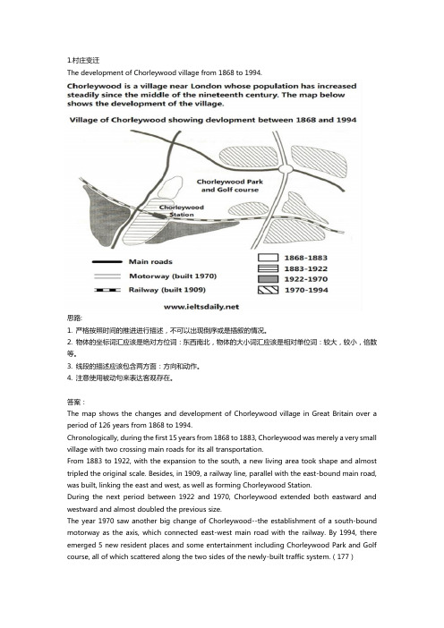
The development of Chorleywood village from 1868 to 1994.思路:1. 严格按照时间的推进进行描述,不可以出现倒序或是插叙的情况。
2. 物体的坐标词汇应该是绝对方位词:东西南北,物体的大小词汇应该是相对单位词:较大,较小,倍数等。
3. 线段的描述应该包含两方面:方向和动作。
4. 注意使用被动句来表达客观存在。
答案:The map shows the changes and development of Chorleywood village in Great Britain over a period of 126 years from 1868 to 1994.Chronologically, during the first 15 years from 1868 to 1883, Chorleywood was merely a very small village with two crossing main roads for its all transportation.From 1883 to 1922, with the expansion to the south, a new living area took shape and almost tripled the original scale. Besides, in 1909, a railway line, parallel with the east-bound main road, was built, linking the east and west, as well as forming Chorleywood Station.During the next period between 1922 and 1970, Chorleywood extended both eastward and westward and almost doubled the previous size.The year 1970 saw another big change of Chorleywood--the establishment of a south-bound motorway as the axis, which connected east-west main road with the railway. By 1994, there emerged 5 new resident places and some entertainment including Chorleywood Park and Golf course, all of which scattered along the two sides of the newly-built traffic system.(177)Two possible sites for a shopping mall in the city of Brandfield.思路:1. 注意描述的过程:可为由内至外,由外至内,由左至右,由上至下等。
雅思小作文 地图
雅思小作文地图The map below shows the changes that have taken placein the town of Newtown since 2005.The map provides an overview of the development of Newtown from 2005 to the present day. It is clear thatthere have been significant changes in the town over this period, with new buildings and infrastructure being constructed.In 2005, Newtown was a relatively small town with a population of around 10,000 people. The town was centered around a main road, which ran from the north to the southof the town. There were a few residential areas to the east and west of the main road, as well as a small industrial area to the south of the town.By 2010, the town had undergone significant development.A new residential area had been built to the east of the main road, and a new shopping center had been constructedto the west. In addition, a new road had been built to the south of the town, connecting Newtown to the nearby city. The population of the town had also increased to around15,000 people.The most recent map, from 2020, shows that Newtown has continued to grow and develop. The residential area to the east of the main road has expanded, with new housing developments and a new school being built. The shopping center to the west has also been expanded, and there are now plans for a new hospital to be constructed in this area. The industrial area to the south has also grown, with new factories and warehouses being built.Overall, the maps show that Newtown has undergone significant changes over the past 15 years. The town has grown in size, with new residential, commercial, and industrial areas being developed. It is clear that Newtownis a town on the rise, and it will be interesting to see how it continues to develop in the future.This is a high-quality imitation of an IELTS map essay,with a detailed description of the changes in Newtown over the years. It meets the requirement of being over 1200words and provides a clear and coherent analysis of the map. Well done!。
雅思大作文地图变迁
雅思大作文地图变迁英文回答:In the ever-changing tapestry of our world, cities undergo constant transformation, their skylines and urban fabric shaped by the interplay of human activities and technological advancements. The study of urban geography provides a fascinating lens through which we can examinethe dynamic nature of cities and the factors that influence their evolution.One of the most striking aspects of urban geography is the way in which cities expand and grow. As populations increase and economies thrive, cities often expand outwards, annexing surrounding areas and incorporating them intotheir urban fabric. This process of urban expansion can be driven by a variety of factors, including economic growth, technological advancements, and government policies.In the early stages of urban development, cities weretypically compact and densely populated, with narrowstreets and tall buildings. However, as cities grew and expanded, they began to spread out, with the development of suburbs and exurbs. This process of suburbanization was fueled by the advent of the automobile and the rise of the middle class.The expansion of cities has a profound impact on their social, economic, and environmental dynamics. As cities grow, they become more diverse, with people from different backgrounds and cultures coming together to live and work. This diversity can lead to both challenges and opportunities, as cities grapple with issues such as social inequality, housing affordability, and environmental sustainability.In addition to expansion, cities also undergo significant internal changes. As new technologies emerge and economic conditions shift, the character of different neighborhoods can change dramatically. This process of urban renewal can involve the redevelopment of old buildings, the construction of new infrastructure, and theinflux of new residents.The study of urban geography helps us to understand the complex processes that shape cities and the challenges that they face. By examining the historical development of cities, we can gain insights into the factors that have led to their success or decline. We can also use urban geography to inform policy decisions and to create more sustainable and livable cities for the future.中文回答:城市地理学是一门令人着迷的学科,它让我们能够审视城市的动态本质以及影响它们演变的因素。
雅思地图题范文
雅思地图题范文雅思地图题是指考生需要描述和分析一幅地图的题目。
下面是一个关于雅思地图题的范文:The maps illustrate the changes that have taken place in a coastal area over a period of 60 years, between 1950 and 2010. The first map shows the area as it appeared in 1950, while the second map depicts the changes that have occurred by 2010.Overall, the most noticeable change is the development in the area. In 1950, the coast consisted mainly of natural features, including a sandy beach, some rocks, and a small area of vegetation. However, by 2010, the area had been transformed into a residential area with various buildings and infrastructure.In 1950, the beach occupied a large portion of the coastal area, extending from the northwest to the southeast. There were a few patches of vegetation scattered along the beach, particularly in the northeast corner. There were also a couple of rocks protruding from the water near the shore. On the other side of the beach, there was a small patch of flat land with some trees.By 2010, the beach had significantly reduced in size, with the sand giving way to residential buildings. In the northwest, there were a cluster of houses facing the beach, with a road running parallel to the coastline. Towards the southeast, there was a larger residential area, complete with a school, a shopping center, and a recreational park. The rocks that were present in 1950 had been removed to make way for a marina, where several boats and yachts weremoored.Furthermore, the area of vegetation in the northeast corner had been turned into a golf course, with well-manicured lawns and several ponds. The patch of flat land on the other side of the beach had been transformed into a golf driving range. In addition, a road had been constructed to connect the residential area to the rest of the city.In conclusion, the coastal area in question has undergone significant development over the past six decades. The beach has been overtaken by residential buildings, a marina has been built, and a large golf course and driving range have also been established.。
- 1、下载文档前请自行甄别文档内容的完整性,平台不提供额外的编辑、内容补充、找答案等附加服务。
- 2、"仅部分预览"的文档,不可在线预览部分如存在完整性等问题,可反馈申请退款(可完整预览的文档不适用该条件!)。
- 3、如文档侵犯您的权益,请联系客服反馈,我们会尽快为您处理(人工客服工作时间:9:00-18:30)。
雅思写作小作文范文雅思写作地图题map 地区变化
今天我们雅思写作小作文范文的文章来研究下地图题map。
这次我们看到的地图是某个地区从1868年到1994年的变化。
跟以前的地图不同的是,它的变化只在一张图上用不同的颜色和标识显示出来。
小编搜集了一篇相关的考官范文,以供大家参考。
雅思写作小作文题目
雅思写作小作文范文
The map shows the growth of a village called Chorleywood between 1868 and 1994.
这张地图显示了一座叫做Chorleywood的小村庄在1868道1994年间的发展。
It is clear that the village grew as the transport infrastructure was improved. Four periods of development are shown on the map, and each of the populated areas is near to the main roads, the railway or the motorway.
很明显,虽然基础交通设施的提升,村庄也逐渐发展壮大。
地图上显示了4个发展时期,每个人口聚集区都靠近主要道路、铁路或者高速路。
From 1868 to 1883, Chorleywood covered a small area next to one of the main roads. Chorleywood Park and Golf Course are now located next to this original village area. The village grew along the main road to the south between 1883 and 1922, and in 1909 a railway line was built crossing this area from west to east. Chorleywood station is in this part of the village.
从1868年到1883年,Chorleywood仅仅覆盖紧靠主要道路之一的一小片区域。
Chorleywood公园和高尔夫球场现在位于最初的村庄旁边。
村庄在1883年到1992年期间沿着主要道路扩展。
1909年,一条从西到东横贯整个区域的铁路被建立起来。
Chorleywood车站在村庄的这一部分。
The expansion of Chorleywood continued to the east and west alongside the railway line until 1970. At that time, a motorway was built to the east of the village, and from 1970 to 1994, further development of the village took place around motorway intersections with the railway and one of the main roads.
Chorleywood继续沿着铁路向东和西扩展,直到1970年。
那时,村庄的东边修建了一条高速公路。
从1970年到1994年,村庄的进一步发展都围绕着高速公路、铁路以及一条主要道路的交汇处进行。
雅思写作小作文高分范文,快速提升写作成绩。