雅思地图题范文
雅思地图题范文
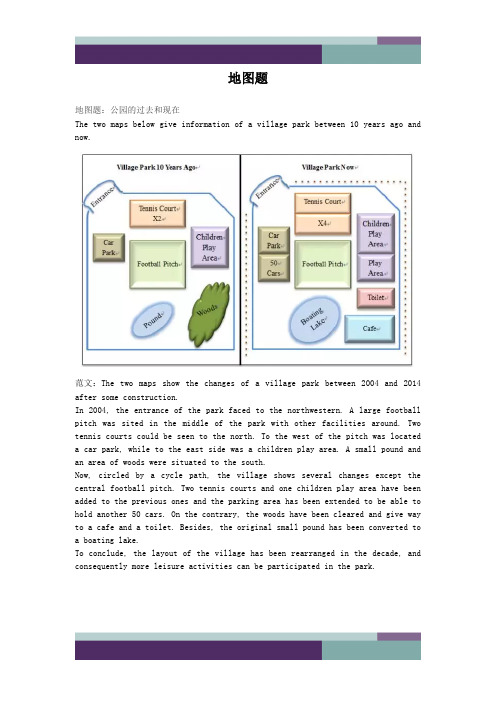
地图题地图题:公园的过去和现在The two maps below give information of a village park between 10 years ago andnow.范文:The two maps show the changes of a village park between 2004 and 2014 after some construction.In 2004, the entrance of the park faced to the northwestern. A large football pitch was sited in the middle of the park with other facilities around. Two tennis courts could be seen to the north. To the west of the pitch was located a car park, while to the east side was a children play area. A small pound and an area of woods were situated to the south.Now, circled by a cycle path, the village shows several changes except the central football pitch. Two tennis courts and one children play area have been added to the previous ones and the parking area has been extended to be able to hold another 50 cars. On the contrary, the woods have been cleared and give way to a cafe and a toilet. Besides, the original small pound has been converted to a boating lake.To conclude, the layout of the village has been rearranged in the decade, and consequently more leisure activities can be participated in the park.he i rb ei n ga re go od fo rs o 地图题:城市布局变迁The two maps show the changes of a city from 1960 to now.范文:The two maps show the development of a city from 1960 to the present.In 1960, the city was mainly based on the harbour and freight ships were moored in the northeast dock. To the east of the harbour was a business area, which was connected with the harbor and a stadium on the southern side of the river by trams. Moreover, two residential blocks were constructed at both the northern and southern ends of the city.Several major changes to the city have been observed since then. In 2014, the residential area in the north has given way to an extended business area of the one in the east. The previous dock has been occupied by some newly built restaurants and bars. The original intersecting tram frame has been simplified to a single line. Some sports facilities have been constructed between the southern residential area and the stadium, which is now also linked with the old business area by a footbridge over the river.To summarise, the landscape of the city has been rearranged, with more business replacing industry around the bay.d fo r地图题:学院布局变化The map below gives information about a college at present and its future view in 2015 after reconstruction.范文:The two figures demonstrate the estimated changes of a college between 2014 and 2015.At present, a garden lies in the northern part of the college and five car parks are located in the west. Both of them are linked to the school building by a footpath, while its entrance is in front of the garden. Inside thebuilding, a lunch area and two classrooms lie in the western side, while one more classroom, a reception and a library are in the eastern part. For the southern edge, there is a toilet in the middle, and a bus stop on the southwestern corner, accessed by a road.In 2015, several changes are expected to be witnessed. The garden and the footpath will be removed, since the teaching building will be extended. A new shop will be established in the building’s northwestern corner, and thelibrary will be moved to the southwestern end. Between them, there will be the original lunch area and one classroom, while other four classrooms will be seen in the opposite side. The entrance will be rebuilt in the middle southern edge,e an dAl t h i ng si nt he i rb ei n ga re go od adjacent to the bus stop, and the corridor behind it will be replaced by a reception.To summarize, more rooms and car parks will be constructed in the college during the period.地图题:消防设备布置The diagram shows the fire plan for the second floor of a student dorm building in a university. Summarise the information by selecting and reporting the main features and make comparison where relevant.范文:The map illustrates the escape routes in case of fire on the second floor of a university dormitory. There are one lift, two stairways and seven bedrooms on this rectangle shape floor, all with access to the corridor in the center. Once the building is on fire, the stairs on the south-west corner is convenient for the students living in the west part of the floor, specifically, Bedroom 1, 2 and 3 to escape through the corridor because Bedroom 1 and 2 are located in the northwest corner and Bedroom 3 is right opposite the stairway. When they rush out of the building, they can meet the others at the Meeting Point 1 outside the stairway.Another stairway which is sited at the north side of floor, with the lift at the west and Bedroom 7 the east, offers another escaping way in case of fire. Bedroom 4, and 6 are on the south side of the corridor but face to this stairway, and Bedroom 5 is at the east side of the floor, next to Bedroom 6,s o therefore it is also easy for the dwellers in these three rooms to rush out. Once they get out of the building, they would meet at the Meeting Point 2 near the stair room.When you are old and grey and full of sleep,And nodding by the fire, take down this book,And slowly read, and dream of the soft look Your eyes had once, and of their shadows deep;How many loved your moments of glad grace,And loved your beauty with love false or true,But one man loved the pilgrim soul in you,And loved the sorrows of your changing face;And bending down beside the glowing bars,Murmur, a little sadly, how love fledAnd paced upon the mountains overhead And hid his face amid a crowd of stars.The furthest distance in the worldIs not between life and deathBut when I stand in front of you Yet you don't know thatI love you.The furthest distance in the worldIs not when I stand in front of youYet you can't see my loveBut when undoubtedly knowing the love from both Yet cannot be together.The furthest distance in the worldIs not being apart while being in loveBut when I plainly cannot resist the yearningYet pretending you have never been in my heart. The furthest distance in the worldIs not struggling against the tidesBut using one's indifferent heartTo dig an uncrossable riverFor the one who loves you.。
剑桥雅思写作13test1真题解析及范文
剑桥雅思写作13test1真题解析及范文剑桥雅思写作13test1task1真题解析【题目+解题思路+范文】题目:TASK 1You should spend abo20 minutes on this task.The two maps below show road access to a city hospital in 2022 and in 2022.Summarise the information by selecting and reporting the main features, and make comparisons where relevant.Write at least 150 words.解题思路:1. 图表类型:地图题2. 主体段时态:一般过去时3. 题目要求:两幅地图分别展示了2022年和2022年去城市医院的通行道路。
选择一些主要的特点来描述并作出一些相关的比照。
4. 描述重点:1)2022年地图中的city hospital的东南风是staff and public car park,而在2022年这个地方变为了staff car park。
2)2022年Hospital Rd 两边的六个bus stops 没有了,在道路西边建造了较大的bus station,并有道路通往北边和南边两个环岛,分别与围绕医院的ring road 和city road相连。
范文:SAMPLE ANSWERThis is an answer written by a candidate who achieved a Band 5.5 score. Here is the e某aminer’s comment:The candidate has identified all the key features (hospital, ringroad, new public car park, staff car park and bus station in 2022) but the descriptions are not always accurate e.g. [two features that still remained. This two features are City Hospital and staff carpark] whereas the staff car park was formerly a car park for both staff and public, while the mention of the bus station is not developed. Organisation is clear, however, with some good use of cohesive devices [According to | Apart from | The further additional features], although there is an error in the use of reference pronouns [This/These two features]. The range of vocabulary is sufficient for the task [two different years | features | remained | additional], though [features] is over-used. A spelling error is noted in the second line [sourrounded] but this does not cause any difficulty for the reader; similarly, the use of [around-turn] can be easily understood as ‘roundabout’. There is a mi某 of simple and comple某 sentences, mainly used accurately.Two maps illustrate, the way to get to a city hospital of two different years (2022 and 2022).According to both maps, the main features which is city hospital is sourrounded by Ring Road. In these two maps, there have been two features that still remained. This two features are City Hospital and staff car park. Apart from these two features there are some features that shows on 2022 map but haven’t shown on 2022 map. The additional features that appear on the map of 2022 are public car parte which located on the east-side of the city hospital. The further additional features are two around-turn on the hospital Rd. which can lead to the bus station.Overall, there are two major features that never change on both 2022 and 2022 map. These features are city hospital and staff carpark. However, there are some additional features that appear on the map of 2022 but not on 2022. These features are public car park, bus station and two around-turns.剑桥雅思写作13test1task2真题解析【题目+解题思路+范文】题目:TASK 2You should spend about 40 minutes on this task.Write about the following topic:Living in a country where you have to speak a foreign language can cause serious social problems, as well as practical problems. To what e某tent do you agree or disagree with this statement? Give reasons for your answer and include any relevant e某amples from your own knowledge or e某perience.Write at least 250 words.解题思路:1. 话题和题型分类社会文化类单边讨论题型2. 题目分析居住在一个你不得不说外语的国家可能会导致严重的社交问题以及实际问题。
雅思写作小作文地图题满分范文
雅思写作小作文地图题满分范文地图题写作是一般的英语考试很少接触的,但是却是雅思考试可能会遇到的,因此考生一定要注意这方面的雅思作文写作。
下面是两篇小编整理的雅思写作小作文地图题满分范文,希望对大家有用。
雅思写作小作文地图题满分范文一话题:The diagrams below show the site of a school in 2004 and the plan for changes to the school site in 2024.(Source: Official IELTS Practice Materials 2)满分范文The two pictures compare the layout of a school as it was in the year 2004 with a proposed site design for the year 2024.It is clear that the main change for 2024 involves the addition of a new school building. The school will then be able to accommodate a considerably larger number of students.In 2004, there were 600 pupils attending the school, and the two school buildings were separated by a path running from the main entrance to the sports field. By 2024, it is expected that there will be 1000 pupils, and a third building will have been constructed. Furthermore, the plan is to join the two original buildings together, creating a shorter path that links the buildings only.As the third building and a second car park will be built on the site of the original sports field, a new, smaller sports field will need to be laid.A new road will also be built from the main entrance to the second car park. Finally, no changes will be made to the main entrance and original car park.雅思写作小作文地图题满分范文二话题:The map shows the village of Chorleywood showing development between 1868 and 1994满分范文The map shows the growth of a village called Chorleywood between 1868 and 1994.It is clear that the village grew as the transport infrastructure was improved. Four periods of development are shown on the map, and eachof the populated areas is near to the main roads, the railway or the motorway.From 1868 to 1883, Chorleywood covered a small area next to one of the main roads. Chorleywood Park and Golf Course is now located next to this original village area. The village grew along the main road to the south between 1883 and 1922, and in 1909 a railway line was built crossing this area from west to east. Chorleywood station is in this part of the village.The expansion of Chorleywood continued to the east and west alongside the railway line until 1970. At that time, a motorway was built to the east of the village, and from 1970 to 1994, further development of the village took place around motorway intersections with the railway and one of the main roads.。
雅思小作文地图题及词汇讲解
雅思小作文地图题及词汇讲解The map depicting the development of the village clearly illustrates the progress of this area。
It is divided into four main sectors with two main roads intersecting。
as well as one XXX roads.Part 1: TimeBoth flow charts and map XXX charts。
the n of the process is often expressed。
while in map ns。
time is used to show geographical changes。
Accurate time guidance not only increases the natural and coherent nature of the article。
but also reflects the n of the writing.Common time ns:In a few hoursDuring the d of。
After 10 daysFrom。
to。
XXX。
Over the。
year d5 years beforeOver the XXX。
yearsXXX sentence: The process lasts for up to 7 days and the products are finally distributed to customers.A decade earlier。
from that moment on。
after a while。
since。
since then。
finally.Part 2: SpaceSpatial n is more common in map ns。
雅思写作小作文范文 雅思写作地图题map 城镇改造.doc

雅思写作小作文范文雅思写作地图题map 城镇改造今天我们雅思写作小作文范文的文章来研究下地图题map。
该地图所展示的信息为一个名为lslip的小镇中心所计划进行的改变。
图中还很贴心的给出了方向标示。
我们可以看到相比于现在的样子,新的城镇中心将有环城公路,步行街,停车场等设施。
而原有的各种设施的大小也有所改变。
小编搜集了一篇相关的考官范文,以供大家参考。
雅思写作小作文题目The maps below show the center of a small town called Islip as it is now and plans for its development.Summarise the information by selecting and reporting the main features, and make comparisons where relevant.雅思写作小作文范文The diagrams illustrate some proposed changes to the central area of the town of Islip.该图表说明了一些都对Islip小镇中心区域所提出的一些改变。
It is clear that the principal change to the town will be the construction of a ring road around the center. Various other developments with regard to shops and housing will accompany the building of this road.很明显,该城镇最大的改变是围绕城镇中心修建了一条环路。
针对商店和住宅区域的其他各种改变会伴随着道路的修建工作进行。
Looking at the map of Islip as it is now, we can see that the main road runs through its center from east to west. The second map shows the planned pedestrianization of this road. Traffic will be diverted on to a dual carriageway that will form a ring around the town center.首先来看一下Islip镇现在的地图,我们可以看到其主干道从东向西穿过城镇中心。
雅思图表题范例

雅思图表题范例The document was prepared on January 2, 2021雅思TASK11、曲线图剑7 Test2 W1The graph below show the consumption of fish and some different kinds of meat in a European country between 1979and 2004.Summaries the information by selecting and reporting the main features, and make comparisons where relevant.The graph illustrates changes in the amounts of beef, lamb, chicken and fish consumed in a particular European country between 1979 and 2004.In 1979 beef was by far the most popular of these foods, with about 225 grams consumed per person per week. Lamb and chicken were eaten in similar quantities around 150 grams, while much less fish was consumed just over 50 grams.However, during this 25-year period the consumption of beef and lamb fell dramatically to approximately 100 grams and 55 grams respectively. The consumption of fish also declined, but much less significantly to just below 50 grams, so although it remained the least popular food, consumption levels were the most stable.The consumption of chicken, on the other hand, showed an upward trend, overtaking that of lamb in 1980 and that of beef in 1989. By 2004 it had soared to almost 250 grams per person per week.Overall, the graph shows how the consumption of chicken increased dramatically while the popularity of these other foods decreased over the period.2、柱状图C3T3W1You should spend about 20 minutes on thistask.Thecharts below show the levels of participation in education and science indeveloping and industrialized countries in 1980 and 1990.Write a report a university lecturer describing the information shownbelow.You should write at least 150 words.The data shows the differences between developing and industrialized countries’ participation in education and science.In terms of the number of years of schooling received, we see that the length of time people spend at school in industrialized countries was much greater at years in 1980, compared to years in developing countries. The gap was increased further in 1900 when the figures rose to years and years respectively.We can see a similar pattern in the second graph, which shows that the number of people working as scientists and technicians in industrialized countries increased from 55 to 85 per 1,000 people between 1980 and 1990, while the number in developing countries went from 12 to 20.Finally, the figures for spending on research and development show that industrialized countries more than doubled their spending, from $200bn to$420bn, while developing countries decreased theirs , from$75bn down to $25bn.Overall we can see that not only are there very large differences between the two economies but that there gaps are widening.3、饼状图C7T4W1The charts compare the sources of electricity in Australia and France in the years 1980 and 2000. Between these years, electricity production almost doubled, rising from 100 units to 170 in Australia, and from 90 to 180 units in France.In 1980 Australia used coal as the main electricity source 50 units and the remainder was produced from natural gas, hydro power each producing 20 units and oil which produced only 10 units. By 2000, coal had become the fuel for more than 75% of electricity produced and only hydro continued to be another significant source supplying approximately 20%.In contrast, France used coal as a source for only 25 units of electricity in 1980, which was matched by natural gas. The remaining 40 units were produced largely from oil and nuclear power, with hydro contributing only 5 units. But by 2000, nuclear power, which was not used at all in Australia, had developed into the main source, producing almost 75% of electricity, at 126 units, while coal and oil together produced only 50 units. Other sources were no longer significant.Overall, it is clear that by 2000 these two countries relied on different principal fuel sources: Australia relied on coal and France on nuclear power.4、表格类C5T4W1The take below gives information about the underground railway systems in six cities. Summarise the information by selecting and reporting the main features, and make comparisons where relevant. You should write at least 150 words.The table shows the detailed information regarding the underground railway systems in six cities, namely, London, Paris, Tokyo ,Washington DC, Kyoto and Los Angeles.London has the oldest underground railway system among the six cities which was opened in 1863. AndParis is the second oldest, and it was opened in 1900. This was then followed by other four cities, namely,Tokyo,WashingtonDC andKyoto with the opening date of 1927, 1976, and 1981 respectively. As forLos Angeles, it is the last one in this table to have its own underground railway system opened in 2001.In terms of the size of the railway system, Londonenjoys the largest underground railway systems, with 394 kilometres of route in total, which is nearly twice as large as that in Paris199 kilometres. Kyoto, in contrast, has the smallest system, for it only has 11 kilometres of route, which is nearly 1/36 of the route of London. The other three citiesTokyo, Washington DC, and Los Angeles have 155, 126 and 28 kilometres respectivelyInterestingly, Tokyo, which only has 155 kilometres of route, enjoys the greatest number of passengers per year, at 1927 million passengers. The system inParis has the second greatest number of passengers, at 1191 millions passengers per year. The smallest underground railway system,Kyoto, serves the smallest number only 45 people.In conclusion, the underground railway systems in different cities vary a lot in the opening date, the size as well as the number of passengers served per year.5、地图题真题The following two maps show the development of a coastal city from 1950 to 2007. Summarize the information by selecting and reporting the main features, and make comparisons where relevant.The two maps illustrate the changes of a coastal city between 1950 and 2007. We can see clearly that the city became more and more modern.1n 1950, the city was like a small village, with vast grassland areas all over the city. There was a sea in the north of this city, with a park to the west. In front of the park, there was a big building area where things were under construction. By that time, three large areas were all grasslands, with a cross road dividing them.However, when it comes to 2007, things experienced significant changes. A new apartment had been built where the park was, and the original building areas were converted into industry buildings such as parks, parking lots and swimming pools. The most obvious changes were that the former grasslands disappeared, becoming cinemas in the southwest, shops in the southeast, and houses in the northeast. On the north side, although the sea was still there, a wharf was built in it so people could travel more easily by sea.Finally, although there was still a cross road in the city, the horizontal road was moved to the south. By doing so, industry buildings and houses could be left more places to develop. Anyway, the city had experienced tremendous changes throughout the 57-year period.6、流程图C6T3W1The first diagram shows that there are four main stages in the life of the silk worm.First of all, eggs are produced by the moth and it takes ten days for each egg to become a silkworm larva that feeds on mulberry leaves. This stage lasts for up to six weeks until the larva produces a cocoon of silk thread around itself. After a period of about three weeks, the adult moths eventually emerge from these cocoons and the life cycle begins again.The cocoons are the raw material used for the production of silk cloth. Once selected, they are boiled in water and the threads can be separated in the unwinding stage. Each thread is between 300 and 900 metres long, which means they can be twisted together, dyed and then used to produce cloth in the weaving stage.Overall, the diagrams show that the cocoon stage of the silkworm can be used to produce silk cloth through a very simple process.。
雅思流程图和地图题范文
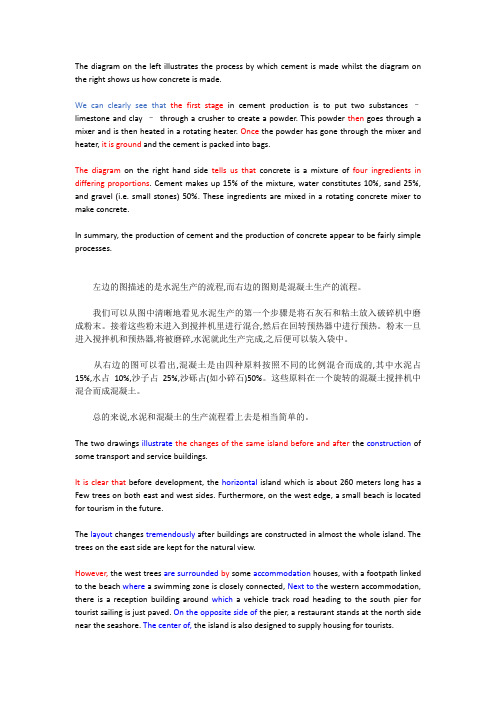
The diagram on the left illustrates the process by which cement is made whilst the diagram on the right shows us how concrete is made.We can clearly see that the first stage in cement production is to put two substances –limestone and clay –through a crusher to create a powder. This powder then goes through a mixer and is then heated in a rotating heater. Once the powder has gone through the mixer and heater, it is ground and the cement is packed into bags.The diagram on the right hand side tells us that concrete is a mixture of four ingredients in differing proportions. Cement makes up 15% of the mixture, water constitutes 10%, sand 25%, and gravel (i.e. small stones) 50%. These ingredients are mixed in a rotating concrete mixer to make concrete.In summary, the production of cement and the production of concrete appear to be fairly simple processes.左边的图描述的是水泥生产的流程,而右边的图则是混凝土生产的流程。
雅思地图题范文
雅思地图题范文雅思地图题是指考生需要描述和分析一幅地图的题目。
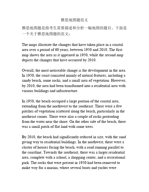
下面是一个关于雅思地图题的范文:The maps illustrate the changes that have taken place in a coastal area over a period of 60 years, between 1950 and 2010. The first map shows the area as it appeared in 1950, while the second map depicts the changes that have occurred by 2010.Overall, the most noticeable change is the development in the area. In 1950, the coast consisted mainly of natural features, including a sandy beach, some rocks, and a small area of vegetation. However, by 2010, the area had been transformed into a residential area with various buildings and infrastructure.In 1950, the beach occupied a large portion of the coastal area, extending from the northwest to the southeast. There were a few patches of vegetation scattered along the beach, particularly in the northeast corner. There were also a couple of rocks protruding from the water near the shore. On the other side of the beach, there was a small patch of flat land with some trees.By 2010, the beach had significantly reduced in size, with the sand giving way to residential buildings. In the northwest, there were a cluster of houses facing the beach, with a road running parallel to the coastline. Towards the southeast, there was a larger residential area, complete with a school, a shopping center, and a recreational park. The rocks that were present in 1950 had been removed to make way for a marina, where several boats and yachts weremoored.Furthermore, the area of vegetation in the northeast corner had been turned into a golf course, with well-manicured lawns and several ponds. The patch of flat land on the other side of the beach had been transformed into a golf driving range. In addition, a road had been constructed to connect the residential area to the rest of the city.In conclusion, the coastal area in question has undergone significant development over the past six decades. The beach has been overtaken by residential buildings, a marina has been built, and a large golf course and driving range have also been established.。
- 1、下载文档前请自行甄别文档内容的完整性,平台不提供额外的编辑、内容补充、找答案等附加服务。
- 2、"仅部分预览"的文档,不可在线预览部分如存在完整性等问题,可反馈申请退款(可完整预览的文档不适用该条件!)。
- 3、如文档侵犯您的权益,请联系客服反馈,我们会尽快为您处理(人工客服工作时间:9:00-18:30)。
地图题地图题:公园的过去和现在The two maps below give information of a village park between 10 years ago and now.范文:The two maps show the changes of a village park between 2004 and 2014 after some construction.In 2004, the entrance of the park faced to the northwestern. A large football pitch was sited in the middle of the park with other facilities around. Two tennis courts could be seen to the north. To the west of the pitch was located a car park, while to the east side was a children play area. A small pound and an area of woods were situated to the south.Now, circled by a cycle path, the village shows several changes except the central football pitch. Two tennis courts and one children play area have been added to the previous ones and the parking area has been extended to be able to hold another 50 cars. On the contrary, the woods have been cleared and give way to a cafe and a toilet. Besides, the original small pound has been converted to a boating lake.To conclude, the layout of the village has been rearranged in the decade, and consequently more leisure activities can be participated in the park.地图题:城市布局变迁The two maps show the changes of a city from 1960 to now.范文:The two maps show the development of a city from 1960 to the present.In 1960, the city was mainly based on the harbour and freight ships were moored in the northeast dock. To the east of the harbour was a business area, which was connected with the harbor and a stadium on the southern side of the river by trams. Moreover, two residential blocks were constructed at both the northern and southern ends of the city.Several major changes to the city have been observed since then. In 2014, the residential area in the north has given way to an extended business area of the one in the east. The previous dock has been occupied by some newly built restaurants and bars. The original intersecting tram frame has been simplified to a single line. Some sports facilities have been constructed between the southern residential area and the stadium, which is now also linked with the old business area by a footbridge over the river.To summarise, the landscape of the city has been rearranged, with more business replacing industry around the bay.地图题:学院布局变化The map below gives information about a college at present and its future view in 2015 after reconstruction.范文:The two figures demonstrate the estimated changes of a college between 2014 and 2015. At present, a garden lies in the northern part of the college and five car parks are located in the west. Both of them are linked to the school building by a footpath, while its entrance is in front of the garden. Inside the building, a lunch area and two classrooms lie in the western side, while one more classroom, a reception and a library are in the eastern part. For the southern edge, there is a toilet in the middle, and a bus stop on the southwestern corner, accessed by a road.In 2015, several changes are expected to be witnessed. The garden and the footpath will be removed, since the teaching building will be extended. A new shop will be established in the building’s northwestern corner, and the library will be moved to the southwestern end. Between them, there will be the original lunch area and one classroom, while other four classrooms will be seen in the opposite side. The entrance will be rebuilt in the middle southern edge, adjacent to the bus stop, and the corridor behind it will be replaced by a reception.To summarize, more rooms and car parks will be constructed in the college during the period.地图题:消防设备布置The diagram shows the fire plan for the second floor of a student dorm building in a university. Summarise the information by selecting and reporting the main features and make comparison where relevant.范文:The map illustrates the escape routes in case of fire on the second floor of a university dormitory. There are one lift, two stairways and seven bedrooms on this rectangle shape floor, all with access to the corridor in the center.Once the building is on fire, the stairs on the south-west corner is convenient for the students living in the west part of the floor, specifically, Bedroom 1, 2 and 3 to escape through the corridor because Bedroom 1 and 2 are located in the northwest corner and Bedroom 3 is right opposite the stairway. When they rush out of the building, they can meet the others at the Meeting Point 1 outside the stairway.Another stairway which is sited at the north side of floor, with the lift at the west and Bedroom 7 the east, offers another escaping way in case of fire. Bedroom 4, and 6 are on the south side of the corridor but face to this stairway, and Bedroom 5 is at the east side of the floor, next to Bedroom 6, therefore it is also easy for the dwellers in these three rooms to rush out. Once they get out of the building, they would meet at the Meeting Point 2 near the stair room.When you are old and grey and full of sleep,And nodding by the fire, take down this book, And slowly read, and dream of the soft look Your eyes had once, and of their shadows deep; How many loved your moments of glad grace, And loved your beauty with love false or true, But one man loved the pilgrim soul in you,And loved the sorrows of your changing face; And bending down beside the glowing bars, Murmur, a little sadly, how love fledAnd paced upon the mountains overheadAnd hid his face amid a crowd of stars.The furthest distance in the worldIs not between life and deathBut when I stand in front of youYet you don't know thatI love you.The furthest distance in the worldIs not when I stand in front of youYet you can't see my loveBut when undoubtedly knowing the love from both Yet cannot be together.The furthest distance in the worldIs not being apart while being in loveBut when I plainly cannot resist the yearningYet pretending you have never been in my heart. The furthest distance in the worldIs not struggling against the tidesBut using one's indifferent heartTo dig an uncrossable riverFor the one who loves you.。