杭州萧山机场ZSHC,JEPPSEN航图
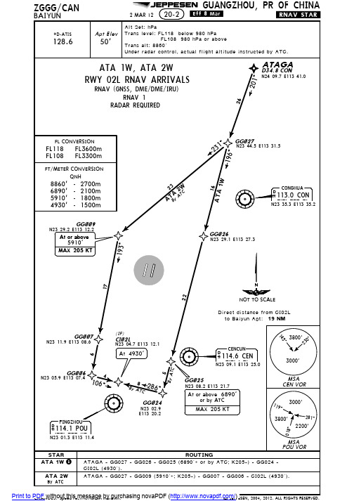
ZGGG广州白云国际机场航图
3800'
281^
2200'
MSA POU VOR
STAR
ATA 1W 1
ROUTING ATAGA - GG027 - GG026 - GG025 (6890'+ or by ATC; K205-) - GG024 CI02L (4930').
ATA 2W ATAGA - GG027 - GG009 (5910'+; K205-) - GG007 - GG006 - CI02L (4930'). By ATC
ATA 1W, ATA 2W RWY 02L RNAV ARRIVALS
RNAV (GNSS, DME/DME/IRU) RNAV 1
RADAR REQUIRED
26
201^
ATAGA
D34.8 CON
N24 09.7 E113 41.0
FL CONVERSION
FL118 FL3600m FL108 FL3300m
FT/METER CONVERSION QNH
8860' - 2700m 6890' - 2100m 5910' - 1800m 4930' - 1500m
GG~~9
N23 29.2 E113 12.2
At or above
5910' MAX 205 KT
231^
GG~27
N23 44.5 E113 31.5
1 By ATC while simultaneous parallel approaches implemented.
145^
3800'
^032
3000'
Jeppesen航图讲解解析

J e p p e s e n航图讲解解析-CAL-FENGHAI.-(YICAI)-Company One11、使用杰普逊航图必须记住以下使用惯例:速度的单位是节; 时间是世界协调时(UTC); 垂直距离的单位是英尺; 水平距离的单位是海里; 航向是磁航向,除非后缀T 表示为真航向; 航图投影是兰勃特圆锥投影。
2、航图航行通告航图变更通知每周或隔周发布一次。
该部分包括国家空域系统中相关的临时航行通告(时限长于每日航行通告)和设施关闭、频率改变和临时不可用的助航设备的通告。
航图变更通知按国家、城市和机场的字母顺序公布。
4、航图索引号终端区航图总体上可以分为区域图、离场图、进场图、机场图等“0”系列图和进近图两类。
1)、“0”系列航图索引号“0”系列航图的索引号格式为“0 - #×”。
“”号为从1开始的数字,代表同一个城市的机场编号, “#”号代表除了进近图以外的终端区航图类型,为数字;当机场只有一张某一类型的终端区航图时,“×”号为空,当机场有多张某一类型的终端区航图时,从第二张航图开始,“×”号为从A 开始顺序编号的大写字母。
“0”系列航图索引号代表的航图类型2)、进近图索引号进近图索引号一般用3位数字表示,第一位数字为同一城市的不同机场编号,第二位数字代表进近程序类型,第三位数字代表同一类进近程序的不同顺序号,按照跑道编号从低到高依次编排,若同类进近图还有次级的划分类型,其编号就在第三位数字后面从A 开始依次编号。
第一位:同一城市机场编号进近图索引号5、航路图覆盖代码、全称杰普逊航路图覆盖范围代码、全称一览表代码全称E(HI)欧洲EUROPE高空航路图E(LO)欧洲EUROPE低空航路图E(H/L)欧洲EUROPE高/低空航路图US(HI)美国UNITED STATES高空航路图US(LO)美国UNITED STATES低高空航路图US(LO)NE美国东北沿海NORTHEAST COASTAL低空航路图US(LO)SE美国东南沿海SOUTHEAST COASTAL低空航路图CA(HI)加拿大-阿拉斯加CANADA-ALASKA高空航路图CA(LO)加拿大-阿拉斯加CANADA-ALASKA低空航路图CA(H/L)加拿大-阿拉斯加CANADA-ALASKA高/低空航路图AK(LO)阿拉斯加ALASKA低空航路图AT(H/L)大西洋ATLANTIC OCEAN高/低空航路图P(H/L)太平洋PACIFIC OCEAN高/低空航路图LA(H/L)拉丁美洲LATIN AMERICA高/低空航路图AU(LO)澳大利亚AUSTRALIA低空航路图AU(HI)澳大利亚AUSTRALIA高空航路图AS(H/L)澳大利亚AUSTRALIA高/低空航路图A(HI)非洲AFRICA高空航路图A(H/L)非洲AFRICA高/低空航路图FE(H/L)远东FAR EAST高/低空航路图SA(HI)南美SOUTH AMERICA高空航路图SA(LO)南美SOUTH AMERICA低空航路图EA(H/L)欧亚大陆EURASIA高/低空航路图ME(H/L)中东MIDDLE EAST高/低空航路图ME(HI)中东MIDDLE EAST高空航路图CH(H/L)中国CHINA高/低空航路图6、巡航高度/高度层说明巡航高度/高度层以带有磁方位角扇区或者真方位角扇区的巡航高度刻度盘形式来表达。
ZSSS 虹桥机场JEPPESEN航图

1.1.ATISATIS132.251.2.TAXI PROCEDURES1.2.1.GENERALTWY K1 and Taxilanes L01, L03 and L04 MAX wingspan less than 213’/65m.Taxilane L07 MAX wingspan less than 198’/60.4m (213’/65m when towed).Turning from TWY A to TWY H4 segment between RWY and TWY A and vice versa MAX wingspan 125’/38m.Taxilane L02 MAX wingspan 118’/36m.Taxilanes L05 and L06 MAX wingspan less than 118’/36m.Taxilane L11 MAX wingspan 171’/52m.It is strictly forbidden to taxi backward on own power without permission.1.2.2.RWY CROSSINGTWYs H1, H4 and H7 used for crossing RWY 18L/36R.TWYs H1 thru H7 used for crossing RWY 18R/36L.Cross the RWY immediately upon receiving the crossing clearance.Repeat all ATC instructions concerning "hold short of RWY or cross the RWY".Any questions shall be clarified before crossing RWY.Finally, report to controller "runway vacated".1.3.PARKING INFORMATIONVisual docking guidance system available for stands 221 thru 275.On stands 22 and 23 push-in required.On stands 24 thru 26 push-in and push-back required.On stand 76, 98A, 98B, 98C and 99 push-back required.On stands 21 thru 23, 96, 97 and 917 IDLE engine test can be carried out.Stands 401 and 402 available for run-up.1.4.OTHER INFORMATIONBirds.RWYs 18L and 18R right-hand circuit.Turns of more than 90^ on RWY or TWY are forbidden.2. ARRIVAL2.1.RWY OPERATIONSRWY 18L/36R mainly used for arrival.Landing ACFT shall vacate RWY rapidly using the appropriate rapid exit TWY and report to Tower immediately after vacating RWY.If ACFT can not use the rapid exit TWY, pilot shall inform controller in advance.TWYs H3 thru H5 can not be used for vacating RWY.3.1.DE-ICINGWhen RWY 18L/36R in use, enter de-icing stands 98C or 99 (nose facing South) viaTWYs A and TWY K6 and enter de-icing stands 917 or 918 (nose facing North) viaTWY H7.When RWY 18R in use, exit assigned de-icing stands via TWY H1.When RWY 36L in use, exit assigned de-icing stands via TWY H7.During de-icing, use of Taxilane L01 behind de-icing stands 98C and 99 respectively 917 and 918 is forbidden to use.3.2.START-UP AND PUSH-BACK PROCEDURESDeparting ACFT shall contact Delivery for delivery clearance within 10 min prior to start-up.Before push-back and start-up, departing ACFT shall contact HONGQIAO Ground for push-back and start-up clearance and conduct within 5 min, otherwise, apply theclearance once more.HONGQIAO Ground will notify the ACFT at appropriate time to contact Tower forfurther ATC instructions.In order to avoid frequency congestion, pilot shall leave Tower frequency withoutRTF instruction from controller as soon as airborne and contact the frequencyassigned in the delivery clearance immediately.ACFT using stand 2 shall not start-up until pushed to the taxilane West of stand 3 or North of stand 6.Acft using stand 76 will be pushed back with nose Westwards if stands 65, 66 and 75 not occupied, otherwise with nose Eastwards to Aprons B or C before start-up.ACFT on stands 406 and 411 with wingspan more than 171’/52m shall be pushed out directly to TWY D.3.3.NOISE ABATEMENT PROCEDURES3.3.1.RUN-UP TESTSEngine run-ups are subject to AOC permission and Tower clearance, and may only be carried out at a designated location.Testing period and engine noise shall be controlled.Stands for run-up tests installed East of stands 401 thru 406, available for ACFTwith MAX wingspan 65m with nose to south. Fast engine run-ups can be carried out there or by ATC. Engine idle test can be carried out at stands 96, 97, 917 and21thru23.3.3.2.TAKE-OFFUpon condition of complying with the requirements of obstacle clearance and climbgradient required by flight procedure, the following noise abatement climbprocedures shall be implemented:The derated take-off is strongly recommended, if take-off performance of ACFTpermits.At 450m (1500')-reduce thrust to not less than climb power;-climb at V2 + 20 km/h (10 KT) with flaps/slats in take-off configuration;At 910m (3000')-accelerate to en-route climb speed and retract flaps/slats on schedule while maintaining a positive rate ofclimb.If the procedures can not be implemented due to any reason other than ATC,controller shall be informed by the pilot.3.4.RWY OPERATIONSRWY 18R/36L mainly used for departure.400m 1600mRVRVIS 500mRVROther2 TURB Eng or3 &4 Eng NIL (DAY only)RLTAKE-OFF RWY 18L/R, 36L/R。
首都机场杰普逊航图 2010 版 ZBAA JEPPESEN 2010

Licensed to NW_airlines. Printed on 28 Oct 2010.REVISION LETTER For Disc 21-2010JEPPESEN JeppView 3.7.2.1Page 1Changed chart(s) since Disc 20-2010ADD = Added chart, REV = Revised chart, DEL = Deleted chart.ACT PROCEDURE IDENT INDEX REV DATE EFF DATEBeijing, (Beijing Capital - ZBAA)REV AIRPORT BRIEFING (ARR)10-1P215 окт 201021 окт 2010REV AIRPORT BRIEFING (DEP)10-1P315 окт 201021 окт 2010REV DOGAR & VYK 7A RNAV ARRS 10-2B 15 окт 201021 окт 2010REV DOGAR 7B & 7C, VYK 7D & 7E ...10-2C 15 окт 201021 окт 2010REV TAXI ROUTES FOR RWYS 01, 3...10-9B 15 окт 201021 окт 2010REV TAXI ROUTES FOR RWYS 18L, ...10-9C 15 окт 201021 окт 2010REV PARKING STANDS WEST 10-9D 15 окт 201021 окт 2010REV PARKING STANDS EAST 10-9E 15 окт 201021 окт 2010REV PARKING STANDS NORTH10-9F 15 окт 201021 окт 2010REV VISUAL DOCKING GUIDANCE S...10-9G 15 окт 201021 окт 2010TERMINAL CHART NOTAMs Chart NOTAMs for Airport ZBAA Type: TerminalEffectivity: TemporaryBegin Date: ImmediatelyEnd Date: Until Further Notice(10-9F) Stand N111 avbl north of stand 110.General InfoBeijing, CHNN 40° 04.4' E116° 35.7' Mag Var: 5.8°W Elevation: 115'Public, IFR, Control Tower, Customs, Landing Fee Fuel: Jet A-1Repairs: Minor Airframe, Minor EngineTime Zone Info: GMT+8:00 no DSTRunway InfoRunway 01-19 12467' x 197' concreteRunway 18L-36R 12467' x 197' asphaltRunway 18R-36L 10499' x 164' asphaltRunway 01 (359.0°M) TDZE 90'Lights: Edge, ALS, Centerline, TDZStopway Distance 197'Runway 18L (179.0°M) TDZE 115'Lights: Edge, ALS, CenterlineStopway Distance 197'Runway 18R (179.0°M) TDZE 115'Lights: Edge, ALS, Centerline, TDZRight TrafficStopway Distance 197'Runway 19 (179.0°M) TDZE 98'Lights: Edge, ALS, CenterlineStopway Distance 197'Runway 36L (359.0°M) TDZE 110'Lights: Edge, ALS, CenterlineStopway Distance 197'Runway 36R (359.0°M) TDZE 106'Lights: Edge, ALS, Centerline, TDZRight TrafficStopway Distance 197'Communications InfoATIS 128.65 Departure ServiceATIS 127.6 Arrival ServiceBeijing Tower 124.3Beijing Tower 118.6Beijing Tower 118.5Beijing Tower 118.3Beijing Tower 118.05Beijing Ground Control 121.95 Secondary Beijing Ground Control 121.9Beijing Ground Control 121.85Beijing Ground Control 121.8Beijing Ground Control 121.75Beijing Ground Control 121.7Beijing Clearance Delivery 121.65Beijing Clearance Delivery 121.6Beijing Approach Control 125.05 Secondary Beijing Approach Control 129.0 Secondary Beijing Approach Control 127.75Beijing Approach Control 126.5 Secondary Beijing Approach Control 126.1Beijing Approach Control 121.1Beijing Approach Control 120.6Beijing Approach Control 119.7Beijing Approach Control 119.0 Notebook Info1.1.ATISATIS Arrival127.6ATIS Departure128.651.2.RWY OPERATIONSGeneral rules for use of RWYs-01/19 is mainly used for arrival.-18L/36R is mainly used for departure.-18R/36L is used for departure and arrival.The three parallel RWYs will be used for departure upon departure rush hour.The three parallel RWYs will be used for arrival upon arrival rush hour.1.3.TAXI PROCEDURESFor Taxiing Routings refer to 10-9 charts.RWY 18L/36R crossing rules:TWYs A0, A1, A8, A9 are available for crossing RWY 18L/36R.Taxi following the instruction of GND Control to the holding position and hold short of RWY 18L/36R; request TWR Control for crossing clearance; verify any questionsprior to crossing; repeat all the ATC instructions for clarity, then put in practice as soon as possible; finally, report to TWR Control 'RWY vacated'.Flight crew shall monitor the TWR freq and watch the activities on the RWY 18L/36R and around.While crossing RWY 18L/36R after the take-off ACFT, flight crew shall beresponsible for the safety distance with the ACFT to avoid the effect of waketurbulence.If failure to change the assigned GND frequency, stop prior to the intersection of the two GND sectors and contact the original GND frequency.Taxiing routes of special flight will be instructed by ATC.Simultaneous taxiing on TWYs Y1 and Y2 (south part of TWY G1) is strictlyforbidden.TWYs Z12 and Z0 (South of Z13) MAX wingspan 112’/34m.TWY Z13 MAX wingspan 79’/24m.1.4.PARKING INFORMATIONPush-back required for all stands, except stands 261 thru 263, 265 thru 267,701thru717 (up to CAT C ACFT) and W104 thru W107.Visual docking guidance system available for stands at Apron 3 thru 5 for otherstands ACFT shall be guided by marshaller.Wing lights of A330-200 are forbidden to turn on while rear door connecting with air bridge, contact Terminal Airfield Management Control Center for the clearance ofturning on the wing lights and conduct after the air bridge retracted.Taxi lights are forbidden to turn on unless the ground personal have evacuated from the front of the taxi lights.1.5.OTHER INFORMATIONRWYs 01 & 18R right-hand circuit.1.5.1.SIMULTANEOUS OPERATIONS ON PARALLEL RWYsRWYs 36L, 36R & 01 may be used for independent parallel ILS approaches.RWYs 18L, 18R & 19 may be used for dependent parallel ILS approaches.All parallel RWYs may be used for independent parallel departures. Departing ACFT shall conduct first turn as soon as possible according to ATC instructions afterbecome airborne when independent parallel departures implemented.Landing ACFT shall vacate the RWY as soon as possible (within 50 seconds fromflying over RWY THR to vacating the RWY), otherwise inform TWR controller before landing.Upon receipt of approaching clearance, the pilot shall monitor the operatingsituations of other ACFT in the vicinity using airborne equipment such as ACAS and establish the visual separation as practicable, then report "visual separationestablished" when the controller notifies the relativ position to other ACFT.2. ARRIVAL2.1.CAT II OPERATIONSRWY 01 and RWY 36R are approved for CAT II operations, special aircrew and ACFT certification required.Landing and departure ACFT shall be guided by Follow-me car.When ACFT taking-off from RWY 36L or RWY 36R, RWY 36R and RWY 01 are available for arrival.2.2.TAXI PROCEDURESTWY C4 is used by ACFT turn to North from TWY P4.TWY C5 is used by ACFT turn to South from TWY P5.After vacating RWY, especially under conditions of low visibility, report the RWYdesignation and TWY designation on initial contact with GND.Operation during snow weather:Arriving ACFT with 4 engines (or more) shall keep the outside engines in idle state after vacating RWY until entering into stand.2.3.OTHER INFORMATION2.3.1.EMERGENCY AVOIDANCE FOR RWY 01ACFT beyond 5.4NM/10km from RWY THR, radar vectoring, contact BEIJINGApproach; ACFT within 5.4NM/10km from RWY THR, turn RIGHT, heading 090^,climb to 1970'/600m and maintain the altitude, contact BEIJING Approach.2.3.2.EMERGENCY AVOIDANCE FOR RWY 18LACFT beyond 5.4NM/10km from RWY THR, radar vectoring, contact BEIJINGApproach; ACFT within 5.4NM/10km from RWY THR, keep track 179^, climb to3940'/1200m and maintain the altitude, contact BEIJING Approach.2.3.3.EMERGENCY AVOIDANCE FOR RWY 18RACFT beyond 5.4NM/10km from RWY THR, radar vectoring, contact BEIJINGApproach; ACFT within 5.4NM/10km from RWY THR, turn RIGHT, heading 270^,climb to 2960'/900m and maintain the altitude, contact BEIJING Approach.2.3.4.EMERGENCY AVOIDANCE FOR RWY 19ACFT beyond 5.4NM/10km from RWY THR, radar vectoring, contact BEIJINGApproach; ACFT within 5.4NM/10km from RWY THR, turn LEFT, heading 090^,climb to 1970'/600m and maintain the altitude, contact BEIJING Approach.2.3.5.EMERGENCY AVOIDANCE FOR RWY 36LACFT beyond 5.4NM/10km from RWY THR, radar vectoring, contact BEIJINGApproach; ACFT within 5.4NM/10km from RWY THR, turn LEFT, heading 300^, climb to 6890'/2100m and maintain the altitude, contact BEIJING Approach.2.3.6.EMERGENCY AVOIDANCE FOR RWY 36RACFT beyond 5.4NM/10km from RWY THR, radar vectoring, contact BEIJINGApproach; ACFT within 5.4NM/10km from RWY THR, keep track 359^, climb to3940'/1200m (1970'/600m for RNAV ILS 36R) and maintain the altitude, contactBEIJING Approach.3. DEPARTURE3.1.DE-ICING3.1.1.RWY IN USAGEWhen RWYs 18L/R and 19 are in use, east area of RWY 36R/18L de-icing at stands all day, west area of RWY 36R/18L 0000-0700LT de-icing at stands and 0700-2400LTde-icing at de-icing positions.When RWYs 36L/R and 01 are in use, 0000-0700LT de-icing at stands, 0700-2400LTde-icing at de-icing positions.3.1.2.PUSH-BACK AND TAXIINGContact Tower before push-back and follow ATC instructions to taxi to de-icingholding position.3.1.3.TAXIING TO DE-ICING POSITIONTaxi behind Follow-me car to de-icing position.3.1.4.BEFORE DE-ICINGStop ACFT and follow marshallers instructions, shut down engines and releasebrakes after notification to be blocked by ground staff.3.1.5.AFTER DE-ICINGContact Tower for start-up.If APU failure happens on the de-icing position, notify maintenance personimmediately.3.2.START-UP, PUSH-BACK & TAXI PROCEDURESDeparting ACFT shall contact Aerodrome Delivery Control for departure clearancenot earlier than 10 minutes prior to push-out for engine start-up.Fast engine run-ups in the vicinity of boarding bridges, on apron or TWYs are strictly forbidden.While pushed-back from parking stand, verify the pushing direction and the approved RWY designation to GND control.Operation during snow weather:Departing ACFT with 4 engines (or more) shall keep the outside engines in idle state after pushing out until entering into RWY.3.3.NOISE ABATEMENT PROCEDURESUpon condition of complying with the requirements of obstacle clearance and climbgradient required by flight procedure, the following operating procedures for take-off climb shall be implemented:Take-off to 500m (1650')-take-off power;-take-off flaps/slats;-climb at V2 + 20 km/h (10 KT);At 500m (1650')-reduce thrust to not less than climb power;-climb at V2 + 20 km/h (10 KT) with flaps/slats in take-off configuration;At 950m (3120')-accelerate to en-route climb speed and retract flaps/slats on schedule while maintaining a positive rate ofclimb.3.4.RUNWAY OPERATIONSIf ACFT needs full RWY length for take-off, contact BEIJING Delivery upon receiving delivery clearance.Licensed to NW_airlines. Printed on 28 Oct 2010.Notice: After 5 Nov 2010 0901Z, this chart may no longer be valid. Disc 21-2010JEPPESENJeppView 3.7.2.1 BEIJING, PR OF CHINALicensed to NW_airlines. Printed on 28 Oct 2010.Notice: After 5 Nov 2010 0901Z, this chart may no longer be valid. Disc 21-2010JEPPESENJeppView 3.7.2.1 BEIJING, PR OF CHINA。
我国民航主要机场 ppt课件
Greiner)的设计方案,由主楼、连接楼、指廊和高架连廊
四大建筑结构组成,总面积达37万平方米,主楼共分为4层,
包括地上3层及地下1层,其中第三层为出发大厅,第二层
新华航空、大新华快运、首都航空、天津航空)
(2)2号航站楼
中国东方航空公司、中国南方航空公司、厦门航空公
司、深圳航空公司、重庆航空公司、海南航空(国际航
班),以及天合联盟的外航和非联盟的外航服务。
(3)3号航站楼
中国国际航空公司、深圳航空公司。山东航空公司、
上海航空公司、四川航空公司,以及星空联盟的外航,寰
宇一家的外航和非联盟的外航服务。
ppt课件
20
6、服务内容
(1)地面服务 (2)空港物流 (3)飞机维修 (4)进口口岸
ppt课件
21
Байду номын сангаас
7、交通换乘
(1)高速公路 (2)摆渡车 (3)轨道交通 (4)出租车 (5)机场巴士
8、机场事故
ppt课件
22
(二)广州白云国际机场
(4)2004年09月20日,整修一新的一号航站楼重新投入使 用,专门承载中国南方航空公司航班。
ppt课件
16
(5)2005年01月29日,56年来中国大陆和台湾之间首次不 中停香港的台商包机在机场降落。
(6)2009年11月30号,北京首都国际机场迎来了本年度第 6000万名旅客,使得该机场成为世界第四大机场。
2、历史沿革
(1)1933年夏季,广州白云机场建成,机场原址 位于广州市白云区西侧。最初主要用于军事目的, 后改建成民用。
(2)1992年就开始进行新机场的选址工作,经过 多年准备,最终选址距市区北部28公里的花都区新 华街道、花山镇、花东镇及白云区人和镇的交界处, 占地规模比原机场大近5倍。
国内机场简易航图册

国内机场简易航图册编著 冷 锋本图册包含国内46个机场,航图由Jeppesen FliteStar 8.51 导出,每页一个机场,包含绝大部分跑道的ILS 频率和机场通信信息,可作为VFR 进离场参照使用,仅个别机场因手头缺少资料未能补全。
所有航图只作为模拟飞行的参考,不可用于真实飞行使用。
在航图中点击机场内的星型标志可显示该机场相关的通讯频率。
版权所有飞行者俱乐部/bbs微软模拟飞行家http://59.33.37.77:8080/msfsbbs500500500500500500500500HONG KONGLANTAU ISLANDERZHOU DAOZHIWAN DAO BaoanChiu-Lung-Hsin-KuanFan LingNantouShekouYuen LongWAILINDING DAO69123691215182124273033369121503691215182124273033369121518212427303336912151821242730339121518212427CASTLE PEAK RANGE12000GNDATIS 128.2HONG KONG-IntlVHHH 19-124Hong Kong Sek Kong VHSK 50-41ATIS 127.45SHENZHEN Baoan ZGSZ 13-111UNL GND90GNDUNL 808020118GNDW 18A 461B330 2A02 L 642M 7710 P 91A 150VORBAILYCD07LCD34CI07LCI07RCL16CQ33D040CD040GD065FD065LD065RD126UD153ID155ZD157UD157VD202XD210XD224VD233M D245DD253C D259ED274KD300RFD07LFD25RFD33FI07LFI07R FI25LFI33FQ33LARCHLIMESLOTUSMALINMD07LNLG28PRAWNRAZORRENNYRIVER ROACHSOKOEBEKOLMCU09PAPAShenzhenTaipoTuanmunShiongshuiTinshuiweiXianggangziN 22?10.00'E 113?45.00'N 22?25.00'E 113?55.00'E 114?05.00'香港国际机场(VHHH)07L/111.1 07R/109.3 25L/108.9 25R/110.9跑道/仪表着陆频率:500HENGQIN DAOLANTAU ISLANDSANZAO DAOMacauXiazhaDAWANSHAN DAOWAILINDING DAO3691215182124273033369121518212427303336912151821242730332124273033242151821ATIS 126.4MACAU-IntlVMMC 20-110ZHUHAI Sanzao ZGSD 21-131UNL GND90GNDUNL 808020118GNDR 473 R 200-473 W 23W 18W 6W7B330 0R 20 2A02 BAILYCD07LCD34CI07LCI07RCL16D038HD040GD055JD147HD155JD155ZD157UD157VD202XD210XD219ND224VD228VD233M D245DD245R D245V D259ED274KD292XD344MD344NFD07LFI07LFI07RLIMESMALIN ML16NLG28PRAWNRENNYROMEOSMT30SOKOEMCU09PAPASIERAAomenN 22?00.00'E 113?25.00'N 22?15.00'E 113?35.00'E 113?45.00'澳门国际机场(VMMC)跑道/仪表着陆频率: 16/无 34/109.7HuairouNiubaotun369122731518213327ATIS 127.6BEIJING -Capital ZBAA 115-1241CD36RCF36LCF36RD196RD232CFD36RHUR34BeijingShunyiTongzhouE 116?40.00'315182133ABHETBayan Tohoi3518213ZBLA 2169-8591 15CD33CI33FD33LianzhouJunliangchengXianshuigu Xiaozhan391CF34CN34D149ID167IXianshuigu0Dongyang912FD31FQ31OM31Yuci250500100050100050500500500500BayiashanHuanghuashi LanglishiLongtoupuQingshanshiShashijieWumeishan3691215182124273033ATIS 128.8CHANGSHA Huanghua ZGHA 217-85UNL GND UNL GNDCD18CD36CF18CF36CN18CN36D002GD007ND026RD035QD151YD174LD174MD179J D194KD339HFD18FD36FI18FQ18OM18OM36ChangshaN 28?00.00'E 113?05.00'N 28?15.00'E 113?15.00'N 28?30.00'E 113?25.00'长沙黄花国际机场(ZGHA)跑道/仪表着陆频率: 18/110.3 36/109.900100010009133W 2D119GD120FD158HD165RD186DMAMSI50001821243033500500HENGQIN DAOSANZAO DAOGAOLAN DAOHEBAO DAOGujingMacauQianwuDAMANG36912151821242730333691215182124273033315182124273033ATIS 126.4MACAU -IntlVMMC 20-110ZHUHAI Sanzao ZGSD 21-131UNL GNDUNL808020118GNDR 473 R 200-473 W 23W 6W7R 200 2 A02 CD34D038HD055JD147HD155JD219ND245V D249NKILO ML16ROMEOSMT30FOXTTPAPASIERAZhuhaiN 21?50.00'E 113?15.00'N 22?05.00'E 113?25.00'N 22?20.00'E 113?35.00'珠海三灶机场(ZGSD)跑道/仪表着陆频率: 05/110.1 23/108.3500500500HONG KONG BaoanGuanlanHoujieNantouShekouSonggangXiazha3691215212427303336912151821242730333691215182124273033369121518213336912151821242730333691215182124273033CASTLE PEAK RANGE12000GNDATIS 128.2HONG KONG -IntlVHHH 19-124Hong Kong Sek Kong VHSK 50-41ATIS 127.45SHENZHEN Baoan ZGSZ 13-111UNL GND UNL GND118GND 18711890GNDUNL 808020118GNDW 23W 18W 6W 6A 461 B330 W 1850VOR CQ33D038HD040CD040GD055JD065DD065FD065LD166ND208FD224VD245DD245R D245VD251BD253CD259E D274KD292XD300MD311KD349JFD15FD33FI07LFI15FI25LFI33FQ33RITCHROACHSAKODSOSMAXK32TuanmunTinshuiweiN 22?30.00'E 113?40.00'N 22?45.00'E 113?50.00'E 114?00.00'深圳宝安国际机场(ZGSZ)跑道/仪表着陆频率: 15/111.3 33/110.791FI30FQ3039ATIS 126.6WUHANTianheZHHH 112-111WuhanZhifang915D168M691 G D122DD141C D148CD154EOM23200003000315182133D071D0?55.00'327A 581CI03CQ03D152ED194NFF03FQ03Haikou10002502510002501000250252525025025025025025010002502000250250250250250500250100250250250200500250250AotouChin-MenDatongDianqianGulangyuHaicheng JiaomeiLianheXindian3691215182124273033ATIS 127.2CHIN MEN Shang Yi RCBS 93-98ATIS 126.25XIAMEN Gaoqi ZSAM 59-111801230GND 8012 AGL 30GNDUNK GND7A 40 W1039DMECCD05CD23CF06CI05CI23CN05CQ05DD027FD027ND032QD048ND051ND055FD059ND232G D235SD246PFD05FD23FF06FQ05HEYENMA06MA308OM05TAMAUZUSANXiamenN 24?20.00'N 24?35.00'N 24?50.00'厦门高崎国际机场(ZSAM)跑道/仪表着陆频率: 05/110.3 23/109.79 1250250Langqi 691291273033912D037TD037YTantou250Maan3691215279D282SD282ZShaoxing225010005002501005001000250HongjiaiouJiuzhangqiuMingshui3691215182124273033Yaoqiang JINAN ZSJN 75-118UNK 276276GND3 A 59CF01CF19CN01CQ19D186MD186PD197ID198I D241MD343JD343QD360LD360QFD01FF19OM01ABARJinanMingshui N 36?40.00'N 36?55.00'N 37?10.00'济南遥墙国际机场(ZSJN)跑道/仪表着陆频率: 01/108.9 19/无91FD31 052502502502502502502502502502525252525025025025025025025250250250250DongshanMolingguanXiaodanyangZaicheng36912151821242730333691215182124273033ATIS 126.25NANJING Lukou ZSNJ 49-118UNL 276UNK GNDUNK GNDR 343R 343A 470 4 A 7CD06CD24CI24CN24D251MD261PD262KD266KD310FD349ID349KFD06FD24FI24OM06OM24Nanjing N 31?35.00'N 31?50.00'32?0500N 32?05.00南京禄口国际机场(ZSNJ)跑道/仪表着陆频率: 06/110.3 24/110.9250250250250250250250250250250250250250250250250CuozhenDianbuLiangyuanSanhezhenShangpaiheWushan03691215182124273033HEFEILuogang ZSOF 95-98UNL 276276GNDUNK GNDR 343 3 R34 CD14CD32CI14CI32CQ14CQ32D092H D099HD099ID099MD128KD133LD134E D139G D146LD158DD186LD190ED252KD252L D252MD262KD319CFD14FD32FQ14FQ32N 31?35.00'N 31?50.00'N 32?05.00'合肥骆岗机场(ZSOF)跑道/仪表着陆频率: 18/109.1 32/108.3CHANGXING DAOHENG SHAChuanshaFengchengHuinanMinhangNichengZhou Pu036912151821242730333691215182124273033036912151821242730333691215182124273033ATIS 127.85SHANGHAI ZSPD 10-131Pudong UNK GNDUNKGND4G 55G 455G 327A 593CF17CF35D009ED015LD050ID050KD068CD068ED069MD070LD109DD121ND139MD152LD167HD167KD167TD203FD208ED227ED232FD321FD338JD347DD352KFD17FI17OM35D081JD082LN 31?00.00'N 31?15.00'上海浦东机场(ZSPD)16/108.7 17/110.7 34/108.3 35/111.9跑道/仪表着陆频率:250250100025025025025025025000010002502505002502250500250AoshanweiCangkouLancunNancunNiuqibu36303303691215182124273033QINGDAO Liuting ZSQD 33-111UNK GNDCF17CF35D012LD025OD051FD070ED070ID176P D261DD272KD333HD353GD356GFD17FI17FQ35MM35OM35QingdaoJimoLicungN 36?05.00'N 36?20.00'N 36?35.00'青岛流亭国际机场(ZSQD)跑道/仪表着陆频率: 17/110.7 35/111.7CHANGXING DAOFengchengLiuheLuodianMinhangNanbuNanqiaoNanxiangSijingSongjiangTaicangZhou PuZhujing36912151821242730333691215182124273033ATIS 132.25SHANGHAIHongqiao ZSSS 10-111UNK GNDUNKGNDA 5935G 45A 599 G 204A 593G 330 CD18CD36CF18CF36D006OD015LD060ED070LD136ID160ED176PD188SD196FD202ED218GD232FD235LD263ED277D D282C D322H D331JD342ED355J SX39D081JD082LD235LD313OPOMOKMinhangSongjiang JiadingN 31?00.00'E 121?10.00'N 31?15.00'E 121?20.00'N 31?30.00'E 121?30.00'上海虹桥机场(ZSSS)跑道/仪表着陆频率: 18/109.1 36/110.350010005002525252505005002502505002502505005002502502502502502502505005002501000FushanMuping3691215182124273033YANTAI Laishan ZSYT 59-85UNK GNDW 4CD22CF04CI22D044L D060TD068OFD22OM04OM22YantaiFushanNinghai N 37?15.00'E 121?10.00'N 37?30.00'E 121?20.00'E 121?30.00'烟台莱山机场(ZSYT)跑道/仪表着陆频率: 04/111.7 22/110.92000927ATIS 126.4CHONGQING Jiangbei ZUCK 1365-91CD02D199LChongqing951821797 AGLW 90?25.00'200027391D156QD156T7000212733CI36D180PShule31518212733D171ED172E Kashi3151821333ZWWW 2126-118UrumqiDongshan7?35.00'273 A 588Wuija12Shuangcheng5005006912Mudanjiang1250250250500250250250500250250250250SanshilipuDASHAN DAOXIMAYI DAO3691215182124273033ATIS 126.65Zhoushuizi DALIAN ZYTL 108-108280GND UNL 280A 588W8W 5CD10CD28CF10CF28CQ10D084FD103ND217ED283ED309FFD28JinzhouDalianwanLushunkouN 38?45.00'E 121?20.00'N 39?00.00'E 121?35.00'N 39?15.00'E 121?50.00'大连周水子机场(ZYTL)跑道/仪表着陆频率: 10/109.1 28/111.16912200010005002000500200020001000200020001000100010005002000100010001000300010001000100050010002000200100010002000KOREA, NORTHBajiaziChaoyangchuanChongsongLaotougouSandaoYilan3691215182124273033UNK GNDZYYJ 623-85YANJI W 42W 39CF09LongjingN 42?40.00'E 129?15.00'N 42?55.00'E 129?30.00'N 43?10.00'E 129?45.00'延吉朝阳川机场(ZYYJ)跑道/仪表着陆频率: 09/108.7 27/无。
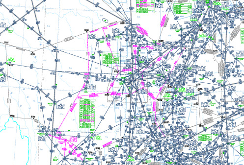
中国最新版民航航路图
(16) 29
172¡2511
(40) 73
4302
(45) 83 H10 3340
12185026(6044)¡
(18313)X6510853
H140
成都09扇
成都04扇
(133) 245 X97 6188
(113) 210 J139 6294
成都12扇 成都03扇
N33¡ã10'56 E102¡ã34'10
渭
112.8 TAS
TAS CH 75X
N34 33.9 E105 50.0
P29 N34 12.6 E106 33.5
528
(25) 46 2214 011¡
045¡4222(0203
G 18¡ 西西西安安安005 0扇 3扇89 80 90 0米 0米(不(含含)以 )以下上
西安进近
N34 25.9 E108 43.8
西安/咸阳 479
N34¡ã38'32 E109¡ã14'31
西安02扇88990000米米(( 不含含)以)以下上
潼关 E110¡ã15'00
临潼 烟庄
391 359 ZS
商县
(34) 62
N13331¡30.7H1324N 1 0 (3P133 4( 978 4 2 09¡H 8228 2 )(ã 4H 1 1 4)3 N E 1 /6. 1 332 1 3 3 )4 0 1294 19 E 0 9 ¡1 3240N E 0 28 1 5103 1 4 (3 00 1453 65 ¡. . U 9 88 7 1G . )3 N 4 N3 S3 5 3 4 U. 3 3 1 . 4 T6 1 C 3 2 (5 521H 4 2 . 92 3395 ). 5. 5 35 7 40¡01E 0E 71 51 S 0 0 2 R ¡9 9 H X AX 5 56 5. . 20 7 ( (1 65 R18009 Z )7563) L360¡0082(8H 735771 02N E ¡¡3 8)3 1 P1 514 2 0 267262 1 46955(0 2 (9745( 3248 7 318 1)灵. . )33 3 H口N ) E P1 街3 1P 6 1 13 0 NE3 23112405 3¡ 5 H¡6 5 ãã2N 3E . . 022 01 03 1 59'1 ' 134 0 0060028X0 3 71 41 1
1 Jeppsen航图解读

/train_dep/tuteach/ht.htm(第 1/28 页)2006-5-10 21:50:37
怎样读懂航图ห้องสมุดไป่ตู้料
1、机场平面图: 机场平面图包括 的内容有机场所在的国家,城市,机场的名称,地理坐标,机场标高,机场各通讯频率,跑到及滑行道平面图,进近灯光示意图,比例尺,磁 差,跑道信息等内容。此图为比例绘制。杰普森航图索引号一般以10开头。
怎样读懂航图资料
下面是两张目视飞行进近图
/train_dep/tuteach/ht.htm(第 27/28 页)2006-5-10 21:50:37
怎样读懂航图资料
作者:CFSO197 曹威 2003年4月21日 QQ: 91307 E-MAIL: WEI0672@
航空用图是民航情报服务部门根据飞行规则、飞机性能、空域情况等等内容统一绘制并发布,具有很强的时效性,并且具有法律效力的公文。中国民航自己的飞 行情报服务机构,负责航行资料、航行情报的汇总、发布,并随时进行数据信息的更新。现在民航飞行中使用的航图主要有杰普森航图,FAA航图,和各国根据自 己情况自己制作的航图!而以杰普森比较通用,(杰普森公司是一家专门经营航行情报服务的公司,它汇总各个国家提供的航行资料汇编[AIP]然后制作统一样式, 世界范围通用的航行资料,情报技术服务,飞行技术培训等)中国国内也制作CAAC自己的航图,我国制作的航图分为中文版和英文版两套,由于中文版航图涵盖 了一些军用信息,是国家保密的资料,因此在这里我们不做介绍,但它的制作基本结构采用了杰普森的航图样式!CAAC制作的英文版(即中国航行资料汇编AIP) 除了少数地方与杰普森的制作方式不同以外,其它均为通用,因此我使用杰普森航图进行说明! 首先,说说航图的分类。航图根据飞行规则分为:目视飞行用航图、仪表飞行用航图;根据空域划分分为:航路或航线用图(其中又包括高空航路图、中低空航 路图)、区域图、终端区图; 现在根据空域划分分类进行航图的介绍: 一、航路或航线图:为飞机进行航路或航线飞行时使用的航图,它主要包括了基本地形轮廓、飞行航路信息、航路代码、航路空域划分、航路飞行通讯频率、导 航台信息、经纬度坐标、限制性空域信息等于航路飞行有关的数据信息;一般分为高空航路图和中低空航路图。航路图的内容比较简单,稍看图例即可理解,因 此,在此不再细述; 二、区域图:区域图一般都是对某些飞行活动密集,空域复杂的地区的航路图进行的放大图,从而使涵盖的内容更加清晰、细致,内容基本与航路图相同,在此 也不做细述; 三、特殊航图:供特殊目的使用的航图,这里不做介绍! 四、航空地形图:这种航图主要提供飞行员进行地标参考使用,航图上立体的标画出地形地貌,山河湖海,重要山峰海拔高度,重要地标,重要障碍物海拔高度 等等,现在这种地图不太常用。 五、终端航图:这类航图包括很多种类。如:机场平面图、停机位图、标准进离港图、仪表进近图、放油区图、机场障碍物图、空中走廊图等;下面就对这些终 端区航图进行比较细致的说明!