雅思小作文地图题讲解
雅思写作地图题学生习作分析

雅思写作地图题学生习作分析地图题是雅思写作小作文部分烤鸭最不愿意碰上的一种提醒,很多人往往练动笔的思路都没有,不知道该从何入手,并且写完一部分内容不知道如何继续下一部分,该描述图中哪些有效信息。
下面是小编为您收集整理的雅思写作地图题学生习作分析,供大家参考!雅思写作地图题学生习作分析首先听题:Below is a map of the city of Brandfield. City planners have decided to build a new shopping mall for the area, and two sites, S1 and S2 have been proposed. Summarise the information by selecting and reporting the main features and make comparisons where relevant.第一个学生的写作:A golf course and park is located in the west of this city, with a river to the south, crossing Branfield from the south-western corner to the north. To the east of the golf course and park is a railway, linking he north-western corner and the south-eastern corner of this city. Situated in the north of Brandfield, a housing estate covers an area between the river and the railway. There is a city center in the middle of this city,located to the south of the railway and divided by the river.It is noticeable that a road is sited between the golf course and park in the west and the city center in the middle,and it goes across the south-eastern corner of the housing estate,connecting the north-eastern corner of this city to the south of the city center and to the south of this city. S1 is located to the north of the city center and the railway, between the road and the river.这个学生的作文主要问题是她上来不断地描述,而忘记了这个图的首要事情是描述S1 和S2. 这个学生的问题体现了中文和英文的思维差异。
雅思小作文地图题及词汇讲解

雅思小作文地图题及词汇讲解The map depicting the development of the village clearly illustrates the progress of this area。
It is divided into four main sectors with two main roads intersecting。
as well as one XXX roads.Part 1: TimeBoth flow charts and map XXX charts。
the n of the process is often expressed。
while in map ns。
time is used to show geographical changes。
Accurate time guidance not only increases the natural and coherent nature of the article。
but also reflects the n of the writing.Common time ns:In a few hoursDuring the d of。
After 10 daysFrom。
to。
XXX。
Over the。
year d5 years beforeOver the XXX。
yearsXXX sentence: The process lasts for up to 7 days and the products are finally distributed to customers.A decade earlier。
from that moment on。
after a while。
since。
since then。
finally.Part 2: SpaceSpatial n is more common in map ns。
雅思小作文地图题通用课件

对比两个时期的城市规划对居民生活和 经济发展的影响。
分析新旧规划在交通、绿化、公共设施 等方面的差异。
答案
描述旧区和新区的规划布局,如商业区 、住宅区、工业区的分布情况。
自然地理类模拟试题与答案
答案
描述地形地貌、河流走向、矿产 资源分布等情况。
分析这些自然地理特征对该地区 的经济活动和人口分布的影响。
描述变化和趋势的表达方式
变化
从...变为...、开始...后来...最终...等。
趋势
逐渐...、越来越...等。
04
地图题范文解析
城市规划类地图题范文解析
城市扩张
描述城市在不同时间点的边界 变化,解释城市扩张的原因和 影响。
交通规划
阐述城市交通网络的发展,包 括道路、地铁、公交等交通方 式的规划。
在雅思考试中,地图题的分数权重较高,通常占据写作总 分数的三分之一左右。因此,掌握地图题的写作技巧和方 法对于提高雅思写作成绩至关重要。
02
地图题写作技巧
确定地图变化的关键点
01
确定地图中需要重点关注的变化 点,如新建筑物的出现、道路的 改建、地形的变化等。
02
确定变化的数量和位置,以便在 写作中进行准确的描述和对比。
区域合作与一体化
讨论地图中不同地区之间的合作与一体化 进程,如交通、通讯等基础设施的互联互 通。
人口分布与迁移
指出地图中的人口分布特点,如密集区、 稀疏区等,并分析人口迁移的原因和影响 。
05
模拟试题与答案
城市规划类模拟试题与答案
模拟试题:提供了某城市的旧区与新区 规划图,要求考生对比分析两个时期的 城市规划特点。
02
地形变化
分析地图中地形的变化,如山丘、河 流、湖泊等,以及它们对当地环境和 居民的影响。
雅思地图小作文7分范文:村庄的变迁

雅思地图小作文 7 分范文:村庄的变迁地图题The map below shows the development of the village of Ryemouth between 1995 and present. Write a report based on the map.题目来源:2021 年 4 月29 日大陆雅思小作文1 题目大意下面的地图显示了从1995 年到现在Ryemouth 村的发展情况。
根据地图写一份报告。
2 高分范文示例开始段 - 改写题目The map given illustrates the reconstruction of the village of Ryemouth between 1995 and present.主体段段-1: 切割法---主路 1In 1995,there was a main road, extending from the northwest to the southeast,with several houses nearby. A small residental area can also be noticed in the middle block,linking to this road. To the east of this road were located the farmland and forest park. Currently, the residental block almost remain the same, while the original agriculture and natural scenery aresubstituted by the entertaining area dominated by golf and tennis.主体段 2: 切割法---主路 2Another street, stretching from the west to the east, was sited adjacent to the coast, which meets the main road with a hotel around the corner and a cafe opposite to it. Several shops and fish markets could be seen to the both sides of the street,while the fishing port can also be accessed in the past. However, the southern area has altered considerably since 1995. The original harbor is demolished, with the previous supporting facilities all replaced by restaurants and apartments respectively. It is noticeable that a parking lot is newly constructed just off the hotel.结尾:整体概述In summary,the function of infrastructures in the village has changed from serving agriculture and fishery to entertainment and related supporting facilities.。
作文范文之雅思小作文地图题怎么写

雅思小作文地图题怎么写【篇一:雅思小作文地图题讲解】一个地图题的开头:the map about the development of the village sufficiently illustrates the way of progress of this area. in this map, we can find four main sectors and two main roads intersected withone railway and one motor way. it seems the overall development of this village has strong connection with the construction of roads.雅思小作文地图题词汇part 1:表时间流程图和地图题中都可能涉及时间表达。
流程题中,使用较多的是过程时长的表述,而地图题的时间使用则体现为地理变迁的时间变化。
一般在方位选址图题中较少出现。
确切的时间指引,既增加文章的自然和连贯度,也能体现行文的精确性。
常见表示时间的词:in few hours几小时during the period of … 在…期间after 10 days 10天后from…to 从…到…between …and 在…之间over the…year period在一个…年期间5 years before 5年前over the subsequent …years近连续几年例句:the process lasts for up to 7 days and the products are finally distributed to customers.a decade earlier几十年前 from that moment on从那时起 after a while一会 since自从 since then自从 finally最后part 2:表空间空间表达地图题出现概率较高,但流程图也偶尔出现。
最新雅思小作文地图题讲解-精选.pdf

一个地图题的开头:The map about the development of the village sufficiently illustrates the way of progress of this area. In this map, we can find four main sectors and two main roads intersected with one railway and one motor way. It seems t he overall development of this village has strong connection with the construction of roads.雅思小作文地图题词汇Part 1:表时间流程图和地图题中都可能涉及时间表达。
流程题中,使用较多的是过程时长的表述,而地图题的时间使用则体现为地理变迁的时间变化。
一般在方位选址图题中较少出现。
确切的时间指引,既增加文章的自然和连贯度,也能体现行文的精确性。
常见表示时间的词:in few hours几小时during the period of …在…期间after 10 days 10天后from…to从…到…between …and在…之间over the…year period在一个…年期间5 years before 5年前a decade earlier几十年前from that moment on从那时起after a while一会since自从since then自从finally最后over the subsequent …years近连续几年例句:The process lasts for up to 7 day s and the products are finally distributedto customers.Part 2:表空间空间表达地图题出现概率较高,但流程图也偶尔出现。
雅思小作文地图题之地理变迁题高分范文

雅思小作文地图题之地理变迁题高分范文雅思小作文地图题主要包括选址类与地理变迁类两大类型,今天小编就给大家介绍下雅思小作文地图题之地理变迁题高分范文。
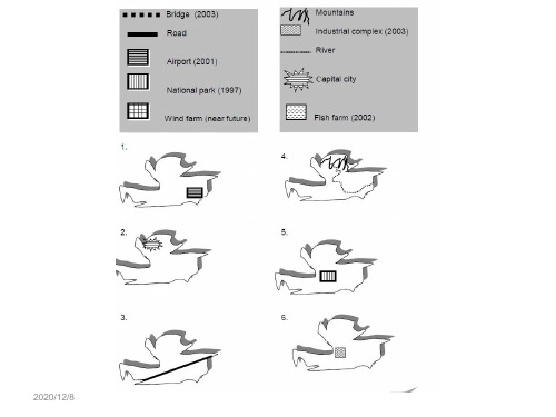
雅思地理变迁题范文篇1题目:剑桥雅思官方指南中T est 7 Task 1的作文,原题目是The map below shows the village of Stokeford in 1930 and in 2010.从题目可知,该题为地图题,主要有两张地图组成,属于地理变迁类。
题目描述的是Stokeford村庄在1930年和2010年的发展变化。
地理变迁题的写作,考生要根据时间以及空间顺序来写,小作文的写作还要格外注意时态与语态。
从图中得知,没有变化的是横跨河流的桥梁以及邮局的位置,而有所变化的是商店,农场没有了;新增几条支路以及很多住宅;花园被改建成了养老院;学校的规模也扩大了。
因此,从变化中,我们在写主体段的时候可以分别描述这个村庄在1930年和2010年的发展变化较好写一些。
下面,我们来具体看看每个段落的详细内容以及进行分析。
第一段描写的是第一张地图的内容:先整体描述在1930年,River Stoke贯穿了Stokeford村庄的东北角到西南角,地图上显示有一座桥,连接河流两岸地区。
In 1930, the River Stoke crossed through the Stokeford from northeast corner to southwest corner and a bridge in the top was over this river for providing the path for the road in this map.第二段主要描述的是第二幅图的内容,即70年后该村庄的发展变化。
最后,小编将范文分享给大家,考生们可以参照学习学习。
In 1930, the River Stoke crossed through the Stokeford from northeast corner to southwest corner and a bridge in the top was over this river for providing the path for the road in this map. It is obvious that there is nothing in the west side of the river.Moving to the eastside of the river stoke, the primary school was right in the center of the maps well as next to the farmland. To the south side of the primary school was the gardens with a large house. Besides, along the road from north to south, several buildings, shops, post office and farmland were located in the west side of it.After 70 years, as can be seen from the map of 2010, there was no change happened in the west side of the river and about the post office, but all of the farmlands and shops had been demolished. Moreover, the primary school had been expanded with two buildings and to the south of which, the original gardens had been reduced and developed as the retirement home.Lastly, several branches of the road had been constructed with plenty of houses, which had been established along branches.雅思地理变迁题范文篇2The two maps below show an island before and after the construction of some tourist facilities.Summarise the information by selecting and reporting the main features, and make comparisons where relevant.Write at least 150 Words.参考范文The two maps demonstrate the changes made to an island after it was turned into a tourist resort.The holiday resort which occupied about three quarter of the island consists of a reception building, a restaurant, and numerous chalets; all located within a walking distance. In addition, the reception area is also connected directly to a newly built pier which made it more accessible by visitors. For the convenience of the guests, a vehicle track that connects the pier,the reception and the restaurant was also constructed.To further promote the island as a holiday attraction, various spots of the island have been upgraded for recreational activities. For example, swimming is now available at the beach near the west end of the island and sailing can be done near the pier of the resort.Overall, the transformation of the island into a vacation spot has brought much improvements to the island without any deforestation. As a matter of fact, there are now more trees in the island than before.雅思地理变迁题范文篇3话题:The map shows the village of Chorleywood showing development between 1868 and 1994范文The map shows the growth of a village called Chorleywood between 1868 and 1994.It is clear that the village grew as the transport infrastructure was improved. Four periods of development are shown on the map, and each of the populated areas is near to the main roads, the railway or the motorway.From 1868 to 1883, Chorleywood covered a small area next to one of the main roads. Chorleywood Park and Golf Course is now located next to this original village area. The village grew along the main road to the south between 1883 and 1922, and in 1909 a railway line was built crossing this area from west to east. Chorleywood station is in this part of the village.The expansion of Chorleywood continued to the east and west alongside the railway line until 1970. At that time, a motorway was built to the east of the village, and from 1970 to 1994, further development of the village took place aroundmotorway intersections with the railway and one of the main roads.雅思地理变迁题范文篇4The map below shows the development of a seaside village between 1995 and present.Write a short report for a university lecturer describing the information shown below.Write at least 150 words.参考范文:The two maps show the layout of the same seaside village in 1995 and at present.Overall, it is evident that the infrastructure for housing and recreation has increased at the expense of agricultural land and commercial fishing.The most notable changes are the disappearance of the fishing port and adjacent fish market, as well as the creation of a golf course and tennis courts in the north-east, where farmland and a forest park were still found in 1995. Furthermore, a new housing development containing apartments is now found on the waterfront at the former site of the fish market, and a number of restaurants have been built on the opposite side of the road where shops used to be.There was also an increase in the total number of houses, from 12 in 1995 to 16 at present. In addition, the road encircling a small housing development west of the main road has been extended further westward.The hotel and cafe in the south-east have remained as is. A new car park has been added next to the hotel.雅思地理变迁题范文篇5The maps illustrate how Meadowside village and Fonton, which is a neighbouring town, have developed over threedifferent time periods (1962, 1985 and the present).范文:Overall, Meadowside village increased in size and has become Meadowside Suburb as it merged together with Fonton. Furthermore, there have been significant changes in infrastructure, housing and facilities over the period given.In 1962, both Meadowside and Fonton were completely separate with no roads or rail connecting them. While Fonton had a railway line running through it to the north, Meadowside, located to the west of Fonton, only had a small road from the west.By 1985, there was a considerable growth in the size of Meadowside village and Fonton. The small road in Meadowside village had been converted into a main road and was also extended to the east to connect with Fonton. Meadowside, moreover, had also developed a housing estate in the west, a leisure complex and a supermarket in the south.Currently, both Meadowside, which is now a suburb, and Fonton are joined. The railway line, which runs through Fonton, has been extended to the west where a train station has been built. To the north of the station, a hotel has been constructed and opposite the station, to the south, there is now a business park.。
雅思考试-地图题讲解和范文

• Finally, the cool climate house has one window which faces the direction of the sun, while the warm climate house has windows on two sides which are shaded from the sun. By opening the two windows at night, the house designed for warm climates can be ventilated.
• The diagrams show how house designs differ according to climate.
• The most noticeable difference between houses designed for cool and warm climates is in the shape of the roof. The designs also differ with regard to the windows and the use of insulation.
• 4. 对比介词短语 • By contrast
• In contrast
• On the contrary 绝其实还可能用到变化句型
• 1). There will be an increase in the size of the exhibiting hall.
• At present, visitors enter the gallery through doors which lead into a lobby. However, the plan is to move the entrance to the Parkinson Court side of the building, and visitors will walk straight into the exhibition area. In place of the lobby and office areas, which are shown on the existing plan, the new gallery plan shows an education area and a small storage area.
- 1、下载文档前请自行甄别文档内容的完整性,平台不提供额外的编辑、内容补充、找答案等附加服务。
- 2、"仅部分预览"的文档,不可在线预览部分如存在完整性等问题,可反馈申请退款(可完整预览的文档不适用该条件!)。
- 3、如文档侵犯您的权益,请联系客服反馈,我们会尽快为您处理(人工客服工作时间:9:00-18:30)。
一个地图题的开头:The map about the development of the village sufficiently illustrates the way of progress of this area. In this map, we can find four main sectors and two main roads intersected with one railway and one motor way. It seems the overall development of this village has strong connection with the construction of roads.雅思小作文地图题词汇Part 1:表时间流程图和地图题中都可能涉及时间表达。
流程题中,使用较多的是过程时长的表述,而地图题的时间使用则体现为地理变迁的时间变化。
一般在方位选址图题中较少出现。
确切的时间指引,既增加文章的自然和连贯度,也能体现行文的精确性。
常见表示时间的词:in few hours几小时during the period of …在…期间after 10 days 10天后from…to从…到…between …and在…之间over the…year period在一个…年期间5 years before 5年前a decade earlier几十年前from that moment on从那时起after a while一会since自从since then自从finally最后over the subsequent …years近连续几年例句:The process lasts for up to 7 day s and the products are finally distributed to customers.Part 2:表空间空间表达地图题出现概率较高,但流程图也偶尔出现。
空间应该是地图题解题关键和主要特点。
许多考生容易误把地图题的空间位置写成上下左右位置,这是失分点非常大的地方。
朗阁海外考试研究中心的专家们提示烤鸭,空间表达时需要注意区分:在空间状语里,in表内部,on表接壤,to表分开。
常用的空间词:lies 靠近is located 坐落is situated in 位于across 交叉parallel 平行intersect 交点on the …side of the …面on both sides of 两边just off …靠近on the opposite side 在另一边on the border 在边缘上center/middle/central area 中间near/next to/close to/adjacent to 靠近例句:It lies 450 kilometers from the nearest city, which is on the north side of the KK mountain.Part 3:表顺序表顺序的使用在流程图中是典型,表顺序的关联词能够使描述的流程更加清晰,结构条理明显。
就如我们常用的产品安装说明一样,标明了1、2、3、4步,简洁明了。
常见的表顺序的连词如下:开始:first of all, initially, to begin with, in the first place, first, the first stage involves …, during, in the first place, Firstly?其次:second, then, next, also, in the second stage, following this/that, afterwards the first (reason) is, Secondly然后:after that, at the same time, in the meantime, meanwhile, prior to, until, in the third stage, in addition, at the same time, from that moment on, once when最终:finally, lastly, in the final stage, in the end, Thirdly例句:First the fruit is picked from trees by hand. It is then transported to the cannery by large trucks.A.地图变化词变大:enlarged extended increasedsoarby halfrisendoubled, tripled 变小:dropped reduced decreasedgrownfallenhalved消失:disappeared removed no more here 建成:Becomes transformed reconstructedredevelopedcompleted and openedadded to the libraryconverted into changed intoturned over to replaced /substituted gives way tonewly-builtbuiltestablishset upconstructedThe following diagraph shows the structure of……?The picture illustrates……?It mainly consists of…….?It works as follows……?It always involves following steps…….?The whole procedure can be divided in……….stages.?地图题第一段句型This report compares how _______ developed and changed since ________/ between ____ and ____.The two maps illustrate the difference of _______ between ____ and _____.表示A位于……A is located …A is situated …A is just off the road to … A在通向某地的路边上A is right at the center of … A在……的正中央表示A靠近或紧挨着BA is next to BA is close to BA is adjacent to B表示A位于B的某一面……公里处A is located/situated … kilometers to the east/west/south/north of B.表示A在B的某个角上A is located on the east/west/north/south corner of B表示道路/河流通向某处The road runs from … to …The river flows from … to …表示A与B一路之隔A is right across from B表示A在B的对面A is opposite B表示建筑物的布局: layout表示建筑物周边的环境:the surroundings 表示A占据了某个空间: A occupies…表示在某处新建造了AA is newly built inA is newly constructed inA is newly established in表示A被改造成了BA is turned into BA is transformed into BA is replaced by B表示A被移除A is removedA has goneA is taken down from …表示A的面积缩小/扩大了The size of A is reduced/expanded.A was expanded to twice its size.The size of A almost doubled.A经历了(某种变化): A experienced/witnessed/saw…起初:At first/Initially/In the beginning/Originally,接下来:Then/Next/After that/In the following stage/In the next period/In the subsequent period/Afterwards,在这个阶段:At this point/In this phase/In this stage,最终:Finally/Eventually/In the end,地图题的5个常用句式(前三个句子为主,后面的句子为连接和点缀)句式1:located/situated/sited/built/constructed+地点1. ,一块湿地(wetland)在湖的西南面。
A wetland is located to the southeast of the lack.句式2:地点+with+地点+方位2. 这个地区有一个很大的树林,在南面有一个农场。
This region has large woodland with a farm to the south.句式3:there be 句型3. 东南角有两个学校。
There are two schools on the south-eastern corner of the area.句式4:使用while, but 和and连接的句子4. 城市的北面有一个山,而南面有一个湖A mountain is located to the north of the city, while there is a river to the south.句式5:倒装句5. 河的南面有个博物馆。
To the south of the river was a library.句式6:使用名词性从句(譬如说it should be noted that, it is worth noting that, it is noticeable that, we can see that, it is clear that, one significant change is that)6. 值得注意的是这个图书馆在东侧有一长列的会议室。
