spatialtools空间分析工具介绍
空间分析建模

12.3.3 创建脚本文件
1.单数据处理 2. 批处理
1.单数据处理
(1) 概念 所谓单数据处理,是指处理过程中只涉及到单个数据集的处理,数据可以是栅格数据集、ArcView的shapefile也可以是Arc/Info的coverage等
(2)实现 第一步:编写脚本 第二步:在ArcToolbox中添加script 第三步:设置script属性 第四步:运行脚本
输入2
输出3
复杂处理工具模型
图12.5 复杂处理工具模型处理过程
12.2.2 模型生成器组成
1. 模型构造器界面 2. 模型构造器菜单 3. 模型构造器工具图标 4. 实例分析
1.模型构造器界面
图12.6 模型构ห้องสมุดไป่ตู้器的初始界面
2.模型构造器菜单
利用DEM来提取水系:对于与地表水文情况有关的许多领域如区域规划、农业、林业等有十分重要意义
1.建立概念模型 分析: 1)问题的抽象和简化:模拟地表径流在地表的流动来产生水系。 2)前提、假设:此处DEM的洼地均为可填充型洼地。 3)涉及的参数和变量:填充后的无洼地DEM、DEM每个栅格单元的水流方向、每个栅格上游汇水面积、确定水系的阈值大小。 4)数据类型的转换:由于基于DEM的计算都是栅格数据,故需要将水系栅格数据转换为矢量数据。
2.批处理
(1)概念 所谓批处理是指一次操作多个同样格式数据的过程。 脚本提供了一种便捷的方式用于批处理,数据转换以及任何空间处理工具的使用。 要进行批处理,只要在脚本中加入循环语句即可。
(2)实现 第一步:编写脚本 第二步:在ArcToolbox中添加script 第三步:运行脚本
4.运行结果
(b) 汇流累计大于1000的河网
空间分析——栅格数据的空间分析(一)

重分类娱乐场所直线距离数据集
娱乐场所近~远 对应于 适宜度10~1
重分类现有学校直线距离数据集
新学校距离现有学校比较远时适宜性好,仍分 为10级,距离学校最远的单元赋值为10,距离学校 最近的单元赋值为1。得到重分类学校距离图。
重分类土地利用数据集
土地利用对新建学校的适宜性有一定的影响。 如在有湿地、水体分布区建学校的适宜性极差,于 是在重分类时删除这两类,然后对剩下的其它土地 利用类型重新赋值。 赋值如下:
(一)背景
合理的学校空间位置布局,有利于学生的上课
与生活。学校的选址问题需要考虑地理位置、学生
娱乐场所配套、与现有学校的距离间隔等因素,从
总体上把握这些因素能够确定出适宜性比较好的学 校选址区。
(二)目的
通过练习,熟悉ArcGIS栅格数据距离制图、
成本距离加权、数据重分类、多层面合并等空间 分析功能;熟练掌握利用ArcGIS空间分析功能, 分析类似学校选址等实际应用问题。
密度制图
密度制图根据输入的要素数据集计算整 个区域的数据聚集状况,从而产生一个连续 的密度表面。密度制图主要是基于点数据生 成的,以每个待计算格网点为中心,进行圆 形区域的搜寻,进而来计算每个格网点的密 度值。
表面分析
表面分析主要生成新的数据集,诸如等 值线、坡度、坡向、山体阴影等派生数据, 获得更多的反映原始数据集所暗含的空间特 征、空间格局等信息。
表面分析的功能有:查询表面值、从表 面获取坡度和坡向信息、创建等值线、面积 和体积、数据重分类、将表面转化为矢量数 据等。
统计分析
是基于栅格数据的一种空间统计分析,包括
基于单元的统计(cell statistics)、邻域统计、 分类区统计等内容。
arcgis提取点的坐标

arcgis提取点的坐标【原创版】目录1.ArcGIS 简介2.提取点坐标的方法3.提取点坐标的实际应用正文一、ArcGIS 简介ArcGIS 是一款由美国环境系统研究所(Esri)公司开发的地理信息系统(GIS)软件。
它被广泛应用于地理空间数据的处理、分析和管理,为各行各业提供了强大的地理信息服务。
在 ArcGIS 中,用户可以利用各种工具和函数完成空间数据的操作和处理。
二、提取点坐标的方法在 ArcGIS 中,提取点坐标主要可以通过以下几种方法实现:1.利用“要素提取”工具:在 ArcToolbox 中,选择“Spatial Analyst Tools”工具集,找到“要素提取”工具。
通过该工具,用户可以根据设定的条件提取出点要素。
2.利用“地理处理”工具:在 ArcToolbox 中,选择“GeoProcessing Tools”工具集,找到“地理处理”工具。
通过该工具,用户可以编写自定义的脚本,实现对点坐标的提取。
3.利用“场”计算:在 ArcGIS 中,可以利用“场”计算功能,根据设定的条件计算出点的坐标。
例如,可以利用“聚合点”函数,根据设定的聚合半径和类型,计算出点坐标。
三、提取点坐标的实际应用提取点坐标在实际应用中有很多场景,例如:1.基于点的兴趣点分析:通过对城市中的点坐标提取,可以分析城市的人口分布、商业设施分布等,为城市规划提供参考。
2.基于点的设施布局优化:通过对设施点坐标的提取,可以分析设施的服务范围、覆盖情况等,为设施布局优化提供依据。
3.基于点的生态保护规划:通过对生态保护点坐标的提取,可以分析生态保护设施的分布、保护范围等,为生态保护规划提供支持。
arcgis 计算面内的点数目

arcgis 计算面内的点数目摘要:1.引言2.ArcGIS 简介3.计算面内的点数目的方法4.具体操作步骤5.总结正文:【引言】在GIS(地理信息系统)领域,ArcGIS 是一款非常受欢迎的地理信息分析软件。
许多GIS 从业者需要对空间数据进行各种复杂的分析,其中计算面内的点数目是一种常见的需求。
本文将介绍如何使用ArcGIS 进行这种计算。
【ArcGIS 简介】ArcGIS 是由美国环境系统研究所(Esri)开发的一款地理信息系统软件。
它具有强大的空间数据处理、分析和管理功能,被广泛应用于城市规划、环境保护、资源管理等领域。
【计算面内的点数目的方法】在ArcGIS 中,计算面内的点数目主要可以通过两种方法实现:一种是使用“要素统计”工具,另一种是使用“空间连接”工具。
【具体操作步骤】方法一:使用“要素统计”工具1.打开ArcGIS 软件,加载需要进行点数目计算的shapefile 文件。
2.在“ArcToolbox”中,找到“Spatial Analyst Tools”工具集,然后选择“Area”工具,输入面要素(如多边形、矩形等),计算其面积。
3.接着,在“Spatial Analyst Tools”工具集中,找到“Element”工具,输入点要素,计算其数量。
方法二:使用“空间连接”工具1.创建一个新的shapefile 文件,将需要计算点数目的面要素和点要素分别输入到该文件中。
2.在“ArcToolbox”中,找到“Spatial Analyst Tools”工具集,然后选择“Spatial Join”工具,将面要素与点要素进行连接。
3.连接完成后,查看连接结果,可以发现连接成功的点要素数量即为面内的点数目。
【总结】通过以上两种方法,我们可以在ArcGIS 中轻松地计算面内的点数目。
需要注意的是,根据具体的数据和需求,可以选择适合的方法进行计算。
地学统计分析-莫兰指数【精选文档】

莫兰指数一、分析步骤1、ArcGIS中,工具在如下位置:Spatial Statistics Tools ——Analyzing Patterns ——Spatial Autocorrelation(Moran’s I)2、参数设置用距离来对空间概念进行的描述的方式,就是所谓的空间关系的概念化.选择了CONTIGUITY_EDGES_CORNERS,共边共点都被视为邻接要素.3、在结果栏中,双击生成的*.html的页面,弹出如下三、数据分析1、理论知识(1)零假设(null hypothesis),有时候又称原假设,你在检验你的结果之前,先对这些结果假设一个数值区间,这个区间一般是符合某种概率分布的情况,如果你的真实结果偏离了你设定的区间,就表示发生了小概率事件。
这样你原来的假设就不成立了。
如果你的计算结果落在—2到2之间,就表示你的假设是可以接受得,但是不在这个范围内,就说明消息小概率事件了。
既然有小概率事件,就说明两种可能:1,你的假设有错误;2,出现了异常值。
(2)p值和Z得分p值代表数据来源的可靠性,z得分和莫兰指数都表示此数据有明显的规律。
p值(P-Value,Probability,Pr),代表的是概率。
它是反映某一事件发生的可能性大小。
在空间相关性的分析中,p值表示所观测到的空间模式是由某一随机过程创建而成的概率。
如果是0.1,就表示只有10%的可能性是随机生成的结果。
P值要小于0.1.标准差能反映一个数据集的离散程度,Z得分,就是标准差的倍数(有正负之分)(3)置信度要进行数据分析,我们首先就要设立一个置信度,也就是说,你要设定你的数据,起码要有多大的可能性,被落在你期望的区间内.2、结果分析①数据分布出现显著的随机分布特性,无法拒绝零假设,无分析价值。
②数据分布仅有小于10%的可能是随机分布的,出现数据聚集的可能性大于随机分布的可能性,但是不能显著的拒绝零假设。
(p值为0.09)③数据分布仅有小于5%的可能是随机分布的,出现数据聚集的可能性大于随机分布的可能,且能够显著的拒绝零假设.此结果表示XX数据的空间分布,出现一定的聚集特征,且具有空间正相关模式,用于分析的值与空间聚集度成正比。
arctoolbox介绍
• 一旦被保存,模型能够像其它任何工具一样使用对话框来执行。 • 一个模型可以在任何时间被编辑,只要有合适的权限。
– 在空间数据库中的模型工具能够被赋予专门的用户权限。
• ArcGIS 9.0 有450多个空间处 理工具
– 分析
• 联合、裁剪、相交、判别、拆分 • 缓冲区、近邻、点距离 • 频度、加和统计
– 数据管理
• 字段、索引、值域、子类型和工作空 间的管理 • 投影 • 空间数据库版本、关系类和拓扑 • 栅格管理 • 图层、视图、关联和选择集 • 综合(融合) • 要素操纵工具 • 数据集管理(创建、复制、删除和重 命名)
地理编码工具 – 7 3D分析工具 – 45 线性参考 – 7 制图工具 - 3 Coverage工具 – 57
– 分析、数据管理和转换 – 使用Workstation执行
空间处理 – 框架
对话框 … 脚本 …
模型 … 命令 …
Geoprocessing Options
Geoprocessing Environment
Learning About Tools
Desktop Help
Tool Help
ArcToolBox的管理
• 可通过添加Tool或Scripts
• 可创建新的Toolset和Model
• 可把定制的Model或工具用文件或ArcSDE数据库 保存
二、空间分析的基本概念与常见的矢量空间分析
工具
• 转换工具 - 25
– 新工具用来转换featureclasses到ArcInfo Coverages – 基于工作空间的方法
• 空间分析工具 – 158
– 几乎所有的 ArcInfo Workstation Grid功能 被支持 – 新的 Weighted Overlay 工具
ArcGIS英汉对照
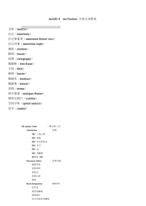
ArcGIS 9 ArcToolbox 中英文对照表分析(analysis)注记(annotation)注记要素类(annotation feature class)注记对象(annotation target)属性(attribute)障碍(barrier)绘图(cartography)数据框(data frame)字段(field)障碍(barrier)数据库(database)数据集(dataset)范围(extent)组合要素(multipart feature)图形比例尺(scalebar)空间分析(spatial analysis)符号(symbol)3D Analyst Tools 三维分析工具转换ConversionTIN 三角计算TIN 域值TIN 多边形标志TIN 节点TIN 边TIN 到栅格栅格转TINFunctional Surface 表面功能插值形状表面体积表面点表面长度视线Raster Interpolation 栅格修补克里金地形到栅格曲线拟合用文件地形到栅格自然邻域趋势距离权重倒数Raster Math乘减加取整浮点除Raster Reclass切片查找用ASCII 文件重分类用表重分类重分类Raster Surface坡向坡度填/挖山影曲率栅格计算栅格重分类栅格表面等高线等高线列表观察点视域TIN Creation创建TIN编辑TINTIN SurfaceTIN 坡度TIN 方位TIN 等高线多边形插值成多个面Analysis Tool:ExtractClipSelectSplitTable Select OverlayEraseIdentityIntersect TIN 创建TIN 表面分析工具提取剪切选择拆分表选择叠加分析擦除查看相交Symmetrical Difference 对称差UnionUpdate ProximityBufferMultiple RingBufferNearPoint Distance StatisticsFrequencySummaryStatistics联合更新邻域分析缓冲区多环缓冲区临近点距离统计表频度总结统计Cartography Tool:Masking ToolsCul-De-SacMasks 绘图工具掩模工具Cul-De-Sac 掩模Feature Outline Masks 要素轮廓线掩模Intersecting Layers Masks 相交图层掩模Conversion Tool:From RasterRaster to ASCII 转换工具从删格到...删格到ASCIIRaster to FloatRaster to PointRaster to PolygonRaster to Polyline To CADAdd CAD FieldsCreate CAD XDataExport to CADSet CAD AliasTo Coverage删格到浮点删格到点删格到面删格到线到CAD添加CAD 字段创建CAD 扩展实体数据导出到CAD设置CAD 别名到CoverageFeature Class To Coverage 要素类到CoverageTo dBASE 到dBASETable to dBASE [multiple] 表到dBASETo GeodatabaSEFeature Class To Feature Class要素类到要素类Feature Class to Geodatabase [multiple] 要素类到GeodatabaseImport CAD AnnotationImport Coverage AnnotationImport from CADRaster To Geodatabase[multiple]Table to Geodatabase[multiple]Table To TableTo Raster 到栅格ASCII to Raster ASCII 到栅格DEM to Raster DEM 到栅格Feature to Raster 要素到栅格Float to Raster 浮点到栅格导入CAD 注记导入Coverage 注记从CAD 导入栅格到Geodatabase 表到Geodatabase 表到表Raster To Other Format 栅格到其他格式To Shapefile 到ShapefileFeature Class To Shapefile 要素类到Shapefile Coverage Tool: Coverage 工具AnalysisExtractClipSelectSplitOverlayErase 分析提取剪切选择拆分叠加擦除IdentityIntersectUnionUpdate Proximity判别相交联合更新邻近BufferNearPoint DistancePoint NodeThiessen Conversion 转换From CoverageExport To DLG缓冲近邻点距离点到结点泰森近似多边形从Coverage到DLGExport To Interchange File 到Interchange 文件Export To S57Export To SETSExport To VPFUngenerateTo Coverage到S57到SETS到VPF取消生成到CoverageAdvanced Tiger Conversion 高级Tiger 转换Basic Tiger Conversion 基本Tiger 转换GenerateImport From DLG 生成从DLG 导入Import From Interchange File 从Interchange 文件导入Import From S57Import FromSETSImort From VPF Data ManagementAggregateAppend从S57 导入从SETS 导入从VPF 导入数据管理集合追加Composite Features 要素合成Line Coverage To Region 线Coverage 到区域Line Coverage To Route 线Coverage 到路径Polygon Coverage To Region 多边形Coverage 到区域Region To Polygon Coverage 区域到多边形Coverage Generalization 一般Aggregate Polygons 聚集多边形Collapse Dual Lines To Centerline 分解双线到中心线Dissolve EliminateFind Conflicts Simplify Building 融合消除查找冲突简化建筑物Simplify Line Or Polygon 简化线或多边形IndexesDrop IndexIndex Item ItemsAdd ItemDrop Item 索引项删除索引索引项添加项删除项Joins Join Info Tables Projections 连接 投影连接 Info 表 Define Projection Project Transform Tables 表 Add XY Coordinates Renumber Nodes Update IDs Tolerances 容差 Tolerance Topology 拓扑 Build Clean Create Labels VPF Tile Topology 定义投影投影变换 添加 XY 坐标重新计数节点更新 ID容差构建Clean创建标注VPF 图块拓扑Workspace Management 工作空间管理Create Coverage Data Management Tools 数据管理工具 Database 数据库 Compact Compress Disconnected Editing 分离编辑 Check In Check In From Delta Check Out Export To Delta Domains 值域 Add Coded Value To Domain Assign Domain To FieldCreate Domain创建 Coverage紧凑 压缩检入 从增量中检入 检出 导出增量 添加编码值到值域 赋值值域到字段 创建值域 Delete Coded Value From Domain 从值域中删除编码值 Delete Domain Domain To Table Remove Domain From Field Set Value For Range Domain Table To Domain Feature class 要素类删除值域值域到表从字段删除值域为范围值域设置值表到值域Append Annotation Feature Classes 追加注记要素类 Calculate Default Cluster Tolerance 计算缺省容限值Calculate Default Spatial Grid Index 计算缺省空间格网索引 Integrate 整合Update Annotation Feature Class 更新标记要素类创建要素类Features 要素创建要素类Add XY Coordinates Check Geometry Copy Features Delete Features 添加XY 坐标检查几何形状复制要素删除要素Feature Envelope to Polygon 要素封装到多边形Feature To LineFeature To PointFeature To PolygonFeature Vertices To PointsMultipart To SinglepartPolygon To LineRepair GeometrySplit Line At Vertices Fields 字段Add FieldAssign Default To FieldCalculate FieldDelete FieldGeneral 一般CopyDeleteRenameSelect Data追加Generalization 一般DissolveEliminateSimplify LineSmooth LineIndexes 索引Add Attribute IndexAdd Spatial IndexRemove Attribute IndexRemove Spatial Index Joins 连接Add JoinRemove Join 要素到线要素到点要素到多边形要素定点到点多部分到单部分多边形到线修改集合形状在定点拆分线添加字段设置缺省到字段计算字段删除字段复制删除重命名选择数据追加融合消除简化线平滑线添加属性索引添加空间索引删除属性索引删除空间索引添加连接删除连接Layers and Table Views 图层和表的查看Make Query TableMake Raster Catalog Layer Make Raster Layer 制作查询表制作栅格目录图层制作栅格图层Make XY Event Layer Save To Layer File Select Layer By Attribute Select Layer By Location 制作表视图制作要素图层制作XY 事件图层保存成图层文件通过属性选择通过位置选择制作表视图制作要素图层Projections and Transformations 投影和转换FeatureBatch ProjectProject创建空间参考RasterFlipMirrorProject RasterRescaleRotateShiftWarDefine ProjectionRasterBatch BuildPyramids 栅格要素批量投影投影创建空间参考栅格翻转镜像投影栅格重建比例旋转偏移翘曲定义投影批量建立金字塔Batch Calculate Statistics Build Pyramids Calculate StatisticsClipComposite BandsCopy RasterCopy Raster Catalog Items Create Raster Catalog 批量计算统计表建立金字塔计算统计表剪切组合波段复制栅格复制栅格目录项创建栅格目录Delete Raster Catalog Items 删除栅格目录项Mosaic To NewRasterResample创建栅格数据集镶嵌Relationship Classes 关系类镶嵌到新的栅格重采样创建栅格数据集镶嵌Create Relationship Class 创建关系类Table To Relationship Class 表到关系类SubtypesAdd SubtypeRemove SubtypeSet Default SubtypeSet Subtype Field Table 子类型表添加子类型删除子类型设置缺省子类型设置子类型字段Analyze Change Privileges Copy Rows Delete Rows Get Count Pivot Table 创建表 Topology 拓扑分析改变权限复制行删除行获得数目关联表创建表Add Feature Class To Topology 添加要素类型到拓扑 Add Rule To Topology Create Topology 添加规则到拓扑创建拓扑Remove Feature Class From Topology 从拓扑删除要素类 Remove Rule From Topology Set Cluster Tolerance Validate Topology Versions 版本 Alter Version Create Version Delete Version Post Version Reconcile Version Register As Versioned Unregister As Versioned Workspace 工作空间 Create ArcInfo Workspace Create Feature Dataset Create Folder Create Personal GDB 从拓扑中删除规则设置簇容限值教验拓扑 改变版本创建版本删除版本提交版本协调版本注册版本取消注册创建 ArcInfo 工作空间创建要素数据集创建文件夹创建个人 Geodatabase Geocoding Tools Automate Geocoding IndexesCreate Address Locator地理编码工具自动生成地理编码索引创建地址定位器 Deautomate Geocoding Indexes Delete Address Locator Geocode Addresses Rebuild Geocoding Indexes Standardize Addresses 取消自动生成地理编码索引 删除地址定位器地理编码地址重建地理编码索引 标准化地址 Geostatistical Analyst Tools 地理统计分析工具Geostatistical Layer To Grid 导出地理统计图层到 Grid Linear Referencing Tools Calibrate Routes Create Routes Dissolve Route Events 线性参考工具校准路径创建路径融合路径事件Locate Features Along Routes 沿路径定位要素边界清理Make Route Event LayerOverlay Route EventsTransform Route EventsSpatial Analyst ToolsConditional 条件拾取条件设空Density 密度核密度点密度线密度Distance 距离代价分配代价回联代价距离代价路径欧几里德分配欧几里德方向欧几里德距离走廊路径距离路径距离分配路径距离回联Extraction 提取提取值到点根据属性提取用圆提取用多边形提取用掩模提取用点提取用矩形提取采样Generalization 一般区块组合多数过滤收缩消蚀细化聚合膨胀制作路径事件图层空间分析工具叠加路径事件转换路径事件Groundwater粒子跟踪达西流达西速率透水层Hydrology下陷点填充捕捉汇流点河流分级河流到要素河流连接流向流域流程盆地累积流量Interpolation克里金地形到栅格曲线拟合用文件地形到栅格自然邻域趋势距离权重倒数Local像素统计分级合成大于频率小于频率普及度最低位置最高位置等于频率Map Algebra单输出地图代数多输出地图代数MathBitwise位与位右移位否位异或地下水水文添补本地地图代数数学计算为运算左位移按位或Logical不等于为空大于大于等于小于小于等于测试等于组合与组合异或组合或逻辑与逻辑否逻辑异或逻辑或TrigonometricATan2余弦双曲余弦双曲正切双曲正弦反余弦反双曲余弦反双曲正切反双曲正弦反正切反正弦正切正弦10 的对数10 的指数2 的对数2 的指数上取整下取整乘减加取整否平方逻辑运算三角函数平方根指数整除浮点绝对值自然对数自然指数除MultivariateIsocluster主成分创建特征最大似然性分类波段组统计类概率系统树图功能编辑署名函数Neighborhood块统计点统计焦点流焦点统计线统计过滤Overlay加权叠加Raster Creation创建常量栅格创建正态栅格创建随机栅格Reclass切片查找用ASCII 文件重分类用表重分类重分类Surface坡向坡度填/挖山影曲率等高线等高线列表多元多变量邻域叠加栅格创建重分类表面观察点视域Zonal区域几何区域几何到表区域填充区域统计区域统计到表面积制表Spatial Statistics Tools Analyzing Patterns 区域空间统计工具分析模型Average Nearest Neighbor 平均邻近邻居High/Low Clustering[Getis-Ord General G]高/低聚类Spatial Autocorrelation [Morans I] 空间自相关Mapping Clusters 绘制群体Cluster and Outlier Analysis 群体和群外要素分析Cluster/Outlier Analysis with Rendering 带渲染群体和群外要素分析Hot Spot Analysis [Getis-Ord Gi*] 热点分析Hot Spot Analysis with Rendering 带渲染热点分析Measuring Geographic Distributions 测量地理分布Central FeatureDirectional DistributionLinear Directional MeanMean CenterStandard DistanceUtilities 实用工具Calculate AreasCollect EventsCollect Events with RenderingCount Rendering 中心要素定向分布平均线方向平均中心标准间隔距离计算面积收集事件带渲染收集事件计算渲染Export Feature Attribute to Ascii 导出要素表到Ascii 文本Z Score Renderine湖南师范大学资源环境科学学院GIS 研究中心周亮二00 四年十一月二十四日。
地形指标的提取

地形指标的提取地形指标是最基本的一些地理自然要素信息,地形指标的提取有利于对水土流失、土地利用、土地资源评价等进行分析。
本篇主要包括坡度变率、坡向变率、地形起伏度、地面粗糙度四个基本地形指标的提取操作介绍。
1.坡度变率:坡度变率是地面坡度的变化率,也就是坡度的坡度(SOS),坡度变率在一定程度上反映了坡面曲率的信息。
提取操作如下:选择【系统工具箱→Spatial Analyst Tools→表面分析→坡度】工具,得到坡度数据层Slope。
选择【系统工具箱→Spatial Analyst Tools→表面分析→坡度】工具,对坡度数据层Slope提取坡度,得到坡度变化率数据层SOS。
2.坡向变率:坡向变率是指在提取坡向数据的基础上提取坡向的变化率,也就是坡向之坡度(SOA),坡向变率可以很好地反映等高线的弯曲程度。
SOA在提取过程中在背面坡将会有误差产生(北面坡坡向值范围是0°90°和270°360°,在正北方向附近如15°~345°两个坡向差值只有30°,而计算结果却是330°),因此需要将北坡向的坡向变率进行误差纠正处理。
选择【系统工具箱→3D Analyst Tools→栅格表面→坡向】工具,提取原始DEM的坡向数据。
选择【系统工具箱→3D Analyst Tools→栅格表面→坡度】工具,提取上一步得到的坡向数据层的坡度数据,得到坡向变率数据层SOA1。
使用原始DEM中的最大值减去原始栅格,得到反地形DEM栅格图像。
然后依次选择【系统工具箱→3D Analyst Tools→栅格表面→坡向】工具和选择【系统工具箱→3D Analyst Tools→栅格表面→坡度】工具,得到坡向变率数据层SOA2。
选择【系统工具箱→Spatial Analyst Tools→地图代数→栅格计算器】工具,输入(("SOA_1" + "SOA_2") - Abs("SOA_1" - "SOA_2")) / 2地图代数公式,得到没有误差的DEM的坡向变率SOA。
- 1、下载文档前请自行甄别文档内容的完整性,平台不提供额外的编辑、内容补充、找答案等附加服务。
- 2、"仅部分预览"的文档,不可在线预览部分如存在完整性等问题,可反馈申请退款(可完整预览的文档不适用该条件!)。
- 3、如文档侵犯您的权益,请联系客服反馈,我们会尽快为您处理(人工客服工作时间:9:00-18:30)。
in ArcGISBy Peter Kasianchuk, ESRI Educational ServicesAccurate GIS analysis requires accurate spatial information. As part of your ongoing efforts to maintain a precise spatial data warehouse, you need to integrate new data with existing data or upgrade less accurate data to more accurate data. It may also be necessary to convert data that you’ve received in raw digitizer coordinates into existing georeferenced data coordinates. These types of GIS operations are commonly called spatial adjustments. Experienced Worksta-tion ArcInfo users will be familiar with the meth-ods used in spatial adjustments, largely through the use of the ADJUST, EDGEMA TCH, and TRANSFORM commands. The Spatial Adjust-ment toolbar, now in ArcGIS 8.2, contains tools and commands to help you improve the quality of your data. This article briefly introduces the features and functions contained in this toolbar and supplies basic descriptions of adjustment methods available.The features in the Spatial Adjustment toolbar allow you to edge snap, rubbersheet, and trans-form spatial features as well as transfer attributes from one feature to another. The new toolbar works within an ArcMap edit session so that thetools and commands used for spatial adjustmentscan take advantage of Editor toolbar functionssuch as setting the Snapping Environment or us-ing the Magnifier window while editing. Add theSpatial Adjustment toolbar to an ArcMap sessionsimply by clicking the View menu and choosingToolbar > Spatial Adjustment.Adjustment MethodsThere are three methods available in the SpatialAdjustment toolbar—Edge Snap, Rubbersheet,and Transform. Regardless of which methodused, all Spatial Adjustments are based on dis-placement links, which are the graphic elementsthat represent the source and destination pointsfor adjusting features. Links are represented asarrows where the arrowhead points toward thedestination location. Displacement links can beadded manually or from point coordinates con-tained within a Links file or Control Point file.A Links file contains both the source and des-tination coordinates for a link. A Control Pointfile contains only the destination coordinates,allowing you to manually add the source points.Adjustment methods are set from the Spatial Ad-justment menu on the toolbar.Edge SnapThe Edge Snap, the simplest of the three adjust-ment methods, aligns features along the edge ofone layer to features along an adjoining layer.This ensures that all features along shared bor-ders of layers have the same edge locations. InArcMap, the Edge Snap method supports twosnap options: Smooth and Line. The Line EdgeSnap option moves only the vertices connectedto the source point, while the Smooth Edge Snapoption moves the vertices connected to the sourcepoint as well as the remaining vertices on thefeature to give an overall smoothing effect. Thisadjustment method is most commonly used toalign mapsheet-bounded data layers into a largerseamless layer.RubbersheetThe Rubbersheet adjustment method is mostcommonly used to align one layer to another.Spatial Adjustment ToolsThe SpatialAdjustment ToolbarThe Spatial Adjustment toolbar allows you to edge snap,rubbersheet, and transform spatial features as well astransfer attributes from one feature to another.48 ArcUser January–March 2003 Special Section ArcUser January–March 2003 49During this process, the surface is literally stretched by moving the features in a piecewise transformation that preserves straight lines. Use the Limited Adjustment Area tool to define or limit the spatial extent of features that the rubber-sheet operation will change. Matching a coastline or lakeshore between layers or adjusting a street centerline to match an orthophoto image are situ-ations in which you would use the rubbersheet adjustment.T ransformThe Transform adjustment method moves data from one coordinate system to another. Although this method is most commonly used to transform data from digitizer or scanner units to real-world coordinates, it can also be used to shift data within a coordinate system (e.g., converting feet to meters). ArcMap supports three types of transforma-tions: Affine, Similarity, and Projective. An Affine transformation, which requires a minimum of three displacement links, can scale, skew, rotate, and translate the data. The Similarity transforma-tion scales, rotates, and translates the data but will not introduce skew or rescale the axes; it requires a minimum of two displacement links. A Projec-tive transformation, the most mathematically complex adjustment method, requires a minimum of four displacement links. For more information on the algorithms used in transformations, see the ArcGIS Desktop online Help or the Spatial Ad-justment chapter in Editing in ArcMap, one of the manuals that comes with ArcGIS.Additional FeaturesY ou can examine the displacement link attribute information in the Link Table by clicking on the Spatial Adjustment menu in the Spatial Adjust-ment toolbar and choosing Links > View Link Table. This window supplies information about the displacement link source and destination point x,y coordinates and ID numbers and, in the case of the transformation functions, it supplies the Root Mean Square (RMS) errors. During the transform process, a least squares equation is used to determine the average discrepancy be-tween the source points and the destination points and is expressed as the RMS error. Once the Control Point information is loaded, you can right-click on a control point and manu-ally click on the source point to add a link. Right- clicking on a record in the table allows you to select or delete a poor link if you need to reduce RMS error. Once the links have been added, choose Adjust Data from the Spatial Adjustment menu to transform, rubbersheet, or edge snap the data to the new location. The preview window, another feature of the Spatial Adjustment toolbar, allows you to view the results of adjustments in a window separate from the map data view before committing any changes to the data.Attribute T ransfer Rather than transforming the whole dataset, you may want to update only a small number of features from one layer to another. The Attribute Transfer function copies attributes from one se-lected feature to another in a different layer. The Attribute Transfer Mapping window allows you to select the source and target feature layers and then specify which attribute fields will be used for the attribute transfer. Y ou can manually specify which fields are common or click the Auto Match button to match multiple fields that have the same names. Y ou may also opt to transfer the geometryof the feature. Displacement Links (indicated in red) showthe direction of feature adjustment.Before Edge Snap After EdgeSnap The Link Table contains useful information about source and destination link points as well asthe average Root Mean Square (RMS).The Attribute Transfer Mapping window allows you to select the source and target fea-ture layers and then specify which attribute fields will be used for the attribute transfer.Summary The adjustment and attribute transfer functions available through the Spatial Adjustment tools allow you to improve the quality of your data by • Increasing the flexibility and speed with which you can control adjustment parameters • More accurately tying data to high-quality ground control points • Reducing the number of separate map files through accurate aggregation • Automating the attribute transfer process, thereby reducing data entry errors • Allowing more precise control of the number of features and area extent over which spatial adjustments will operate Additional information about these tools, and spatial adjustments in general, can be located through ArcGIS Desktop Help. Visit ArcUser Online to download the companion tutorial. This tutorial covers the process of importing a CAD file created with digitizer coordinates, using an Affine Transform to integrate the CAD data into an existing feature class, using the Edge Snap method to align two separate files, and then us-ing the Attribute Transfer command to update attributes on the resulting snapped data.About the Author Peter Kasianchuk has a bachelor of arts in geography/archaeology from Simon Fraser Uni-versity in V ancouver, British Columbia. In addi-tion to many years as a tree planter and musician, he has GIS and field experience in ecosystem surveys, mapping for BC First Nations Treaties, and natural resources.。