Near-Real-Time Satellite Cloud Products for Icing Detection and Aviation Weather over the U
TROPOMI O3 全球垂直柱浓度日产品用户指南说明书

TROPOMI/O3Sentinel-5P/TROPOMI/O3日产品SDTF团队*Satellite Data To Freshman)(Source:/最新修订日期:2022年1月*Correspond to Juliet at*********************目录1关于TROPOMI/O3数据及其相关背景介绍 (3)1.1Sentinel-5P的介绍 (3)1.2TROPOMI的介绍 (3)1.3TROPOMI/O3的介绍 (4)2数据分析 (5)2.1数据过滤 (5)2.2数据平均 (6)2.3数据保存 (6)3产品文件格式和内容 (8)3.1全球O3垂直柱浓度 (8)3.2全球O3垂直柱浓度可视化产品 (8)4参考文献 (9)5附录 (9)如何引用:Zhu,L.,(2022,January3),total ozone column daily Product,Satellite Data To Freshman,retrieved from .Or in the text:Data retrieved from Satellite Data To Freshman(,last access:YYYY,MM DD).1关于TROPOMI/O3数据及其相关背景介绍1.1Sentinel-5P的介绍Sentinel-5P卫星于2017年10月13日从俄罗斯普列谢茨克航天发射场成功发射,是欧洲GMES(环境与安全全球监视)项目的预先运行低轨卫星。
该卫星用于填补现有的大气监测监视载荷(包括ESA卫星Envisat上的SCIAMACHY 和NASA卫星Aura上的OMI)与未来先进载荷(指ESA的卫星Sentinel-5)之间的空档期。
Sentinel-5P是一颗低地球轨道卫星,兼容小型发射器。
Sentinel-5P使用高倾角轨道(约98.7°)。
Sentinel-5P轨道是近极地、太阳同步轨道,在平均当地太阳时13:30有一个上升交点赤道交叉点。
卫星对社会的影响英语作文

卫星对社会的影响英语作文英文回答:The advent of satellites has revolutionized modern society, creating a profound impact on various aspects of our lives. From communication and navigation to weather forecasting and environmental monitoring, satellites have become indispensable tools that shape our world.Communication:Satellites have transformed global communication by enabling real-time and reliable connectivity across vast distances. Satellite phones and internet services allow people in remote areas and during natural disasters to stay connected and access vital information. They alsofacilitate international communication, bridging cultural and geographical barriers.Navigation:Global Positioning Systems (GPS), powered by satellites, have revolutionized navigation for individuals andindustries alike. GPS technology provides accurate location information and guidance for navigation on land, sea, and air. It has enhanced transportation efficiency, improved safety for travelers, and aided in search and rescue operations.Weather Forecasting:Satellites equipped with sensors collect real-time data on atmospheric conditions, cloud formations, and seasurface temperatures. This information is used to create accurate weather forecasts, which are essential fordecision-making in various sectors such as agriculture, transportation, and disaster preparedness.Environmental Monitoring:Satellites play a crucial role in environmental monitoring by providing comprehensive data on deforestation,land use changes, water quality, and air pollution. This information helps scientists understand environmental trends, assess the impact of human activities, and develop sustainable policies.Agriculture:Satellites provide valuable information to farmers, enabling them to optimize crop yields and reduce environmental impact. Satellite imagery helps identify crop health, predict crop stress, and monitor soil moisture levels. This data supports precision farming practices, reducing resource consumption and increasing productivity.Disaster Management:Satellites are instrumental in disaster management by providing timely and accurate information during natural catastrophes such as hurricanes, earthquakes, and floods. Satellite imagery aids in damage assessment, relief planning, and coordinating response efforts, saving lives and property.Economic Development:Satellites contribute to economic development by providing essential infrastructure for businesses and communities. Satellite communication enables access to financial services, education, and healthcare in underserved areas. Satellite data also supports economic activities such as mining, exploration, and infrastructure planning.Social Connectivity:Satellites foster social connectivity by facilitating communication and information exchange between people of diverse cultures and backgrounds. They enable the sharing of ideas, promote cultural exchange, and bridge social divides.中文回答:卫星对社会的重大影响:卫星的面世对现代社会来说是一场革命,对我们生活的方方面面产生了深远的影响。
小学上册第七次英语第2单元测验试卷

小学上册英语第2单元测验试卷英语试题一、综合题(本题有100小题,每小题1分,共100分.每小题不选、错误,均不给分)1.I enjoy _______ (做手工) projects.2.Hydrochloric acid is found in our ________.3.__________ are used in the production of batteries.4.The ____ has a loud voice and is often seen in parks.5.What do you call the time when it rains?A. SunnyB. CloudyC. StormyD. Wet6.I want to learn to ________ (制作陶器).7.What do we call the three primary colors?A. Red, Yellow, BlueB. Green, Purple, OrangeC. Black, White, GreyD. Pink, Brown, CyanA8.What do we call the sport of jumping over a bar?A. High JumpB. Long JumpC. Pole VaultD. Triple JumpA9.The chemical formula for potassium phosphate is _______.10.The puppy loves to cuddle with _______ (小狗喜欢和_______一起依偎).11.Acids taste ________ and can be corrosive.12.My friend enjoys __________ (学习) new skills.13. A ____(policy advocacy) influences governmental action.14.The city of Cairo is near the ________ (尼罗河).15.The chemical formula for sodium chlorite is __________.16.The Earth's surface is shaped by both internal and external ______ forces.17.Which of these animals can fly?A. FishB. EagleC. SnakeD. FrogB18.What is the capital of Egypt?A. CairoB. AlexandriaC. LuxorD. GizaA19.What do we call a person who plays sports?A. AthleteB. CoachC. RefereeD. Fan20.The Milky Way galaxy contains billions of ______.21.The ________ was an ancient civilization that lived along the Nile River.22.My teacher often says, “_______” (名言). 这让我 _______ (形容词).23.The ________ was a landmark event in the quest for equality.24.Do you like ______ (猫) or ______ (狗) more?25.What is the name of the famous American musician known for "Uptown Funk"?A. Bruno MarsB. Justin TimberlakeC. Pharrell WilliamsD. UsherA26.What do you use to catch fish?A. NetB. HookC. RodD. All of the above27.I believe that sharing is ______ (重要的). When we share, we can all be ______ (快乐).28.My grandmother, ______ (我的祖母), bakes cookies for us.29.The dog is ________ in the grass.30.What do we call the study of the structure of the body?A. AnatomyB. PhysiologyC. PathologyD. HistologyA31.The crab scuttles across the _______ (沙子).32.What do we call the act of breaking down food in the body?A. DigestionB. AbsorptionC. MetabolismD. ExcretionA33.The cake is _______ (ready) to eat.34.The flowers are _____ in the garden. (blooming)35.The __________ (天气) changes often in spring.36.My favorite flower is a ______ (郁金香). It blooms in the ______ (春天).37.The _____ (金鲨) glides through the ocean with grace. 金鲨优雅地穿梭于海洋中。
KH-12
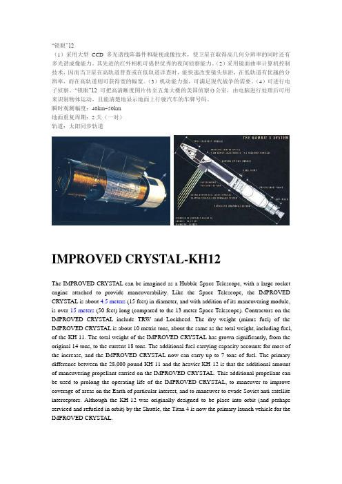
“锁眼”12(1)采用大型CCD多光谱线阵器件和凝视成像技术,使卫星在取得高几何分辨率的同时还有多光谱成像能力。
其先进的红外相机可提供优秀的夜间侦察能力。
(2)采用镜面曲率计算机控制技术,因而当卫星在高轨道普查或在低轨道详查时,能快速改变镜头焦距,在低轨道有优越的分辨率,而在高轨道则可获得宽的幅宽。
(3)机动能力强,可满足现代战争的需要。
(4)可进行电子侦察。
“锁眼”12可把高清晰度图片传至五角大楼的美国侦察办公室,由电脑进行处理后可用来识别物体运动,且能清楚地显示地面上行驶汽车的车牌号码。
瞬时观测幅度:40km~50km地面重复周期:2天(一对)轨道:太阳同步轨道IMPROVED CRYSTAL-KH12The IMPROVED CRYSTAL can be imagined as a Hubble Space Telescope, with a large rocket engine attached to provide maneuverability. Like the Space Telescope, the IMPROVED CRYSTAL is about 4.5 meters (15 feet) in diameter, and with addition of its maneuvering module, is over 15 meters (50 feet) long (compared to the 13 meter Space Telescope). Contractors on the IMPROVED CRYSTAL include TRW and Lockheed. The dry weight (minus fuel) of the IMPROVED CRYSTAL is about 10 metric tons, about the same as the total weight, including fuel, of the KH-11. The total weight of the IMPROVED CRYSTAL has grown significantly, from the original 14 tons, to the current 18 tons. The additional fuel-carrying capacity accounts for most of the increase, and the IMPROVED CRYSTAL now can carry up to 7 tons of fuel. The primary difference between the 28,000 pound KH-11 and the heavier KH-12 is that the additional amount of maneuvering propellant carried on the IMPROVED CRYSTAL. This additional propellant can be used to prolong the operating life of the IMPROVED CRYSTAL, to maneuver to improve coverage of areas on the Earth of particular interest, and to maneuver to evade Soviet anti-satellite interceptors. Although the KH-12 was originally designed to be place into orbit (and perhaps serviced and refueled in orbit) by the Shuttle, the Titan 4 is now the primary launch vehicle for the IMPROVED CRYSTAL.The optical sensors on the IMPROVED CRYSTAL are similar to the those of theKH-11. These electronic cameras provide real-time transmission of images to ground stations via Milstar relay satellites. The IMPROVED CRYSTAL sensors operate in visible and near infrared light, as well as thermal infrared to detect heat sources. These sensors probably incorporate low-light-level image intensifiers to provide night-time images. The KH-12's have an infrared capability superior to that of the IMPROVED CRYSTAL, with the advantage in infrared primarily for camouflage detection, for looking at buried structures, for looking at differential thermal inertia in the target area, for trying to determine which factories are operating and which factories are not.The IMPROVED CRYSTAL's sophisticated electronics provides sharper images than the KH-11, comparable in quality to the best of the film return satellites, with a resolution approaching ten centimeters. A periscope-like rotating mirror reflects images onto the primary mirror, enabling the KH-12 to take pictures at very high angles of obliquity, imaging objects hundreds of kilometers away from its flight path.Assembling the International Space Station [ISS] requires cooperation among the United States and its four international partners during 44 Space Shuttle flights commencing in late 1998. A Russian Service Module is required to support the ISS's initial assembly process and on-orbit development. Continued delays in Russian funding of the RSM, required for the third assembly phase of the ISS, raised considerable concern throughout the ISS community. NASA funded feasibility studies to provide alternate solutions and these studies identified a relatively low-cost and low-risk approach for an Interim Control Module (ICM), referred to as the Naval Research Laboratory (NRL) Bus. This concept offers a flight-proven design, initially developed as the Bus for the IMPROVED CRYSTAL, capable of delivery within the timeframe needed to maintain ISS schedules. The ICM will provide reboost and attitude control for the ISS from assembly phase 2A-7A, and possibly 8A. The ICM is deployed from the Space Shuttle and mated with the ISS at the Russian Node (called the FGB). The ICM provides at least one year of propellant operation with a goal of three years of operation.KH-12 /1 was launched on 28 November 1992 by a Titan-4 from Vandenberg.KH-12 /2 was launched on 05 December 1995 by a Titan-4 from Vandenberg.KH-12 /3 was launched on 20 December 1996 by a Titan-4 from Vandenberg.The spacecraft's mirror is believed to be as large as or larger than that of the KH-11, believed to have a 2.3 meter diameter. It may be as large as 4 meters. As a point of comparison, the HST's mirror is 2.4 m in size. Jane's Defence Weekly indicates that the secondary mirror in theCassegrain reflecting telescope A reflecting telescope reflector is an optical telescope which uses mirrors, rather than lenses, to reflect light. The British scientist Sir Isaac Newton designed the first reflector circa 1670. He designed the reflector in order to solve the problem of c system can be moved significantly, allowing images to be taken from angles unusual for a satellite. Also, there are indications that the satellite can take images every 5 second This article is about the unit of time. See second (disambiguation) for other uses The second (symbol s is a unit for time, and one of seven SI base units. It is defined as the duration of 9,192,631,770 periods of the radiation corresponding to the transis. Sources vary on how the KH-12 communicates with ground stations. Several different clusters of relay satellites are available, so the birds may use the Satellite Data System The Satellite Data System SDS is a system of United States military communications satellites. At least two generations have been used: SDS-1 from July 1976 to November 1995, and SDS-2 from 1989 to the present. SDS satellites have a highly elliptical orbi (SDS), MILSTAR , or Tracking and Data Relay Satellite System (TDRSS) networks.KH-11:Then, in 1977, the fifth generation dawned with the launch of the KH-11. This was a major breakthrough, as canisters were no longer needed and resolution was such that objects 70mm (a few inches) in size could be identified from 200 kilometers up via digital photos. The KH-11 telescopic cameras operated like a high resolution TV camera. Images were captured continuously and transmitted to earth stations. Computers were used to finish the process and produce photos identical to those taken by a conventional film camera. You could even have motion pictures, as well as indications of heat and the nature of the various items. KH-11 could often tell what kind of metal an object on the ground was made of. This did not come cheap, these birds cost over $400 million each and lasted three or four years, depending on fuel usage. Moreover, you needed two of them up at the same time in order to guarantee coverage and save the birds from having to change orbit too frequently.The most recent KH-11, the 15th, was launched in 2011. There have been at least four models of the KH-11, since the first of five "Block 1s" was launched in 1976. Name KH-11Block [35] Launch date ID NROL numberOrbit Plan e [35] Orbital decay date OPS 5705 1-1 19 December 1976 1976-125A [36]N/A 247 km × 533 km, i=96.9° West 28 January 1979 OPS 4515 1–2 14 June 1978 1978-060A [37]276 km × 509 km, i=96.8° West 23 August 1981 OPS 2581 1–3 7 February 1980 1980-010A [38]309 km × 501 km, i=97.1° East 30 October 1982 OPS 3984 1–4 3 September 1981 1981-085A [39]244 km × 526 km, i=96.9° West 23 November 1984 OPS 9627 1–5 17 November 1982 1982-111A [40]280 km × 522 km, i=96.9° East 13 August 1985 USA-6 2-1 4 December 1984 1984-122A [41] 335 km × 758 km, i=98°[26] West 10 November 1994 Unknown 2-2 28 August 1985 N/AFailed to orbit East N/A USA-27 2–3 26 October 1987 1987-090A [42] 300 km × 1000 km, i=98°[26] East 11 June 1992 USA-33 2–4 6 November 1988 1988-099A [43] 300 km × 1000 km, i=98°[26] West 12 May 1996 USA-86 3-1 28 November 1992 1992-083A [44] 408 km × 931 km, i=97.7°[45] East 5 June 2000 USA-116 3-2 5 December 1995 1995-066A [46] 405 km × 834 km, i=97.7°[47] East 19 November 2008 USA-129 3-3 20 December 1996 1996-072A [48] NROL-2 292 km × 894 km, i=97.7°[49] West USA-161 4-1 5 October 2001 2001-044A [50] NROL-14 309 km × 965 km, i=97.9°[51] East USA-186 3–4 19 October 2005 2005-042A [52] NROL-20 256 km × 1006 km, i=97.9°[53] West USA-224 4-2 20 January 2011 2011-002A [54]NROL-49 290 km × 985 km, Easti=97.9°[55]The KH-11 KENNAN (KENNEN according to other sources[1][2][3]), renamed CRYSTAL in 1982[4]and also referenced by the codenames 1010,[5] and "Key Hole"[5]), is a type of reconnaissance satellite launched by the American National Reconnaissance Office since December 1976. Manufactured by Lockheed in Sunnyvale, California, the KH-11 was the first American spy satellite to utilize electro-optical digital imaging, and create a real-time optical observation capability.[6]Later KH-11 satellites have been referred to by outside observers as KH-11B or KH-12, and by the names "Advanced KENNAN", "Improved Crystal" and "Ikon". The Key Hole series was officially discontinued in favour of a random numbering scheme after repeated public references to KH-8 Gambit, KH-9 Hexagon, and KH-11 satellites.[7] KH-11 satellites are believed to have been the source of some imagery of the Soviet Union and China made public in 1997, as well as images of Sudan and Afghanistan made public in 1998 that were related to the response to the 1998 U.S. embassy bombings.Program history and logisticsThe Film Read-Out GAMBIT (FROG) served as NRO Program A's competitor to NRO Program B's initial electro-optical imagery (EOI) satellite.[8]Data is transmitted through a network of communications satellites; the Satellite Data System.[4] The initial ground station for the processing of the electro-optical imaging was a secret National Reconnaissance Office facility in Area 58, located in the continental United States according to the NRO,[9]and more precisely in Fort Belvoir according to other sources.[10]In 1999, NRO selected Boeing as the prime contractor for the Future Imagery Architecture (FIA) program, aimed at replacing the KH-11 satellites by a more cost effective constellation of smaller, and also more capable reconnaissance satellites. After the failure of the FIA in 2005, NRO ordered from Lockheed two additional legacy hardware KH-11s.[11]USA-224, the first of these two, was launched in early 2011 two years ahead of the initial schedule estimate.[12]In January 2011 NRO offered NASA two space optical systems with 2.4 m diameter primary mirrors, similar to the Hubble Space Telescope, yet with steerable secondary mirrors and shorter focal length resulting a wider field of view. These could either be spare hardware from the KH-11 program, or optics from the cancelled FIA program.[13][14]The satellites were reportedly stored in a clean room facility at ITT Exelis in Rochester, NY.[15][16]DesignIt is believed to resemble the Hubble Space Telescope in size and shape, as the satellites were shipped in similar containers. Furthermore, a NASA history of the Hubble,[17]in discussing the reasons for switching from a 3-meter main mirror to a 2.4-meter design, states: "In addition, changing to a 2.4-meter mirror would lessen fabrication costs by using manufacturing technologies developed for military spy satellites." A CIA history states that the primary mirror on the first KH-11s measured 2.34 meters, but sizes increased in later versions.[4]NRO led the development of a computer controlled mirror polishing technique, which was subsequently also used for the polishing of the primary mirror of the Hubble Space Telescope.[18]Assuming a 2.4-meter mirror, the theoretical ground resolution with no atmospheric degradation and 50% MTF would be roughly 15 cm (6 inches). Operational resolution would be worse due to effects of the atmosphere. Different versions of the KH-11 vary in mass, with earlier blocks ranging from 13,000 to 13,500 kilograms, whilst later blocks have a mass of around 19,600 kg. Its length is believed to be 19.5 meters, and diameter is 3 meters or less.[4][19]The two optical telescope assemblies (OTAs only, not full satellites) offered to NASA from the NRO in January 2011 are suspected, but not confirmed, to be KH-11 series "extra hardware." The OTA's are of a three-mirror anastigmat(TMA) optical design (sans the 3rd "tertiary" mirror). The f/1.2 primary has a diameter of 2.4 m, and is refocused by the secondary to give an overall f/8 focal ratio, making the optical telescope assembly shorter than that of HST. With the addition of the tertiary mirror, this will produce a much wider field than Hubble's 2-mirror f/24 Ritchey–Chrétien optical design, making it an potential ideal observatory for Dark Energy or other astrophysics surveys. The secondary mirror is mounted on a hexapod to increase the side-viewing and ground scanning ability for the originally intended reconnaissance mission.[15][16][20]KH-11 was the first reconnaissance satellite equipped with charge-coupled device (CCD) array technology for imaging which had a resolution of 800 x 800 pixels.[21] Later block satellites may include signals intelligence capabilities and greater sensitivity in broader light spectrums (probably into infrared).[22]Later satellites had larger mirrors, with a diameter of around 2.9–3.1 m.[23] Jane's Defence Weekly indicates that the secondary mirror in the Cassegrain reflecting telescope system could be moved, allowing images to be taken from angles unusual for a satellite. Also, there are indications that the satellite can take images every five seconds.Four generations of U.S. electro-optical reconnaissance have been identified:[24][25]Block IBlock I refers to the original KH-11 satellite, of which five were launched between 19 December 1976 and 17 November 1982.Block IIThe three Block II satellites are in the open literature referred to as KH-11B, the alleged DRAGON codename, or Crystal, and are believed to be capable of taking infrared images in addition to optical observations.[26]The first or second Block II satellite was lost in a launch failure.[25]Block IIIFour Block III satellites, commonly called KH-12 or Improved Crystal were launched between November 1992 and October 2001. The name "Improved Crystal" refers to the "Improved Metric CRYSTAL System" (IMCS), which adds reference markings for accurate mapping to images obtained by the satellite.[27]Block IVTwo electro-optical satellites launched in October 2005 and January 2011 are attributed to Block IV.DerivativesThe Misty satellite is believed to have been derived from the KH-11, but modified to make it invisible to radar, and hard to detect visually. The first Misty satellite, USA-53, was released by the Space Shuttle Atlantis on mission STS-36. The USA-144 satellite, launched on 22 May 1999 by a Titan IV B from Vandenberg Air Force Base may have been a second Misty satellite,[28]or an Enhanced Imaging System spacecraft. The satellites are sometimes identified as KH-12s.CompromiseKH-11 image of the construction of a Kiev-class aircraft carrier, as published by Jane's in 1984.In 1978, a young CIA employee named William Kampiles was accused of selling a KH-11 System Technical Manual describing design and operation to the Soviets. Kampiles was convicted of espionage and initially sentenced to 40 years in prison.[29] Later, this term was reduced, and after serving 18 years, Kampiles was released in 1996.[30][31]In 1984 Samuel Loring Morison, an intelligence analyst at the Naval Intelligence Support Center, forwarded three classified images taken by KH-11 to the publication Jane's Fighting Ships. In 1985, Morison was convicted in Federal Court on two counts of espionage and two counts of theft of government property, and was sentenced to two years in prison.[32]He was pardoned by President Clinton in 2001.[33]KH-11 missionsOrbital constellation of the KH-11 satellites currently in orbit (situation August 2011)Nine KH-11 satellites were launched between 1976 and 1990 aboard Titan-3D and −34D rockets, with one launch failure. For the following five satellite launches between 1992 and 2005, a Titan IV launch vehicle was used. The most recent launch in 2011 was carried out by a Delta IV Heavy rocket. The KH-11 replaced the KH-9 film return satellite, among others, the last of which was lost in a liftoff explosion in 1986.KH-11 satellites are in either of two standard planes in Sun-synchronous orbits. As shadows help to discern ground features, satellites in a standard plane east of a noon/midnight orbit observe the ground at local afternoon hours, while satellites in a western plane observe the ground at local morning hours.[34][35] Historically launches have therefore been timed to occur either about two hours before or one hour after local noon (or midnight), respectively.[25]Dynamical Test Unit of KH-11 (unconfirmed) Three Mirror AssemblyKH-12 最终没有发射美国空间成像公司的“伊科诺斯”卫星和法国“斯波特”卫星图像的利用率。
美国开发出微型合成孔径雷达
1 美国开发出微型合成孔径雷达(miniSAR) 2004年03月15日 08:50 电子工业科技信息中心[本刊2004年2月29日报道]美国家核安全管理局下属的圣地亚国家实验室最新设计出微型合成孔径雷达(miniSAR),并计划在年内进行飞行试验。
这款雷达将用于与模型飞机大小相当的无人机,以后还将用于精确制导武器和空间应用。
微型合成孔径雷达的重量不足13.6千克,重量是"捕食者"无人机现使用的SAR 的四分之一,而体积仅是后者的十分之一。
该雷达具有与大型SAR 许多相同的功能,可以在各种天 气下,在夜间以及沙尘暴中提供高分辨率的(0.1米)图像,唯一不同之处在于大型SAR 由于其天线长、发射机功率高,探测距离可以达到35千米,而与之相比较,微型合成孔径雷达却只有15千米的探测距离,但这一指标已完全满足小型无人机的需求了。
这项新技术中涉及到机械设计、数字小型化、RF 小型化以及导航等关键技术。
微型合成孔径雷达主要由两个子系统组成:天线万向节组件(AGA),为指向系统,包括天线、万向节和发射机,AGA 负责发送和接收电波;雷达电子组件(REA)包括信号产生器、接收机和处理器,REA 是一个电子包,负责生成雷达信号、控制系统、处理数据并将其转换成图像。
研制小组在开发成功超轻的天线,并实现万向节最小化后,AGA 的重量由原27千克降到8.2千克,通过使用最新的数字和射频技术,REA 的重量由原来的27千克降到3.6千克。
未来,在微系统等技术的推动下,微型合成孔径雷达系统重量将降至4.5千克左右。
微型合成孔径雷达主要有两个应用。
第一个应用是作为无人机(如"影子"无人机)的侦察系统。
这种小型无人机可以携带22.7千克的有效载荷,现有的雷达是无法使用的。
因此,目前的小型无人机只能携带视频和红外照相机。
未来,小型无人机在安装了13.7千克的微型合成孔径雷达外,还可安装其他传感器,共同提供一个详细的侦察图像。
气象卫星列表

Satellite StatusMaintained by WMO on behalf of CGMSThis page lists the status of current and future satellites contributing to the WMO Integrated Global Observing System (WIGOS). This information is extracted from OSCAR/Space(Observing Systems Capability Analysis and Review Tool). For further information, please go directly to the tool, which offers search, filter and export facilities and addresses a larger number of Earth observation satellites. The links in the tables also lead directly to OSCAR/Space. For more details on the satellites, e.g. payload characteristics, data access or telecommunication frequencies please click on the respective name.Core Meteorological Satellite Programmes Contributing to WIGOSSustained or R&D Satellite Programmes Contributing to WIGOSGeostationary orbitCurrent GEO Satellites Future GEO SatellitesHighly elliptical or geosynchronous orbitCurrent HEO SatellitesFuture HEO SatellitesSun-synchronousCurrent Sun-sync. SatellitesFuture Sun-sync. SatellitesLow Earth orbitCurrent LEO SatellitesFuture LEO SatellitesSpecific orbits (for space weather)Current other SatellitesFuture other SatellitesCurrent Geostationary Meteorological SatellitesSectorEastLongNameOperator(s)NOAALaunchInstrumentsDetailsInitially stored in stand-by position at 89.5°W.135 ° W GOES-152010-03-04 DCIS GEOS&RSectorPacificLongName(Operational)Operator(s)NASALaunchInstrumentsIMAGER (GOES 12-15) SEM/EPS SEM/HEPAD SEM/MAG SEM/XRS-EUV SOUNDER SXIDetailsMoved to 135°W in December 2011 to replace GOES-11 as GOES-W.West Atlantic105 ° W GOES-14 (Stand-by)NOAA NASA2009-06-27 DCIS GEOS&R IMAGER (GOES 12-15) SEM/EPS SEM/HEPAD SEM/MAG SEM/XRS-EUV SOUNDER SXIInitially stored in back-up position at 105°W From 23 Sept to 19 Oct 2012, moved at towards 75°W to back-up GOES-13, stopped at 89.5°W after GOES-13 service recovery From 19 Dec 2012 to 6 Feb 2013, moved back towards 105°W at 0.34 degrees/day. Activated as back-up for GOES-13 for a couple of weeks starting from 23 May 2013, keepingSectorLongNameOperator(s)LaunchInstrumentsDetailsthe 105°W position.75 ° WGOES-13 (Operational)NOAA NASA2006-05-24 DCIS GEOS&R IMAGER (GOES 12-15) SEM/EPS SEM/HEPAD SEM/MAG SEM/XRS-EUV SOUNDER SXISXI and the XRS are operational with limitations. Anomaly occurred on 22 May 2013; back to operations after a few weeks. Continuity was provided by GOES-14 from 105°W.East Atlantic0°Meteosat-10 (Operational)EUMETSAT ESA2012-07-05 DCS (Meteosat) GEOS&R GERB SEVIRIInitially placed at 3.4°, it has replaced Meteosat-9 at 0° as of 21 January 2013. GERB not functional. Data disseminated by EUMETCast and LRIT3.5 ° EMeteosat-8 (Stand-by)EUMETSAT ESA2002-08-28 DCS (Meteosat) GEOS&R GERB SEVIRIHRIT and LRIT transponders failed shortly after launch, data disseminated by EUMETCast. In April 2007, moved toSectorLongNameOperator(s)LaunchInstrumentsDetails9.5°E for Rapid Scan Service (RSS) of the European sector at 5 min intervals; RSS became operational on 13 May 2008. GERB is in safe mode. DCS is switched-off. GEOS&R is switched-off.9.5 ° EMeteosat-9 (Operational)EUMETSAT ESA2005-12-21 DCS (Meteosat) GEOS&R GERB SEVIRIPrimary operational satellite at 0° as of 11 April 2007. Replaced by Meteosat-10 as of 21 January 2013. RSS service taken over from Meteosat-8 in April 2013. Prime GERB service. HRIT not activated. High Rate Information is disseminated in near-real-time by EUMETCast. DCS is switched-off.Indian Ocean57.5 ° E Meteosat-7 (IODC) (Operational)EUMETSAT ESA2006-12-05 DCS (Meteosat) MVIRIRe-location of Meteosat-7 over the Indian Ocean. The launch date should beSectorLongNameOperator(s)LaunchInstrumentsDetailsunderstood as the start of the IODC service. Dissemination via EUMETCast. WEFAX used only for internal purposes.74 ° EINSAT-3C (Operational)ISRO2002-01-2474 ° EKalpana-1 (Operational)ISRO IMD2002-09-12 DCS (INSAT) VHRR (INSAT)The Data Collection System is currently not being used due to excessive orbit inclination (3.8°).76 ° EElectro-L N1 (Warning)RosHydroMet Roscosmos2011-01-20 DCS (Electro) GEOS&R (Electro) GGAK-E/DIR-E GGAK-E/FM-E GGAK-E/GALS-E GGAK-E/ISP-2M GGAK-E/SKIF-6 GGAK-E/SKL-E GGAK-E/VUSS-EMSU-GS: calibration issues and excessive noise in some IR channels. Water vapour channel not functional. GGAK operates with significant limitations. Due to technical issues onboard, MSU-GS instrument isSectorLongNameOperator(s)LaunchInstrumentsMSU-GSDetailscurrently (May 2014) disabled.82 ° EINSAT-3D (Operational)ISRO2013-07-25 DCS (INSAT) IMAGER (INSAT) SAS&R SOUNDER (INSAT)86.5 ° E FY-2D (Operational)CMA NRSCC2006-12-08 DCS (FY) S-VISSR (FY-2C/D/E) SEM (FY 2&4)Secondary operational position Scanning schedules of the primary and secondary spacecraft are interleaved,86.5 ° E FY-2G (Commissioning)CMA NRSCC2014-12-30 DCS (FY) S-VISSR (FY-2F/G/H) SEM (FY 2&4) SXM93.5 ° E INSAT-3A (Operational)ISRO2003-04-10 CCD DCS (INSAT) SAS&R VHRR (INSAT)105 ° EFY-2ECMA NRSCC2008-12-23 DCS (FY) S-VISSRPrimary operational position.SectorLongName(Operational)Operator(s)LaunchInstruments(FY-2C/D/E) SEM (FY 2&4)DetailsScanning schedules of the primary and secondary spacecraft are interleavedWest Pacific112.5 ° EFY-2F (Stand-by)CMA NRSCC2012-01-13 DCS (FY) S-VISSR (FY-2F/G/H) SEM (FY 2&4) SXMUsed for regional scanning.128.2 ° ECOMS-1 (Operational)KMA KARI ME MLTM2010-06-26 GOCI MI140 ° EHimawari-6 (MTSAT-1R) (Operational)JMA JCAB2005-02-26 DCS (Himawari) JAMIImagery mission taken up by MTSAT-2 on 1st July 2010. Provision of HRIT and LRIT service for MTSAT-2 data. Provision of DCP service Imagery of the Japanese area at 5-min intervals in daylight since 2011. Imagery of the AustralianSectorLongNameOperator(s)LaunchInstrumentsDetailscontinent in January-March 2014 at 10-min intervals to support an international field campaign in Darwin.140 ° EHimawari-8 (Commissioning)JMA2014-10-07 AHI DCS (Himawari) SEDACommissioning will last until mid-2015.145 ° EHimawari-7 (MTSAT-2) (Operational)JMA JCAB2006-02-18 DCS (Himawari) IMAGER (MTSAT-2)Primary operational spacecraft replacing MTSAT-1R as of 1st July 2010. Data dissemination performed by MTSAT-1R. DCP mission performed by MTSAT-1R.Future Geostationary Meteorological SatellitesSector Long Name Operator(s) Launch Instruments DetailsSectorEast PacificLongNameOperator(s)NOAA NASALaunch≥2016InstrumentsABI DCIS EXIS GEOS&R GLM SEISS/EHIS SEISS/MPS SEISS/SGPS SEM/MAG SUVIDetailsLongitude (137°W or 75°W) to be confirmed in due time.137 ° W GOES-R (Planned)137 ° W GOES-T (Planned)NOAA NASA≥2019ABI DCIS EXIS GEOS&R GLM SEISS/EHIS SEISS/MPS SEISS/SGPS SEM/MAG SUVI time.Longitude (137°W or 75°W) to be confirmed in dueWest75 ° WGOES-SNOAA≥2017ABILongitude (137°W orSectorAtlanticLongNameOperator(s)NASALaunchInstrumentsDCIS EXIS GEOS&R GLM SEISS/EHIS SEISS/MPS SEISS/SGPS SEM/MAG SUVIDetails75°W) to be confirmed in due time.(Planned)75 ° WGOES-U (Planned)NOAA NASA≥2025ABI DCIS EXIS GEOS&R GLM SEISS/EHIS SEISS/MPS SEISS/SGPS SEM/MAG SUVI time.Longitude (137°W or 75°W) to be confirmed in dueEast Atlantic14.5 ° WElectro-L N3 (Planned)RosHydroMet Roscosmos≥2015DCS (Electro) GEOS&R (Electro) GGAK-E/DIR-EGEO position TBD between 14.5°W and 166°ESectorLongNameOperator(s)LaunchInstrumentsGGAK-E/FM-E GGAK-E/GALS-E GGAK-E/ISP-2M GGAK-E/SKIF-6 GGAK-E/SKL-E GGAK-E/VUSS-E MSU-GSDetails14.5 ° WElectro-M N2-1 (Considered)RosHydroMet Roscosmos≥2023DCS (Electro) ERBR GEOS&R (Electro) GGAK-E/DIR-E GGAK-E/FM-E GGAK-E/GALS-E GGAK-E/ISP-2M GGAK-E/SKIF-6 GGAK-E/SKL-E GGAK-E/VUSS-E IRFS-GS LM MSU-GSMGEO position TBD between 14.5°W and 166°E0°MTG-S1EUMETSAT EC≥2021DCS (Meteosat) GEOS&RSectorLongName(Planned)Operator(s)ESALaunchInstrumentsIRS Sentinel-4Details0°MTG-S2 (Planned)EUMETSAT EC ESA≥2029DCS (Meteosat) GEOS&R IRS Sentinel-40°Meteosat-11 (Planned)EUMETSAT ESA≥2015DCS (Meteosat) GEOS&R GERB SEVIRI0TBDElectro-M N3-1 (Considered)RosHydroMet Roscosmos≥2025DCS (Electro) ERBR GEOS&R (Electro) GGAK-E/DIR-E GGAK-E/FM-E GGAK-E/GALS-E GGAK-E/ISP-2M GGAK-E/SKIF-6 GGAK-E/SKL-E GGAK-E/VUSS-E IRFS-GS LMSectorLongNameOperator(s)LaunchInstrumentsMSU-GSMDetailsTBDElectro-M N3-2 (Considered)RosHydroMet Roscosmos≥2025DCS (Electro) ERBR GEOS&R (Electro) GGAK-E/DIR-E GGAK-E/FM-E GGAK-E/GALS-E GGAK-E/ISP-2M GGAK-E/SKIF-6 GGAK-E/SKL-E GGAK-E/VUSS-E IRFS-GS LM MSU-GSM9.5 ° EMTG-I1 (Planned)EUMETSAT EC ESA≥2019DCS (Meteosat) FCI GEOS&R LI9.5 ° EMTG-I2 (Planned)EUMETSAT EC ESA≥2023DCS (Meteosat) FCI GEOS&R LISectorLong9.5 ° ENameMTG-I3 (Planned)Operator(s)EUMETSAT EC ESALaunch≥2027InstrumentsDCS (Meteosat) FCI GEOS&R LIDetails9.5 ° EMTG-I4 (Planned)EUMETSAT EC ESA≥2031DCS (Meteosat) FCI GEOS&R LIIndian Ocean74 ° EINSAT-3DR (Planned)ISRO≥2015DCS (INSAT) IMAGER (INSAT) SAS&R SOUNDER (INSAT)74 ° EINSAT-3DS (Planned)ISRO≥2022DCS (INSAT) IMAGER (INSAT) SAS&R SOUNDER (INSAT)76 ° EElectro-M N1-1 (Considered)RosHydroMet Roscosmos≥2021DCS (Electro) ERBR GEOS&R (Electro) GGAK-E/DIR-E GGAK-E/FM-E GGAK-E/GALS-ESectorLongNameOperator(s)LaunchInstrumentsGGAK-E/ISP-2M GGAK-E/SKIF-6 GGAK-E/SKL-E GGAK-E/VUSS-E IRFS-GS LM MSU-GSMDetails76 ° EElectro-M N1-2 (Considered)RosHydroMet Roscosmos≥2022DCS (Electro) ERBR GEOS&R (Electro) GGAK-E/DIR-E GGAK-E/FM-E GGAK-E/GALS-E GGAK-E/ISP-2M GGAK-E/SKIF-6 GGAK-E/SKL-E GGAK-E/VUSS-E IRFS-GS LM MSU-GSM77.8 ° E Electro-L N2RosHydroMet Roscosmos≥2015DCS (Electro) GEOS&R (Electro)Launch scheduled for 9 April 2015.SectorLongName(Planned)Operator(s)LaunchInstrumentsGGAK-E/DIR-E GGAK-E/FM-E GGAK-E/GALS-E GGAK-E/ISP-2M GGAK-E/SKIF-6 GGAK-E/SKL-E GGAK-E/VUSS-E MSU-GSDetails86.5 ° E FY-2H (Planned)CMA NRSCC≥2016DCS (FY) S-VISSR (FY-2F/G/H) SEM (FY 2&4) SXM86.5 ° E FY-4A (Planned)CMA NRSCC≥2016AGRI DCS (FY) GIIRS LMI SEMIP86.5 ° E FY-4C (Planned)CMA NRSCC≥2020AGRI DCS (FY) GIIRS LMISectorLongNameOperator(s)LaunchInstrumentsSEMIP SXEUVDetails86.5 ° E FY-4E (Planned)CMA NRSCC≥2027AGRI DCS (FY) GIIRS LMI SEMIP SXEUV86.5 ° E FY-4G (Planned)CMA NRSCC≥2033AGRI DCS (FY) GIIRS LMI SEMIP SXEUV105 ° EFY-4B (Planned)CMA NRSCC≥2018AGRI DCS (FY) GIIRS LMI SEMIP SXEUV105 ° EFY-4DCMA NRSCC≥2023AGRI DCS (FY)SectorLongName(Planned)Operator(s)LaunchInstrumentsGIIRS LMI SEMIP SXEUVDetails105 ° EFY-4F (Planned)CMA NRSCC≥2030AGRI DCS (FY) GIIRS LMI SEMIP SXEUVWest Pacific128 ° EGEO-KOMPSAT-2B KMA KARI (Planned) ME MLTM≥2018GEMS GOCI-II128.2 ° EGEO-KOMPSAT-2A KMA KARI (Planned) ME MLTM≥2018AMI KSEM/MAG KSEM/MEPD KSEM/SCM140 ° EHimawari-9 (Planned)JMA≥2016AHI DCS (Himawari) SEDASectorLong166 ° ENameElectro-L N4 (Planned)Operator(s)RosHydroMet RoscosmosLaunch≥2017InstrumentsDCS (Electro) GEOS&R (Electro) GGAK-E/DIR-E GGAK-E/FM-E GGAK-E/GALS-E GGAK-E/ISP-2M GGAK-E/SKIF-6 GGAK-E/SKL-E GGAK-E/VUSS-E MSU-GSDetailsGEO position TBD between 14.5°W and 166°E166 ° EElectro-M N2-2 (Considered)RosHydroMet Roscosmos≥2024DCS (Electro) ERBR GEOS&R (Electro) GGAK-E/DIR-E GGAK-E/FM-E GGAK-E/GALS-E GGAK-E/ISP-2M GGAK-E/SKIF-6 GGAK-E/SKL-E GGAK-E/VUSS-E IRFS-GS LM MSU-GSMGEO position TBD between 14.5°W and 166°ECurrent Sun-synchronous Meteorological SatellitesSectorECT Altitude NameOperator(s)Launch InstrumentsDetails05:22 desc850 km DMSP-F16(Operational)DoD NOAA2003-10-18OLSSESS/SSI/ES-2 SESS/SSJ5 SESS/SSM SESS/SSULI SESS/SSUSI SSMIS05:30 desc850 km DMSP-F19(Operational)DoD NOAA2014-04-03OLSSESS/SSI/ES-2 SESS/SSJ5 SESS/SSM SESS/SSULI SESS/SSUSI SSMISEarly Morning Orbit05:49 850 km DMSP-F17 DoD 2006-11-04OLSSectorECTAltitudeName Operator(s)Launch InstrumentsDetailsdesc(Operational)NOAASESS/SSI/ES-2 SESS/SSJ5 SESS/SSM SESS/SSULI SESS/SSUSI SSMIS05:51 desc850 km DMSP-F13(Warning)DoD NOAA1995-03-24OLSSEM (DMSP) SSM/I SSM/TTape recorder failed19th Nov 2009, thus no global data.08:06 desc850 km DMSP-F18(Operational)DoD NOAA2009-10-18OLSSESS/SSI/ES-2 SESS/SSJ5 SESS/SSM SESS/SSULI SESS/SSUSI SSMISMorning Orbit09:30 desc836 km Meteor-M N2(Operational)RosHydroMet Roscosmos2014-07-08GGAK-M/KGI-4CGGAK-M/MSGI-MKA IKFS-2Sector ECT Altitude Name Operator(s) Launch Instruments DetailsKMSSMSU-MRMTVZA-GYSSPDSeverjanin-M09:30desc827 km Metop-A(Operational)EUMETSATESA2006-10-19A-DCSAMSU-AASCATAVHRR/3GOME-2GRASHIRS/4IASIMHSS&RSATSEM/MEPEDSEM/TEDLRPT failed soon afterlaunch, one AHRPTtransmitter failed 6 monthslater.Global datadisseminated by EUMETCastbecame the primarydissemination system.As of Sept 2008 theredundant AHRPT unit isutilised for a partial coverage,enabling the reception andretransmission of NRT databy EARS.Since June 2011 thelatency of global data isreduced by the use of theSector ECT Altitude Name Operator(s) Launch Instruments DetailsAntarctic Data Acquisitionstation (ADA) at McMurdo.The AMSU-A channel50.3 and 54.95 GHz areexperiencing increasingnoise, and have exceeded thethreshold in September 2013.MHS exhibits someproblem since 26 March2014.09:30desc827 km Metop-B(Operational)EUMETSATESA2012-09-17A-DCSAMSU-AASCATAVHRR/3GOME-2GRASHIRS/4IASIMHSS&RSATSEM/MEPEDSEM/TEDReplacing MetOp-Afor operations in April 2013.Dissemination viaEUMETCast.HIRS/4 channels13.97, 13.64 and 12.47 μmout of specs since August2013.Sector ECT Altitude Name Operator(s) Launch Instruments Details10:00desc836 km FY-3C(Operational)CMANRSCC2013-09-23ERM-1GNOSIRASMERSI-1MWHS-2MWRIMWTS-2SBUSSES/IPMSES/SEMSES/WAISIM-2TOUVIRR (FY-3)10:15desc836 km FY-3A(Warning) CMANRSCC2008-05-27ERM-1IRASMERSI-1MWHS-1MWRIMWTS-1SBUSSEM (FY 1&3)SIM-1MWRI failed soonafter launch.IRAS failed in October2008.SBUS failed inDecember 2008.ERM failed in May2010.Sector ECT Altitude Name Operator(s) Launch Instruments DetailsTOUVIRR (FY-3)MWTS failed in December 2012.13:25asc834 km Suomi-NPP(Operational)NASADoDNOAA2011-10-28ATMSCERESCrISOMPS-limbOMPS-nadirVIIRSAfternoon orbit13:39asc870 km NOAA-19(Operational)NOAA2009-02-06A-DCSAMSU-AAVHRR/3HIRS/4MHSS&RSATSBUV/2SEM/MEPEDSEM/TEDA-DCS affected bysome anomaly since earlyafter launch.MHS channel 183.311± 1.0 GHz noisy sinceDecember 2009.AMSU-A channel 55.5GHz noisy since December2009.HIRS/4 has severalchannels noisy since February2013, and the filter wheelunstable since January 2014.Sector ECT Altitude Name Operator(s) Launch Instruments DetailsThe ECT, initially14:00asc, is drifting at a rateof 0.77 min/month.13:40asc836 km FY-3B(Operational)CMANRSCC2010-11-04ERM-1IRASMERSI-1MWHS-1MWRIMWTS-1SBUSSEM (FY 1&3)SIM-1TOUVIRR (FY-3)ERM failed in August2011.15:23asc852 km DMSP-F14(Warning) DoDNOAA1997-04-04OLSSEM (DMSP)SSM/ISSM/TSSM/T-2F-14 tape recorderfailed Aug 2008, thus noglobal data.SSM/I, SSM/T andSSM/T2 no longer operable.15:23 asc 854 km NOAA-18NOAA2005-05-20AMSU-AAVHRR/3HIRS/4 noisy sincelaunch, finally declaredSector ECT Altitude Name Operator(s) Launch Instruments Details(Operational)DCS/2HIRS/4MHSS&RSATSBUV/2SEM/MEPEDSEM/TED unusable on May 2009.SBUV inoperable since early 2013 because of failure of the chopper motor.The ECT, initially 13:30 asc, is drifting at a rate of 3.52 min/month.15:24asc850 km DMSP-F15(Warning) DoDNOAA1999-12-12OLSSEM (DMSP)SSM/ISSM/TSSM/T-2SSM/I 23 GHz channelunusable.SSM-T2 failed16:51asc807 km NOAA-15(Warning) NOAA1998-05-13AMSU-AAMSU-BAVHRR/3DCS/2HIRS/3S&RSATSEM/MEPEDSEM/TEDLAC failed soon afterlaunch.HIRS/3 turned off on6 June 2009.AMSU-B turned off on28 March 2011.AMSU-A and AVHRR/3not nominal.The ECT, initiallySector ECT Altitude Name Operator(s) Launch Instruments Details07:30 desc, is drifting at a rate of 1.05 min/month.Future Sun-synchronous Meteorological SatellitesSectorECTAltitudeNameOperator(s)LaunchInstrumentsDetails05:30 desc850 kmDMSP-S20(Planned)DoD NOAA≥2020OLSSESS/SSI/ES-2 SESS/SSJ5 SESS/SSM SESS/SSULI SESS/SSUSI SSMISEarly Morning Orbit06:00 desc836 km FY-3E(Planned)CMA NRSCC≥2017 ERM-2 GNOS HIRAS MERSI-2SectorECT Altitude Name Operator(s) Launch InstrumentsDetailsMWHS-2 MWTS-2 OMS-limb OMS-nadir SES/IPM SES/SEM SES/WAI SIM-2 WindRAD06:00 desc836 km FY-3G(Planned)CMA NRSCC≥2022 ERM-2 GNOS HIRAS MERSI-2 MWHS-2 MWTS-2 OMS-limb OMS-nadir SES/IPM SES/SEM SES/WAI SIM-2SectorECT Altitude Name Operator(s) Launch InstrumentsDetailsWindRAD09:30 desc817 km Metop-SG-A1(Considered)EUMETSAT ESA≥2021 3MI IASI-NG MWS MetImage RO Sentinel-509:30 desc817 km Metop-SG-A2(Considered)EUMETSAT ESA≥2028 3MI IASI-NG MWS MetImage RO Sentinel-5Morning Orbit 09:30 desc817 km Metop-SG-A3(Considered)EUMETSAT ESA≥2035 3MI IASI-NG MWS MetImage ROSectorECT Altitude Name Operator(s) Launch InstrumentsDetailsSentinel-509:30 desc817 km Metop-SG-B1(Considered)EUMETSAT ESA≥2022 A-DCS ICIMWI (MetOp-SG) ROSCA (Scatterometer)09:30 desc817 km Metop-SG-B2(Considered)EUMETSAT ESA≥2030 A-DCS ICIMWI (MetOp-SG) ROSCA (Scatterometer)09:30 desc817 km Metop-SG-B3(Considered)EUMETSAT ESA≥2036 A-DCS ICIMWI (MetOp-SG) ROSCA (Scatterometer)SectorECTAltitudeName Operator(s) LaunchInstrumentsDetails09:30 desc830 kmMeteor-MP N2(Considered)RosHydroMet Roscosmos≥2022ACS-limb ACS-nadir ARMA-MP BRLK “Briz” GGAK-M/KGI-4C GGAK-M/MSGI-MKA GORIZONT-MP IKFS-3 MSU-MR-MP MTVZA-GY-MP SSPD09:30 desc817 km Metop-C(Planned)EUMETSAT ESA≥2018 A-DCS AMSU-A ASCAT AVHRR/3 GOME-2 GRAS IASI MHSSectorECTAltitudeNameOperator(s)LaunchInstrumentsDetails09:30 desc820 kmMeteor-M N2-2(Planned)RosHydroMet Roscosmos≥2016GGAK-M/KGI-4C GGAK-M/MSGI-MKA IKFS-2 KMSS MSU-MR MTVZA-GY SSPD Severjanin-M09:30 desc820 km Meteor-M N2-4(Planned)RosHydroMet Roscosmos≥2018 GGAK-M/KGI-4C GGAK-M/MSGI-MKA IKFS-2 KMSS MSU-MR MTVZA-GY SSPD Severjanin-M12:00 desc835 km Meteor-M N3(Planned)RosHydroMet Roscosmos≥2018 OCS RadiometSAR-X (Meteor-M N3)SCAT (Meteor-M N3)SectorECT Altitude Name Operator(s) Launch InstrumentsDetailsSZS12:00 desc835 km Meteor-MP N3(Considered)RosHydroMet Roscosmos≥2023 OCSSAR-X (Meteor-M N3)SCAT (Meteor-M N3)SSPD SZS13:30 asc 824 km JPSS-1(Planned)NOAA NASA≥2017 ATMS CERES-FO CrIS OMPS-nadir SEM-N/EPS SEM-N/HES SEM-N/SSJ5 VIIRSAfternoon orbit 13:30 asc 824 km JPSS-2(Planned)NOAA NASA≥2022 ATMS CERES-FO CrIS OMPS-limbSectorECT Altitude Name Operator(s) Launch InstrumentsDetailsOMPS-nadir SEM-N/EPS SEM-N/HES SEM-N/SSJ5 VIIRS14:00 asc 836 km FY-3D(Planned)CMA NRSCC≥2015 GAS GNOS HIRAS MERSI-2 MWHS-2 MWRI MWTS-2 SES/IPM SES/SEM SES/WAI14:00 asc 836 km FY-3F(Planned)CMA NRSCC≥2019 GAS GNOS HIRAS MERSI-2 MWHS-2SectorECT Altitude Name Operator(s) Launch InstrumentsDetailsMWRI MWTS-2 SES/IPM SES/SEM SES/WAI15:30 asc 830 km Meteor-MP N1(Considered)RosHydroMet Roscosmos≥2021 ACS-limb ACS-nadir ARMA-MP BRLK “Briz” GGAK-M/KGI-4C GGAK-M/MSGI-MKA GORIZONT-MP IKFS-3 MSU-MR-MP MTVZA-GY-MP SSPD15:30 asc 820 km Meteor-M N2-1RosHydroMet Roscosmos≥2015 GGAK-M/KGI-4C GGAK-M/MSGI-MKA IKFS-2 KMSSSectorECT Altitude NameOperator(s) Launch InstrumentsDetails(Planned)MSU-MR MTVZA-GY SSPD Severjanin-M15:30 desc820 km Meteor-M N2-3(Planned)RosHydroMet Roscosmos≥2017 GGAK-M/KGI-4C GGAK-M/MSGI-MKA IKFS-2 KMSS MSU-MR MTVZA-GY SSPD Severjanin-M15:30 desc820 km Meteor-M N2-5(Planned)RosHydroMet Roscosmos≥2019 GGAK-M/KGI-4C GGAK-M/MSGI-MKA IKFS-2 KMSS MSU-MR MTVZA-GY SSPDSectorECT Altitude Name Operator(s) Launch InstrumentsDetailsSeverjanin-MCurrent Highly Elliptical Orbit or Geosynchronous SatellitesNameOperator(s)OrbitInclLaunchInstrumentsDetailsFuture Highly Elliptical Orbit or Geosynchronous SatellitesNameOperator(s)OrbitInclLaunchInstrumentsDetailsArctica-M N1(Planned)RosHydroMet RoscosmosMolniya63.4°≥2015DCS/AGGAK-E/DIR-E GGAK-E/FM-E GGAK-E/GALS-E GGAK-E/ISP-2MNameOperator(s) Orbit Incl Launch InstrumentsDetailsGGAK-E/SKIF-6 GGAK-E/SKL-E GGAK-E/VUSS-E MSU-GS/AArctica-M N2(Planned)RosHydroMet RoscosmosMolniya 63.4° ≥2016 DCS/AGGAK-E/DIR-E GGAK-E/FM-E GGAK-E/GALS-E GGAK-E/ISP-2M GGAK-E/SKIF-6 GGAK-E/SKL-E GGAK-E/VUSS-E MSU-GS/ACurrent Other LEO Satellites Contributing to WIGOSNameOperator(s)ECT / Incl.35°LaunchInstrumentsDetailsTRMM (Warning)NASA JAXA1997-11-27 CERES LIS PR TMI VIRSCERES failed 9 months after launch. In August 2001 the orbit was moved from the original 350 km to 402 km to extend lifetime and instrument swath. VIRS functional but turned off to preserve battery.EOS-Terra (Operational)NASA10:30 desc1999-12-18 ASTER CERES MISR MODIS MOPITTASTER short-wave channels not funtional since 2008.NMP-EO-1 (Operational)NASA USGS09:45 desc2000-11-21 ALI Hyperion LACLAC failed soon after launch. Operations extended beyond the originally envisaged lifetime to support design and preparation of the Landsat Data Continuity Mission.PROBA-1 (Operational)ESA07:30 desc2001-10-22 CHRIS SREMThe orbit is drifting from the original 10:30 desc ECT.NameOperator(s)ECT / Incl.89°LaunchInstrumentsDetailsGRACE (2 sats) (Operational)NASA DLR2002-03-17 BlackJack (GRACE) HAIRS LRR (DLR) SCA (GRACE) SuperSTARThe orbital height, initially 485 km, slowly decreases due to atmospheric drag.EOS-Aqua (Warning)NASA13:30 asc2002-05-04 AIRS AMSR-E AMSU-A CERES HSB MODISHSB instrument ceased operation on 5 February 2003. AMSR-E antenna stopped rotating on 4 October 2011. Used with reduced rotation rate for cross-calibration with AMSR-2. AMSU-A channels 52.8, 53.596± 0.115 and 54.94 GHz not functional.SPOT-5 (Operational)CNES10:30 desc2002-05-04 DORIS HRG HRS VégétationCoriolis (Warning)DoD NASA06:00 desc2003-01-06 SMEI WindSatSMEI turned off on 28 September 2011 because of electrical power limitations.NameOperator(s)ECT / Incl.40°LaunchInstrumentsDetailsSORCE (Operational)NASA2003-01-25 SIM SOLSTICE TIM XPSBattery degraded. Instruments turned off during orbit night. Data retrieved for up to 4 orbits/day only.ResourceSat-1 (IRS-P6) (Operational) EOS-Aura (Operational)ISRO10:30 desc2003-10-17 AWiFS LISS-3 (ResourceSat) LISS-4NASA13:45 asc2004-07-15 HIRDLS MLS (EOS-Aura) OMI TES-limb TES-nadirHIRDLS had reduced capability soon after launch, then failure of the azimuth scanning mechanism, and in practice is no longer used. TES has reduced scanning capability (no global survey).CartoSat-1 (IRS-P5) (Operational) CALIPSOISRO10:30 desc2005-05-05 PAN (CartoSat-1)NASA13:302006-04-28 CALIOPNameOperator(s)ECT / Incl.ascLaunchInstrumentsDetailsCNES (Operational) CloudSat (Operational) KOMPSAT-2 (Operational) CartoSat-2 (Operational) HY-1B (Operational) C/NOFS (Warning) DoD NASA UCAR USAF NSOAS CAST ISRO KARI NASAIIR WFC13:30 asc2006-04-28 CPR (CloudSat)Battery degraded since April 2011. Instrument turned off during orbit night.10:50 asc2006-07-28 MSC09:30 desc2007-01-10 PAN (CartoSat-2A/B)10:30 desc2007-04-11 COCTS CZI13°2008-04-16 CERTO CINDI CORISS DIDM PLPNameOperator(s)ECT / Incl.LaunchInstrumentsDetailsVEFI CartoSat-2A (Operational) JASON-2 (Operational) NASA CNES EUMETSAT NOAA 66° 2008-06-20 AMR DORIS LRA (NASA) Poseidon-3 TRSR HJ-1A (Operational) HJ-1B (Operational) GOSAT (Operational) OceanSat-2 ISRO 12:00 2009-09-23 OCM (OceanSat-2) Scatterometer (OSCAT) not functional JAXA MOE 13:00 desc 2009-01-23 TANSO-CAI TANSO-FTS CAST CRESDA 10:00 desc 2008-09-06 IRMSS (HJ-1B) WVC CAST CRESDA 10:00 desc 2008-09-06 HSI WVC ISRO 09:30 desc 2008-04-28 PAN (CartoSat-2A/B)NameOperator(s)ECT / Incl.descLaunchInstrumentsDetailsOSCAT ROSA (OceanSat)since February 2014.(Warning) SMOS (Operational) PROBA-2 (Operational) ESA CDTI CNES ESA 06:00 asc 06:00 asc2009-11-02 GPS (ESA) MIRAS STA 2009-11-02 DSLP LYRA SWAP TPMUCryoSat-2 (Operational) CartoSat-2B (Operational) STPSat-2 (Operational) ResourceSat-2ESA92°2010-04-08 DORIS LRR (ESA) SIRALISRO09:30 desc2010-07-12 PAN (CartoSat-2A/B)DoD72°2010-11-20 ODTMLISRO10:302011-04-20 AWiFS。
高精度地图领域常见术语解释

SD Map StandardDefinition Map标准清晰度地图,传统地图高精度地图与普通导航地图不同,主要面向自动驾驶车辆,通过一套特有的定位导航体系,协助自动驾车辆解决性能限制问题,扩展传感器检测范围。
HD Map High DefinitionMap高精度地图与HAD Map表述的是一个意思。
指的是以精细化描述道路及其车道线、路沿护栏、交通标志牌、动态信息为主要内容,具有精度高、数据维度多、时效性高等特点,为自动驾驶车辆的定位、规划、决策、控制等应用提供安全保障,是自动驾驶解决方案的核心和基础。
HAD Map HighlyAutomatedDriving Map高度自动驾驶地图与HD Map表述的是一个意思。
指的是以精细化描述道路及其车道线、路沿护栏、交通标志牌、动态信息为主要内容,具有精度高、数据维度多、时效性高等特点,为自动驾驶车辆的定位、规划、决策、控制等应用提供安全保障,是自动驾驶解决方案的核心和基础。
天地图 天地图是国家测绘地理信息局建设的地理信息综合服务网站。
集成了来自国家、省、市(县)各级测绘地理信息部门,以及相关政府部门、企事业单位、社会团体、公众的地理信息公共服务资源,向各类用户提供权威、标准、统一的在线地理信息综合服务。
国家地理信息公共服务平台包括公众版、政务版、涉密版三个版本,“天地图”就是公众版成果。
瓦片 瓦片地图指将一定范围内的地图按照一定的尺寸和格式,按缩放级别或者比例尺,切成若干行和列的正方形栅格图片,对切片后的正方形栅格图片被形象的称为瓦片(Tile)。
瓦片地图金字塔模型是一种多分辨率层次模型,从瓦片金字塔的底层到顶层,分辨率越来越低,但表示的地理范围不变。
对瓦片的定义:我们在固定的坐标位置划分了长 76米,宽66 米的格网,称之为瓦片。
每个瓦片都有自己的ID,可以快速定位。
外业采集的点云一般数据量比较大,点云基于瓦片进行切割后,以瓦片为单位分割任务和加载点云。
国际卫星云气候计划

国际卫星云气候计划ISCCP国际卫星云气候计划ISCCP(International Satellite Cloud Climatology Project),是世界气候研究计划WCRP(World Climate Research Program)的第一个子计划,始于1982年,至今已经20多年,目前仍在执行中。
ISCCP由多国研究机构共同承担,包括:欧洲空间管理局(ESA)、欧洲气象卫星组织(EUMETSAT)、日本气象厅(JMA)、加拿大大气环境局(AES)、科罗拉多州立大学、威斯康星大学、美国国家海洋大气局(NOAA)、法国中央气象局、美国国家航空和航天局(NASA)。
它提供了第一手的、系统的、全球时空尺度上的天气云图,通过收集和分析卫星测量辐射率数据,来推算全球的云及云属性,以及云的日变化、季节性变化和年季变化。
生成的数据集和分析结果用于进一步理解云在气候学中的作用,即云对辐射能量交换的影响,云在全球水循环中的作用,促进气候模式中云参数化的完善,并增强模拟精度。
数据收集开始于1983年7月1日,测量时间足够长,包括了几次El Nino -La Nina过程。
从/网页上可以查到ISCCP计划关于项目介绍、数据集、资料分析等的大部分信息。
ISCCP的主要目标是,利用多颗极轨卫星和静止卫星得到全球红外和可见光辐射资料集及大气基本辐射特性,从而得到云的各种参数全球分布情况及云的辐射特性;建立并检验全球云气候学数据集;利用该数据集开展进一步研究以改进气候模式中云辐射的参数化方案,提高气候模式的模式和预报水平,增进对地球辐射收支及水文循环的理解。
曾用于生成ISCCP数据集的卫星有:GOES(5~9),GMS(1~5),INSAT及METEOSAT(2~5)、NOAA(7~14)。
ISCCP的资料收集过程如图1,主要由卫星处理中心Satellite Processing Center (SPC,收集原始资料)、相关资料中心Correlative Data Center (CDC,调整其它卫星与业务性气象资料向全球处理中心Global Processing Center (GPC) 的传送)、卫星定标中心Satellite Calibration Center (SCC,用极轨卫星为静止卫星定标)、ISCCP中心文档ISCCP Central Archive (ICA,所有产品归档到ICA和NASA LaRC)组成。
- 1、下载文档前请自行甄别文档内容的完整性,平台不提供额外的编辑、内容补充、找答案等附加服务。
- 2、"仅部分预览"的文档,不可在线预览部分如存在完整性等问题,可反馈申请退款(可完整预览的文档不适用该条件!)。
- 3、如文档侵犯您的权益,请联系客服反馈,我们会尽快为您处理(人工客服工作时间:9:00-18:30)。
Near-Real-Time Satellite Cloud Products for Icing Detection and Aviation Weather over the USAPatrick MinnisMS 420,NASA Langley Research Center, Hampton, VAp.minnis@ph: 1-757-86405671fax: 1-757-864-7996W. L. Smith, Jr., L. Nguyen, J. J. MurrayNASA Langley Research Center, Hampton, VAP. W. Heck, M. M. KhaiyerAS&M, Inc., Hampton, VAFAA In-flight Icing/Ground De-icing International ConferenceChicago, IllinoisJune 16-20, 2003ABSTRACTA set of physically based retrieval algorithms has been developed to derive from multispectral satellite imagery a variety of cloud properties that can be used to diagnose icing conditions when upper-level clouds are absent. The algorithms are being applied in near-real time to the Geostationary Operational Environmental Satellite (GOES) data over Florida, the Southern Great Plains, and the midwestern USA. The products are available in image and digital formats on the world-wide web.The analysis system is being upgraded to analyze GOES data over the CONUS.Validation,24-hour processing,and operational issues are discussed.INTRODUCTIONLocations of aircraft icing conditions are currently available to pilots as a result of forecast model predictions or from pilot reports(PIREPS).These diagnoses are generally valuable but leave much room for improvement because of forecast errors or because of the age and sparse distribution of PIREPS.It has been recognized for many years that GOES data might be used to increase the spatial coverage and timeliness of icing reports because,the satellite imager provides direct information on cloud temperature[1]and some indication of cloud phase form the 3.9-µm channel [2].The interpretation of the radiances is complicated by the angular dependence of the reflected intensities and ambiguity between ice and liquid water in some conditions.Thus,further advancement in satellite icing detection requires a more quantitative analyses of the satellite-observed radiances. With the need for better understanding of the role of clouds in climate, physically based algorithms have been developed to retrieve cloud microphysical properties from polar orbiting satellites for climate research,in particular,the NASA Clouds and the Earth’s Radiant Energy System Project [3]. The same algorithms are also applicable to the GOES imager data and have been used for near-real-time analysis over the Atmospheric Radiation Measurement(ARM)southern Great Plains (SGP) domain [4]. Because the retrieved cloud products include the cloud phase,temperature Tc,droplet effective radius re,and liquid water path LWP,they should be valuable for diagnosing icing conditions, which require the presence of supercooled liquid water SLW,larger droplets,and large liquid water content LWC.Smith et al.[5,6]showed that the GOES analysis yielded SLW in98%of the available positive icing PIREPS for a variety of viewing and illumination conditions, demonstrating the excellent potential for the physical retrieval approach.Efforts to better quantify icing conditions from the GOES retrievals are continuing [7].For effective use by the USA air traffic system,it is necessary to have near-real time data available over the entire contiguous USA(CONUS).This paper describes the development of an expansion of the currently limited GOES processing to include the CONUS in parallel with the efforts to quantitatively relate the retrieved cloud properties to objective measures of icing.DATA & METHODOLOGYThe primary datasets for the retrievals include half-hourly GOES-8,10,and124-km spectral radiances.The GOES-8 and 10 imagers measure radiances at0.65,3.9, 10.8,and12µm,while GOES-12uses a13.3-µm channel in place of the12-µm channel.GOES-12has recently replaced GOES-8at the eastern longitude, 75°W; GOES-10 remains at 135°W. The visible (VIS, 0.65µm)reflectances are calibrated using the method[8]. Hourly Rapid Update Cycle(RUC)analyses[9]provide profiles of temperature and humidity for assigning height from Tc and for correcting the radiances for atmospheric attenuation. Clear-sky VIS reflectance for each location is derived form the CERES clear-sky albedo available on a 10’grid[10].Spectral surface emissivity derived from GOES [11] and CERES [12] data are used with the RUC data to specify the clear-sky radiating temperatures at 3.9,10.8,and12-µm.The data are ingested and analyzed within ~15 minutes of the satellite observation.2003-01-2097Near-Real-Time Satellite Cloud Products for Icing Detection and Aviation Weather over the USAPatrick Minnis, William L. Smith, Jr. and Louis NguyenNASA Langley Research CenterPatrick Heck and Mandana M. KhaiyerAS&M, Inc.The visible infrared solar-infrared split-window technique (VISST),an updated version of the3-channel daytime method[3],is used during daytime,defined as the time when the solar zenith angle SZA is less than82°.It matches the observed values with theoretical model s of cloud reflectance and emittance from radiative transfer calculations[13,14].At night,the solar-infrared infrared split-window technique(SIST)is used to retrieve all of the cloud properties.The SIST,an improved version of the3-channel nighttime method[3],uses thermal infrared data only.For each pixel,the methods retrieve Tc, cloud height z and thickness h,phase,optical depth t,re or effective ice crystal diameter De,and LWP or ice water path IWP.SLW clouds are those pixels with Tc< 273K and a phase of liquid water.Other properties related to icing include h, t,and LWP.RESULTSThe GOES-8data have been analyzed continuously over the ARM SGP since March 2000. Figure 1 shows an example of the GOES-8images and cloud products derived over the ARM SGP at1815UTC,3March2000. The brightest clouds occur over the southeastern portion of the cyclonic cloud system, while colder,higher clouds are evident over the northern and east central part of the system.The cloud mask shows the areas identified as clear or covered by ice,warm water or SLW clouds.Most of the SLW clouds have values of Tc between265and273K.Colder SLW clouds appear to have some thin cirrus clouds above them causing the clouds to appear colder than the lower cloud deck by itself. The values of re primarily range between6and12µm with some values as large as15µm.Some of the larger values arise from cirrus contamination while others are probably realistic and may correspond to areas with drizzle or very large droplets.Optical depths are quite large over most of the lower-cloud areas.The most likely SLW areas with icing conditions most likely correspond to large values of t,re,and LWP.LWP is greatest over central Missouri and western Arkansas,where icing was reported from PIREPS[5].Continuous monitoring of clouds over the Midwest began during January2003to coincide with ongoing icing research. Icing test flights were performed west of Cleveland,Ohio during the afternoon of18February 2003.Figure2shows that LWP exceeded400gm-2and re > 15 µm in the area where the NASA Glenn Twin Otter reported large LWC and clear to mixed icing(Cory Wolff, personal communication).Most of the low clouds over the entire Midwest are composed of SLW with Tc between260and270K.Clouds with large re occur in large clumps and are generally consistent with areas with large LWP.Some of the large re values are evidently caused by the presence of thin cirrus over the lower cloud deck.The icing flight on this day occurred in clouds around 1 km, while z is around 3 km in Fig.3.The in situ temperature of–9°C is close to the value of Tc in the flight area.Thus,the error in z is a result of the temperature profile used to convert Tc to z.Sharp boundary-layer inversions are difficult to characterize in weather analyses and are often hard to measure with enough precision to obtain the cloud-top temperature [15].Much of the low cloud cover occurred over snow-covered land causing misclassification of the some of the clouds. Earlier validation studies indicate that,except for the cloud height under low-level inversions,the derived cloud properties are very close to those from objective, independent measurements of the same quantities[16, 17].Until the start of GOES-12 operations in early April2003, cloud properties were being analyzed in near-real time over the Midwest,the ARM SGP and Florida.The domains for these areas are outlined as grids in Fig.3. Also shown are the domains for analyzing data from GOES-12(East)and GOES-10(West).The CONUS domain will be divided at105°W between the two satellites.Building on the current data ingest and analysis systems,data from each satellite will be processed for all ocean and land areas between25°N and50°N.The western half of the domain will extend to 135°W,while the eastern half will start at65°W.Initial processing will use hourly data and should be underway by late summer 2003.DISCUSSION AND CONCLUDING REMARKS Although the preliminary results are encouraging,much additional refinement is needed prior to any operational implementation of the algorithms.The relationships between the derived cloud properties and icing conditions must be established to within some tolerable uncertainties through aircraft-satellite comparisons[7]. Logic must be developed to account for upper-level cloud obscuration of the lower-level SLW clouds. Because aircraft altitude is an important consideration, the errors in z derived from Tc must be reduced.One approach that has worked well over ocean boundary-layer clouds [15] is the use of a lapse-rate in place of the RUC profile in the boundary layer[18].A fixed lapse rate is anchored to the surface temperature and used to describe the vertical temperature profile until it meets the RUC profile or up to700hPa.Between500and700 hPa, the lapse rate is adjusted until it converges with the RUC profile at500hPa.Over land,the diurnal range in the surface temperature Ts precludes using an instantaneous value of Ts to anchor the lapse rate.A24-hr running average value of Ts may eliminate the diurnal effect and yield a reasonable profile.Figure4shows an example of the1500UTC4April 2000profile from the European Center for Medium rand Weather Forecasting(ECMWF)analysis for the ARM SGP site in north-central Oklahoma.It shows a distinct inversion at 860 hPa and T=273K.Because Tc=271 K, the satellite retrieval places the cloud top at z=3.7km (650hPa).The ARM radar image(available from /mace/homepages/research/archive/sgp/sgp.html)shows that the actual cloud top is near 1.7km confirming a2-km cloud-top height overestimate. The lapse rate method, while not providing a realistic characterization of the inversion,produces the correct cloud height and could be useful for adjusting the analysis profile. Similar results are obtained using the RUC profiles.Since air traffic operates24hours per day,it is desirable to develop an icing detection system that operates in all illumination conditions.The SIST produces the same the same cloud properties as the VISST,but the LWP is meaningful only for clouds with t<20or so because of the limitations of infrared emission.Thus,much additional research is required to provide icing related parameters at night.In low sun conditions(SZA>82°), the information in the3.9-µm channel,crucial for phase determination and particle size retrieval,is compromised because the reflected portion of the radiance is too small to interpret.Other spectral channels may be needed to monitor cloud properties in that situation.Another major consideration is the new channel,13.3µm,on the newest GOES series.The12-µm channel provides valuable information about phase and thin clouds,especially at night.The information content of the13.3-µm radiance will need to be determined and utilized, hopefully in a similar manner.The foundation for an operational near-real time cloud analysis system is well established.The cloud products appear to be valuable for diagnosing icing conditions. Development of a prototype near-real time icing product is underway based on the preliminary studies.The initial results for at least one of the GOES satellites will be made available later this year for validation,further research,and improvement. ACKNOWLEDGMENTSFunded by the NASA Earth Science Enterprise and the NASA Aviation Safety Program through the NASA Advanced Satellite Aviation-weather Products Initiative. Additional support was provided by the Environmental Sciences Division of U.S.Department of Energy Interagency Agreement DE-AI02-97ER62341through the ARM Program.REFERENCES1.Thompson,G.,T.F.Lee,and R.Bullock,1997b:Using satellite data to reduce spatial extent of diagnose icing.Wea.Forecasting,12,185-190.2.Ellrod,G.and J.P.Nelson,1996:Remote Sensingof Aircraft Icing Regions Using GOES Multispectral Imager Data,Preprints15th Conf.on Weather Analysis and Forecasting,19-23August,1996, Norfolk,Virginia,Amer.Meteor.Soc.,Boston,9-12.3.Minnis, P., D. P. Kratz, J. A.Coakley,Jr.,M.D.King,D.Garber,P.Heck,S.Mayor,D.F.Young,and R.Arduini,1995:Cloud Optical Property Retrieval (Subsystem4.3)."Clouds and the Earth's Radiant Energy System(CERES)Algorithm Theoretical Basis Document,Volume III:Cloud Analyses and Radiance Inversions(Subsystem4)",NASA RP 1376Vol.3,edited by CERES Science Team,pp.135-176.4.Minnis, P., W. L. Smith, Jr.,D.F.Young,L.Nguyen,A. D. Rapp, P. W. Heck, S. Sun-Mack, Q. Trepte, andY. Chen, 2001:A near-real time method for deriving cloud and radiation properties from satellites for weather and climate studies.Proc.AMS11th Conf.Satellite Meteorology and Oceanography,Madison, WI,Oct.15-18,477-480.5.Smith,W.L.,Jr.,P.Minnis,and D.F.Young,2000: An icing product derived from operational satellite data.Proc.AMS9th Conf.Aviation,Range,and AerospaceMeteorol.,Orlando,FL,11-15Sept., 256-259.6.Smith,W.L.,Jr.,P.Minnis,B.C.Bernstein,A.D.Rapp,and P.W.Heck,2002:Supercooled liquid water cloud properties derived from GOES: Comparisons with in situ aircraft measurements.10th AMS Conf.Aviation,Range,and Aerospace Meteorol.,Portland,OR,May13-16,89-92.7.Smith,W.L.,Jr.,P.Minnis, B. C.Bernstein, F.McDonough,and M.M.Khaiyer,2003:Comparison of super-cooled liquid water cloud properties derived from satellite and aircraft measurements.Proc.FAA In-flight Icing/Ground De-icing Intl.Conf.,Chicago, IL,June16-20.8.Minnis,P.,L.Nguyen,D.R.Doelling,D.F.Young, ler,and D.P.Kratz,Rapid calibration of operational and research meteorological satellite imagers,Evaluation of research satellite visible channels as references.J.Atmos.Oceanic Technol.,19,1233-1249,2002.9.Benjamin,S.G.,J.M.Brown,K.J.Brundage,B.E.Schwartz,T.G.Smirnova,and T.L.Smith,1998: The operational RUC-2.Proc.AMS16th Conf.Weather Analysis and Forecasting,Phoenix,AZ, 249-252.10.Sun-Mack,S.,Y.Chen,T.D.Murray,P.Minnis,andD. F.Young,Visible clear-sky and near-infraredsurface albedos derived from VIRS for CERES. Proc.AMS10th Conf.Atmos.Rad.,Madison,WI,June 28–July2,422-425,1999.11.Smith,W.L.,Jr.,P.Minnis, D.F.Young,and Y.Chen,1999:Satellite-derived surface emissivity for ARM and CERES.Proc.AMS10th Conf.Atmos.Rad., Madison, WI, June 28 – July 2, 410-413.12.Chen,Y.,S.Sun-Mack,P.Minnis,D.F.Young,andW.L.Smith,Jr.,2002:Surface spectral emissivity derived from MODIS data.Proc.SPIE3rd -Pacific Environ.Remote Sensing Symp.2002: Remote Sens.of Atmosphere,Ocean, Environment,and Space,Hangzhou,China, October23-27.reflectance and effective emittance for satellite remote sensing of cloud properties.J.Atmos.Sci.,55,3313-3339.14.Arduini,R.F.,P.Minnis,and D.F.Young,2002:Investigation of a visible reflectance parameterization for determining cloud properties in multi-layered clouds.Proc.11th AMS Conf.Cloud Physics.,Ogden,UT,June 3-7,CD-ROM,P2.4.15.Garreaud, R. D., J. Rutllant,J.Quintana,J.Carrasco,and P.Minnis,2001:CIMAR-5:A snapshot of the lower troposphere over the subtropical southeast Pacific.Bull.Amer.Meteor.Soc .,92,2193-2208.16.Dong,X.,P.Minnis,G.G.Mace,W.L.Smith,Jr.,M.Poellot,R.T.Marchand,and A. D.Rapp,Comparison of stratus cloud properties deducedfrom surface,GOES,and aircraft data during the March 2000 ARM Cloud IOP. In press, J. Atmos. Sci.,2002.17.Mace, G. G.; Ackerman, T. P.; Minnis, P.; and Young,D.F.:Cirrus layer microphysical properties derived from surface-based millimeter radar and infrared interferometer Data.J.Geophys.Res.,103,23,207-23,216,1998.18.Minnis, P., P. W. Heck, D. F. Young, C. W. Fairall, andJ.B.Snider,Stratocumulus cloud properties derived from simultaneous satellite and island-based instrumentation during FIRE,J.Appl.Meteor.,31,317-339,1992.CONTACTDr.Patrick Minnis,p.minnis@,www-.Fig. 1. GOES-8 visible and infrared imagery and derived cloud properties at 1815UTC,3March 2000over ARM southern Great Plains domain.13.Minnis,P.,D.P.Garber,D.F.Young,R.F.Arduini,and Y.Takano,1998:Parameterization ofFig. 2. GOES-8 visible and infrared imagery and derived cloud properties at 2045 UTC, 18 February 2003 over Midwestern USA domain.Fig. 3. CONUS domain for near-real time cloud products(25°N–50°N;65°W–135°W)and coverage by GEOS-East and GOES-West. ARM, Midwestern, and Florida domains currently analyzed are shown as grids.surface-based radar image of the cloud deck between 1500 and 2400 UTC.。