
地信专业英语
Vector (矢量) Raster (栅格)
Image(影像):Reflects pictures or photographs of the
landscape, very similar to raster data, however typically lacks the internal formats(格式) required for analysis and modeling(建模) of the data.
Professional English for Geographical Information System
1
Part Ⅰ The Basic Concept of GIS
• 1. What is GIS? (L.1)
• 2. What kinds of functions does a GIS have? (L.2)
preprocesses spatial data from various sources.
2)A data storage and retrieval (/ri‟tri:vəl/)
subsystem that organizes the spatial data in a
manner that allows retrieval, updating, and editing.
16
Part Ⅱ——1. GIS data models
3)Vector data formats
Vector storage implies the use of vectors (directional lines) to represent a geographic feature.
Coverage (数据层, /‟kʌvəridʒ/)——Spatial relationship
14
Part Ⅱ——1. GIS data models
1)GIS data types
The basic data types in a GIS reflects traditional data found in a map.
Spatial data: describes the absolute (/‟æbsəlu:t/) and
5
Part Ⅰ ——1. What is GIS?
The GIS has four subsystems:
1)A data input subsystem 2)A data storage and retrieval subsystem
3)A data manipulation (/mə,nipju‟leʃən/) and analysis subsystem that performs tasks on the data, aggregates(合并/‟æɡriɡit/) and disaggregates, estimates parameters and constraints (约束条件 /kən‟streint/), and performs modeling functions (函 数). 4)A reporting subsystem that displays all or part of the database in tabular, graphic, or map form.
Part Ⅰ——2. What kinds of functions does a GIS have?
2)Data storage and retrieval subsystem
Points, lines, areas are stored as grid cells or coordinate (/kəu'ɔ:dineit/) pairs and pointers in computer.
This approach allows us to organize the complexity of
the world into a simple representation to help facilitate (/fə‟siliteit/) our understanding of nature relationships.
aggregation and reclassification for further analysis.
9
Part Ⅰ——2. What kinds of functions does a GIS have?
4)Reporting and output subsystem
The map is only one type of GIS output. Also includes tables, charts(图表), diagrams (曲线图),
• 1. GIS data models (L. 6) • 2. Digital elevation modeling (L. 14)
13
Part Ⅱ——1. GIS data models
GIS stores information about the world as a collection of thematic layers(专题图层) that can be linked together by geography.
Attribute tables are associated with coordinate pairs.
Retrieval requires efficient computer search techniques.
8
Part Ⅰ——2. What kinds of functions does a GIS have?
relative location of geographic features(地理要素). Attribute data: describes characteristics of the spatial features(空间要素).
15
Part Ⅱ——1. GIS data models
6
Part Ⅰ——2. What kinds of functions does a GIS have?
1)Data input subsystem
Input: “encoded” (points, lines, areas) into the computer from a collected source. Sources: Aerial (/‟ɛriəl/) photography ——航空照片,航空摄影 Digital remote sensing ——数字遥感 Surveying ——测量 Digital line graph (/ɡræ f/)(DLG) ——数字线划地图(矢量) Digital elevation (/٫elə‟veiʃən/) models (DEM) ——数字高 程模型 Digital orthophoto /‘ɔ:θəu/ map(DOM) ——数字正射影像 Visual descriptions ——视觉描述 Statistical data ——统计数据 7
17
Part Ⅱ——1. GIS data models
3)Vector data formats(map structure)
Annotation (注记, /,ænəu'teiʃən/): text labeling
Arcs (弧段) : line segments (线段) forming polygon borders (边界)
3)Data manipulation and analysisGIS
Uses the power of the computer to measure, compare, and describe contents of the database. Allows ready access to the raw data and allows
2
Part Ⅰ ——1. What is GIS?
Geographic (/,dʒi:ə'ɡræfik/) information system——United States Geographical (/,dʒi:ə'ɡræfikl/) information system——European Geomatique (地理信息技术) ——Canada
or individual linear features (线性要素) Polygons (多边形, /‟pɔli:,gɔn/): areas enclosed(闭合) by arcs Points (点) : single coordinate pairs. • Nodes (节点) : points at the end of arcs • Vertices (vertex) (顶点) : points along an arc • Discrete points (离散点) : individual point features, polygon centers or text positions 18 • Tics (控制点) : registration(配准/٫redʒi‟streiʃən/ ) control points
3
Software
Hardware
Data
GIS
People Methods
Figure Components of GIS
4
Part Ⅰ ——1. What is GIS?
The GIS has four subsystems:
1)A data input subsystem that collects and
地信专业英语介绍

Hello,everyone! My name is xx, I come from AnYang, HeNan province. As one of the famous seven ancient capitals in China, AnYang is a beautiful city with many historical monuments. My major is GIS. Now please allow me to introduce some information about my major.My research area is the application of GIS. Geographic Information System, with its excellent spatial data process ability, has attracted a great attention in many aspects. For example, Resource Management, Urban Planning and Management, Emergency Response, Site Selecting Analysis, Distributed Geographic Information Application, and the urban address geo-coding database.During my school time, I learned some knowledge about address geo-coding. Address geo-coding is a kind of geo-coding method based on spatial orientation technique and it provides an information transformation method from described addresses to geographic coordinates, the address or the name of a place, to a location on the earth’s surface.I am also learning how to use Arcgis, the most popular GIS software, to enter and process the spatial data. This software has powerful functions and what I have learned is a tip of the iceberg. So I will keep studying and trying to know well of it.That’s all, thank you!。
土地资源管理专业英语术语
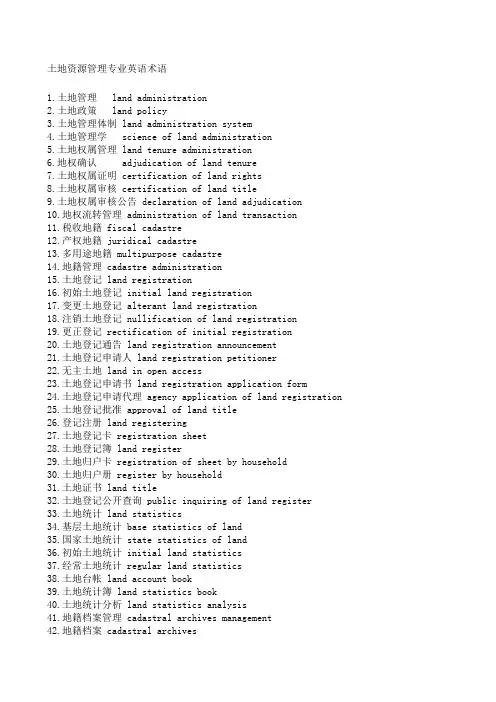
土地资源管理专业英语术语1.土地管理 land administration2.土地政策 land policy3.土地管理体制 land administration system4.土地管理学 science of land administration5.土地权属管理 land tenure administration6.地权确认 adjudication of land tenure7.土地权属证明 certification of land rights8.土地权属审核 certification of land title9.土地权属审核公告 declaration of land adjudication10.地权流转管理 administration of land transaction11.税收地籍 fiscal cadastre12.产权地籍 juridical cadastre13.多用途地籍 multipurpose cadastre14.地籍管理 cadastre administration15.土地登记 land registration16.初始土地登记 initial land registration17.变更土地登记 alterant land registration18.注销土地登记 nullification of land registration19.更正登记 rectification of initial registration20.土地登记通告 land registration announcement21.土地登记申请人 land registration petitioner22.无主土地 land in open access23.土地登记申请书 land registration application form24.土地登记申请代理 agency application of land registration25.土地登记批准 approval of land title26.登记注册 land registering27.土地登记卡 registration sheet28.土地登记簿 land register29.土地归户卡 registration of sheet by household30.土地归户册 register by household31.土地证书 land title32.土地登记公开查询 public inquiring of land register33.土地统计 land statistics34.基层土地统计 base statistics of land35.国家土地统计 state statistics of land36.初始土地统计 initial land statistics37.经常土地统计 regular land statistics38.土地台帐 land account book39.土地统计簿 land statistics book40.土地统计分析 land statistics analysis41.地籍档案管理 cadastral archives management42.地籍档案 cadastral archives43.土地利用管理 land use administration44.土地利用控制 land use control45.土地利用计划管理 planned administration of land use46.土地用途管制 land use regulation47.土地用途管制制度 land use regulation system48.土地利用规划 land use planning49.土地利用总体规划 integrated land use planning50.土地利用专项规划 special –purpose land use planning51.土地开发规划 land development planning52.土地整理规划 land readjustment planning ;land consolidation planning53.土地复垦规划 land reclamation planning54.土地改良规划 land improvement planning55.土地调查 land survey56.土地测量 earth survey ;land survey57.土地资源调查 land resource survey58.地籍调查 cadastral survey59.土地监测 land monitoring60.土地资源组成要素调查 land components survey61.土地条件调查 natural condition survey62.土地类型调查 land type survey63.土地覆被调查 land cover survey64.土地利用调查 land use survey65.宜农荒地调查 agricultural land reserves survey66.耕地后备资源调查 cultivated land reserves survey67.土地普查 land inventory68.路线调查 traverse survey69.样地调查 sample area survey70.综合方法调查 integrated land survey71.勘察性调查 reconnaissance survey72.概略调查 semi-detailed survey73.详细调查 detailed survey74.外业调绘 field investigation and plotting75.作业面积 working area76.直接解译 direct interpretation77.间接解译 indirect interpretation78.内业工作 indoor work79.航空像片转绘 conversion of aerial photograph80.专题成图 thematic mapping81.土地面积量算 area measurement82.初始地籍调查 initial cadastral survey83.变更地籍调查 conversion cadastral survey84.土地产权调查 adjudication investigation85.宗地 cadastral parcel权属界址线所封闭86.混合宗地 co-ownership parcel87.破宗地 separate parcel图斑单一地类地块或有行政界线权属界址线火线撞地类地物分割的单一. 制图最小单元分子表示图斑分母地类.容积率总建筑面积比土地面积..88.邻宗地 adjoining parcel89.飞地 non-continuous parcel独立于其行政区域外90.插花地 mosaic parcel没有明确归属91.宗地合并 amalgamation of cadastral parcel92.宗地分割 subdivision of cadastral parcel93.宗地编号 title number94.宗地位置 location of cadastral parcel95.界址点 boundary point宗地权属界址线的转折点96.界址线 boundary line宗地四周的权属界线97.四至 relative location of adjoining parcels每宗地四邻的名称98.指界 demarkation of cadastral parcel通过相邻双方权利人和地籍调查员对权属界址状况进行实地调查,并予以确认的过程99.地籍测量 cadastral survey100.图解地籍测量 graphic method of cadastral survey101.数值地籍测量 coordinative method of cadastral survey102.地籍控制测量 cadastral control survey103.地籍平面控制测量 horizontal control of cadastral surveying104.地籍高程控制测量 vertical control of cadastral surveying105.地籍细部测量 detailed cadastral surveying106.地籍图根控制测量 supplementary control of cadastral survey107.平面控制点 horizontal control point具有平面坐标值的控制点控制点以一定精度测定其位置的固定点108.图根控制点 supplementary boundary point109.地籍补测 renewal cadastral surveying 修测补测全测110.土地复丈 recertification of initial adjudication111.土地征用定位测量 site survey for land condemnation112.地籍图 cadastral map113.地籍要素 cadastral attributes114.基本地籍图 basic cadastral map115.基本地籍图更新 renewal of basic cadastral map116.宗地图 parcel map117.土地信息 land information118.土地信息系统 land information system119.基础数据库 basic database120.空间数据库 spatial database121.矢量格式空间数据 vector format spatial data122.网格格式空间数据 grid format spatial data123.属性数据库 attribute database124.土地数据处理 data processingof land125.土地信息应用模型 land information application model126.土地信息应用模型库 mode base of land information application127.规划目标 goal;objectives128.规划指标 targets129.规划区 planning area130.规划期限 planning period131.规划任务书 terms of reference132.土地利用问题 land use problems133.土地利用方针 land use strategy134.土地利用配置 land use allocation135.土地利用规划协调 negotiation of land-use options136.土地利用总体规划方案 integrated land-use plan.土地利用总体规划公告 proclamation of overall land use plan.土地利用总体规划实施 implementation of integrated land use plan.公众参与 public participation140.土地利用平衡表 balance table of land allocation141.土地利用总体规划图 master map of integrated land use plan142.土地利用总体规划文本 main report of integrated land use plan143.土地利用总体规划说明 specification of integrated land use plan144.土地管制分区 land use zoning145.土地利用分区 land use regionalization146.土地用途管制规则 zoning regulations147.土地利用计划 land use plan148.土地利用年度计划 annual land use plan149.土地利用中期规划 medium-term land use plan150.建设用地管理 building land regulations151.建设用地预审制度 pre-examination system for building land152.建设用地审批制度 permission system for building land153.建设用地备案制度 recordation system for building land154.建设用地审批权限 limits of authority for building land examination 155.建设供地目录 catalogue for building land supply156.建设用地定额 quota for building land supply157.土地市场管理 land market administration ;land market control158.土地估价师制度 land valuer registration system159.地价公告制度 land price proclamation system160.地价申报制度 land price declaration system161.最低、最高限价制度 land price ceilings system162.优先购买权制度 preemptive right system163.土地信息管理 land information management164.数据标准化 data standardization165.编码标准化 code standardization166.网络协议 network protocol167.土地执法 law enforcement on land168.土地监察 land supervision169.土地违法行为 illegal act against civil laws170.民事违法行为 illegal act against civil laws171.犯罪 criminal act172.土地行政处理 conduct by land administrative order173.土地行政处罚 administrative punishment for illegal act on land174.土地行政强制执行 compulsory enforcement to land administrative order 175.土地行政诉讼 litigation for land administrative order176.土地行政复议 judicial review of land administrative order。
地理信息科学专业英语书后单词

Spatial interpolation 空间插值 standard query language(SQL)标准化查询语言
Polygon 多边形 proximity analysis 邻近域分析
Data structures 数据结构 information retrieval 信息检索
Topological modeling 拓扑建模 network analysis网络分析
Overlay 叠置 data output 数据输出
7、remote sensing 遥感 பைடு நூலகம் sensor 传感器
Electromagnetic radiation 电磁辐射 radiometer 辐射计
Electro-optical scanner 光学扫描仪 radar system 雷达系统
high resolution visible(HRV)sensors 高分辨可视成像传感器
Charge-coupled devices (CCDs)电荷耦合器件
panchromatic(PLA)全色 multispectral(MLA)多波段
WFI(Wide Field Imager)广角成像仪 earth observing system(EOS)地球观测系统
CBERS(China-Brazil Erath Resources Satellite)中巴地球资源卫星
IRMSS(Infrared Multispectral Scanner) 红外多光谱扫描仪
Disaster management 灾害管理 public health 公共卫生
地信英文术语
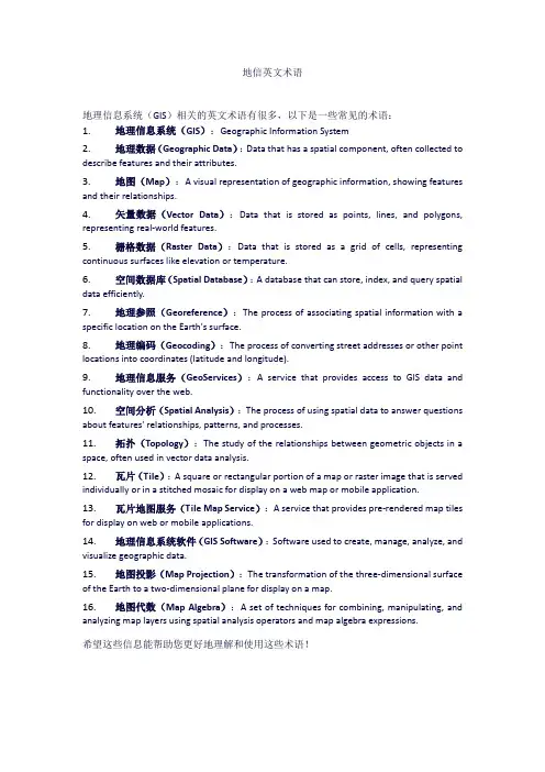
地信英文术语地理信息系统(GIS)相关的英文术语有很多,以下是一些常见的术语:1.地理信息系统(GIS):Geographic Information System2.地理数据(Geographic Data):Data that has a spatial component, often collected to describe features and their attributes.3.地图(Map):A visual representation of geographic information, showing features and their relationships.4.矢量数据(Vector Data):Data that is stored as points, lines, and polygons, representing real-world features.5.栅格数据(Raster Data):Data that is stored as a grid of cells, representing continuous surfaces like elevation or temperature.6.空间数据库(Spatial Database):A database that can store, index, and query spatial data efficiently.7.地理参照(Georeference):The process of associating spatial information with a specific location on the Earth's surface.8.地理编码(Geocoding):The process of converting street addresses or other point locations into coordinates (latitude and longitude).9.地理信息服务(GeoServices):A service that provides access to GIS data and functionality over the web.10.空间分析(Spatial Analysis):The process of using spatial data to answer questions about features' relationships, patterns, and processes.11.拓扑(Topology):The study of the relationships between geometric objects in a space, often used in vector data analysis.12.瓦片(Tile):A square or rectangular portion of a map or raster image that is served individually or in a stitched mosaic for display on a web map or mobile application.13.瓦片地图服务(Tile Map Service):A service that provides pre-rendered map tiles for display on web or mobile applications.14.地理信息系统软件(GIS Software):Software used to create, manage, analyze, and visualize geographic data.15.地图投影(Map Projection):The transformation of the three-dimensional surface of the Earth to a two-dimensional plane for display on a map.16.地图代数(Map Algebra):A set of techniques for combining, manipulating, and analyzing map layers using spatial analysis operators and map algebra expressions.希望这些信息能帮助您更好地理解和使用这些术语!。
地理信息科学专业英语
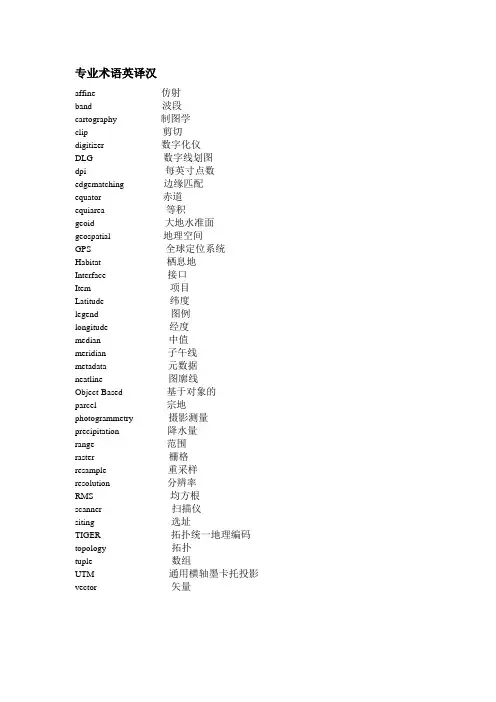
专业术语英译汉affine 仿射band 波段cartography 制图学clip 剪切digitizer 数字化仪DLG 数字线划图dpi 每英寸点数edgematching 边缘匹配equator 赤道equiarea 等积geoid 大地水准面geospatial 地理空间GPS 全球定位系统Habitat 栖息地Interface 接口Item 项目Latitude 纬度legend 图例longitude 经度median 中值meridian 子午线metadata 元数据neatline 图廓线Object-Based 基于对象的parcel 宗地photogrammetry 摄影测量precipitation 降水量range 范围raster 栅格resample 重采样resolution 分辨率RMS 均方根scanner 扫描仪siting 选址TIGER 拓扑统一地理编码topology 拓扑tuple 数组UTM 通用横轴墨卡托投影vector 矢量专业术语汉译英保护区protected area比例尺Scale bar标准差Standard deviation标准图幅Standard picture frame单精度Single precision地理空间数据Geospatial data点缓冲区Point buffer动态分段Dynamic segmentation度量标准Metrics多项式变换Polynomial transformation高程基准Elevation base跟踪算法Tracking algorithm规则格网Rules grid过渡带Transition zone基于位置服务Based on location service 畸形线Malformation line几何变换Geometric transformation检验图Inspection chart解析几何Analytic geometry空间要素Space element平面坐标系统Planar coordinate system曲流河Meandering river人口普查地段Census Lot上四分位数The upper quartile矢量数据模型Vector data model数据可视化data visualization数据探查Data exploration双精度Double precision水文要素Hydrological elements泰森多边型Tyson Polygons统一建模语言Unified Modeling Language投影坐标系统Projection coordinate system 线缓冲区Line buffer遥感数据Remote sensing data用材林Timber forest晕渲法Halo rendering method指北针Compass属性表Property sheet最短路径分析Shortest path analysis最小二乘法Least squares method翻译例子如下。
GIS专业英语词汇

通过一通信链路的数据量。图像数据通常比较大, 所以在不同机器间传输图像数据时序较
大的带宽,否则性能则将很差。
Base map
包含地理特征物用来定位的地图。如道路,通常都存放于基图中。
Base table
存放于数据库中的物理表 。 比较View (视图)。
Band rate
一组用来将图幅中的弧段与其他弧对准进而将其属性传给他们的函数和过程。对准在属性
传递之前进行。
Connectivity
记录起始终止结点的连接段的拓扑标识。有共同结点的弧段是相连的。见arc-node topol
ogy。
Contiguity
记录相邻多边形的各条边的左右多边形来标识相邻多边形的拓扑标识。见polygon –arc
用来指定跨片边界的特征的方法,跨片边界的特征存储于每个片中而不作为一个单独的特
征存储。
CSSM
空间元数据内容标准。由FGDC (联邦地学数据委员会)发布的描述空间元数据格式的文件。
Cursor
1。终端上指向某一处的鼠标图形箭头。
2。数据库中指向表中一条记录的一个内部指针,为处理选择的记录提供一种机制,光标逐
z) 坐标代表了地球表面上点与其他地点的相对位置。 见vector 和 cartesian coordina
te system 。
Coordinate system
用来在平面上测量水平和垂直距离的参照系,一个坐标系通常由地图工程,球体参照,一
个常数,一条或多条平行线,一个中心点和x,y 方向来定义,以确定点,线,面特征的位
写而其他用户只读。其他用户要写时只能等到第一个用户完成它的事务处理之后。
地理信息系统专业英语(全书翻译)
地理信息系统专业英语(全书翻译)
引言
本书是一本关于地理信息系统(Geographic Information System,简称GIS)专业英语的全书。
本书旨在帮助研究GIS的学生和从业
人员提高他们的英语听说读写技能,使他们能够流利地进行专业交
流和文献阅读。
全书内容包括以下几个部分:
第一部分:地理信息系统基础
本部分介绍了地理信息系统的基本概念和原理,包括地理数据、地图投影、地理空间分析等内容。
通过研究本部分的内容,读者可
以了解GIS的基础知识,并掌握相关的专业英语表达。
第二部分:地理信息系统应用领域
本部分介绍了地理信息系统在不同应用领域的具体应用,包括
土地利用规划、城市规划、环境保护等。
读者可以了解不同领域中
的GIS应用案例,并研究相关的专业英语表达。
第三部分:地理信息系统技术与工具
本部分介绍了地理信息系统的常用技术和工具,包括GIS软件、地理数据库、数据采集与处理等。
读者可以了解不同的GIS技术和
工具,并研究相关的专业英语表达。
第四部分:地理信息系统发展趋势与挑战
本部分介绍了地理信息系统的发展趋势和挑战,包括云计算、
大数据、人工智能等新技术对GIS的影响。
读者可以了解GIS领域的最新发展动态,并研究相关的专业英语表达。
结论
本书通过全面介绍地理信息系统的相关知识,帮助读者提高英
语水平和专业素养。
读者通过学习本书,可以更好地理解和应用地
理信息系统,并与国际同行进行有效的交流。
地理专业词汇英语翻译(27)
地理专业词汇英语翻译(27)geodetic satellite 测地卫星geodetic survey 大地测量geodetic zenith 大地天顶geodetics 测地学geodimeter 光电测距仪geodynamics 地球动力学geoenergetic theory 地球能量论geoflexure 地球褶皱geognosy 地球构造学geographic azimuth 地理方位角geographic coordinate net 地理坐标格网geographic coordinate values 地理坐标值geographic coordinates 地理坐标geographic cycle 地理循环geographic data 地理资料geographic data base 地理资料库geographic data handling 地理数据外理geographic elements 地理要素geographic information 地理信息geographic information system 地理信息系统geographic latitude 地理纬度geographic longitude 地理经度geographic meridian 地理子午线geographic name 地理名称geographic network 地理坐标网geographic north 地理北geographic pathology 地理病理学geographical components 地理成分geographical distribution 地理分布geographical environment 地理环境geographical information system 地理信息系统geographical isolation 地理隔离geographical landscape 地理景观geographical map 地图geographical position 地理位置geographical variation 地理变异geographical vicariad 地理的替代种geographical zonality 地理地带性geographical zonation 地理地带性geographical zone 地理带geography 地理学geohistory 地史学geohydrology 水文地质学geoid 地球体geoidal height 大地水准面高geoisotherm 等地温线geologic barometer 地质压力计geologic column 地质柱状图geologic map 地质图geologic time scale 地质年代表geological aerosurvey 地质航空勘测geological age 地质时代geological column map 地质柱状地图geological cycle 地质回旋geological environment 地质环境geological formation 地质建造geological map of bed rocks 基岩地质图geological profile 地质剖面geological remote sensing 地质遥感geological reserves 地质储量geological structure 地质构造geology 地质学geomagnetic axis 地磁轴geomagnetic latitude 地磁纬度geomagnetic pole 地磁极geomagnetic reversal 地磁反向geomagnetism 地磁geometer 测地仪geometric correction 几何校正geometric distortion 几何畸变geometric generalization 几何综合geometric mean 几何平均geomicrobiological prospecting 地球微生物探矿geomicrobiology 地球微生物学geominating capacity 发芽能力geomorphic contrasts 地貌衬度geomorphic history 地貌发展史geomorphic levels 地貌水准面geomorphologic agent 地貌营力geomorphologic map 地形图geomorphological profile 地貌剖面geomorphological regionalisation 地貌的区域化geomorphology 地形学geonomics 经济地理学geony 地原学geophagia 食土癖geophagy 食土癖geophone 地震检波器geophotogrammetry 地面摄影测量术geophysical prospecting 地球物理勘探geophysics 地球物理学geophysiography 地球学geophyte 地下芽植物geophytes 地下芽植物geopotential 重力势geoscopy 测地学geospheres 陆圈geostationary meteorological satellite 地球静止气象卫星geostationary meteorological satellite system 地球静止气象卫星系统geostationary operational environmental satellite 同步环境实用卫星geostationary orbit 地球静止轨道geostationary satellite 地球静止卫星geostratigraphy 全球地层学geostrophic current 地转风气流geostrophic wind 地转风geosuture 地缝合线geosynclinal area 地槽区geosynclinal belt 地槽带geosynclinal system 地槽系geosyncline 地槽geotechnical system 地质工学系geotechnics 土工学geotechnological regionalization 地学工程技术区划geotectonic geology 大地构造地质学geotectonic map 大地构造图geotectonics 构造地质学geotecture 大地构造geothermal gradient 地温梯度geothermal remote sensing 地热遥感geothermal well 地热井坑geothermy 地热geotropism 向地性germ 萌芽german measles 风疹germanium 锗germicide 杀菌剂germinating ability 发芽能力germination 发芽geyser 间歇泉geyserite 硅华ghost echo 回波giant's kettle 瓯穴giantism 巨人症gibbsite 三水铝矿gigantism 巨人症gilgai 粘土小洼地gismondite 多水高岭土glacial 冰河的glacial amphitheater 粒雪盆glacial anticyclone 冰原反气旋glacial cycle 冰川旋回glacial denudation 冰蚀glacial deposit 冰川沉积glacial erosion 冰蚀glacial erosion cycle 冰蚀轮回glacial erosion lake 冰蚀湖glacial flora 冰川植物群glacial forms of relief 冰川地形glacial geology 冰川地质学glacial lake 冰川湖glacial moulin 冰川磨glacial period 冰纪glacial polish 冰川磨片glacial pot hole 冰川穴glacial scratches 冰川擦痕glacial stage 冰川期glacial stairway 冰蚀谷阶梯glacial steps 冰蚀谷阶梯glacial stream 冰河glacial stria 冰川擦痕glacial till 冰碛物glacial trough 冰川槽glacial valley 冰蚀谷。
地理信息系统专业英语
1.Where does the word Geomatics come from? GEODESY+GEOINFORMATICS =GEOMATICS or GEO –for earth and –MATICS for mathematical or GEO- for Geoscience and –MATICS for informatics. It has been said that geomatics is many things to many people . The term geomatics emerged first in Canada and as an academic discipline; it has been introduced worldwide in a number of institutes of higher education during the past few years, mostly by renaming what was previously called “geodesy” or “surveying”, and by-adding a number of computer science- and/ or GIS-oriented courses.地质这个词在哪里地质从何而来?大地测量+教育或地理=地球,地球和-双语对照查看数学或地理-双语对照查看地质灾害与信息学。
有人说地球对于许多人来说意味许多东西。
地球这个词作为学术纪律第一次出现在加拿大; 在过去几年中,现已引进大量的在全球高等教育学院,大多数是被重命名以前被称为“大地测量”或“测量”,双语对照查看,许多计算机科学,和/或GIS-导向课程。
2.Data acquisition techniques include field surveying, global positioningsystem (GPS), satellite positioning, and remotely sensed imagery obtained through aerial photography and satellite imagery. It also includes the acquisition of database material scanned from older maps and plans and data collected by related agencies.数据采集技术包括野外调查、全球定位系统(GPS)、卫星定位、遥感图像得到,通过空中摄影和卫星图像。
地理信息科学专业英语课程简介
地理信息科学专业英语课程简介Introduction to Geographic Information Science Professional English Course.1. Course Overview.In the rapidly evolving field of Geographic Information Science (GIS), the ability to communicate and understand international research, technologies, and applications is paramount. The Geographic Information Science Professional English Course aims to equip students with the linguistic skills necessary to engage effectively in the global GIS community. This course focuses on enhancing students' reading, writing, speaking, and listening skills, specifically tailored to the unique vocabulary and terminology of GIS.2. Course Objectives.To introduce students to the fundamental terminologyand concepts of GIS in an English language context.To develop students' ability to read and understand technical documents, research articles, and online resources related to GIS in English.To enhance students' writing skills, enabling them to produce clear and concise technical reports, proposals, and emails in English.To improve students' speaking and listening skills, preparing them for international conferences, collaborations, and presentations.3. Course Content.The course covers a range of topics relevant to GIS, including:Basic terminology and definitions related to GIS, such as spatial data, remote sensing, cartography, and GIS software.Technical concepts and principles of GIS, including spatial analysis, data management, and geospatial databases.Applications of GIS in various fields, such as environmental science, urban planning, transportation, and disaster management.Current trends and developments in GIS, including big data, artificial intelligence, and geospatial analytics.4. Teaching Methods.The course employs a variety of teaching methods to ensure maximum student engagement and learning outcomes:Lectures and presentations: Delivered by experienced GIS professionals, these sessions introduce students to key concepts and terminology.Interactive discussions: Students engage indiscussions to deepen their understanding of GIS conceptsand applications.Reading assignments: Students are assigned technical articles and research papers to read and analyze, cultivating their reading comprehension skills.Writing assignments: Students practice writing technical reports, proposals, and emails, receiving feedback and guidance from instructors.Role-plays and simulations: These activities simulate real-world scenarios, preparing students for international conferences and presentations.5. Course Evaluation.Evaluation of student performance is based on a combination of assessments, including:Quizzes and tests: These assessments evaluate students' knowledge and understanding of GIS terminology and concepts.Reading comprehension exercises: These exercisesassess students' ability to understand and analyzetechnical articles and research papers.Writing assignments: Students submit technical reports, proposals, and emails for evaluation by instructors.Oral presentations: Students present their work infront of their peers, demonstrating their speaking and presentation skills.6. Conclusion.The Geographic Information Science Professional English Course is an integral part of preparing students for a successful career in the global GIS industry. By acquiring the necessary linguistic skills and knowledge, studentswill be able to engage effectively with international colleagues, participate in global projects, and contributeto the advancement of GIS research and applications.。