Using resolution pyramids for watershed image segmentation
基于导数光谱的小麦冠层叶片含水量反演汇编
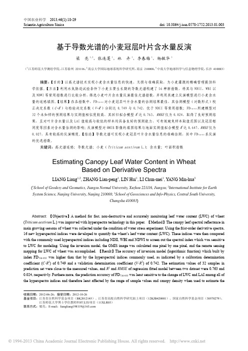
中国农业科学 2013,46(1):18-29Scientia Agricultura Sinica doi: 10.3864/j.issn.0578-1752.2013.01.003基于导数光谱的小麦冠层叶片含水量反演梁 亮1,2,张连蓬1,林 卉1,李春梅1,杨敏华3(1江苏师范大学测绘学院,江苏徐州 221116;2南京大学国际地球系统科学研究所,南京 210008;3中南大学地球科学与信息物理学院,长沙 410083)摘要:【目的】以高光谱技术实现小麦含水量信息的快速、无损与准确获取,为小麦灌溉的精确管理提供科学依据。
【方法】利用水氮胁迫试验条件下小麦主要生长期的导数光谱构建了16种新指数,将其与NDII、WBI以及NDWI等常用指数进行比较分析,筛选小麦叶片含水量反演最佳光谱指数,并利用其建立反演模型进行小麦含水量的遥感填图。
【结果】在各指数中,FD730-955对小麦冠层叶片含水量的估测结果最佳,其估测模型(对数形式)校正决定系数(C-R2)与检验决定系数(V-R2)分别达0.749与0.742,优于NDII等常用指数;FD730-955所建模型对32个未知样的预测结果与实测值相似度较高,其回归拟合模型R2达0.763,RMSE仅为0.024,取得了良好预测结果,且对叶片含水量以及LAI值较高与较低的样本均具备良好的预测能力,可有效避免样本取值范围以及冠层郁闭度等因素对含水量估测的影响;反演模型对OMIS影像的填图结果与地面实测值拟合模型R2达0.647,RMSE仅为0.027,具有较高的反演精度。
【结论】导数光谱可实现小麦冠层叶片含水量信息的准确估测,其中FD730-955系反演的优选指数。
关键词:高光谱遥感;导数光谱;小麦(Triticum aestivum L.);含水量;叶面积指数Estimating Canopy Leaf Water Content in WheatBased on Derivative SpectraLIANG Liang1,2, ZHANG Lian-peng1, LIN Hui1, LI Chun-mei1, YANG Min-hua3(1School of Geodesy and Geomatics, Jiangsu Normal University, Xuzhou 221116, Jiangsu; 2International Institute for EarthSystem Science, Nanjing University, Nanjing 210008; 3School of Geosciences and Info-Physics, Central South University,Changsha 410083)Abstract: 【Objective】A method for fast, non-destructive and accurately monitoring leaf water content (LWC) of wheat(Triticum aestivum L.) was improved with hyperspectra technology in this paper. 【Method】The canopy leaf spectral reflectance inmain growing seasons of wheat was collected under the condition of water stress experiment. Using the frist-order derivative spectra,16 new hyperspectral indices were developed to quantify the wheat’s leaf water content (LWC). These indices were then comparedwith the commonly used hyperspectral indices including NDII, WBI and NDWI to screen out the spectral index which was sensitiveto LWC for modeling. Using the inversion model, the OMIS image was calculated one pixel by one pixel, and the remote sensingmapping for LWC of wheat was accomplished. 【Result】The accuracy of inversion model (logarithmic function) which built byindex FD730-955 was higher than that by the hyperspectral indices commonly used, as indicated by a calibration determinationcoefficient (C-R2) of 0.749 and a validation determination coefficient (V-R2) of 0.742. The eatimation values of 32 samples inprediction set were close to the measured values, and R2 and RMSE of regression fitted model between two dataset were 0.763 and0.024, respectivly. Furthere more, the prediction accuracy of FD730-955 was least sensitive to the change of LWC and LAI among all ofthe hyperspectra indices and therefore least affected by the range of sample values and canopy density when used to estimate the收稿日期:2012-06-26;接受日期:2012-10-26基金项目:江苏省自然科学基金项目(BK2012145)、江苏省高校自然科学研究面上项目(12KJB420001)、国家自然科学基金项目(30570279)、江苏师范大学博士学位教师科研支持项目(11XLR03)联系方式:梁亮,E-mail:liangliang198119@1期梁亮等:基于导数光谱的小麦冠层叶片含水量反演 19LWC of wheat. The R2 and RMSE of the fitting model for the inversion and measured values were 0.635 and 0.027, respectively, andindicated the similarity between the inversion and measured value was high. 【Conclusion】It is possible to eatimate LWC of wheatby derivative hyperspectra with a high accuracy, and FD730-955 is an optimal index for modeling.Key words: hyperspectra remote sensing; derivative spectrum; wheat (Triticum aestivum L.); leaf water content (LWC); leafarea index (LAI)0 引言【研究意义】叶片含水量是植株水分状况良好的度量和诊断指标,实时、快速地获取叶片含水量信息是进行作物长势监测以及灌溉调控的前提[1]。
Towards Physarum robots computing and manipulating on water surface

Towards Physarum robots: computing and manipulating on water surface Andrew AdamatzkyComputing, Engineering and Mathematical Sciences, University of the West of England, Bristol, United KingdomandBristol Robotics Laboratory, Bristol, United Kingdomandrew.adamatzky@AbstractPlasmodium of Physarym polycephalum is an ideal biological substrate for implementing concurrent and parallel computation, including combinatorial geometry and optimization on graphs. We report results of scoping experiments on Physarum computing in conditions of minimal friction, on the water surface. We show that plasmodium of Physarum is capable for computing a basic spanning trees and manipulating of light-weight objects. We speculate that our results pave the pathways towards design and implementation of amorphous biological robots.Key words: biological computing, amorphous robots, unconventional computation, amoebaIntroductionPlasmodium, the vegetative stage of slime mould Physarum polycephalum, is a single cell, with thousands of diploid nuclei, formed when individual flagellated cells or amoebas of Physarum polycephalum swarm together and fuse. The plasmodium is visible by naked eye. When plasmodium is placed on an appropriate substrate, the plasmodium propagates and searches for sources of nutrients (bacteria). When such sources are located and taken over, the plasmodium forms veins of protoplasm. The veins can branch, and eventually the plasmodium spans the sources of nutrients with a dynamic proximity graph, resembling, but not perfectly matching graphs from the family of k-skeletons [Kirkpatrick and Radke, 1985].A large size of the plasmodium allows the single cell to be highly amorphous. The plasmodium shows synchronous oscillation of cytoplasm throughout its cell body, and oscillatory patterns control the behaviours of the cell. All the parts of the cell behave cooperatively in exploring the space, searching for nutrients and optimizing network of streaming protoplasm. Due to its unique features and relative ease of experimentation with, the plasmodium became a test biological substrate for implementation of various computational tasks. The problems solved by the plasmodium include maze-solving [Nakagaki, 2000, 2001], calculation of efficient networks [Nakagaki 2003, 2004; Shirakawa & Gunji, 2007], construction of logical gates [Tsuda et al, 2004], formation of Voronoi diagram [Shirakawa & Gunji, 2007a], and robot control [Tsuda et al., 2007].The oscillatory cytoplasm of the plasmodium can be seen as a spatially extended nonlinear excitable media [Matsumoto et al., 1988; Nakagaki et al., 1999; Yamada et al., 2007]. In our previous papers we hypothesized that the plasmodium of Physarum is a biological analogue of a chemical reaction-diffusion system encapsulated in an elastic and growing membrane [Adamatzky, 2007a]. Such an encapsulation enables the plasmodium to function as a massively-parallel reaction-diffusion computer [Adamatzky, De Lacy Costello, Asai, 2005] and also to solve few tasks which reaction-diffusion computers could not do, e.g. construction of spanning trees [Adamatzky, 2007], and implementation ofstorage modification machines [Adamatzky, 2008]. Also, under certain experimental conditions, the plasmodium exhibits travelling self-localizations, implements collision-based logical circuits and thus is capable for universal computation [Adamatzky, De Lacy Costello, Shirakawa, 2008].Being encapsulated in an elastic membrane the plasmodium can be capable of not only computing over spatially distributed data-sets but also physically manipulating elements of the data-sets. If a sensible, controllable and, ideally, programmable movement of the plasmodium and manipulation by the plasmodium could be achieved, this would open ways for experimental implementations of amorphous robotic devices. There are already seeds of an emerging theory of artificial amoeboid robots [Yokoi and Kakazu, 1992; Yokoi et al., 2003; Shimizu and Ishiguro, 2008].In present paper we undertook a set of scoping experiments on establishing links between Physarum computing and Physarum robotics. We have chosen water surface as a physical substrate for the plasmodium development to study how topology of the plasmodium network can be dynamically updated, without being stuck to a non-liquid substrate, and how small objects floating on the surface can be manipulated by the plasmodium’s pseudopodia.MethodsPlasmodium of Physarum polycephalum was cultivated on a wet paper towels in dark ventilated containers, oat flakes were supplied as a substrate for bacteria on which the plasmodium feeds. We used several test arenas for observing behaviour of the plasmodium and scoping experiments on plasmodium-induced manipulation of floating objects. These are Petri dishes with base diameters 20 mm and 90 mm, and rectangular plastic containers 200 by 150 mm. The dishes and containers were filled by 1/3 with distilled water. Data points, to be spanned by the plasmodium, were represented either by 5-10 mm sized pieces of a plastic foam, which were either fixed to bottom of Petri dishes or left floating on water surface (in case of large containers). Oat flakes were placed on top of the foam pieces. Foam pieces, where plasmodium was initially placed, and the pieces with oat flakes were anchored to bottom of containers. Tiny foam pieces to be manipulated by plasmodium were left free-floating.Results: Computing and ManipulatingTo demonstrate that a substrate is suitable for robotics implementations one must demonstrate that the substrate is capable for sensing of environment and responsiveness to external stimulus, solving complex computational tasks on spatially distributed data sets, locomotion, and manipulation of objects. We provide basic demonstrations which may indicate that plasmodium of Physarum polycephalum can be successfully used in future experiments on laboratory implementations of amorphous biological robots.Surface of water is in tension therefore it physically supports propagating plasmodium, when its contact weight to contact area ratio is small. When placed in an experimental container the plasmodium forms pseudopodia aimed to search for sources of nutrients. In most experiments ‘growth part’ of the pseudopodia has tree-like structure for fine detection of chemo-gradients in the medium, which also minimized weight to area ratio. Examples of tree-like propagating pseudopodia are shown in Fig. 1.In Fig. 1b we can see that not always pseudopodia grow towards source of nutrients, there is a pseudopodia growing South-West, where no sources of nutrients located. This happens possibly because in large-sized containers volume of air is too large to support a reliable and stationary gradient of chemo-attractants. This may pose a difficulty for the plasmodium to locate and span all sources of nutrients in large-sized containers.In Petri dishes volume of air is small and, supposedly the air is stationary, therefore plasmodium easily locates sources of nutrients (Fig. 2). It thus builds spanning trees where graph nodes (to be spanned)are presented by pieces of foam with oat flakes on top. In Fig. 2 we can see that originally the plasmodium was positioned at the Southern domain. In twelve hours the plasmodium builds a link with Western domain, and then starts to propagate pseudopodia to the Eastern domain.When the plasmodium spans sources of nutrients, it produces many ‘redundant’ branches (Fig. 2). These branches of pseudopodia are necessary for space exploration but do not represent minimal edges connecting the nodes of the spanning tree. These ‘redundant’ branches are removed at later stages of the spanning tree development. See a well-established spanning tree of data-points in Fig. 3. Initially the plasmodium was placed in the Western domain, and the plasmodium has constructed the spanning tree in 15 hours.We demonstrated that the plasmodium does explore space and computes a spanning tree on the water surface, when placed initially on one of the floating objects. Would the plasmodium be as well operational when placed just on the surface of the water? As we can see in Fig. 4 the plasmodium works perfectly. We placed a piece of plasmodium on bare surface of water (Fig. 4, start). In three hours the plasmodium forms an almost circular front of propagating pseudopodia, which reach two stationary domains with oat reaches in eight hours (Fig. 4).In usual conditions (on a wet solid or gel substrate) edges of spanning trees, presented by protoplasmic tubes, adhere to the surface of the substrate [Nakagaki et al., 2003; Adamatzky, 2007, 2008]. Therefore the edges cannot move, and the only way the plasmodium can do a dynamical update is to make a protoplasmic tube inoperative and to form a new edge instead (membrane shell of the ceased link will remain on the substrate, e.g. see [Adamatzky, 2008]). When plasmodium operates on water surface, cohesion between the water surface and membrane of protoplasmic tubes is small enough for the protoplasmic tubes to move freely. Thus the plasmodium can make the tubes almost straight and thus minimize costs of the transfer and communication between its distant parts. Two examples of the straightening of the protoplasmic tubes are shown in Fig. 5. Such straightening is a result of the tubes’ becoming shorter due to contraction.Presence of a contraction may indicate that if two floating objects (both with sources of nutrients) are connected by a protoplasmic tube then the objects will be pulled together due to shortening of the protoplasmic tube. We did not manage to demonstrate this exact phenomenon of pulling two floating objects together, however we got experimental evidence of pushing and pulling of single floating objects by the plasmodium’s pseudopodia.The plasmodium-induced pushing and pulling are exemplified in Figs. 6 and 7.To demonstrate pushing we placed a very light-weight piece of plastic foam on the water surface nearby the plasmodium (Fig. 6, 0 hours). The plasmodium develops a pseudopodium which propagates towards the light-weight piece of foam (Fig. 6, 5 hours). Due to gravity force acting on the pseudopodia a ripple is formed on the water surface (Fig. 6, 9 hours), which causes pushes the piece of foam away from the growing pseudopodia’s tip (Fig. 6, 13 hours). Due to absence of any nutrients on the pushed piece of foam, the plasmodium abandons its attempt to occupy the piece and retracts the pseudopodia (Fig. 6, 16 hours). The piece remains stationary: it became shifted away from its original position.In the second example, Fig. 7, we observe pulling of the light-weight object. The piece of foam to be pulled is placed between two anchored objects (Fig. 7, 0 hours). One object hosts the plasmodium another object has an oat flake on top (i.e. attracts the plasmodium). A pseudopodium grows from the plasmodiu m’s original location towards the site with the source of nutrients. The pseudopodium occupies the piece of foam (Fig. 7, 15 hours) and then continues its propagation towards the source of nutrients. When the source of nutrients is reached (Fig. 7, 22 hours) the protoplasmic tubes connecting two anchored objects contract and straighten thus causing the light-weight object to be pulled towards the source of nutrients (Fig. 7, 32 hours). The pushing and pulling capabilities of the plasmodium can be utilized in constructions of water-surface based distributed manipulators [Hosokawa et al., 1996; Adamatzky et al., 2005].DiscussionInspired by biomechanics of surface walking insects, see e.g. [McAlister, 1959; Suter et al., 1997, Suter, 1999; Suter and Wildman, 1999], our previous studies on implementation of computing tasks in the plasmodium [Adamatzky, 2007, 2008], and our ideas on design and fabrication of biological amorphous robots [Kennedy et al., 2001] we decided to explore operational capabilities of plasmodium of Physarum polycephalum on the water surface. We were interested to demonstrate that the plasmodium possesses the essential features of distributed robotics devices: sensing, computing, locomotion and manipulation.Why water surface? We have chosen water surface as an experimental substrate because there is minimal friction and cohesions between the plasmodium’s pseudopodia and the surface, always near ideal humidity for the plasmodium, continuous removal of metabolites and excretions from the plasmodium’s body and protoplasmic tubes, increases chances of achieving manipulation of objects by the plasmodium.We demonstrated experimentally that the plasmodium (1) senses data-objects represented by sources of nutrients, (2) calculates shortest path between the data-objects, and approximates spanning trees where the data-objects are nodes (in principle, a spanning tree of slowly moving data-objects can be calculated as well), (3) pushes and pulls light-weight objects placed on the water surface. The findings indicated that the plasmodium of Physarum polecephalum is a perspective candidate for the role of spatially extended robots implemented on biological substrates.Our experiment also show that Physarum implementation of Kolmogorov-Uspensky machine [Adamatzky, 2008] can be extended to mechanical version of the storage modification machine by adding P USH NODE and P ULL NODE operations. To translocate nodes selectively in the storage structures we may need to assign certain attributes. This can be done by marking nodes with different species of colors; in [Adamatzky, 2008] we demonstrated that the plasmodium exhibits strong preferences to certain food colouring, is neutral to others, and that some food colourings repel the plasmodium. Such preference hierarchy can be mapped onto the mobile data storage structure.More future experiments is required indeed to develop ideas derived from our scoping experiments to the full working prototypes of the Physarum robots and mechanical Kolmogorov-Uspenski machines. References[Adamatzky, De Lacy Costello, Asai, 2005] Adamatzky A., De Lacy Costello B., Asai T. Reaction-Diffusion Computers. Elsevier, 2005.[Adamatzky, 2007] Adamatzky A. Approximation of of spanning trees in plasmodium of Physarum polycephalum. Kybernetes (2007), in press.[Adamatzky, 2007a] Adamatzky A. Physarum machines: encapsulating reaction-diffusion to compute spanning tree. Naturwisseschaften (2007).[Adamatzky, 2008] Adamatzky A. Physarum machine: implementation of a Kolmogorov-Uspensky machine on a biological substrate. Parallel Processing Letters 17 (2008).[Adamatzky, De Lacy Costello, Shirakawa, 2008] Adamatzky A., De Lacy Costello B., Shirakawa T.Universal computation with limited resources: Belousov-Zhabotinsky and Physarum computers. Int. J. Bifurcation and Chaos (2008), in press.[Hosokawa et al., 1996] Hosokawa K., Shimoyama I., Miura H. Two-dimensional micro-self-assembly using the surface tension of water. Sensors and Actuators A 57 (1996) 117-125. [Kennedy, Melhuish, Adamatzky, 2001] Kennedy B., Melhuish C. and Adamatzky A. (2001) Biologically Inspired Robots in In: Y. Bar-Cohen, Editor, Electroactive polymer (EAP) actuators -- Reality, Potential and challenges. SPIE Press[Kirkpatrick and Radke, 1985] Kirkpatrick D.G. and Radke J.D. A framework for computational morphology.In:Toussaint G. T., Ed., Computational Geometry (North-Holland, 1985) 217-248.[Matsumoto et al., 1988] Matsumoto, K., Ueda, T., and Kobatake, Y. (1988). Reversal of thermotaxis with oscillatory stimulation in the plasmodium of Physarum polycephalum. J. Theor. Biol.131, 175–182. [McAlister, 1959] McAlister WH. 1959. The diving and surface-walking behaviour of Dolomedes triton sexpunctatus (Araneida: Pisauridae). Animal Behaviour 8: 109-111.[Nakagaki et al., 1999] Nakagaki T., Yamada H., and Ito M. (1999). Reaction–diffusion–advection model for pattern formation of rhythmic contraction in a giant amoeboid cell of the Physarum plasmodium J. Theor. Biol., 197, 497-506.[Nakagaki et al., 2000] Nakagaki T., Yamada H., and Toth A., Maze-solving by an amoeboid organism.Nature 407 (2000) 470-470.[Nakagaki 2001] Nakagaki T., Smart behavior of true slime mold in a labyrinth. Research in Microbiology 152 (2001) 767-770.[Nakagaki et al 2001] Nakagaki T., Yamada H., and Toth A., Path finding by tube morphogenesis in an amoeboid organism. Biophysical Chemistry 92 (2001) 47-52.[Nakagaki et al 2003] Nakagaki, T., Yamada, H., Hara, M. (2003). Smart network solutions in an amoeboid organism, Biophys. Chem., 107, 1-5.[Nakagaki 2004] Nakagaki, T., Kobayashi, R., Nishiura, Y. and Ueda, T. (2004). Obtaining multiple separate food sources: behavioural intelligence in the Physarum plasmodium, Proc. R. Soc.Lond. B, 271, 2305-2310.[Shimizu and Ishiguro, 2008] Shimizu M. and Ishiguro A. Amoeboid locomotion having high fluidity by a modular robot. Int. J. Unconventional Computing (2008), in press.[Shirakawa & Gunji, 2007] Shirakawa, T., and Gunji, Y.-P. (2007). Emergence of morphological order in the network formation of Physarum polycephalum, Biophys. Chem., 128, 253-260. [Shirakawa & Gunji, 2007a] Shirakawa T. And Gunji Y.–P. Computation of Voronoi diagram and collision-free path using the Plasmodium of Physarum polycephalum.Int. J. Unconventional Computing (2007), in press.[Adamatzky et al., 2005] Adamatzky A., De Lacy Costello B., Skachek S., Melhuish C. Manipulating planar shapes with a light-sensitive excitable medium: computational studies of close-loop systems. Int. J. Bifurcation and Chaos 350 (2006) 201-209.[Suter and Wildman, 1999] Suter RB, Wildman H. 1999. Locomotion on the water surface: hydrodynamic constraints on rowing velocity require a gait change. Journal of Experimental Biology 202: 2771-2785.[Suter, 1999] Suter RB. 1999. Cheap transport for fishing spiders: the physics of sailing on the water surface. Journal of Arachnology 27: 489-496.[Suter et al., 1997] Suter RB, Rosenberg O, Loeb S, Wildman H, Long J Jr. 1997. Locomotion on the water surface: propulsive mechanisms of the fisher spider, Dolomedes triton. Journal of Experimental Biology 200: 2523-2538.[Tsuda et al., 2004] Tsuda, S., Aono, M., and Gunji, Y.-P., Robust and emergent Physarum computing.BioSystems 73 (2004) 45–55.[Tsuda et al., 2007] Tsuda, S., Zauner, K. P. and Gunji, Y. P. Robot control with biological cells.Biosystems,87, (2007) 215-223[Yokoi and Kakazu, 1992] Yokoi H. and Kakazu Y. Theories and applications of autonomic machines based on the vibrating potential method, In: Proc. Int. Symp. Distributed Autonomous Robotics Systems (1992) 31-38.[Yokoi et al., 2003] H. Yokoi, T. Nagai, T. Ishida, M. Fujii, and T. Iida, Amoeba-like Robots in the Perspective of Control Architecture and Morphology/Materials, In: Hara F. and Pfeifer R.(Eds.) Morpho-Functional Machines: The New Species, Springer-Verlag Tokyo, 2003, 99–129.FIGURESa bFig. 1. The plasmodium explores experimental arena by propagating tree-like pseudopodia.Start 12 hoursFig. 2. Plasmodium builds links connecting its original domain of residence with two new sites.Fig.3. Spanning tree of three points constructed by the plasmodium.Start 3 hours5 hours 8 hoursFig. 4. Plasmodium starts its development on the water surface and occupies two sources of nutrients.a b (12 hours later)c d (12 hours later)Fig. 5. Examples of straightening of protoplasmic tubes. In photographs (a) and (c) tubes are longer than necessary. In photographs (b) and (d) the tubes correspond to minimal shortest path between the sites they are connecting.Fig. 6. Photographs demonstrate that the plasmodium can push light-weight floating objects. The object to be pushed is indicated by white arrow in the first photograph the series.Fig. 7. Photographs demonstrate that the plasmodium can pull lightweight object. The object to be pulled is indicated by white arrow in the first photograph.。
六年级下册英语课外拓展重点单词
六年级下册英语课外拓展重点单词1. conquer [v.] - 征服意思是战胜、征服。
例如:He conquered his fear of heights and climbed to the top of the mountain.2. examine [v.] - 检查意思是仔细检查、审查。
例如:The doctor examined my throat and said it was infected.3. analysis [n.] - 分析意思是对事物的详细分析。
例如:After a careful analysis of the data, we found the cause of the problem.4. species [n.] - 物种意思是生物学上的物种。
例如:There are more than 1,000 species of birds in this forest.5. pollute [v.] - 污染意思是使…受污染。
例如:The factory's waste water is polluting the river.6. civilization [n.] - 文明意思是文明社会或文明程度。
例如:The ancient Egyptian civilization left behind many magnificent structures.7. consume [v.] - 消耗意思是使用或消耗掉。
例如:Each person consumes a large amount of energy every day.8. drought [n.] - 干旱意思是长时间没有降雨的天气状况。
例如:The drought has caused a shortage of water in the region.9. glacier [n.] - 冰川意思是永久积雪形成的冰川。
Nature of Soil–Water Characteristic Curve for Plastic Soils
Nature of Soil–Water Characteristic Curve for Plastic SoilsFernando A.M.Marinho 1Abstract:Determinations of unsaturated soil parameters using experimental procedures are time consuming and difficult.In recent years,the soil–water characteristic curve ͑SWCC ͒has become an important tool in the interpretation of the engineering behavior of unsaturated soils.Difficulties associated with determining such parameters have justified the use of indirect determination.This paper presents the general behavior of the SWCC for plastic soils,in terms of gravimetric water content versus soil suction,according to the soil type,and also the stress history of the soil.In order to investigate possible relationships between the liquid limit ͑w 1͒,suction capacity and SWCC,data from the literature were collected and analyzed.The present study examined 49SWCCs from 18soils.The objectives of the paper were twofold:to contribute to the interpretation and use of the SWCC and to present a simple method for inferring the SWCC for plastic soils,taking into account the stress history of the soil.DOI:10.1061/͑ASCE ͒1090-0241͑2005͒131:5͑654͒CE Database subject headings:Unsaturated soils;Soil water storage;Soil suction;Liquid limit;Stress history .IntroductionThe soil-water characteristic curve ͑SWCC ͒has been used as a tool for predicting the mechanical and hydraulic properties of unsaturated soils.The indirect determination of these parameters may be justified not only by the difficulties involved in such tests but also by the costs associated with determinations of these pa-rameters ͑e.g.,Fredlund 1998͒.The proliferation of SWCC use for indirect determination of unsaturated soil properties is un-avoidable and in some cases desirable.The volume change with increased suction will depend on the initial void ratio and/or the stress history.The shape of the SWCC reflects the influence of stress history on the soil.For this reason,models used for pre-dicting unsaturated soil parameters should consider the influence of the stress history of the soil via the SWCC.An understanding of the phenomena involved in the relationship between water con-tent and suction is paramount for adequate interpretation of the SWCC.One of the objectives of this paper was to contribute to the interpretation and use of the SWCC,which in turn would help in understanding the engineering behavior of unsaturated soils.The SWCC was analyzed in terms of gravimetric water content versus soil suction,according to the soil type and taking into account the stress history of the soil.A further objective was to present a simple method for deducing the SWCC for plastic soils using one water content/suction determination and the liquid limit of the soil.Background to Soil–Water Characteristic Curve The shape of the SWCC depends on the pore size distribution and compressibility of the soil in relation to suction.These two char-acteristics of porous materials are affected by the initial water content,soil structure,mineralogy,and the stress history ͑e.g.,Lapierre et al.1990;Vanapalli et al.1999;Simms and Yanful 2000͒.Most SWCCs are S shaped and the curve shapes are a response to the pore size distribution of the material.For a rigid porous material of single pore size ͑i.e.,uniform pore size distri-bution ͒,whether it is a soil or not,the SWCC should be similar to curve ͑a ͒shown in Fig.1.However,complete water loss with suction increasing beyond the air entry value is not usual.In other words,it is difficult to remove all the water from a porous mate-rial by means of a small increase in suction.Even in a porous material with uniform pore size distribution,some water would still be present in the material due to surface phenomena.The SWCC shape for a material of single pore size could be more appropriately represented by curve ͑b ͒in Fig.1.Nevertheless,for this material even after air entry suction,some water still remains in the soil and for the removal of the residual water higher energy are required.Curve ͑c ͒in Fig.1represents an example of material with two pore sizes.Each of the sizes is associated with one suction value via the capillary phenomenon ͑e.g.,Fredlund and Rahardjo 1993͒.Material with great numbers of pore sizes should present a more gradual reduction in water content with an in-crease in suction,as shown in curve ͑d ͒in Fig.1.By applying the capillary model,the equivalent pore size for the material can be deduced ͑i.e.,from 0.0146to 0.0000146mm ͒.Clay soils typically have nonuniform grain size and pore size distributions ͑e.g.,Delage and Lefebvre 1983͒.As a consequence,linear and less steeply sloping SWCCs ͑using a semilog plot ͒are normally obtained for clays.Clays may experience shrinkage that reduces pore size.Fine-grained soils with a liquid limit greater than 25%typically exhibit significant shrinkage characteristics when dried.This can be observed in Fig.2,in which the liquid limit and shrinkage limit for some soils are presented.This figure also illustrates that the shrinkage limit by itself is not a sufficient parameter for identifying soil behavior.Shrinkage phenomena in1Associate Professor,Dept.of Foundation and Engineering.,Univ.of São Paulo,CED 04318-002Sao Paulo,Brazil.E-mail:fmarinho@usp.br Note.Discussion open until October 1,2005.Separate discussions must be submitted for individual papers.To extend the closing date by one month,a written request must be filed with the ASCE Managing Editor.The manuscript for this paper was submitted for review and pos-sible publication on May 31,2000;approved on September 23,2004.This paper is part of the Journal of Geotechnical and Geoenvironmental Engineering ,V ol.131,No.5,May 1,2005.©ASCE,ISSN 1090-0241/2005/5-654–661/$25.00.654/JOURNAL OF GEOTECHNICAL AND GEOENVIRONMENTAL ENGINEERING ©ASCE /MAY 2005D o w n l o a d e d f r o m a s c e l i b r a r y .o r g b y H a r b i n I n s t i t u t e o f T e c h n o l o g y o n 11/17/13. C o p y r i g h t A S CE .F o r p e r s o n a l u s e o n l y ; a l l r i g h t s r e s e r v e d .clays due to increased suction can play an important role in shap-ing the SWCC.During shrinkage the emptying of pores is accom-panied by reduction in pore size,which keeps the spaces filled with water and increases the air entry value.A reduction in pore size in clays may also occur due to me-chanical overconsolidation.In this case,the air entry value is higher than for the normally consolidated soil,and the SWCC shape for this type of material is relatively flat.Various methods are commonly used when defining the SWCC for a soil from lower to higher suction levels ͑e.g.,McQueen and Miller 1974;Blight and Roussev 1995;Barbour 1998͒.The reason for this is that not all methods used to measure suction can cover all suction ranges.Depending on the method used,total or matric suction is obtained.When a combination of methods is used without paying attention to the type of suction that is being measured,the SWCC shape may be affected if the value of osmotic suction is significant.For suctions up to 30kPa,the pressure plate method with the hanging column is usually convenient.For suctions between 30and 1,500kPa,the pressure plate ͑i.e.,axis-translation technique ͒or filter paper methods can be used.In most high suction range ͑i.e.,greater than 1,500kPa ͒the suction measured is the total suction,regardless of the method used for measurement.Marinho and Chandler ͑1993͒drew attention to the fact that the filter paper,even when in con-tact with the soil,may not have adequate contact with the soil–water and hence this method may measure a combination of total and matric suction.Effect of Soil Plasticity on Soil–Water Characteristic CurveThe influence of soil plasticity on the SWCC has been demon-strated in the literature ͑e.g.,Black 1962;Mitchell and Avalle 1984;Fleureau et al.1990,among others ͒.Results obtained by Marinho and Chandler ͑1993͒showed a relationship between liq-uid limit and suction capacity ͑C ͒for compacted soils.Suction capacity is defined as the reduction in water content ͑expressed in percent ͒over one logarithmic cycle.It has also been suggested that soils prepared from slurries should represent the upper limit of suction capacity for a given soil.There is a unique relationship between soil suction and water content normalized by the suction capacity C ͑i.e.w /C ͒,for dynamically compacted soils.The value of C could be reduced in accordance with the stress history.Har-rison and Blight ͑2000͒emphasized the relationship between C and some soil properties such as plasticity index,clay fraction and linear shrinkage.Harrison and Bligh ͑2000͒observed that,for residual soils,the relationship did not present good correlation.The effect of soil plasticity on the SWCC is displayed sche-matically in Fig.3͑a ͒,showing that the slope of the SWCC changes with the liquid limit when a log scale is used for repre-senting suction.This effect can be compared to the relationship between void ratio and effective overburden pressure for saturated soils presented by Skempton ͑1970͒.The general behavior of clay samples with different stress histories or different preparation pro-cedures is schematically shown in Fig.3͑b ͒.The behavior ob-served is also in agreement with data presented by Croney and Coleman ͑1954͒and Toll ͑1988͒.The SWCC for most soils with a liquid limit of more than 25%can be assumed to be a straight line between suctions of 100and 10,000kPa,on a semilog plot,regardless of the suction method used ͑McQueen and Miller 1974;Marinho and Chandler 1993͒.Some soils,such as residual soils,may present some predomi-nance of void size that induces a change in suction capacity at suction levels within the interval mentioned above.The soil state at the liquid limit has been used for relating soil properties.Burland ͑1990͒introduced the concept of intrinsic properties for saturated clays,which was based on the voidratioFig.1.General shape of soil–water characteristic curve according to pore sizedistributionFig.2.Relation between liquid limit and shrinkage limit for some soils ͓Holtz ͑1959͒;Fleureau et al.͑1993͒;Tuncer ͑1988͔͒Fig.3.Plasticity chartJOURNAL OF GEOTECHNICAL AND GEOENVIRONMENTAL ENGINEERING ©ASCE /MAY 2005/655D o w n l o a d e d f r o m a s c e l i b r a r y .o r g b y H a r b i n I n s t i t u t e o f T e c h n o l o g y o n 11/17/13. C o p y r i g h t A S CE .F o r p e r s o n a l u s e o n l y ; a l l r i g h t s r e s e r v e d .of samples prepared between the liquid limit ͑w L ͒and 1.5w L .The relationship between water content and stress during isotropic consolidation can be obtained provided the specific gravity of the soil is known.The results obtained from drying saturated clay are equivalent to the isotropic consolidation,provided the soil re-mains saturated ͑e.g.,Blight 1965͒.Reddi and Poduri ͑1997͒pre-sented a study in which the void ratio at the liquid limit was used to obtain the water retention properties of the soil at other states.Marinho and Pinto ͑1997͒,in discussing the work presented by Reddi and Poduri ͑1997͒,presented data showing the relationship between w L and the pore size distribution index ͑͒,based on the Brooks and Corey ͑1966͒model for undisturbed soils and soils prepared at the w L .Effect of Stress History on Soil–Water Characteristic CurveCroney and Coleman ͑1954͒were among the first investigators to study the effect of the stress history of the sample on the SWCC.It is clear from the findings of this study that,for the same water content,overconsolidation induces a reduction in suction and as a consequence in suction capacity.The degree of saturation of an overconsolidated sample is always higher than that of a normally consolidated soil,provided the suction is higher than the air entry value of the normally consolidated sample.Toll ͑1988͒performed a series of tests and described the soil behavior during desatura-tion,presenting a framework for examining the relationship be-tween water content and volume change with suction.Toll ͑1988͒also presented the concept of a virgin desaturation line ͑VDL ͒,which is the line where,for some value of suction,the relation-ship between water content and logarithm of suction is unique ͓see Fig.3͑b ͔͒.The point at which soils in different initial states reach the VDL is associated with the air entry value.Delage and Lefebvre ͑1983͒used mercury intrusion porosimetry to show the effect of the stress history on the air entry value of plastic soils.Tests were performed on St.Marcel clay,consolidated at different stress levels,including dried samples.The results clearly indi-cated that the air entry value increases with the consolidationpressure and is even higher for samples previously dried.It should be pointed out that the air entry value increases with the overconsolidation of the soil but,as for saturated soils,the stress required to reach the same water content is lower.Vanapalli et al.͑1999͒performed a series of tests using a sandy clay till ͑Indian Head till ͒to deduce the effect of soil struc-ture and stress history on the SWCC.The samples were statically compacted,placed in an oedometer cell,soaked under constant volume,and mechanically loaded to different values of net nor-mal stress.After the required stress was reached,the samples were unloaded under drained conditions.The loading and unload-ing of the sample induced additional overconsolidation in the sample.The samples were then removed from the oedometer cell and the SWCC was obtained from a pressure plate.No correction for volume change was made when the degree of saturation was used to represent the SWCC.A negligible volume change of the soil during drying was observed.Vanapalli et al.͑1999͒observed a significant difference in the SWCC ͑represented as degree of saturation versus suction ͒,particularly at the beginning of the curve ͑low suctions ͒,thus reflecting the macrostructure of the soil.The results also suggested that the increase in stress after compaction reduced the differences observed in the SWCC at low suctions.Relationship between Suction Capacity and Liquid LimitThere seems to be an upper limit for the suction capacity C ,and this is related to the samples prepared and tested from slurry.The upper limit for C also agrees well with the data for saturated clays presented by Burland ͑1990͒and shown by Marinho and Chan-dler ͑1993͒in terms of suction capacity.There also seems to be a lower limit for the suction capacity related to overconsolidated clays.The stress history of the sample plays an important role in its suction capacity.Hence,a compacted soil may be near the upper limit or near the lower limit for the C value.It depends on the level of stress to which the sample was subjected.For differentTable 1.Soils Analyzed Soil w 1͑%͒w p ͑%͒I p ͑%͒Reference1London clay 78.026.052Croney and Coleman ͑1954͒2Silty clay41.520.521Croney and Coleman ͑1954͒3Red clay from Kenya 95.035.060Coleman et al.͑1964͒4London clay70.024.046Marinho ͑1994͒5Taplow Terrace Brickearth 36.019.017Dumbleton and West ͑1968͒6Kaolinite 61.030.031Biarez et al.͑1987͒7Yellow clay 40.020.020Fleureau et al.͑1990͒8Residual soil48.029.019Marinho and Stuermer ͑1998͒9Residual of gneiss ͑from 1.6m depth ͒50.031.01910Residual of gneiss ͑from 3.0m depth ͒50.034.01611Residual of gneiss ͑from 4.4m depth ͒53.033.02012Residual of gneiss ͑from 6.0m depth ͒51.039.01213London clay77.029.048Marinho ͑1994͒1490%London clay/10%sand 69.024.045Marinho ͑1994͒1570%London clay/30%sand 54.019.035Marinho ͑1994͒1650%London clay/50%sand 40.017.023Marinho ͑1994͒1730%London clay/70%sand 24.018.06Marinho ͑1994͒18Carsington63.031.032Marinho ͑1994͒656/JOURNAL OF GEOTECHNICAL AND GEOENVIRONMENTAL ENGINEERING ©ASCE /MAY 2005D o w n l o a d e d f r o m a s c e l i b r a r y .o r g b y H a r b i n I n s t i t u t e o f T e c h n o l o g y o n 11/17/13. C o p y r i g h t A S CE .F o r p e r s o n a l u s e o n l y ; a l l r i g h t s r e s e r v e d .samples of a soil compacted with the same energy but different water contents,little difference is observed in the suction capacity ͑e.g.,Marinho and Stuermer 2000͒.The SWCC determined by Marinho and Stuermer ͑2000͒started from the compaction water content,thus implying that only the micropores are controlling behavior.Simms and Yanful ͑2000͒observed that the pore size distributions of the micropores are similar,regardless of the com-paction water content.Even for nonplastic materials,such as the till tested by Watabe et al.͑2000͒,the effect of the compaction water content can be detected.Watabe et al.͑2000͒tested samples compacted at differ-ent initial water contents.The samples were dynamically com-pacted and saturated using backpressure.The results showed that the higher the degree of saturation after compaction,the higher the suction at the air entry value is.The SWCC shape obtained differed significantly up to 300kPa,thereby showing the effect of the compaction water content on the initial portion ͑i.e.,macropores ͒of the SWCC.The effect of the stress history from a particular initial structure on the SWCC was not investigated by Watabe et al.͑2000͒.It should be pointed out that,although the till tested by Watabe et al.͑2000͒was a nonplastic material,it was a well-graded soil with clay content ͑%Ͻ2m ͒of 7%,silt con-tent of approximately 36%,and fine sand content of about 30%.The clay content and grain size distribution of the nonplastic por-tion may be an important factor in the observed behavior.Normalization of Using Suction CapacityMarinho and Chandler ͑1993͒proposed the normalization of water content on the SWCC.It was found that the normalization of the SWCC applied to dynamically compacted soils gives a unique relationship for the soils analyzed.Models for Predicting Soil–Water Characteristic CurvesThere are several models available in the literature for predicting the SWCC using a limited quantity of data ͑e.g.,Black 1962;McQueen and Miller 1974;Gupta and Larson 1979͒.None of the suggested methods take into account the stress history of the soil.In order to obtain the complete SWCC,most of the available models divide the SWCC into segments.The geometrical and mathematical aspects of the fitting method may justify the proce-dure of dividing the SWCC into segments.The models are also aimed at characterizing the physical meaning of the holding forces that are present at different levels of suction.McQueen and Miller ͑1974͒presented a procedure for defining the SWCC based on one suction/water content measurement.A straight line on a semilog plot can,according to McQueen and Miller ͑1974͒,rep-resent the SWCC in the range between 30kPa and 10Mpa.It should be pointed out that this suction range can still be associ-ated with capillary water provided the pore sizes are equivalent to the suction.McQueen and Miller’s ͑1974͒method makes no ref-erence to the history of the soil specimen.Black ͑1962͒presented a method that correlates the plasticity index,water content and soil suction.The method was to be used for remolded soils and was based on results obtained using British clays.All data analyzed by Black ͑1962͒were above the A line on the plasticity chart and the relationship between soil suction and water content presented a well-defined correlation with the plas-ticity index.In order to investigate possible relationships between theliq-Fig. 4.Schematic representation of relationship between water content and suction for:͑a ͒different soils in similar states and ͑b ͒same soil in differentstatesFig. 5.Soil–water characteristic curves for soil starting drying process fromslurry Fig.6.Soil–water characteristic curves for stiff soils upondryingFig.7.Soil–water characteristic curves for dynamically compacted samples upon dryingD o w n l o a d e d f r o m a s c e l i b r a r y .o r g b y H a r b i n I n s t i t u t e o f T e c h n o l o g y o n 11/17/13. C o p y r i g h t A S CE .F o r p e r s o n a l u s e o n l y ; a l l r i g h t s r e s e r v e d .uid limit,suction capacity and SWCC,previously reported data were collected and analyzed.The results presented in this paper show a consistent relation-ship between the slope of the SWCC ͑with suction in log scale ͒and the rigidity of the soil in relation to suction increase.This peculiar behavior suggests the possibility of adopting a simple model for deducing the SWCC.Soils Considered in AnalysisData from 42SWCCs from 18soils were analyzed.The Atterberg limits and the reference sources for the soils analyzed are shown in Table 1.Fig.4presents soils analyzed in this paper on a plas-ticity chart.It can be seen that most of the soils are located above the “A line.”Only the residual soils ͑8,9,10,11,and 12͒lie below the A line.Figs.5–8present the relationship between water content and soil suction for samples at initial state ranging from slurry to stiff material,including dynamically compacted and statically com-pacted,respectively.Even for the same type of sample ͑prepared from slurry,with dynamic compaction,etc.͒,the behavior can vary widely according to the soil type.In some cases slurry samples have low water content values,thereby indicating a low value for suction capacity,particularly at low suction levels.This behavior is associated with the storage capacity of the soil,and in this case it is more directly associated with soil mineralogy.This paper shows that the liquid limit can adequately reflect the rela-tionship between storage capacity and the stress history of the soil.The soil state that represents the association between water content and suction at failure conditions is called the “continu-ously disturbed state”͑e.g.,Croney and Coleman 1954;Brady 1988͒.After each suction measurement the sample is deliberately mixed or disturbed,to simulate a failure condition.The continu-ously disturbed state can also be identified as a critical state line for the SWCC ͑e.g.,Croney and Coleman 1954;Brady 1988͒.Fig.9presents the SWCC for continuously disturbed samples obtained from results presented by Croney and Coleman ͑1954͒,Dumbleton and West ͑1968͒,and Marinho ͑1994͒.Fig.10presents the relationship between suction capacity and liquid limit obtained from tests with samples at four different initial conditions.In addition to the data related to the soils pre-sented in Table 1,Fig.10also presents some data from the litera-ture,in which it was not possible to obtain the SWCC,but the suction capacity could be deduced ͑e.g.,Holmes 1955;Blight 1961;Matyas,1963;Olson and Langfelder 1965;Cepeda-Diaz 1987;Jucá1990;Ho et al.1992;Ridley 1995;Clarke and Neves,Jr.1996͒.From the analysis of the data collected from the literature,it was observed that the normalization with the suction capacitywasFig.8.Soil–water characteristic curves for statically compacted samples upondryingFig.9.Soil–water characteristic curves for continuously disturbedsamples Fig.10.Relationship between suction capacity and liquid limit for different samplehistoriesFig.11.Soil–water characteristic curve normalization using the suction capacityD o w n l o a d e d f r o m a s c e l i b r a r y .o r g b y H a r b i n I n s t i t u t e o f T e c h n o l o g y o n 11/17/13. C o p y r i g h t A S CE .F o r p e r s o n a l u s e o n l y ; a l l r i g h t s r e s e r v e d .not universal.The suction capacity alone cannot represent the SWCC of the soils.Some discrepancies were observed in the data used.The differences in the position of the SWCC can be ob-served in Fig.11,where the normalized water content is plotted against soil suction on a logarithmic scale.One important observation related to Fig.11is that most of the normalized data lay along parallel lines.This empirical behavior can be used to indirectly estimate the SWCC for plastic soils using only one suction/water content measurement and the soil–liquid limit,and using the empirical relation between the liquid limit and suction capacity ͑Fig.10͒.Deducing Soil–Water Characteristic Curve Using One Set of Data and Liquid LimitThe steps to be followed for obtaining the SWCC for soils with a liquid limit of more than 25%are described as follows:The At-terberg limits for the soil must be determined in order to certify that the soil lies above the A line on the plasticity ing the liquid limit and observing the soil state,the suction capacity can be determined using Fig.10.At least one value of water content ͑w i ͒and suction ͑suction i ͒needs to be obtained.Any method for suction measured can be used for determining the necessary suc-tion ing the filter paper method at least 7days is neces-sary for equilibrium.If a high capacity tensiometer ͑e.g.,Marinho and Pinto 1997͒is used,just few minutes are necessary.With the water content ͑w i ͒of the sample,Fig.12can be used to estimate the line related to the suction capacity obtained ing the interception point as a reference,a horizontal line is then traced.A vertical line is drawn at the value of the suction mea-sured ͑suction i ͒that is associated with the water content ͑w i ͒.The intersection between that vertical line and the horizontal traced line is a point on the line that relates the normalized water content͑w /C ͒and the soil suction.In order to convert the relationship between the normalized water content ͑w /C ͒and suction into the SWCC,the suction capacity ͑C ͒previously obtained is used.Applying MethodThree examples of the use of the method are presented using data from Bao and Ng ͑2000͒,Ridley ͑1995͒,and Vaunat and Romero ͑2000͒.However,experimental results obtained by Vaunat and Romero were not included in the data used for the development of the method.The data taken from the above references were the liquid limit and one suction/water content measurement,as shown in Table 2.Table 2also presents the parameters obtained from the method.A guide to the use of the method is presented for the soil shown by Bao and Ng ͑2000͒:1.The liquid limit of the soil is 63.5%and its plastic limit is27.3%͑Ng,personal communication,May 2001͒.2.The soil is above the A line in the plasticity chart.3.Since the soil is an undisturbed expansive soil,it is assumedthat the soil is heavily overconsolidated.From Fig.10,the suction capacity ͑C ͒is 5%.4.The values of water content and suction were obtained di-rectly from the reference,as shown in Table 2͑Bao and Ng 2000͒.5.By entering the water content in Fig.12,the intercept withthe dotted line corresponding to the C value is obtained in Fig.10.6.The interception point corresponds to a normalized watercontent ͑w /C ͒of 5.9.ing the suction value from Table 2,the line showing therelationship between normalized water content and suction is obtained.8.Assuming that C =5%,the value of the water content can beobtained for some points.Considering this is a graphical method,the linear relationship may not be accurately obtained.Fig.13presents the experimental data from Bao and Ng ͑2000͒,Ridley ͑1995͒,and Vaunat and Romero ͑2000͒,and a line representing the results obtained using the method.The results obtained when using the method for the soils presented by Bao and Ng ͑2000͒and Ridley ͑1995͒was reasonably good.The SWCC prediction for the soil presented by Vaunat and Romero ͑2000͒was also reasonable,although a small discrepancy was observed.This discrepancy obtained may be as-sociated with the interpretation of the stress history of the soil.ConclusionsFrom the analysis of data from 42SWCCs from 18soils obtained from the literature,it was possible to classify the behavior of the soil according to its nature ͑associated parameter w 1͒and its stress history ͑associated parameter C ͒.It was observed that soilsTable 2.Data from Literature and Parameters of Method ReferenceSample type w 1͑%͒Water content ͑%͒Suction ͑kPa ͒C ͑%͒w /C Bao and Ng ͑2000͒Undisturbed 63.5281005 5.9Ridley ͑1995͒Compacted643057012 2.5Vaunat and Romero ͑2000͒Compacted high density562245054.5Fig.12.Diagram for soil–water characteristic curve approximation using one data set and liquid limitJOURNAL OF GEOTECHNICAL AND GEOENVIRONMENTAL ENGINEERING ©ASCE /MAY 2005/659D o w n l o a d e d f r o m a s c e l i b r a r y .o r g b y H a r b i n I n s t i t u t e o f T e c h n o l o g y o n 11/17/13. C o p y r i g h t A S CE .F o r p e r s o n a l u s e o n l y ; a l l r i g h t s r e s e r v e d .。
播放积木作文玩具的英语

Playing with building block toys is a delightful and educational activity for children. Here are some English phrases and sentences that you might use to describe the experience:1.Setting up the play area:Lets clear some space on the floor so we can build our masterpiece with these building blocks.2.Choosing the blocks:Pick out the colors and shapes you want to use for your creation.3.Starting the construction:Begin by placing the larger blocks at the bottom to form a sturdy base.4.Encouraging creativity:Use your imagination to build something unique.It could be a tower,a bridge,or even a castle.5.Teaching basic concepts:Remember,balance is important.Make sure your blocks are evenly distributed to prevent your structure from toppling over.6.Problemsolving:If your tower keeps falling,try using fewer blocks on the top or changing the shape of your base.7.Exploring different structures:Lets try building a pyramid shape.Its a geometric shape with a square base and triangular sides.8.Discussing stability:Arches are strong because they distribute weight evenly.Can you build an arch with your blocks?9.Learning through play:As you build,youre learning about physics,like gravity and structural integrity.10.Celebrating achievements:Wow,look at that!Youve built a fantastic structure.Great job using your creativity and problemsolving skills.11.Encouraging teamwork:Lets work together to build something even bigger. Teamwork makes the dream work!12.Exploring different materials:These blocks are made of wood,but you can also find them in plastic or foam.Each material has its own benefits.13.Integrating storytelling:Imagine your blocks are the walls of a magical kingdom.What kind of stories can you tell with your creation?14.Teaching patience:Building can take time,but the end result is worth the patience and effort.15.Cleaning up:Once were done,lets put the blocks back in their box.Its important to keep our toys organized.16.Reflecting on the experience:What did you enjoy most about building with blocks today?What would you like to build next time?17.Exploring new ideas:Next,we can try following a pattern or instructions to build something specific,like a rocket or a robot.18.Discussing safety:Always be careful when building high structures.Make sure they are stable and safe before you continue to add more blocks.paring different builds:Lets compare your tower to mine.What techniques did you use that I didnt think of?20.Encouraging experimentation:Dont be afraid to try new things.Even if your first attempt doesnt work out,you can learn from it and try again.。
实例分割综述

实例分割综述论⽂:A Survey on Instance Segmentation: State of the art论⽂地址:⽬标检测( Object detection)不仅需要提供图像中物体的类别,还需要提供物体的位置(bounding box)。
语义分割( Semantic segmentation)需要预测出输⼊图像的每⼀个像素点属于哪⼀类的标签。
实例分割( instance segmentation)在语义分割的基础上,还需要区分出同⼀类不同的个体。
本⽂主要介绍实例分割的背景( background),问题( issues),技巧⽅法( techniques),进展( evolution),热门的数据集(popular datasets),最先进的相关⼯作( related work up to the state of the art)和未来的发展⽅向( future scope)。
1. Introduction1.1 Background物体分类只要预测出图像中出现的物体的类别;⽬标检测( Object detection)不仅需要提供图像中物体的类别,还需要提供物体的位置(bounding box)。
语义分割( Semantic segmentation)需要预测出输⼊图像的每⼀个像素点属于哪⼀类的标签。
实例分割( instance segmentation)在语义分割的基础上,还需要区分出同⼀类不同的个体。
如下图Figure 1所⽰。
注:作者给出语义分割(c)与实例分割(d)的⽰意图应该是弄反了。
1.2 Issues对于语义分割( semantic segmentation),我们希望分割精度( segmentation accuracy)和分割效率( segmentation efficiency)都达到⼀个⽐较好的程度。
好的分割精度主要表现在定位的精确和物体类别识别的准确;好的分割效率指的是在可接受的内存/存储的情况下,时间达到实时。
TPO听力题目

What does the professor say about Frantzen’s painting of a farm scene? It resembles a photograph. It may be Frantzen’s best-know painting. It was painted in the Impressionist style. It was painted while Frantzen lived abroad. Why did Frantzen go to the Sales Barn? To study human form and movement To earn money by painting portraits To paint farm animals in an outdoor setting To meet people who could model for her paintings What does the professor imply about the painting of the young woman surrounded by pumpkins? It was painted at an art fair. It combines Impressionism with Realism. It convinced Frantzen that she was a good illustrator. It was originally meant to be used in an advertisement. What does the professor discuss Frantzen’s difficulties as a young painter? He wants to point out mistakes that young artists commonly make. He thinks her example can inspire the students in their own lives. Her difficulties remind him of the difficulties he himself experienced as a young artist. Her difficulties are the subject of some of the paintings in the gallery that the students will visit. What does the professor imply when he says this: The students can understand Frantzen’s art without knowing about her life. The students should pay very close attention to what he is going to say. Some of his students are already familiar with Frantzen’s life story. Some of his students may not appreciate Frantzen’s work. Answers: CCABBA
HYDROLOGICAL PROCESSES
Modelling long-term contaminant migration in a catchment at ®ne spatial and temporal scales using the UP systemW.T.Sloan*and J.EwenWater Resource Systems Research Laboratory,Department of Civil Engineering,University of Newcastle upon Tyne,Newcastle upon Tyne,NE17RU,UKAbstract:A method has been developed to simulate the long-term migration of radionuclides in the near-surface of a river catchment,following their release from a deep underground repository for radioactive waste.Previous (30-year)simulations,conducted using the SHETRAN physically based modelling system,showed that long-term (many decades)simulations are required to allow the system to reach steady state.Physically based,distributed models,such as SHETRAN,tend to be too computationally expensive for this task.Traditional lumped catchment-scale models,on the other hand,do not give su ciently detailed spatially distributed results.An intermediate approach to modelling has therefore been developed which allows ¯ow and transport processes to be simulated with the spatial resolution normally associated with distributed models,whilst being computa-tionally e cient.The approach involves constructing a lumped model in which the catchment is represented by a number of conceptual water storage compartments.The ¯ow rates to and from these compartments are prescribed by functions that summarize the results from physically based distributed models run for a range of characteristic ¯ow regimes.The physically based models used were,SHETRAN for the subsurface compartments,a particle tracking model for overland ¯ow and an analytical model for channel routing.One important advantage of the method used in constructing the lumped model is that it makes down scaling possible,in the sense that ®ne-scale information on the distributed hydrological regime,as simulated by the physically based distributed models,can be inferred from the variables in the lumped model that describe the hydrology at the catchment scale.A 250-year ¯ow simulation has been run and the down scaling process used to infer a 250-year time-series of three-dimensional velocity ®elds for the subsurface of the catchment.This series was then used to drive a particle tracking simulation of contaminant migration.The concentration and spatial distribution of con-taminants simulated by this model for the ®rst 30years were in close agreement with SHETRAN results.The remaining 220years highlighted the fact that some of the most important transport pathways to the surface carry contaminants only very slowly so both the magnitude and spatial distribution of concentration in surface soils are not apparent over the shorter SHETRAN simulations.Copyright #1999John Wiley &Sons,Ltd.KEY WORDS catchment modelling;contaminant transport;up scaling;down scaling;environmental impact assessment;radionuclidesHYDROLOGICAL PROCESSES Hydrol.Process .13,823±846(1999)*Correspondence to Dr W.T.Sloan,Department of Civil Engineering,Cassie Building,University of Newcastle,Newcastle upon Tyne,NE17RU,UK.Contract grant sponsor:UK Nirex Ltd;NERC.824W.T.SLOAN AND J.EWENINTRODUCTIONHydrologists are increasingly being called upon to develop models of hydrology and solute transport for river basins that can be used to assess the e ects of environmental change over very long time periods.This has been prompted by two main concerns:®rst,the e ect on water resources of a probable impending change in the earth's climate(Houghton et al.,1996);secondly,the e ect of more immediate anthropogenically induced change in land use and pollution levels.In the past,river basin models aimed at addressing these concerns have often been developed at the behest of policy makers,under the in¯uence of advice from scientists regarding current technical capabilities.As a consequence,the demands made of the models and their ability to meet these demands have usually been well matched.Recently,however,policy makers have taken a much more active role in setting the underlying fundamental research agendas for environmental scientists,as an increased awareness of environmental issues within the public at large has forced governments to investigate openly the long-term environmental e ects of their policies.As a result,the detailed technical questions being posed by policy makers often go beyond the capabilities of the currently available modelling tools to produce answers(Harvey and White, 1995),and environmental modellers are,therefore,having to conduct research into new approaches to predicting the long-term e ects of environmental change.One example of such research stems from issues arising in relation to the disposal of low and intermediate level radioactive wastes.Within the UK,it is proposed to bury the waste in a repository deep below the earth's surface,and United Kingdom Nirex Limited(Nirex)has been given responsibility for developing a deep geological repository(Nirex,1995).While most radionuclides would decay in situ within a repository,on the time-scale of thousands to tens of thousands of years,some radionuclides could escape and be transported in groundwater to the earth's surface.A key component of assessing the post-closure safety of a repository is the evaluation of the radiological risks to individuals who might be exposed to released radionuclides(Environ-ment Agency et al.,1997).An important part of assessing this risk is to quantify the e ects of competing dilution and accumulation processes in the near-surface(the top few tens of metres)on the concentrations and spatial distribution of radionuclides in surface soils and surface waters(Nirex,1995).The complex nature of the interactions between these processes makes their e ects impractical to assess without the use of numerical models.Furthermore,the spatial distribution of contaminants may take many years to become fully developed and,therefore,the models used must be capable of simulating long time periods. Lumped,catchment-scale models have been developed to simulate the e ects of environmental change over very long time periods(e.g.Cosby et al.,1985);large catchments are often represented by an array of such models(e.g.Whitehead et al.,1998).However,these do not give®ne-scale,spatially distributed information on,say,the distribution of contaminants over the surface of a catchment.Conversely,the physically based distributed modelling systems currently available,such as SHETRAN(Ewen,1995),do supply spatially distributed information,but tend to be very computationally expensive;a fact that has precluded their use in very long-term simulations for the assessment of environmental change.Therefore, what is needed for long-term simulation is an intermediate approach to modelling,which gives some of the detail of physically based models yet is as practical as lumped catchment models for simulating behaviour over hundreds of years.This paper demonstrates the theory and application of the UP system(the name derives from upscaled physically-based)which uses such an intermediate approach.The UP system is computationally e cient and has been developed to simulate hydrology and solute and sediment transport at a®ne temporal resolution and a variety of spatial scales,ranging from the catchment scale(tens of square kilometres)to the continental scale.It is currently being used in a variety of research applications including environmental impact assessment,and is being coupled with a general circulation model(GCM)(as part of the TIGER project funded by the Natural Environmental Research Council,UK). The system is described in Ewen(1997)and has been developed further for the long-term modelling of water ¯ow and solute transport in a catchment.The ability of the UP system to produce some of the detail normally associated with physically based distributed models whilst remaining computationally e cient isdemonstrated here by showing that the results it gives for the ®rst 30years of a 250-year simulation are comparable with those from a 30-year SHETRAN simulation.The simulation described here is for a catchment with unchanging physical properties.However,the UP approach is very ¯exible,and similar simulations can readily be run for catchments undergoing prescribed changes in physical properties or climate.THE UP MODELLING APPROACHAt the core of the UP system is a computationally e cient catchment-scale model for water ¯ow,described as an UP element (Figure 1;adapted from Ewen,1997),which represents a catchment by a number of (conceptual)water storage compartments.Typically,the area of land represented by an UP element is less than 100km 2.For applications to a large river basin,the basin is represented by a mosaic of UP elements,the boundaries of which can lie on natural watersheds or a regular grid.The runo predicted from each UP element is routed by a model that describes the storage and ¯ow behaviour of the entire river basin channel network.The methodology for linking UP elements to represent large river basins is described elsewhere (Kilsby et al .,1996;Sloan et al .,1997).The UP elementIn traditional lumped catchment hydrological models,a catchment is represented by a number of conceptual water storage compartments.The standard approach involves using simple functions to relate the ¯ows into and out of each compartment to variables that describe the state of that compartment (e.g.volume of water stored).In some such models,the forms of the relationships between the ¯ows and variables relyonFigure 1.A schematic diagram of an UP elementMODELLING LONG-TERM CONTAMINANT MIGRATION 825826W.T.SLOAN AND J.EWENthe use of`e ective parameters'to describe the physical properties of the compartment.For example,in a compartment representing groundwater,the function may use a spatially averaged value of saturated hydraulic conductivity.The most appropriate functional forms and the best way of estimating e ective parameters is a topic that is vigorously debated in the hydrological literature under the headings of`e ective parameters',`upscaling'and`the scale problem'(e.g.Beven,1995;Bloschl and Sivapalan,1995).The UP system employs an altogether more pragmatic approach to characterizing the¯ows to and from the various compartments of an UP element,which to a large extent bypasses the debate mentioned above.The approach di ers from others in that it starts from the premise that physically based distributed models parameterized using spatially distributed data at the®nest scale available(ing high resolution digital elevation maps,DEMs)are currently the best available tools.Consequently,the¯ows between the compart-ments of an UP element should,as far as is practical,be characterized using simulation results from such models.To achieve this,an appropriate physically based distributed model is applied to each of the compartments for a range of characteristic physical conditions,and the results from this are used to create a summary data set for the state of the compartment(e.g.amount of water stored)and for the¯ows to and from the compartment.This summary data set is used to derive functions for the¯ows that depend upon the variables that describe the compartment's internal state(e.g.groundwater discharge as a function of ground-water storage),and it is these summary functions that control the behaviour of the compartment in an UP element.For convenience,the process of creating the functions from the detailed physically based model results is called upscaling.Where possible,the functions take the form of simple algebraic equations,but,where it is di cult to®nd an appropriate simple continuous functional form to describe a summary data set,a discrete transfer function or look-up table is used.The use of transfer functions to describe hydrological processes in a lumped manner is well documented(Chow et al.,1988).Look-up tables are less widely used.These store values of the function at a number of discrete values of the independent variables and the function is then evaluated at any arbitrary value of the independent variables by interpolating between the tabulated values. The UP element in Figure1can,therefore,be thought of as a framework for combining a set of simple models,which take the form of simple algebraic equations,look-up tables and transfer functions,derived from detailed physically based model results.One advantage of the UP approach to upscaling is that it makes downscaling possible,in the sense that it allows some details of the®ne-scale distributed hydrological response within each compartment to be inferred from the variables that describe the state of that compartment at the(large)scale of an UP element. For example,suppose the rate of discharge from the groundwater compartment of an UP element is governed by a single-valued function of its storage,which is derived by running a®nite di erence model of groundwater¯ow,on a®ne mesh,for a number of characteristic¯ow conditions.Then,for each character-istic condition,the distributed groundwater behaviour(e.g.¯ow pathways or distribution of water) simulated by the®nite di erence model can be mapped to a particular range of values of storage.In an UP simulation,the storage in the groundwater compartment varies continuously in response to recharge and discharge,and the distributed groundwater behaviour at any time can be taken to be the characteristic¯ow condition that corresponds to the range of storage in which the current value of storage lies.The practice of inferring the®ne-scale hydrological behaviour from the compartment state variables relies on there being a one-to-one mapping between them.Often,however,it is di cult to®nd a single state variable that fully meets this requirement.For example,it is possible that at two di erent times of the year the same total volume of water is stored in an aquifer but that its distribution in space is di erent.In such a case a second state variable is needed,and for the example presented here a suitable choice was found to be the time of year.The successful application of the UP system hinges on appropriate choices of distributed physically based models and of the functions used in the upscaling process;these can vary between applications depending on the ultimate goal.Hence,prior to giving details of the upscaling and downscaling processes,it is helpful to put them into context by®rst describing the issue that is being addressed.LONG-TERM SIMULATION OF RADIONUCLIDE MIGRATIONThe SHETRAN physically based distributed catchment modelling system (Ewen,1995)is being used to simulate the near-surface migration of contaminants in a range of hypothetical catchments representing a site that has been investigated by Nirex for the UK's deep underground radioactive waste repository.This work has included a series of simulations conducted on hypothetical catchments intended to represent an area of land into which,at some time in the far future,radionuclides from a deep repository could be released.The overall aim is to give a general representation of the steady-state migration of 36Cl and 129I for a range of di erent climate conditions.In the Nirex (1995)assessment the hypothetical catchment was one broadly based on the present-day lower catchments of the rivers Ehen and Calder,in West Cumbria,UK.Here,the sea level was deemed to have fallen and the modelled catchment included a former sea bed (Nirex,1997):a low relief landscape overlain by perforated clay sediments.SHETRAN simulates contaminant migration in these catchments with ®ne temporal and spatial resolution.It is,however,computationally expensive and,as a consequence,it is impractical to conduct simulations over very long time periods.Some experimental simulations of periods over 100years have been run,but a typical practical simulation length is 30years.Some of the subsurface pathways for radionuclide migration do not develop fully within 30years,so the UP system is used to run 250-year simulations,by which time all the pathways have developed fully.Notwithstanding that the application is for boreal climate conditions (Nirex,1997),ground and surface water freezing are not represented in the simulations presented here.The catchmentA single hypothetical catchment from the SHETRAN simulation series was selected to demonstrate the UP system.Some details of the modelled catchment,including the land use,vegetation and surface soils are given in Nirex (1995).The catchment is 17km long by 3km wide,covering an area of 46km 2(Figure 2).Its length was based on the width of the present-day coastal plain,plus an estimate of the width of the present-day o shore region that would be exposed by a 40m sea-level fall.The catchment geology consists of Quaternary drift deposits overlying sandstone of the Sherwood Sandstone Group (SSG).A simple `layer-cake'representation of the Quaternary drift deposits was used,which for the majority of thecatchmentFigure 2.Ground surface elevations and channel networkMODELLING LONG-TERM CONTAMINANT MIGRATION 827comprises:surface soils (0±1.5m depth);upper sand (1.5±10m depth);silty clay (10±14m depth);lower sand (14±20m depth);sandstone (below 20m).There are two breaks in the clay layer,where the lower sand extends upwards to 10m below ground.One break lies directly beneath the tributary channel,and the other a short distance from the main channel (Figure 3).The clay acts as a partially con®ning layer,it has a saturated hydraulic conductivity of 10À4m day À1,so the breaks in it have a signi®cant e ect on the hydraulic coupling between the sandstone and the ground surface.A deep,substantial sandstone aquifer lies below the catchment,and the contributing regional ground-water ¯ows from the deeper aquifer are represented by a constant up¯ow at the base of the catchment at a rate,averaged over the catchment,equivalent to 94.6mm year À1.The spatial distribution of this up¯ow is shown in Figure 4.The rainfall and other meteorological data for the catchment are based on data for the Kotioja catchment,located inland near the northern coast of the Gulf of Bothnia,Finland.These data were obtained from the Finland National Board of Waters and the Environment.They consist of six years of hourly precipitation,potential evaporation and temperature records.In the application,the data are repeated cyclically,as a six-year block,throughout the 250-year simulation period.For SHETRAN,the catchment was discretized into 184grid elements of 1km by 0.25km,and a no-¯ow condition was speci®ed at all lateral boundaries,except at the channel outlet.UPSCALINGThe catchment is treated as a single UP element and three di erent physically based models are used in the upscaling process to produce summary functions for the compartments of the UP element:an analytical model for channel routing,a particle tracking model for overland ¯ow and SHETRAN for subsurface ¯ow.Evaporation time-series from SHETRAN were used directly in the UP simulation,so the canopy compartment of the UP element was not used.A split sample approach was used to validate the UP model of the catchment.The ®rst three years of meteorological data were used to construct the summary functionsin Figure 3.Location of the breaks in the clay layer828W.T.SLOAN AND J.EWENthe form of look-up tables.These three years will be called the calibration period.The second three years of the data were then used to validate the functions by comparing the UP results with the ¯ows simulated by SHETRAN for that period.Subsurface watersThere are three subsurface compartments in an UP element:groundwater,inter¯ow and the unsaturated zone [in Ewen (1997)the unsaturated zone is further split into the root zone and percolation zone,but this splitting is not used here].The state of the subsurface is described by the state variables for these three compartments and the rates of ¯ow into and out of the compartments are described by functions of these state variables.The functions take the form of look-up tables and are derived from data sets that summarize SHETRAN results for the three-year calibration period.Fully three-dimensional ¯ow through variably saturated heterogeneous porous media is represented in SHETRAN (Parkin,1996),and the entire subsurface of the catchment is partitioned by a ®ne three-dimensional ®nite-di erence irregular grid,so the state of the system at any time is fully described by the quantity of water in the ®nite-di erence cells and the rates of ¯ow across the cell boundaries.Partitioning the subsurface.Before creating the summary data sets,it was ®rst necessary to identify the regions in the subsurface of the catchment that exhibit the characteristics of groundwater,inter¯ow and unsaturated zones,so that they could be associated with the appropriate compartments of an UP element.This was achieved by analysing the time-series of cell soil moisture contents and boundary ¯ow rates.The set of boundary ¯ows for all the cells in the SHETRAN grid at one instant in time corresponds to a three-dimensional velocity ®eld and the time-series of such sets corresponds to a time-series of velocity ®elds.Inter¯ow .Common to most de®nitions of inter¯ow is that it is associated with water emanating from the subsurface of a catchment,giving a hydrograph storm response that is more rapid than that associated with groundwater discharge.Bonell (1995)catalogues the physical processes that are thought to give rise to inter¯ow and outlines attempts at modelling them.SHETRAN is capable of simulating some ofthe Figure 4.Regional aquifer up¯ow (ms À1)MODELLING LONG-TERM CONTAMINANT MIGRATION 829processes that are thought to contribute to inter¯ow,such as the creation of perched water tables and lateral ¯ow in the unsaturated zone.Two techniques were used to identify regions of the subsurface that experience inter¯ow:one based on ®nding the most likely pathways for fast shallow ¯ow,and the other based on ®nding regions where the velocities change in sympathy with the discharge at the ground surface during a storm event.In preparation for the use of these two techniques,a time-series of the total rate of discharge from the subsurface was calculated from the time-series of SHETRAN velocity ®elds for the three-year calibration period.For the ®rst technique,the mean velocity ®eld associated with peak discharge rates from the subsurface was calculated.The ¯ow pathways associated with this mean velocity ®eld were then determined by tracking a pulse of water incident on the catchment.This was achieved by representing the pulse by a set of uniformly distributed particles and following these as they moved through the mean velocity ®eld.The catchment boundary is impermeable and,therefore,all the particles eventually emerged at the catchment surface or in the channel.The inter¯ow region is assumed to be associated with rapid subsurface ¯ow,so the total travel time of each particle was recorded and those particles with travel times less than a predetermined `cut-o 'value were designated as rapid.The inter¯ow region was then assumed to be associated with those SHETRAN cells through which rapid particles had travelled.The choice of cut-o value for travel time is subjective;12hours was selected after inspecting several discharge hydrographs.In the second technique,the aim is to identify the SHETRAN cells that are unsaturated prior to a storm,but that saturate quickly during the storm and contribute to discharges from the subsurface.This was achieved using the time-series of the vertical component of water velocity for each cell.For cells deep in the subsurface,or in areas of the catchment that are continuously unsaturated,the magnitude of the vertical velocity changes,but its direction rarely changes.However,in cells thath saturate quickly during a storm event there is downward ¯ow initially,but when the cell becomes saturated there is usually upward ¯ow.An example of this type of response is shown in Figure 5.It is assumed that before a cell responding in this manner can contribute to discharge from the subsurface,all the cells between it and the surface must also exhibit upward ¯ow.For this technique,cells are labelled as inter¯ow cells if they meet three criteria:®rst,the average duration of continuous upward ¯ow,post-storm,is less than a particular value,in this case 12hours;secondly,the number of times that there is a period of continuous upward ¯ow corresponds to the number of storms;and thirdly,all cells between it and the surface meet the ®rst two criteria.The two techniques are considered to be complementary and a cell was assumed to be an inter¯ow cell if it was identi®ed as such by either technique.The inter¯ow regions identi®ed in this manner are shown in Figure 6.Unsaturated zone .Cells in the subsurface are classi®ed as being unsaturated if they are not classed as inter¯ow cells and remain unsaturated at all times.Regions identi®ed in this manner are shown in Figure6.Figure 5.Typical rainfall response of the vertical component of velocity in cells in the inter¯ow region830W.T.SLOAN AND J.EWENGroundwater .When superimposed,the inter¯ow,unsaturated zone and the groundwater regions should cover the subsurface without overlapping or leaving gaps.Therefore,the groundwater regions comprise all parts of the subsurface not covered by either the inter¯ow or unsaturated regions (Figure 6).Functions for the subsurface compartments.Having identi®ed the inter¯ow,unsaturated and groundwater regions,the ¯ows to and from them (numbered 4,5,7and 8in Figure 1)have to be characterized by a set of functions.A function is also required to describe the fraction of the catchment's total surface area saturated by discharging subsurface water,since this controls the rate of saturation excess runo .All the functions depend upon state variables for the subsurface compartments,and all take the form of look-up tables.Table I describes the look-up tables used for the subsurface ¯ows and saturated area in the UP element.Two state variables were required for each compartment.The ®rst state variable is depth of water stored in the compartment.The relationship between groundwater discharge (¯ow 5)and storage in thegroundwaterFigure 6.Subsurface regions for UP modelling identi®ed using characteristic velocity ®elds from SHETRANMODELLING LONG-TERM CONTAMINANT MIGRATION 831compartment,for example,exhibited annual hysteresis (Ewen,1997),and Table I shows that the second state variable,which controls the hysteresis,is time of year.Values of the groundwater discharge were stored in a look-up table at 5Â12co-ordinates of these two variables;5ordinates for depth of water and 12for time of year.During an UP simulation,the groundwater discharge rate corresponding to the current value of storage and time of year is evaluated by linearly interpolating between the discharge values stored in the table at the co-ordinates closest to the current values.Figures 7to 11show the quality of the functions by comparing UP and SHETRAN results for the three-year calibration period.Surface waterThe ¯ow of surface water across the catchment is modelled using separate transfer functions for overland and channel ¯ow.Transfer functions are based on the assumption that the system is linear so that the response at the output to the system,O (t ),to a continuous input,I (t ),is given byO t t 0I t u t Àt d t 1 where,u (t ),the impulse transfer function,is the response of the system at time t to a unit impulse at time 0.The heterogeneity in the properties of the catchment surface,the non-linearity of the St Venant equations (which describe overland ¯ow)and the variation in storm antecedent conditions (such as the area of the catchment saturated at the surface)all ensure that the overland ¯ow response is non-linear.Therefore,it is not possible without great approximation to derive a single transfer function that is applicable across the full range of antecedent conditions and ¯ow regimes.However,it is practical to assume linearity within small ranges in the antecedent conditions and ¯ow regimes and derive a transfer function for each of these.The method used in the UP system exploits this,and uses multiple transfer functions,each of which apply over a small range of antecedent conditions and ¯ow rates.Table I.Summary of the look-up tables used in the subsurface compartments of the UP element (the ¯ow numbers are shown on Figure 1)FlowDependent variable State variables Number of ordinates Figure number 4Discharge from inter¯ow regions (a)Depth of water stored (b)Mean in®ltration rate to the inter¯ow region during the previous 12hours(a)5(b)1075Discharge from groundwater regions (a)Depth of water stored (b)Time of year(a)5(b)1287Percolation from the unsaturated zone (a)Depth of water stored (b)Instantaneous in®ltration rate(a)5(b)1098Discharge from the groundwater to the inter¯ow regions (a)Depth of water stored in the inter¯ow regions (b)Mean in®ltration rate to the inter¯ow regions during the previous 12hours(a)5(b)1010Not represented on the diagram Fraction of the total catchment area saturated by discharging subsurface waters (a)Depth of water stored in the inter¯ow regions Mean depth of water stored in the groundwater regions (b)Mean in®ltration rate to the inter¯ow regions during the previous 12hours (a)5(b)1011832W.T.SLOAN AND J.EWEN。
- 1、下载文档前请自行甄别文档内容的完整性,平台不提供额外的编辑、内容补充、找答案等附加服务。
- 2、"仅部分预览"的文档,不可在线预览部分如存在完整性等问题,可反馈申请退款(可完整预览的文档不适用该条件!)。
- 3、如文档侵犯您的权益,请联系客服反馈,我们会尽快为您处理(人工客服工作时间:9:00-18:30)。
Using resolution pyramids for watershed image segmentationMaria Frucci *,Giuliana Ramella,Gabriella Sanniti di BajaInstitute of Cybernetics ‘‘E.Caianiello’’,Italian National Research Council (CNR),Via Campi Flegrei 34,80078Pozzuoli (Naples),ItalyReceived 25November 2005;received in revised form 26June 2006;accepted 12July 2006AbstractIn this paper we build a shape preserving resolution pyramid and use it in the framework of image segmentation via watershed trans-formation.Our method is based on the assumption that the most significant image components perceived at high resolution will also be perceived at lower resolution.Thus,we detect the seeds for the watershed transformation at a low resolution,and use them to distinguish significant and non-significant seeds at any selected higher resolution.In this way,the watershed partition obtained at the selected pyr-amid level will include only the most significant components,and over-segmentation will be considerably reduced.Segmentations of the image at different scales will be available.Moreover,since the seeds can be detected at different pyramid levels,alternative segmentations of the image at a given resolution can be obtained,each characterized by a different level of detail.Ó2006Elsevier B.V.All rights reserved.Keywords:Segmentation;Watershed transformation;Resolution pyramid1.IntroductionA frequently adopted and powerful grey-level image segmentation technique is based on the watershed trans-formation [1–3].This method works well for images with sufficiently high contrast,so that edges can be detected in correspondence with the perceived contours of the objects of interest.As it is well known,the watershed transformation includes two main steps.The first step is devoted to the identification of suitable seeds.These are,generally,detected as the pixels having minimal val-ue in the gradient image computed for the grey-level image.The gradient image is used to enhance the edges and,so,to identify the local minima in a more correct way.The second step is aimed at region growing,start-ing from the found seeds.In this way,a partition of the input grey-level image is obtained,where pixels assigned to the same region are characterized by a com-mon property, e.g.,similar grey-levels.Once thewatershed partition has been obtained,the regions of the partition have to be assigned to either the foreground or the background,in order to identify the objects of interest.This process can be accomplished by taking into account the difference in grey-level between adjacent regions,or other morphological/geometrical properties expected to characterize the foreground components.A 2D grey-level image can be conveniently interpreted as a 3D landscape,where for every pixel in position (x ,y ),its grey-level plays the role of the z -coordinate in the landscape.By using this interpretation,the paradigm on which watershed based segmentation is founded can be easily illustrated.High grey-levels correspond in the landscape to mountains and hills,while low grey-levels cor-respond to valleys.If the bottom of each valley is pierced and the landscape is immersed in water,then valleys are flooded.The water will first fill the deepest valleys,and then all remaining less deep valleys.Any valley will start to be flooded when the water level reaches its pierced bot-tom.A dam (watershed)is built wherever water originating from a basin is going to spread into the close basins.When the landscape has been completely flooded,the top border of the dams (watershed lines)is interpreted as the set of0262-8856/$-see front matter Ó2006Elsevier B.V.All rights reserved.doi:10.1016/j.imavis.2006.07.014*Corresponding author.Tel.:+390818675167;fax:+390818675326.E-mail addresses:m.frucci@r.it (M.Frucci),g.ramella@r.it (G.Ramella),g.sannitidibaja@r.it (G.Sanniti di Baja)./locate/imavisImage and Vision Computing 25(2007)1021–1031lines separating the parts(basins)into which the image is partitioned.A drawback limiting the effectiveness of watershed based image segmentation is the excessive fragmentation into components,which are not all equally meaningful. In fact,the number of detected seeds generally exceeds the number of regions perceived as meaningful.Thus,seed reduction and region merging have to be applied,so as to obtain a simpler and more significant partition.Purpose of this work is to introduce an alternative way to reduce over-segmentation,based on the use of a multi-resolution image representation.When a grey-level image is observed at different scales,the most significant regions will be perceived at all resolutions,while regions with lower significance,e.g.,fine details,will be perceived only at suf-ficiently high resolution.Thus,if the seeds for watershed segmentation are detected at low resolution and are,then, used as markers to divide into significant and non-signifi-cant the seeds found at higher resolution,the resulting par-tition is expected to consist,at any resolution,mainly of the regions that are perceived as the most significant ones.In this way,over-segmentation is considerably reduced.Thefirst step of our process is devoted to the construc-tion of a pyramid to represent the input grey-level image at different resolutions.We follow the approach introduced in [4]for binary images and extended in[5]to grey-level imag-es,where a3·3mask of weights was used to compute the grey-level of any parent pixel,based on the grey-levels of its children.Here,we use a modified3·3mask of weights, which provides more faithful representations of the origi-nal image at all resolutions.The second step deals with segmentation.First,the gra-dient image is computed at all pyramid levels.Then,the regional minima,i.e.,the seeds for watershed transforma-tion,are detected at all resolutions and watershed transfor-mation is applied along the pyramid to obtain basic partitions.To reduce the number of seeds at higher resolu-tion and,hence,limit over-segmentation,we project the seeds detected in a given level of the pyramid,characterized by low resolution,onto a selected higher resolution levels of the pyramid.At the selected level,the projected seeds are interpreted as markers and are used to distinguish, among the seeds actually detected at that level,the signifi-cant and non-significant seeds.During the third step,only significant seeds are used to compute once again the watershed transform and a simple region merging is performed.Different segmentations are possible at the selected res-olution level,depending on the pyramid level used to iden-tify the seeds to be projected and,hence,the desired detail of information to be preserved.Thus,an advantage of our method is the possibility to obtain from coarse tofine seg-mentations of the selected image,by using different lower resolution pyramid levels to detect the seeds to be project-ed.Both the level of the pyramid at which segmentation is computed,and the pyramid level at which to detect the seeds to be projected depend on the desired accuracy,as well as on the size of the objects that the user wants to extract.When resolution decreases,unavoidably some blurring is created and the contrast between adjacent regions becomes too small to extract significant edges. For images including only a few large objects of interest, the seeds to be projected can be selected even at a quite lower resolution with respect to the resolution of the level selected to achieve segmentation.When the size of the objects of interest is small,the resolution at which to detect the seeds to be projected cannot be too much smaller than the resolution at which segmentation is accomplished.The computational cost of the whole process in O(N2) for an N·N image.The algorithm runs in a few seconds on standard personal computers.A few sample images are given in this paper to describe the process and show its performance.Our method works satisfactorily for a wide repertory of images,provided that these are well contrasted.A preliminary version of this work has been presented in[6].The paper is organized as follows.Section 2describes the pyramid construction method;Section3 introduces alternative criteria to identify the significant seeds for watershed segmentation at the selected pyramid level;finally,some concluding remarks are given in Section4.2.The grey-level pyramidIn this work,we consider grey-level images where grey-levels are in the range[0,255],and follow the standard con-vention according to which black corresponds to the lowest grey-level0and white to the highest grey-level255.Let G1be a grey-level image with size2n·2n.For a dif-ferently sized image,a suitable number of rows/columns are added to obtain the desired size2n·2n.Pixels belong-ing to additional rows/columns are assigned a grey-level value definitely characterizing background components. This value is the maximum or the minimum grey-level pres-ent in the original image,depending on whether the fore-ground is perceived as including regions that are locally darker or locally lighter.The28·28image G1,shown in Fig.1,is used as running example.This image(provided by courtesy of Drs.Daniel L.Roe and Douglas L.Rosene) is taken from area TE in the Rhesus monkey and shows mostly layer II and layer III.G1is interpreted as a3D land-scape,where the grey-level g of the pixel in position(x,y),is used as the third coordinate in the landscape.Pyramids are well known multi-resolution representa-tion systems;they provide from coarse tofine representa-tions of a discrete image[7],and have been employed for a number of applications,such as line-drawing analysis or object contour extraction[8–13]and segmentation [14–18].The general regular pyramid construction strategy is based on the use of a uniform subdivision rule that associ-ates tofixed size regions in the image at a given resolution, single pixels in the image at immediately lower resolution. The so obtained representations tend to smooth out small1022M.Frucci et al./Image and Vision Computing25(2007)1021–1031variations within regions when resolution decreases,result-ing in the unavoidable loss of some information.Variations of this scheme are obtained by changing the criteria to link to each other pixels belonging to images at different resolu-tion,or the sampling grid used to compute lower resolution images.Resolution reduction can be obtained in different ways.The Gaussian pyramid is a sequence of images,where each image is a low-pass filtered copy of its predeces-sor.The Laplacian pyramid is obtained by using two basic operations.The first operation applies a low-pass filter and sub-samples by a factor of 2in each dimension;the second operation up-samples by a factor of 2and then applies the same low-pass filter.Also the wavelet transform can be used for multi-resolution image representation.Regular pyramids have been used in the framework of image seg-mentation (e.g.,see [19,20]).Both the horizontal relation-ships,i.e.,those among elements in the same pyramid level,and the vertical relationships,i.e.,those among ele-ments in different pyramid levels,are taken into account.Segmentation is obtained by using an iterative approach involving a bottom-up linking process,a bottom-up updat-ing of elements values and a top-down reassignment of ele-ments values.Pyramids with irregular tessellation can also be computed,where the decimation processes dynamically adapt to the image layout,and the obtained data structure is more flexible (see,e.g.,[21]).The general scheme is to eliminate some pixels to pass from one level to the next one.The pixels that are eliminated link to the surviving pixels,whose grey-levels are computed as the average of the eliminated pixels linking to them.Irregular pyramids have some advantages with respect to regular pyramids.For example,they better preserve elongated regions.However,irregular pyramids involve a random process and may result not satisfactory for image segmentation.In fact,the same segmentation is not necessarily obtained,if the input image is analysed again.A deep analysis of various schemes to compute irregular pyramids and a comparison of segmentation methods based on the use of irregular pyramids can be found in [22].In this paper,we build a regular pyramid by using 3·3operators with integer weights.In general,regular pyra-mids suffer for lack of invariance under translation,do not preserve shape (especially in the presence of elongated objects,which disappear or are fragmented at low resolu-tion),and do not preserve topology.Our regular pyramid,however,is almost shift invariant and shape preserving.In fact,to compute the grey-level of the parent pixels we take into account all the values that parent pixels would have when shifting the partition grid in all the possible ways.As regards topology preservation,a general definition suit-ed to the grey-level case is hard to be found since this depends on the specific application and on what the expert in the field regards as constituting the foreground in the input image.In [4],a method for binary images was proposed to gen-erate a pyramid,which is shift invariant and topology pre-serving,within the limits of decreasing resolution.The method was extended to the case of grey-level images [5]and used in the framework of image segmentation [6].In [4,5],to reduce translation dependency,we combined the different results originated by the decimation process,when the sampling grid is differently placed on the input image.Actually,decimation was performed only once.The combi-nation of the results was simulated,by using a suitable neighbourhood and proper weights to compute lower reso-lution levels.Here,we present an improved version of the discrete method [5],aiming at a more faithful computation of grey-levels for the parent pixels.The sampling grid is superimposed onto the input image G 1with size 2n ·2n to perform decimation.Each cell of the grid includes a block of 2·2children on G 1and identifies a single parent in the immediately lower res-olution image G 2with size 2n À1·2n À1.The grid is,then,superimposed onto G 2to build G 3and so on.At each step,resolution decreases by four.Thus,after n steps the decimation process terminates and the obtained image G n +1includes one single pixel.Actually,resolution levels including less than 32·32pixels are not considered in this paper,as they would generally give too coarse repre-sentations of G 1.Thus,for our running example,four levels constitute the pyramid:the base of the pyramid,level 1,is the image G 1at full resolution (256·256),the next level of the pyramid,level 2,represents the image at a uniformly lower resolution (128·128),level 3is the successive lower resolution image (64·64)and the apex of the pyramid is the 32·32image,which constitutes level 4.At each step of the decimation process,we inspect in forward raster fashion only pixels belonging to even rows and columns of the current image G k ,meaning that we use the bottom right child pixel in a block to find the coor-dinates of the parent pixel in G k +1.For each inspected pixel in position (i ,j )of G k ,the parent pixel in G k +1will be in position (i /2,j /2).The grey-level of the parent pixel in posi-tion (i /2,j /2)of G k +1is computed by taking into account the grey-levels of the pixel in position (i ,j ),as well asofFig.1.The 256·256grey-level image used as running example.M.Frucci et al./Image and Vision Computing 25(2007)1021–10311023its eight neighbours,in G k .The parent–child relations are,then,very easy to keep.The sampling grid could be shifted on G k in four differ-ent ways and,hence,any pixel in the 3·3window centred on (i ,j )could be the bottom right pixel of the block.Thus,we introduce a multiplicative mask of weights to evaluate the contribution given to the grey-level of the parent pixel in position (i /2,j /2)of G k +1by the nine pixels in the 3·3window centred on (i ,j )in G k .The grey-levels of the pixels in the window are multiplied by the relative weights;the average value of these values is then linearly rescaled to be in the range [0,255]and constitutes the grey-level of the parent pixel.In order the grey-level of the parent pixel be computed almost independently of the position of the sampling grid,we have two slightly different alternatives.We note that,depending on the position of the sampling grid over G k ,a pixel p in the image G k belongs to one out of four possi-ble cells of the grid,including three of the eight neighbours of p.In turn,each neighbour of p belongs to a different number of cells,depending on its position with respect to p.Each horizontal/vertical neighbour of p (edge-neigh-bour)belongs to two different cells including p,while each diagonal neighbour of p (vertex-neighbour)belongs to exactly one such a cell.See Fig.2.The above observation suggests the use of the 3·3mask of weights,shown in Fig.3left,with central value 4,edge-neighbours valued 2and vertex-neighbours valued 1.Alternatively,we can also consider the nine 3·3win-dows centred on (i ,j )and on each of its eight neighbours in the image G k .Pixel in position (i ,j )is included in all nine windows,its edge-neighbours are included in six windows and its vertex-neighbours in four windows.In this case,the number of windows including a pixel can be used as the corresponding weight for the multiplicative mask.See Fig.3right.We have used both masks and have experimentally found that the mask in Fig.3right provides more accurate results.This mask is the one used in the examples shown in this paper.We point out that,similarly to a Gaussian filter,our mask produces a weighted average of each pixel’s neigh-borhood,providing gentler smoothing and preserving edg-es better than it would be possible by using a mean filter with the same size.Differently from the Gaussian filter,based on a 5·5kernel,our mask has size 3·3.Once the computation of G k +1is done,the successive lower resolution level is built by the same procedure.The pyramid built for the running example is shown in Fig.4.3.Watershed segmentationThe gradient image $k of G k is computed at all pyramid levels.$k is used in place of G k to enhance the differences in grey-level and,accordingly,favour a more reliable identifi-cation of the seeds starting from which watershed transfor-mation is accomplished.The mountains in the landscape representation of $k ,i.e.,the locally higher grey-levels,cor-respond to the edges,where a transition between adjacent regions characterized by different grey-levels occurs.In turn,the valleys,i.e.,the regional minima,correspond to the kernels of regions with almost uniform grey-level distri-bution,and constitute the seeds for the region growing pro-cess.The growing process ascribes to each region the elements located along the slopes in the landscape that are closer to the relative seed than to any other seed,both in terms of spatial distance and of the difference in grey-level.A dam is built in correspondence of the elements of the landscape that could be ascribed to more than one region.The top border of the dams in the 3D landscape is interpreted in the 2D grey-level image as the set of lines separating the regions into which the image is partitioned.The basic partitions of the four pyramid levels for the running example can be seen in Fig.5,where the watershed lines are superimposed on each image in the pyramid and the computed relative number of regions is indicated.It is straightforward to note the excessive fragmentation of G k ,k 2{1,2,3,4},which is due to the large number of regional minima found in $k .This drawback is typical of the watershed transformation.Oversegmentation can be reduced by resorting to seed selection or region merging or,better,to both seed selection and region merging.To perform region merging,each region of the partition can be associated a representative grey-level.In our case,the representative grey-level of a region is computed as the average of the grey-levels with the maximal occurrence in the region itself.If only region merging is used,the obtained result,though certainly less fragmented,are still remarkably affected by oversegmentation.See Fig.6,show-ing the watershed lines found at the four pyramid levels after merging regions whose representative grey-levels slightly differ from each other.It is clear that region merg-ing is not enough and,necessarily,seed selection has to be applied before resorting to region merging.A suitable process,aimed at selecting among the seeds found in $k only those that are significant to correctlypar-Fig.2.The eight neighbours of p,top,and the four 2·2blocks that can be obtained by shifting the sampling grid.1024M.Frucci et al./Image and Vision Computing 25(2007)1021–1031tition G k ,should be accomplished to obtain a significant partition [23].A filtering technique can be used to remove non-significant minima,but a priori knowledge on the class of images is necessary to identify the features to be used to design the filter.In some applications,the seeds are defined manually.A fully automatic seed selection process is possi-ble,see e.g.,[24]but such a process,though certainly effec-tive,is computationally expensive.It involves criteriato256×256128×12864×6432×32Fig.4.The four levels of the pyramid computed for the runningexample.(4127) (1083) (383)(115)Fig.5.The watershed lines found at the four pyramid levels starting from the relative regional minima are superimposed on the images at all pyramidlevels.(1236) (499) (260) (93)Fig.6.The watershed lines found at the four pyramid levels after region merging.M.Frucci et al./Image and Vision Computing 25(2007)1021–10311025evaluate the significance of each partition region with respect to the adjacent regions,as well as suitable opera-tions to remove the seeds corresponding to regions found to be non-significant so that,by repeating the growing pro-cess starting from the new,reduced,set of seeds,a better watershed partition is obtained.Seed reduction and watershed transformation are iterated until a stable result is obtained,i.e.,until all partition regions are found to be significant.We propose an alternative criterion to identify,at any selected segmentation level of the pyramid G k,16k<4, only seeds corresponding to the significant regions.The underlying idea is that since G k is well represented even at low resolution G s,k<s64,the seeds identified at G s do correspond to significant regions of the image at G k. Thus,for the running example,the seeds detected in$s, 1<s64could be used as markers to select the seeds at any level G k,k>s,and watershed transformation would not need to be iterated until a stable partition is achieved.We project the seeds found at G s,1<s64,onto the selected segmentation level G k.This is easy to do since the coordinates of parent pixels are immediately derivable from those of their children.Thus,for each pixel at level G s we identify its descendants at G k.Since any pixel has four children,and each of these children has in turn four children and so on,for each seed pixel found in$s we iden-tify a2·2block of descendants in$s+1,a4·4block of descendants in$s+2and so on.In the following,we call segmentation level the level G k at which segmentation is performed,seed level the level G s at which the seeds to be projected onto G k are selected,and projected seeds the sets of pixels in the image at level G k, which are covered by the projection of the seeds detected at level G s.See Fig.7.We refer to the watershed transform computed by using all detected regional minima as to basic watershed transform.A simple method,convenient from a computational point of view but non-effective,is to use directly the pro-jected seeds to compute the watershed transform at the seg-mentation level G k.Unfortunately,the projected seeds do not include all and only the regional minima that could be regarded as significant at G k.Thus,the obtained watershed partition does not provide satisfactory results. In particular,the watershed lines do not closely follow the perceived borders separating the foreground from the background.In fact,though our pyramid construction method is almost translation invariant and the selected mask of weights allows us to compute the grey-levels of parent pixels in a reliable manner,a perfect correspondence between the projected seeds and the significant regional minima that could be actually found at level G k is seldom obtained.A projected seed may not include any original regional minimum,or that it includes distinct regional min-ima.See Fig.8left,where for the running example the seeds projected at level256·256from level64·64are black,the original seeds at level256·256non overlapping the projected seeds are grey,and the original seeds at level 256·256overlapping the projected seeds are white.In Fig.8right,the top-left part of the image is magnified for easier visualization purpose.When a projected seed does not include any original minimum,the partition would be originated starting from a not properly selected seed,i.e.,by pixels that are not regional minima in the gra-dient image at hand.As a result,the watershed lines could be misplaced with respect to the expected positions.When a projected seed includes distinct original seeds,excessive merging could be caused.To solve the above problem,we propose a method, which requires the computation of the watershed trans-form two times.First we compute the basic watershed transform at the segmentation level G k by using all the seeds detected at that level as regional minima.The basic watershed transform is used during the process done to remove non-significant seeds,after seed projection.Then, we compute again the watershed transform,starting from the reduced set of significant seeds,i.e.,those surviving the removal process.Once the watershed partition has been computed,adjacent regions whose representative grey-levels slightly differ from each other are merged. For all the examples shown in this paper,region merging is done for adjacent regions such that the difference in grey-level is at most10.Fig.7.From left to right:seeds projected from levels32·32,64·64,and128·128,onto level256·256. 1026M.Frucci et al./Image and Vision Computing25(2007)1021–1031We suggest two alternative criteria to detect the signifi-cant seeds.Criterion IWe regard as significant a seed,originally detected in $k ,only provided that the partition region associated to that seed in the basic watershed transform of G k includes at least one pixel belonging to a projected seed.In this way,the pixels that will be used as seeds for the watershed transformation at level G k are actually minima at that level.Moreover,exces-sive merging is avoided,since seeds covered by the same pro-jected seed will be used as individual seeds.In Fig.9,the seeds found at level G 1and those surviving at level G 1,when the seed level is G 3and Criterion I has been used for the removal process,are shown.In Fig.10,the watershed partition obtained at level G 1when the seed levels are,respectively,G 2,G 3and G 4,Cri-terion I has been used for the removal process,and region merging has been accomplished are shown.For each parti-tion of the image G 1,the relative number of regions is also indicated.The obtained partitions include a number of regions remarkably smaller than those in the basic watershed transforms.We note that,due to their large size,the projected seeds overlap at level 256·256a large number of regions of the basic watershed partition and some of them are not significant.Thus,we suggest a second seed removal criterion better performing.Criterion IITo reduce the number of seeds detected as significant at the segmentation level G k ,we reduce the overlapping among the seeds projected from the seed level G s and the regions of the basic watershed transform of G k .To this aim,we identify within each projected seed in the gradient image $k ,the pixels whose grey-levels are minima within the projected seed itself.All non-minima pixels are removed from the projected seed.In this way,the size of the projected seed is shrunk,limiting the risk of excessive overlapping among projected seeds and regions of the basic watershed transform at G k .The shrunk projected seeds obtained at the segmentation level 256·256for the running example,when the seed level is 64·64and Criterion II is used,are shown in Fig.11.The shrunk projected seeds at level 256·256are shown in Fig.11left,while the seeds identified as significant among those detected at level 256·256,are shown in Fig.11right.Fig.8.Left,projected seeds are black,original seeds non overlapping the projected seeds are grey,and original seeds overlapping the projected seeds are white.Right,magnified top-left portion of theimage.Fig.9.Seeds found at level 256·256,left,and significant seeds remaining after seed removal based on Criterion I.M.Frucci et al./Image and Vision Computing 25(2007)1021–10311027。