海浦东机场(ZSPD,ZS)至肯尼迪国际机场(KJFK,KJ)飞行资料.
浦东机场航行资料
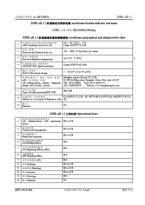
ZSPD AD 2.1 机场地名代码和名称 Aerodrome location indicator and nameZSPD-上海/浦东 SHANGHAI/PudongZSPD AD 2.2 机场地理位置和管理资料 Aerodrome geographical and administrative dataZSPD AD 2.3 工作时间 Operational hours1机场基准点坐标及其在机场的位置ARP coordinates and site at AD N31°08.7' E121°47.6'Center of RWY17L/35R2方向、距离Direction and distance from city 108° GEO, 32.3km from city center 3标高/参考气温Elevation/Reference temperature 4m/ 32.6°C (JUL)4机场标高位置/高程异常AD ELEV PSN/ geoid undulation Center of RWY16L/34R/-5磁差/年变率MAG V AR/Annual change5° W(1977)/ 0'42''W (1970)6机场管理部门、地址、电话、传真、AFS 、电子邮箱、网址AD administration, address, telephone,telefax, AFS, E-mail, website Shanghai Airport (Group) CO. LTD.Nr. 900 Qi Hang street, Shanghai, China. Post code: 201207TEL: 86-21-96990 FAX: 86-21-68342735AFS: ZSPDYDYX Website: 7允许飞行种类Types of traffic permitted(IFR/VFR)IFR/VFR8机场性质/飞行区指标Military or civil airport & Reference code Civil/(RWY17L/35R: 4E; RWY16R/34L,RWY16L/34R,RWY17R/35L:4F)9备注RemarksNil1机场当局(机场开放时间)AD Administration (AD operational hours)HS or O/R 2海关和移民Customs and immigration HS or O/R 3卫生健康部门Health and sanitation HS or O/R 4航行情报服务讲解室AIS Briefing Office H245空中交通服务报告室ATS Reporting Office (ARO)H246气象讲解室MET Briefing Office H247空中交通服务 ATS H248加油 Fuelling HS or O/R 9地勤服务 Handling HS or O/R 10保安 Security HS or O/R 11除冰 De-icing H2412备注 RemarksNilZSPD AD 2.4 地勤服务和设施 Handling services and facilitiesZSPD AD 2.5 旅客设施 Passenger facilitiesZSPD AD 2.6 援救与消防服务 Rescue and fire fighting services1货物装卸设施Cargo-handling facilities Lift, platform trailer, container trailer, tow-tractor, cargo trailer, container baggage trailer, conveyor truck 2燃油/滑油牌号Fuel/oil typesJet A-1--3加油设施/能力Fuelling facilities/capacity Refueling truck (65000 liters:63 liters/ sec&20000 liters:33 liters/ sec);hydrant dispenser:63 liters/ sec; refueling well: 1000 liters/ sec 4除冰设施De-icing facilities10 de-icers 5过站航空器机库Hangar space for visiting aircraft Available6过站航空器的维修设施Repair facilities for visiting aircraft Periodic detection available for various types of aircraft on request.Engine and other aircraft component changement available for part of aircraft.7备注RemarksAir preconditioning unit, oxygen filling vehicle, plane traction rod(for B737-A380), potable water vehicle, sewage disposal vehicle, garbage truck, ferry vehicle, the disabled lift car, no power source car, forklift1宾馆Hotels At AD and in the city 2餐馆Restaurants At AD3交通工具Transportation Passenger's coaches, taxis, magnetic aero train 4医疗设施Medical facilities First-aid, 6 ambulances and medical center at AD 5银行和邮局Bank and Post Office At AD6旅行社Tourist Office At ADTEL: 86-21-683464527备注RemarksNil1机场消防等级AD category for fire fighting CAT 102援救设备Rescue equipmentFire fighting facilities: rapid intervention vehicle, foam tender, dry-chemical tender, disassembly rescue truck, lift rescue truck, illumination truck, command car, logistics car.Rescue equipment: uplift air cushion, mobile surface operation devices,damaged aircraft, fork, air compressor, tethered hoisting equipment.3搬移受损航空器的能力Capability for removal of disabled aircraft MTWA up to A3804备注RemarksNilZSPD AD 2.7 可用季节-扫雪 Seasonal availability-clearingZSPD AD 2.8 停机坪、滑行道及校正位置数据 Aprons, taxiways and check locations data1扫雪设备类型Types of clearing equipment All seasonsSnow blowers, snow fluid truck, snow pusher2扫雪顺序Clearance priorities RWY17L/35R, rapid exit (RWY17L/35R), TWY (FM deicing stands to RWY17L/35R), other RWYs, TWY , apron 3备注RemarksNil1停机坪道面和强度Apron surface and strengthSurface:Cement concreteStrength:Apron Nr.1: PCN 121/R/B/W/T: 6-24 (13 absent); PCN 89/R/B/W/T: 1-5, 25-29Apron Nr.2: PCN 121/R/B/W/TApron Nr.3(cargo): PCN 107/R/B/W/TApron Nr.4: PCN 75/R/B/W/T: 401A, 401B, 402A, 402B,403-418; PCN 68/R/B/W/T: 458-459; PCN 60/R/B/W/T:451-453Apron Nr.5: PCN 121/R/B/W/T: 502-512, 532-543; PCN 79/R/B/W/T: 562-575Apron Nr.6(cargo): PCN 115/R/B/W/T: 625, 626; PCN 109/R/B/W/T: 611-620Apron Nr.7: PCN 106/R/B/W/T: north of Terminal 2 (57-91); PCN 85/R/B/W/T: othersApron Nr.8: PCN 106/R/B/W/T: 806-816; PCN 85/R/B/W/T: 801-805Apron 3W(cargo): PCN 104/R/B/W/T2滑行道宽度、道面和强度Taxiway width, surface and strength Width:23 m: W4-W6;25m or wider for other TWYsSurface:Asphalt concrete: P2-P6(BTN TWY A & RWY17L/35R);P2-P6(BTN TWY D & RWY17L/35R); R2,R5(BTN TWYG & RWY16R/34L); R3-R4(BTN TWY F & RWY16R/34L); G(N of rapid exit TWY G6, S of rapid exit TWYG1);Cement concrete: othersStrength:PCN 126/F/C/W/T:TWYs BTN D&RWY17L/35R:P1-P6;PCN 121/R/B/W/T: A, B, B1-B8, P1-P6(E of RWY17L/35R);PCN 117/R/B/W/T: E5-E7(W of TWY E), W6-W7(N ofTWY T4), R5-R6(W of TWY E);PCN 112/F/C/W/T:TWYs BTN G & RWY16R/34L: R2-R5;TWYs BTN F & RWY16R/34L: R3-R4, G(N of rapid exitTWY G6, S of rapid exit TWY G1);PCN 109/R/B/W/T: E, E1-E2, F, R1-R2, R5-R6(east ofTWY E),E5-E7(east of TWY E), T3, T4, W1, W3, W4-W7(S ofTWY T4);PCN 104/R/B/W/T: C, D, H, G(BTN TWY G1 & TWYG6), T5, T6, S1;TWYs BTN C & apron 3W:Q1-Q6, P1-P2, P4, P6;TWYs BTN C & RWY17R/35L: P1-P2, P4, P6, Q1, Q6;TWYs BTN D & RWY17R/35L: P1-P2, P4, P6;TWYs BTN G & RWY16L/34R: R1, R2, R5, R6;TWYs BTN H & RWY16L/34R: R1, R2, R5, R6, J1, J2;PCN 85/R/B/W/T: W4-W5(N of TWY T4);PCN 84/R/B/W/T:TWYs BTN C&RWY17R/35L:C1-C2, C5-C6;TWYs BTN D&RWY17R/35L:D1-D2, D5-D6;PCN 79/R/B/W/T: R3-R4, E3-E4, F1-F4;PCN 75/R/B/W/T: rapid exit TWY A1-A6PCN 74/R/B/W/T: rapid exit TWY G1-G6, H1-H6;PCN 66/R/B/W/T:TWYs BTN C&RWY17R/35L:C3-C4;TWYs BTN D&RWY17R/35L:D3-D4;3高度表校正点的位置及其标高ACL location and elevationNil4VOR/INS校正点VOR/INS checkpointsNil 5备注 Remarks NilZSPD AD 2.9 地面活动引导和管制系统与标识Surface movement guidance and control system and markingsZSPD AD 2.10 机场障碍物 Aerodrome obstacles1航空器机位号码标记牌、滑行道引导线、航空器目视停靠/停放位置引导系统的使用Use of aircraft stand ID signs, TWY guide lines and visual docking/parking guidance system of aircraft standsTaxiing guidance signs at all intersections of TWY and RWY and at all holding positions.Taxing centerlines or guide lines at all TWYs and aprons.Nose-in guidance for aircraft stands.Visual docking Guidance System for all aircraft stands at aprons Nr.1 and Nr.7, others available for marshaller guidance.2跑道和滑行道标志及灯光RWY and TWY marking and LGTRWY markingsTHR, RWY designation, TDZ, center circle, center line, edge line, aiming pointRWY lightsCenter line, edge line, THR, RWY end,TDZ(RWY16L/34R&RWY17R/35L exclusive), wing barTWY markingsCenter line, RWY holding positions, edge line,intermediate holding position, TWY shoulder, no entering marking, information sign, mandatory instruction signTWY lightsCenter line, edge line, intermediate holding position,RWY guard lights, rapid exit TWY indicator.3停止排灯Stop barsRWY17L/35R: E of RWY: P1-P2, B1, P4, P6, B7, B8, rapid exit TWY A1-A6; W of RWY: P1-P6;RWY16L/34R: R2-R5 at cross RWY16R/34L,G1-G6, H1-H6RWY16R/34L: R1-R2, E1, E5, F1-F4, R5-R6RWY17R/35L: rapid exit TWY C1-C6, D1-D64备注RemarksNilObstacles within a circle with a radius of 15km centered on RWY 17L/35R center 序号Serial Nr.障碍物类型(*代表有灯光)Obstacle type (*Lighted)磁方位BRG (MAG)(degree)距离DIST(m)海拔高度Elevation (m)影响的飞行程序及起飞航径区Flight procedure/take-off flightpath area affected1*BLDG 009238554.02Pole 010218740.53*BLDG 012212951.54*Antenna061248518.4RWY16R/ ILS/DME final approach5*Antenna 062266117.4RWY16L/ ILS/DME final approach6*Control TWR099935106.3CAT A/B/C Circling Sector 7*Antenna 10768348.88*Antenna121358417.5RWY34R/ ILS/DME final approach9*Antenna 123344018.5RWY34L/ ILS/DME final approach 10TWR 146550833.1Take-off path 11Lighting Rod 147585740.1Take-off path12Lighting Rod148610528.913TWR 1531320633.414Lighting Rod 1541294928.915*TWR 158835150.216*TWR 158856243.717*TWR1661326947.018*TWR 1671487660.7RWY35R/ GP INOP final approachRWY35R/ VOR/DME final approach19Lighting Rod 1671326239.320*Antenna 171169118.1RWY35R/ ILS/DME final approach21TWR 1711184149.022*Antenna 178171318.6RWY35L/ ILS/DME final approach23Lighting Rod 1791120835.324*TWR182572548.7Obstacles within a circle with a radius of 15km centered on RWY 17L/35R center 序号Serial Nr.障碍物类型(*代表有灯光)Obstacle type (*Lighted)磁方位BRG (MAG)(degree)距离DIST(m)海拔高度Elevation (m)影响的飞行程序及起飞航径区Flight procedure/take-off flightpath area affected25*BLDG 20410153149.9RWY34L/R/ Initial approach RWY35L/R/ Initial approach RWY17L/R/ Departure CAT D Circling26*TV TWR 20910842108.127Lighting Rod 220699158.528Chimney 231562865.629*TWR 242468547.830*TWR 242445952.631*Antenna 279447023.732*Antenna 288365250.733TWR 289481047.934*Antenna 296388046.535*Antenna 3081091998.836*Antenna 330115418.6RWY17R/ ILS/DME final approach37*TWR 333921643.738Antenna 3331273859.039*TWR 337563429.740Antenna3381004732.841*TWR 3401117750.3RWY17L/ GP INOP final approachRWY17L/ VOR/DME final approach42BLDG 341882454.243*Antenna 343169118.0RWY17L/ ILS/DME final approach44Lighting Rod3431290234.845TWR346795239.3Obstacles within a circle with a radius of 15km centered on RWY 17L/35R center 序号Serial Nr.障碍物类型(*代表有灯光)Obstacle type (*Lighted)磁方位BRG (MAG)(degree)距离DIST(m)海拔高度Elevation (m)影响的飞行程序及起飞航径区Flight procedure/take-off flightpath area affected46*Antenna355377447.9RWY35L/R/ DepartureObstacles between two circles with the radius of 15km and 50km centered on the RWY17L/35R center 序号Serial Nr.障碍物类型(*代表有灯光)Obstacle type (*Lighted)磁方位BRG(MAG)(degree)距离DIST(m)海拔高度Elevation (m)影响的飞行程序及起飞航径区Flight procedure/take-off flightpath area affected1Chimney15516228502TWR 1551696593RWY34L/R/ Intermediate approachRWY35L/R/ Intermediate approachRWY16L/R/ Departure 3*Chimney 260324122154*Lighting Rod 273316012225*Lighting Rod 290284641566*BLDG 292340522847BLDG 29529632632Sector8*Lighting Rod297296024239*Pole 2973033346610*BLDG 2972942049411*Lighting Rod3042729923012*Chimney 32830037245RWY16L/R/ Initial approach RWY17L/R/ Initial approach 13*Wind indicator35832282216Remark: Other obstacles refer to AD OBST chart.Obstacles within a circle with a radius of 15km centered on RWY 17L/35R center 序号Serial Nr.障碍物类型(*代表有灯光)Obstacle type (*Lighted)磁方位BRG (MAG)(degree)距离DIST(m)海拔高度Elevation (m)影响的飞行程序及起飞航径区Flight procedure/take-off flightpath area affectedZSPD AD 2.11 提供的气象信息、机场观测与报告Meteorological information provided & aerodrome observations and reports 1相关气象室的名称Associated MET Office Shanghai Pudong Aerodrome MET Office2气象服务时间、服务时间以外的责任气象室Hours of service, MET Office outsidehoursH24--3负责编发TAF的办公室;有效期Office responsible for TAF preparation,Periods of validityShanghai Pudong Aerodrome MET Office9 HR, 24 HR4着陆预报类型、发布间隔Type of landing forecast, Interval ofissuanceTrend30 MIN5所提供的讲解/咨询服务Briefing/consultation provided P, T6飞行文件及其使用语言Flight documentation, Languages used Chart, International MET Codes, Abbreviated Plain Language Text Ch, En7讲解/咨询服务时可利用的图表和其它信息Charts and other information availablefor briefing or consultationSynoptic charts, real-time data, forecast, satellite and radar material, dataforecast product8提供信息的辅助设备Supplementary equipment available forproviding informationFAX, MET Service Terminal9接收气象信息的空中交通服务单位ATS units provided with information Pudong Tower, Shanghai Approach, shanghai ACC10观测类型与频率/自动观测设备Type & frequency of observation/Automatic observation equipmentHalf hourly plus special observation/Yes11气象报告类型及所包含的补充资料Type of MET Report & supplementaryinformation includedMETAR, SPECI, TEND12观测系统及位置Observation System & Site(s)SFC wind sensors: RWY16R: 127m E of RCL, 331m inward THR; RWY34L: 127m E of RCL, 331m inward THR; RWY16L 110m W of RCL, 343m inward THR; RWY34R 110m W of RCL, 343m inward THR; center: RWY34R 125m W of RCL, 1905m inward THR;RWY17L: 120m W of RCL, 330m inward THR; RWY35R: 120m W of RCL, 330m inward THR; RWY17R: 107m E of RCL, 325m inward THR; RWY35L: 107m E of RCL, 325m inward THR.RVR EQPT: A:100m W of RWY16L/34R RCL, 323m inward THR16L; B:125m W of RWY16L/34R RCL, 1895m inward THR34R; C: 100m W of RWY16L/34R RCL, 333m inward THR34R; D: 120m E of RWY16R/ 34L RCL, 367m inward THR16R;E: 120m E of RWY16R/34L RCL, 1900m inward THR34L; F:120m E of RWY16R/34L RCL, 317m inward THR34L; G: 120m W of RWY17L/35R RCL, 330m inward THR17L; H: 120m W of RWY17L/35R RCL, 2000m inward THR35R; J: 120m W of RWY17L/35R RCL, 330m inward THR35R; K: 100m E of RWY17R/ 35L RCL, 340m inward THR17R; L: 100m E of RWY17R/35L RCL, 1660m inward THR 35L; M: 100m E of RWY17R/35L RCL, 310m inward THR35L;Ceilometer: Near MM for RWY16R/34L, 17L/35R; RWY17R: 70m W of RCL, 279m inward THR; RWY 35L: 70m W of RCL, 279m inward THR; RWY16L: 8m E of RCL, 905m inward THR; RWY 34R: 8m E of RCL, 905m inward THR.13气象观测系统的工作时间Hours of operation for meteorological observation systemH2414气候资料Climatological information Climatological tables A VBL15其他信息Additional information NilZSPD AD 2.12 跑道物理特征 Runway physical characteristics跑道号码Designations RWY NR真方位和磁方位TRUE &MAG BRG跑道长宽Dimensions ofRWY(m)跑道强度(PCN),跑道道面/停止道道面RWY strength (PCN),RWY surface/SWYsurface着陆入口坐标及高程异常THR coordinatesand geoidundulation跑道着陆入口标高,精密进近跑道接地地带最高标高THR elevation andhighest elevation ofTDZ of precisionAPP RWY12345617R162° GEO167° MAG 3400×60104/R/B/W/T (end)84/R/B/W/T (middle)Cement concreteNilTHR 3.6m--35L342° GEO347° MAG 3400×60104/R/B/W/T (end)84/R/B/W/T (middle)Cement concreteNilTHR 3.6m--17L162° GEO167° MAG 4000×60121/R/B/W/TCement concreteNilTHR 3.0m--35R342° GEO347° MAG 4000×60121/R/B/W/TCement concreteNilTHR 3.1m--16R162° GEO167° MAG 3800×60109/R/B/W/T (end)88/R/B/W/T (middle)Cement concreteNilTHR 3.4m--34L342° GEO347° MAG 3800×60109/R/B/W/T (end)88/R/B/W/T (middle)Cement concreteNilTHR 3.5m--16L162° GEO167° MAG 3800×60104/R/B/W/T (end)83/R/B/W/T (middle)Cement concreteNilTHR 3.6m--34R342° GEO347° MAG 3800×60104/R/B/W/T (end)83/R/B/W/T (middle)Cement concreteNilTHR 3.6m--跑道-停止道坡度Slope ofRWY-SWY 停止道长宽SWYdimensions(m)净空道长宽CWY dimensions(m)升降带长宽Strip dimensions (m)无障碍物地带OFZ跑道端安全区长宽RWY end safetyarea dimensions(m)7891011120.0%Nil Nil3520×300Nil230×150m0.0%Nil Nil3520×300Nil230×150m See AOC Nil Nil4120×300Nil235×150m See AOC Nil Nil4120×300Nil235×150m See AOC Nil Nil3920×300Nil235×150m See AOC Nil Nil3920×300Nil235×150m See AOC Nil Nil3920×300Nil240×150m See AOC Nil Nil3920×300Nil240×150m Remarks:1. Distance between RCL of RWY16R/34L and RCL of RWY17L/35R is 2260m; RWY16R THR is 1000m south of RWY17L THR; RWY34L THR is 800m south of RWY35R THR; Distance between RCL of RWY17R/35L and RCL of RWY17L/35R is 460m; RWY17R THR is 600m south of RWY17L THR. Distance between RCL of RWY16L/34R and RCL of RWY16R/34L is 440m;2. RWYs grooved at full length, width 60m.ZSPD AD 2.13 公布距离 Declared distances跑道代号RWY Designator 可用起飞滑跑距离TORA(m)可用起飞距离TODA(m)可用加速停止距离ASDA(m)可用着陆距离LDA(m)备注Remarks12345 6 17R3400340034003400Nil17R3200320032003400FM Q6 35L3400340034003400Nil35L3200320032003400FM Q1 17L4000400040004000Nil17L3780378037804000FM B7 35R4000400040004000Nil35R3780378037804000FM B1 16R3800380038003800Nil16R3700370037003800FM E5 16R3320332033203800FM R5 34L3800380038003800Nil34L3700370037003800FM E1 34L3230323032303800FM R2 16L3800380038003800Nil16L3700370037003800FM J2 16L3262.53262.53262.53800FM R5 34R3800380038003800Nil34R3700370037003800FM J1 34R3176317631763800FM R2ZSPD AD 2.14 进近和跑道灯光 Approach and runway lightingZSPD AD 2.15 其它灯光,备份电源 Other lighting, secondary power supply跑道代号RWY Desig -nator进近灯类型、长度、强度APCH LGT type LEN INTST 入口灯颜色、翼排灯THR LGT colour WBAR 目视进近坡度指示系统(跑道入口最低眼高),精密进近航道指示器V ASIS (MEHT) PAPI接地地带灯长度TDZ LGT LEN跑道中心线灯长度、间隔、颜色、强度RWY Center line LGT LEN, spacing, colour, INTST跑道边灯长度、间隔、颜色、强度RWY edge LGT LEN, spacing, colour, INTST跑道末端灯颜色RWY end LGT colour停止道灯长度、颜色SWY LGT LEN, colour12345678917R/ 35L CAT I 900m*VRB LIH Green Yes PAPI Left/3°Nil3400m******spacing 30m3400m*******spacing 60m RedNil17L/ 35R CAT II 900m*VRB LIH Green Yes PAPI Left/3°900m4000m**spacing 15m4000m***spacing 60m Red Nil16R/34L CAT II 900m*VRB LIH Green Yes PAPI Left/3°900m3800m****spacing 15m3800m*****spacing 60m Red Nil16L/34RCAT I 900m*VRB LIHGreen YesPAPI Left/3°NIL3800m****spacing 15m3800m*****spacing 60mRed NilRemarks: *SFL** up to 3100m White VRB LIH; 3100-3700m Red/White VRB LIH; 3700-4000 Red VRB LIH *** up to 3400m White VRB LIH; 3400-4000m Yellow VRB LIH**** up to 2900m White VRB LIH; 2900-3500m Red/White VRB LIH; 3500-3800 Red VRB LIH ***** up to 3200m White VRB LIH; 3200-3800m Yellow VRB LIH******up to 2500m White VRB LIH; 2500-3100m Red/White VRB LIH; 3100-3400m Red VRB LIH *******up to 2800m White VRB LIH; 2800-3400m Yellow VRB LIH1机场灯标/识别灯标位置、特性和工作时间ABN/IBN location, characteristics and hours of operationNil2着陆方向指示器位置和灯光;风速表位置和灯光LDI location and LGT, Anemometer location and LGTNil3滑行道边灯和中心线灯光TWY edge and center line lighting TWY center line lights available for all TWYs;Blue TWY edge line lights available for all TWYS;TWY edge reflector sticks available for straight TWY of 16R-34L, T3, T4.4备份电源/转换时间Secondary power supply/switch-over time Standby power supply available/ 1 sec for RWY 17L/35R and 16R/34L; 15 sec for all RWYs.5备注RemarksRed OBST LGT for all LGT stationsZSPD AD 2.16 直升机着陆区域 Helicopter landing areaZSPD AD 2.17 空中交通服务空域 ATS airspace1TLOF 坐标或FATO 入口坐标及高程异常Coordinates TLOF or THR of FATO Geoid undulationNil2TLOF 和/或FATO 标高 (m)TLOF and/or FATO elevation (m)Nil3TLOF 和FATO 区域范围、道面、强度和标志TLOF and FATO area dimensions, surface, strength, marking Nil4FATO 的真方位和磁方位True and MAG BRG of FATO Nil 5公布距离Declared distance available Nil 6进近灯光和FATO 灯光APP and FATO lighting Nil 7备注RemarksNil名称Designation 横向界限Lateral limits垂直界限Vertical limits备注RemarksShanghai/Pudong towercontrol areaBy ATCSFC-600m MSLFuel Dumping Area N3113.0E12300.0-N3130.0E12400.0-N3110.0E12400.0-N3100.0E12300.0-N3113.0E12300.03000m and aboveSee Fuel Dumping Area ChartAltimeter setting region andTL/TASASAN-PIKAS-Nantong VOR-BUNV A-UDOXI-IBEGI-N314611 E1224630 - EMSAN - DUMET - N311241 E1224630 -BONGI - PONAB - RUXIL - N301500 E1221200 - Andong VOR-Nanxun VOR-SASANTL 3600m TA 3000m3300m(QNH ≥1031hPa) 2700m(QNH ≤979hPa)ZSPD AD 2.18 空中交通服务通信设施 ATS communication facilities服务名称Service Designation呼号Call sign频率Frequency (MHz)工作时间Hours of operation备注Remarks12345ATIS127.85H24D-ATIS availableAPP (ZSSS)ShanghaiApproach120.30(119.75) ZSSS AP01H24NilAPP (ZSSS)ShanghaiApproach125.40(119.75) ZSSS AP02H24NilAPP (ZSSS)ShanghaiApproach125.85(119.2) ZSSS AP03125.40(119.75)0001-14001401-2400NilAPP (ZSSS)ShanghaiApproach123.80(119.2) ZSSS AP040030-1430NilAPP (ZSSS)ShanghaiApproach126.65(128.05) ZSSS AP05120.30(119.75)0030-14301431-0029NilAPP (ZSSS)ShanghaiApproach126.3(120.65) ZSSS AP060030-1430NilAPP (ZSSS)ShanghaiApproach121.10(124.05) ZSSS AP07120.30(119.75)0030-14301431-0029NilAPP (ZSSS)ShanghaiApproach127.75(124.05) ZSSS AP08125.40(119.75)0030-14301431-0029NilTWR Pudong Tower118.8(118.325) TWR01H24For RWY17L/35RTWR Pudong Tower118.4(118.725) TWR02H24For RWY16L/ 34R&16R/34LTWR Pudong Tower124.35(118.325) TWR03H24For RWY17R/35LTWR Pudong Tower118.575(118.725)TWR04H24For RWY16L/34RGND Pudong Ground121.8(121.7) for east sector H24Nil GND Pudong Ground121.65 (121.7) for west sector H24Nil GND Pudong Delivery121.95(121.7)H24DCL available EMG121.50H24NilZSPD AD 2.19 无线电导航和着陆设施 Radio navigation and landing aids设施名称和类型Name and type ofaid 识别ID频率Frequency发射天线位置、坐标Antenna sitecoordinatesDME发射天线标高Elevation ofDMEtransmittingantenna备注Remarks123 45 6Hengsha VOR/DME HSH114.4 MHzCH91XN31° 22.1'E121° 50.8'Liuzao VOR/DME PDL109.4 MHzCH31XN31° 07.8'E121° 40.3'4.1mPudong VOR/DME PUD116.9 MHzCH116XN31° 10.3'E121° 47.0'347° MAG/1090m FMTHR RWY 17LShuyuan VOR/DME XSY112.7 MHzCH74XN30° 55.9'E121° 52.4'27m167° MAG/22636m FMTHR RWY 35RMM 16R75 MHz 347° MAG/ 1050m FM THR RWY 16RIM 16R75 MHz 347° MAG/ 350m FM THR RWY 16RLOC 16R ILS CAT I IZZ108.7 MHz167° MAG/288m FM endRWY 16RGP 16R330.5 MHz 130m E of RCL317m FM THR16RAngle 3°RDH 15mDME IZZ CH24X(108.7MHz) 3.8m Co-located with GPLOC 16L ILS CAT I IHL111.5 MHz167° MAG/315m FM endRWY 16LGP 16L332.9 MHz 120m W of RCL 313m FM THR 16LDME IHL CH52X 6.4m Co-located with GPMM 34L75 MHz 167° MAG/ 1050m FM THR RWY 34LIM 34L75 MHz 167° MAG/ 350m FM THR RWY 34LLOC 34L ILS CAT I IDD108.3 MHz347° MAG/288m FM endRWY 34LGP 34L334.1 MHz 130m E of RCL317m inwardTHR 34LAngle 3°RDH 15mDME IDD CH20X(108.3MHz) 3.8m Co-located with GPLOC 34R ILS CAT I IPR108.9 MHz347° MAG/315m FM endRWY 34RGP 34R329.3 MHz 120m W of RCL 313m inward THR 34RDME IPR CH26X(108.9MHz) 6.5m Co-located with GPMM 17L75 MHz 347° MAG/ 1070m FM THR RWY 17LIM 17L75 MHz 347° MAG/ 313m FM THR RWY 17LLOC 17L ILS CAT II IPD110.7MHz167° MAG/295m FM endRWY 17LGP 17L330.2 MHz 130m W of RCL314m inwardTHR 17LAngle 3°RDH 15mDME IPD CH44X(110.7 MHz)8m Co-located with GPOM 35R75 MHz 167° MAG/ 8982m FM THR RWY 35RMM 35R75 MHz 167° MAG/ 1030m FM THR RWY 35RIM 35R75 MHz 167° MAG/ 313m FM THR RWY 35RLOC 35R ILS CAT II INN111.9 MHz347° MAG/295m FM endRWY 35RGP 35R331.1 MHz 130m W of RCL314m inwardTHR 35RAngle 3°RDH 15m设施名称和类型Name and type ofaid 识别ID频率Frequency发射天线位置、坐标Antenna sitecoordinatesDME发射天线标高Elevation ofDMEtransmittingantenna备注RemarksLOC 35L ILS CAT IIBD 108.1MHz347° MAG/ 285m FM end RWY 35L GP 35L 334.7MHz 120m E of RCL 310m inward THR 35LAngle 3°RDH 15mDME IBDCH18X (108.1MHz)11.3mCo-located with GPLOC 17R ILS CAT IIKM111.1MHz167° MAG/ 285m FM end RWY 17R GP 17R 331.7MHz 120m E of RCL 310m inward THR 17RAngle 3°RDH 15mDME IKMCH48X (111.1MHz)11.3mCo-located with GPRemark: NilZSPD AD 2.20 本场飞行规定ZSPD AD 2.20 Local traffic regulations1. 机场使用规定1. Airport operations regulations1.1禁止未安装二次雷达应答机的航空器起降;1.1 Takeoff/landing of aircraft without SSR transponder are forbidden;1.2所有技术试飞需事先申请,并在得到空中交通管制部门批准后方可进行; 1.2 Each and every technical test flight shall be filed inadvance and shall be made only after clearance has beenobtained from ATC;1.3可使用最大机型:A380及同类机型。
国际通程航班解读
国际通程航班解读
航班号:XXXXX
出发地:(城市)-(机场码)
目的地:(城市)-(机场码)
航线距离:XXXX km
预计飞行时间:XX小时XX分钟
计划起飞时间:(时间)
计划到达时间:(时间)
1. 航班号:每个航班都由唯一的航班号识别,用于方便航空公司和旅客的管理。
2. 出发地和目的地:标识了航班的起点和终点位置,以城市和机场码的形式表示。
通常,城市由三个字母的IATA代码表示,如"JFK"代表纽约肯尼迪机场。
3. 航线距离:表示起点和终点之间的直线距离,以千米为单位。
这个距离通常是通
过大圆航线计算得出的,以最短路径连接起点和终点。
4. 预计飞行时间:航班的预计飞行时间是根据航线距离和飞行速度计算得出的。
这
个时间并不包括起飞和降落的时间,而是指在空中飞行的时间。
5. 计划起飞时间和计划到达时间:这是航班的预计起飞和预计到达时间。
这些时间
是根据航班计划和预计飞行时间计算得出的,不包括任何延误或提前到达的情况。
除了这些基本信息,通常还会包括其他重要的航班详情,如预计登机时间、航班状态、出发门和到达门等。
旅客可以根据这些信息合理安排自己的行程,以确保顺利抵达目的
地。
需要注意的是,航班信息可能会有变动或更新,因此建议旅客在出行前确认最新的航
班信息以免带来不便。
最快捷的方式是通过航空公司官方网站、手机应用或联系客服进行
查询。
海浦东机场ZSPD
35L
LAMEN
LAM12D.35R
35R
LAMEN
LAM21D
16
LAMEN
LAM22D
34
LAMEN
ODU11D.17L
17L
ODULO
ODU11D.17R
17R
ODULO
ODU12D.35L
35L
ODULO
ODU12D.35R
35R
ODULO
ODU13D.17L
17L
ODULO
PIK21D
16
PIKAS
PIK22D
34
PIKAS
PIK23D
16
PIKAS
PIK24D
34
PIKAS
PIK25D
16
PIKAS
SHA12D.34
34
SHA
SHA12D.35L
35L
SHA
SHA12D.35R
35R
SHA
SX11D.17L
17L
SX
SX11D.17R
17R
SX
SX12D.35L
35L
沥青
IJOC 109.50
27
有
13L
133
9992ft(3045m)
150ft(45m)
沥青
111.50 ITLK
27
有
31R
313
9992ft(3045m)
150ft(45m)
沥青
IRTH 111.50
27
有
04R
043
8401ft(2560m)
27
无
17
167
13123ft(3999m)
浦东机场经过临港新城的航班261个
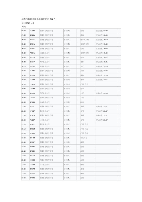
发出合计118
国内
07:35
CA1893
中国国际航空公司
浦东(T2)
深圳
实际出发07:50
07:55
MU5201
中国东方航空公司
浦东(T1)
珠海
实际出发08:00
19:05
MU5371
中国东方航空公司
浦东(T1)
张家界大庸
实际出发19:19
19:20
MU9341
中国东方航空公司
中国东方航空公司
浦东(T1)
深圳
21:30
MU1354
中国东方航空公司
浦东(T1)
长沙市
21:30
MU1352
中国东方航空公司
浦东(T1)
长沙市
21:30
MU1320
中国东方航空公司
浦东(T1)
长沙市
21:30
MU1338
中国东方航空公司
浦东(T1)
长沙市
21:30
MU1386
中国东方航空公司
浦东(T1)
MU7554
中国东方航空公司
浦东(T1)
深圳
21:20
MU7220
中国东方航空公司
浦东(T1)
深圳
21:20
DL7036
美国达美航空公司
浦东(T1)
深圳
21:20
JL5755
日本航空公司
浦东(T1)
深圳
21:20
MU5675
中国东方航空公司
浦东(T1)
厦门
21:20
MU7582
中国东方航空公司
浦东(T1)
22:35
浦东国际机场英语介绍
浦东国际机场英语介绍Pudong International Airport (IATA: PVG, ICAO: ZSPD) is located in Pudong New Area of Shanghai, China, and is the main international airport serving Shanghai and the surrounding areas. It was officially opened on the morning of October 1, 1999, and is currently the second busiest airport in China after Beijing Capital International Airport, with a passenger traffic volume of over 100 million passengers per year.The airport is connected to the Shanghai Metro network, with access to various parts of the city. The Pudong International Airport T erminal 1 Station is served by Lines 2, 5, 7, 8 and 10 of the Shanghai Metro, and the Pudong International Airport Terminal 2 Station is served by Lines 2, 5 and 10. In addition, there are also airport buses connecting the airport to various parts of the city.Pudong International Airport plays an important role in China's aviation network, serving as a key hub for both international and domestic flights. It is connected to various cities around the world, with destinations including London, Paris, T okyo, Sydney and more. The airport is also one of the main aviation gateways to Shanghai for business travelers and tourists.The airport complex includes two terminals (Terminal 1 and Terminal 2), with several concourses and over 300 departure and arrival gates. Terminal 1 is mainly used for international flights, while Terminal 2 ismainly used for domestic flights. The airport also features a wide range of facilities, including duty-free shopping, restaurants, cafes, lounges and more.Pudong International Airport has been recognized as one of the most efficient and highly rated airports in the world, offering top-notch services and facilities to passengers. It was awarded the "Best Airport" title for five consecutive years (2016-2020) by Skytrax, a leading international air transport research organization. The airport also features a range of lounges and spa facilities that provide passengers with a relaxing atmosphere before flights.The airport campus also includes the Pudong International Airport Hotel, which is connected to Terminal 1 by a covered walkway and provides accommodation for passengers with long layovers or early flights. Additionally, there are various dining options available on the upper floors of both Terminal 1 and Terminal 2, including local Chinese cuisine, international cuisine, cafes and bars.Pudong International Airport plays a key role in Shanghai's tourism industry and is constantly expanding its facilities to meet growing demand. The airport has recently undergone major expansion and modernization projects to increase capacity and improve services, including the opening of Terminal 3 in 2019 and a new mega-terminal planned for completion in 2023.Overall, Pudong International Airport provides a convenient and efficient travel experience for passengers flying to Shanghai and the surrounding areas. It is an important part of China's aviation network and one of the busiest airports in the world, offering a wide range of flights to various destinations around the globe.。
纽约肯尼迪机场攻略
纽约肯尼迪机场攻略纽约肯尼迪机场(John F. Kennedy International Airport)是美国纽约市最重要的国际机场之一,位于纽约市皇后区,是全美国最繁忙的机场之一。
作为进入纽约的重要门户,纽约肯尼迪机场是许多旅客的第一站。
为了帮助您更好地了解纽约肯尼迪机场,本攻略将为您提供有关机场设施、交通方式、航班信息和周边旅游景点等详细信息。
机场设施纽约肯尼迪机场提供各种便利设施,以满足广大旅客的需求。
1.餐饮和购物:机场内设有各种餐馆、咖啡店和商店,提供各种美食和购物选择,满足你的口腹之欲和购物需求。
2.休息区:机场设有休息区和休息室,提供舒适的座椅和充电设备,供旅客休息和充电使用。
3.免税店:机场免税店提供各种商品,包括时尚服饰、化妆品、电子产品和纽约特色纪念品等,是购买礼物的理想场所。
4.无障碍设施:机场内设有无障碍设施,包括轮椅租赁、便利设施和无障碍通道等,以确保身体有障碍的旅客能够顺利流畅地使用机场。
交通方式到达和离开纽约肯尼迪机场有多种交通方式可供选择。
1.出租车:在机场的出租车站可以轻松搭乘出租车前往目的地。
出租车为最常用的交通方式之一,通常有固定的票价。
2.公共交通:纽约肯尼迪机场连接着纽约市的公共交通网络,包括地铁、巴士和长途巴士等。
乘坐公共交通可以更经济和便捷地到达目的地。
3.私人接送:如果您希望更加舒适和便捷地前往目的地,可以预订私人接送服务,如豪华轿车或出租车服务。
航班信息纽约肯尼迪机场是世界上最繁忙的航空枢纽之一,航班信息非常丰富。
1.航空公司:纽约肯尼迪机场有许多知名航空公司的航班,包括美国航空、达美航空、联合航空等。
不同航空公司提供不同的服务和航班路线,可以根据自己的需求选择适合的航空公司。
2.航班查询:机场内设有航班查询信息屏幕和柜台,您可以随时查询到最新的航班信息,包括航班时间、登机口和延误情况等。
3.候机厅:纽约肯尼迪机场提供舒适的候机厅,配有免费Wi-Fi、充电设施和休息区等,为您提供愉快的候机体验。
上海到伦敦航班汇总
上海到伦敦航班汇总上海到伦敦航班汇总一、转机1. 芬兰航空AY58 + AY833上海浦东机场–赫尔辛基机场,09:20 –14:20 (当地时间),航程10小时。
赫尔辛基机场- 伦敦希斯罗机场,16:00 – 17:10 (当地时间),航程3小时。
欧洲最安全+最准时航空公司,服务中上。
首段航程可体验空客A350大飞机,可托运2个23KG行李。
含税价4-5k。
2. 俄罗斯航空SU209 + SU2578上海浦东机场–莫斯科谢列蔑契娃机场,11:40 –16:05 (当地时间),航程18小时。
莫斯科谢列蔑契娃机场- 伦敦希斯罗机场,10:05 – 12:05 (当地时间),航程4小时。
价格最实惠的转机选择,服务一般。
转机要过夜。
可托运2个23KG 行李。
含税价2-3k。
3. 卡塔尔航空QR871 + QR3上海浦东机场–多哈机场,23:50 – 04:50 (当地时间),航程10小时。
多哈机场- 伦敦希斯罗机场,07:45 – 13:15 (当地时间),航程7.5小时。
两段航程都是大飞机,服务中上。
只有红眼航班。
可托运2个23KG 行李。
含税价3-4k。
4. 法国航空AF8448 + AF3181上海浦东机场–阿姆斯特丹机场,12:15 – 18:10 (当地时间)。
阿姆斯特丹机场- 伦敦城机场,07:00 – 07:10 (当地时间)。
总航程14小时左右。
欧洲最老牌的航空公司之一,服务中等,到达时间比较早。
可托运2个23KG行李。
含税价4k左右。
5. 国泰航空(港龙航空)CX5809 + CX251上海浦东机场–香港机场,20:30 – 23:05 (当地时间)。
香港机场- 伦敦希斯罗机场,23:55 – 05:40 (当地时间)。
总航程16小时左右。
港府最大的航空公司,服务好,到达时间比较早。
可托运2个23KG 行李。
含税价4-5k左右。
二、直飞1. 英国航空BA1168上海浦东机场–伦敦希斯罗机场,07:30 –13:00 (当地时间),航程12.5小时。
国际机场三字代码表

Nagoya Niigata Okayama Okinawa Osaka Padang Palembang Paphos Penang Peshawar Phnom Penh Phuket Puerto Princesa Pusan Riyadh Roxa Sanaa Sandakan Sapporo Selou Semarang Senda Sibu Siem Reap Singapore Solo City Surabaya Surat Thani Tacloban Taegu Tagbilaran Taipei Tashkent Tawau Tehran Telaviv Thiruvananthapura Tiruchirapally Tokyo Trang Tuguegarao Udon Thani Ujung Pandang Vientiane Yangon Yogyakarta Zamboanga Aalborg ABERDEEN Adana Ajaccio
广岛 胡志明市 香港 海得拉巴 伊洛伊洛 怡保 伊斯兰堡 雅加达 吉达 新山 鹿儿岛 卡里波 高雄 卡拉齐 卡拉干达 加德满都 孔敬 苏梅岛 小松 哥打巴鲁 哥打基纳巴鲁 卡利刻特 甲米 吉隆坡 瓜拉丁加奴 关丹 古晋(沙捞越) 科威特 光州 纳闽 拿笃 拉合尔 兰卡威 佬沃 拉纳卡 黎牙实比 琅勃拉邦 勒克瑙 澳门 马累 万鸦老 马尼拉 马什哈德 马塔兰 松山 棉兰 米里 孟买 马斯喀特 那牙 长崎
德累斯顿 都柏林 杜勃罗夫尼克 杜塞尔多夫 爱丁堡 埃德米特 埃因霍温 俄祖汝穆 法鲁 佛罗伦萨 法兰克福 弗里的希哈芬 福特弯图拉岛 丰沙尔 加济安泰普 格但斯克 日内瓦 热那亚 格拉斯哥 歌德堡 格拉茨 格勒诺布尔 汉堡 汉诺威 赫尔辛基 亨伯赛 伊比萨岛 因斯布卢克 伊斯坦布尔 伊兹密尔 伊兹米尔 约恩苏 卡托维兹 开赛利 喀山 哈巴罗夫斯克 基辅 克拉根福 科尼亚 科西策 克拉科夫
- 1、下载文档前请自行甄别文档内容的完整性,平台不提供额外的编辑、内容补充、找答案等附加服务。
- 2、"仅部分预览"的文档,不可在线预览部分如存在完整性等问题,可反馈申请退款(可完整预览的文档不适用该条件!)。
- 3、如文档侵犯您的权益,请联系客服反馈,我们会尽快为您处理(人工客服工作时间:9:00-18:30)。
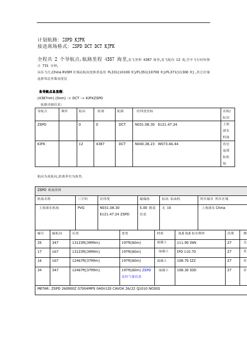
计:划航路:ZSPD KJFK
接进离场格式:ZSPD DCT DCT KJFK
全程共2个导航点,航路里程4387海里,直飞里程4387海里,直飞航向12度,空中飞行时间预计731分钟,
向东飞行,China RVSM 区域巡航高度推荐选用FL331(10100 米)/FL351(10700 米)/FL371(11300 米),其它区域选择邻近单数高度层
各导航点总里程:
ZSPD (0nm) -> DCT -> KJFK (4387nm)
航路详细信息
编号磁航向长度宽度材质ILS标识ILS频率范围测距
35 347 13123ft(3999m) 197ft(60m) 混凝土INN 111.90 27 无
17 167 13123ft(3999m) 197ft(60m) 混凝土IPD 110.70 27
16 167 12467ft(3799m) 197ft(60m) 混凝土IZZ 108.70 27
混凝土108.30 27 有
航向为真航向,距离单位为海里
ZSPD实时气象信息
METAR: ZSPD 260900Z 07004MPS 040V120 CAVOK 26/22 Q1010 NOSIG 机场:ZSPD
日期:26号
时间:09:00 UTC (本地时间:17:00)
地面风:风向070度风速4米每秒
风向变化范围:从040度到120度
【天空状况良好】
温度:26摄氏度
露点:22摄氏度
相对湿度:78.68%
修正海压:1010 毫巴(约29.83 英寸汞柱)。