航海家软件指标说明书
航海家软件基本使用PPT

基本分析平台之版块动向平台
• 高级功能>>版块动向平台: • 他是检测热点版块的指标,我们知道,个股是受大盘影响
图一:
图二:
航海家软件的安装及升级
• 第一次登录软件是需要升级的,因为行情在发展,我们软 件为了适应最新行情也是每一季度都有不同程序的升级。
• 双击软件图标后 ,会自动提示:指标文件不存在,请升级! 点击确定后打开自动升级程序,输入软件帐号和密码后点 击升级即可,如图:
航海家软件的安装及升级
• 升级完成后会自动打开登录界面点,击登录即可,如图: • 注意事项:软件自动登录最好不要选中,因为软件有多
基本指标的讲解
• 捕捞季节:
捕捞季节是表示短线买卖点指 标 ,但K线在智能辅助线下时形成的 金叉为弱势金叉,K线站上智能辅助 线后,回调后在智能辅助线附近时, 捕捞季节产生的金叉为强势 金叉。
死叉的出现,代表风险的加重, 就要及时的控制仓位,可以等回调下 来后再根据软件信号有机会再补回来。
• 主力追踪:
基本指标的讲解
主动性买盘是指以卖出价格 主动成交的成交量,计算入外盘 。外盘就是股票在卖出价成交, 成交价为申卖价,说明买盘比较 积极,推动股价上涨。
• 水手突破:
基本指标的讲解
这是一个非常好的指标,四
条线既能看支撑压力位,同样也 可以做抄底和追涨~在下面的盈利 模式中会讲到。
• 海洋寻底:
基本指标的讲解
的。同样,他也会受到版块的影响。所以,我们能够找到 一个热点版块,在这个版块中选股票,那么成功率就会增 加。但值得注意的是,当行情不是太稳时,我们可以看到 热点轮换比较快,所以我们在操作起来周期也不能放得太 长,捕捞季节出死叉卖出就可以了。 • 重点: • 右上角的版块动力一号(可以点下动力一号,表示的是到 目前为止,此版块的资金流动情况,正的是流入,负的是 流出) • 左下角的排名:他能列出所选 的版块的近20个交易日近20 名的排名情况(横坐标为日期,纵坐标为排名);
常用航海家指标

17、小蛇主力
EMA(HHJ_主力追踪.#选股指标,1)COLORRED;
EMA(HHJ_主力追踪.#选股指标,10)COLORGREEN;
18、小蛇资金
EMA(HHJ_流动资金.活跃度,1)COLORRED;
EMA(HHJ_流动资金.活跃度,10)COLORGREEN;
19、小蛇流动30高
M5:=(MA25-MA60<=0.2 AND MA25-MA60>0) OR (MA60-MA25<=0.2 AND MA60-MA25>0);
M6:=(MA30-MA60<=0.2 AND MA30-MA60>0) OR (MA60-MA30<=0.2 AND MA60-MA30>0);
Q:=MAX(MAX(MA15,MA25),MAX(MA30,MA60));
16、主力追踪五日增加
KP:=HHJ_主力追踪.#选股指标;
A1:=REF(KP,1);
A2:=REF(KP,2);
A3:=REF(KP,3);
A4:=REF(KP,4);
A5:=REF(KP,5);
COUNT(KP>A1,1) and A1>A2 and A2>A3 and A3>A4 and A4>A5;
1、10天多翻红横盘
HH:=hhv(H;
KP:=HHJ_流动资金.活跃度;
AA:=CAPITAL<=10000000;
A1:=REF(KP,1);
A2:=REF(KP,2);
A3:=REF(KP,3);
A4:=REF(KP,4);
A5:=REF(KP,5);
航海家全套指标源码
航海家全套指标源码【航海家证券决策系统公式组全套公式源码】航海家公式组全套公式:1.分时买卖2.水手突破3.主力追踪4.捕捞季节5.海洋寻底6.海洋追涨7.智能辅助18.智能辅助2智能辅助线{主图}HHJSJDA:=(3*CLOSE+OPEN+LOW+HIGH)/6;HHJSJDB:(20*HHJsjda+19*REF(HHJsjda,1)+18*REF(HHJsjda,2 )+17*REF(HHJsjda,3)+16*REF(HHJsjda,4)+15*REF(HHJsjda,5) +14*REF(HHJsjda,6)+13*REF(HHJsjda,7)+12*REF(HHJsjda,8)+11*REF(HHJsjda,9) +10*REF(HHJsjda,10)+9*REF(HHJsjda,11)+8*REF(HHJsjda,12)+7*REF(HHJsjda,13)+6*REF(HHJsjda,14)+5*REF(HHJsjda,15) +4*REF(HHJsjda,16)+3*REF(HHJsjda,17)+2*REF(HHJsjda,18) +REF(HHJsjda,20))/210,coloryellow;HHJSJDC:MA(HHJSJDB,5),colorred;{水手突破}水手突破(抓个股起爆点)水手突破指标:这是一个趋势型指标,在大盘分析处于红色的追涨操作的情况下用该指标选股能选到当时市场中最好的一类股票。
运用原理:当股价进入黄色区域(黄色上方)后,表示该股已经进入黄色的强势区域,可以大胆追涨,也是最好的买点,而当股价进入粉色的区域后股价将加速上扬。
上趋势:MA(LOW,20)*1.2,color0080ff,linethick2;次上趋势:MA(LOW,20)*1.1,COLORYELLOW;次下趋势:MA(HIGH,20)*0.9,COLORWHITE;下趋势:MA(HIGH,20)*0.8,COLORGREEN,linethick2;ZD:=(C-REF(C,1))/REF(C,1)*100;HDZF:=(HHV(H,20)-C)/(HHV(H,20)-LLV(L,20));趋势强度:=IF(C>次上趋势,IF(C>上趋势,4,3),IF(C>次下趋势AND C<</span>次上趋势,2,IF(C<</span>下趋势,0,1)));STICKLINE(趋势强度=0,H,L,6,1),COLORBLUE;STICKLINE(趋势强度=1,H,L,6,1),COLORGREEN; STICKLINE(趋势强度=2,H,L,6,1),COLORGRAY;STICKLINE(趋势强度=3,H,L,6,1),COLORYELLOW; STICKLINE(趋势强度=4,H,L,6,1),COLORMAGENTA; STICKLINE(趋势强度=0,C,O,5,0),COLORBLUE;STICKLINE(趋势强度=1,C,O,5,0),COLORGREEN; STICKLINE(趋势强度=2,C,O,5,0),COLORGRAY;STICKLINE(趋势强度=3,C,O,5,0),COLORYELLOW; STICKLINE(趋势强度=4,C,O,5,0),COLORMAGENTA;代码:{智能辅助线1}{主图}MID:=(3*CLOSE+LOW+OPEN+HIGH)/6;牛线:(20*MID+19*REF(MID,1)+18*REF(MID,2)+17*REF(MID,3)+ 16*REF(MID,4)+15*REF(MID,5)+14*REF(MID,6)+13*REF(MID, 7)+12*REF(MID,8)+11*REF(MID,9)+10*REF(MID,10)+9*REF(MID,11)+8*REF(MID,12)+7*REF(MID,13)+6*REF(MID,14)+5* REF(MID,15)+4*REF(MID,16)+3*REF(MID,17)+2*REF(MID,18) +REF(MID,20))/210,COLORRED;马线:MA(牛线,6),COLORGREEN;五日线:MA(CLOSE,5),POINTDOT,COLORLIBLUE;水平面:MA(CLOSE,60),POINTDOT,COLORYELLOW;代码:{智能辅助2}{主图叠加}HHJSJDA:=(3*CLOSE+OPEN+LOW+HIGH)/6;HHJSJDB:(20*HHJsjda+19*REF(HHJsjda,1)+18*REF(HHJsjda,2 )+17*REF(HHJsjda,3)+16*REF(HHJsjda,4)+15*REF(HHJsjda,5) +14*REF(HHJsjda,6)+13*REF(HHJsjda,7)+12*REF(HHJsjda,8)+11*REF(HHJsjda,9) +10*REF(HHJsjda,10)+9*REF(HHJsjda,11)+8*REF(HHJsjda,12) +7*REF(HHJsjda,13)+6*REF(HHJsjda,14)+5*REF(HHJsjda,15) +4*REF(HHJsjda,16)+3*REF(HHJsjda,17)+2*REF(HHJsjda,18) +REF(HHJsjda,20))/210,coloryellow;HHJSJDC:MA(HHJSJDB,5),colorred;代码:{主力追踪}主力追踪主力追踪(洞察主力意图)主力追踪线:这是一个资金型指标,用于捕捉个股的主力进出情况,紧扣主力操作动向捕捉庄股,在股票市场中股价下跌不一定意味着主力出货,股价上涨也不一定是主力进场,有的时候股价下跌是主力洗盘,有的时候上涨是主力拉高出货,而通过主力追踪线就能更清楚的了解主力的真实意图。
航海家操作手册201(内河)

航海家使用手册
航海家使用手册
一、设备介绍
航海家是一款智能航海设备,可用于导航、气象监测、通信等。
该设备具有高精度GPS、北斗定位系统,可以实时获取船只位置、航向、航速等信息。
同时,航海家还配备了多种传感器,可监测风速、风向、温度、湿度等气象数据,为航海提供全面、准确的信息。
二、操作说明
1. 开机:按下航海家设备上的开机按钮,等待启动完成。
2. 连接:使用USB数据线将航海家与电脑连接,确保设备与电脑正常通讯。
3. 导航:在航海家设备上输入目的地坐标,启动导航模式。
设备将自动规划航线,并提供航行指示。
4. 气象监测:航海家会自动监测当前气象信息,如风速、风向、温度、湿度等。
用户可根据需要查看历史气象数据。
5. 通信:航海家支持Wi-Fi和蓝牙连接,可与手机、电脑等设备进行无线连接,实现实时通讯。
6. 维护:定期对航海家设备进行清洁和维护,确保设备正常运行。
三、注意事项
1. 使用前请仔细阅读说明书,确保正确使用设备。
2. 在使用过程中,请勿将航海家暴露在潮湿、高温等恶劣环境中。
3. 如发现设备故障,请及时联系专业人员进行维修。
4. 在使用航海家进行导航时,请确保目的地的坐标输入正确。
5. 在使用过程中,请勿随意拆卸、改装航海家设备。
iphone-ipad-marine-navigation-app-用户指南说明书

User Guide for iPhone / iPad Marine Navigation AppGeneral App AccessibilityThe app uses standard iOS buttons to traverse through the various screens. Mostscreens also have a home button() on top right. Tapping on it would take you to the homescreen of the app.The map/chart screen includes a menu bar at the bottom. With the chart opened you can access most features from the menu bar. Please tap on the overflow button (thebutton with an uparrow sign ) on the menu bar to view more actions. Some of the most commonly used actions are: (These functions are described in detail later).● New Route: To manually create a new route from scratch.● Route Assistance: To follow a route that you have plotted or imported.● Import Manager: This lets you import routes from existing sources in GPX/KML format. You canalso use this to access created routes or recorded tracks.● Record: This starts track recording. It records the boat location every 3 seconds by default.● Auto Follow: Continuously updates boat's location on the chart.Screenshot showing menu bar and overflow buttonScreenshot showing home buttonFinding Charts to DownloadThe app provides multiple way to download charts:●Visual Search●Chart Catalog●Text SearchVisual SearchUsing visual search you can draw a rectangle around your cruising area and bulk download all charts covering the area. It is accessible via:Add Charts+ -> <Country> -> Visual Search●On the basemap, scroll/zoom to your cruising area. Its better to zoom in closeto your cruising area so that you get results for just that area. Adjust the size of the rectangle by holding and moving the orange dots.● Then tap on “View Overlapping Charts”●You can bulk download charts by tapping on the icon next to “View OverlappingCharts”.The following screenshot illustrates how one can download all charts covering Lake Mead via Visual Search. Lake Mead is covered by 6 charts. One can find them all via Visual search and bulk download them by tapping on download icon on top right.Text SearchYou can also use keywords such as the name of lake or reservoir or other text that identifies the area you are looking for.Its accessible via Add Charts -> <Specific Country> -> Search ChartsFor e.g. if you need coverage for Lake Texoma just typing in Lake Texoma should be sufficient.Chart CatalogWe have also organized the charts covering a region into logical groups/folios that can be accessed under the Chart Catalog.For e.g. there is a separate folio for all charts covering the ‘Trent Severn Waterway’,there is a another for ‘Rideau Canal - Ottawa River’.Route ManagerThis section describes some of the capabilities of the route manager. It is organized into the following sub sections:●Plotting routes manually●Exporting Routes/Tracks (Share via email)●Import Routes (from GPX/KML files)●Enter waypoints manually●FAQs regarding route managerPlotting Routes Manually1.) Open the chart, press overflow button on menu bar and select "New Route".2.) This would show show route editing controls at the top. The route editing controlis initially in pan mode.Tapping on the center button(it looks like two directed route/arrow edges) would switch it to route creationmode.Tap on "New Point" to drop a route point that you would follow in succession.If you want to create a point that is not exactly on route but anavigation aid, use "DropMarker/Pin" (second button from left).3.) When you are done creating the route, tap on "Save Button" to save route. The following screenshot shows Route Editing in action:Hand Icon: Tap on it to switch to pan mode.Pin/Marker Icon: Tap on it to drop a point anywhere (not necessarily on the route).Route Icon: Tap on it to switch to Route mode. In this mode you will see two more buttons on the screen.Save/Disk Icon: Tap on it to save the route.Cancel/End Icon: Tap on it to end your route editing session.Exporting RoutesTo export routes, please follow the following steps:●With the chart opened, press menu/overflow button.●Select Route Manager -> Routes●Tap on the specific routes you wish to export. A check next to the route meansits selected for Export.●Tap on export ButtonThis will open a mail composer with the route exported as a compressed GPX file.Importing RoutesYou can import routes in GPX or KML format from files sent to you via emailattachment. If you know the URL of a file, the app can download the file and import it as well.Importing routes from email attachmentsYou can import routes from GPX and KML files sent to you as an email attachment.●Tap on the attachment●Select “ Open in Gps Nautical Charts”Importing routes from a websiteIf you know the http URL of a rout ein GPX/KML format, you can import it directl in the app using the following:●Select Route Manager -> Import GPX/KML●Enter the URL of GPX/KML fileThe app will automatically download the file and import it in the app.This option is useful if you want to import track available on a third party website.Entering Way PointsThe app allows waypoints to be created in multiple ways. Way Points entered this way are stored under “Default Way Points”.●Using Current Location via GPS●Manually Enter Lat Lon●Way Point under Cursor/Cross Hairs.To create a waypoint this way, please use the following steps:●With the chart opened, press menu/overflow button.●Tap on New WaypointWay Point using Current LocationThis creates a way point at the current location determined using device’s GPS. This can be used to model scenarios such as “Lucky Fishing Spot” or “MOB marker” etc.Way Point By Manually Entering Lat LonIf you know the latitude longitude of a point, you can enter the coordinates manually to create a way point. Please make sure that the coordinate type is set to the format you are going to enter the coordinates in.For e.g. if your coordiantes are in degree minute second format, please make surethat this is what the coordiante type is set to under Options. The app changes the UI depending on the coordinate type. To set coordinate type to your desired format, tap on Options -> Select Coordinate type and tap on “Save”.Way Point under Cross HairsThis lets you create a waypoint under whatever you are seeing under cross hairs of the map at the center. Typically you would use this option as a bookmark for where you were looking at when browsing the chart.Route Manager FAQQ1. I saved a route. How do I edit it later?A1. Please use the following steps to edit a route:●With the chart opened, press menu/overflow button and select Route Manager●Select Routes -> Specific RouteTap on “Edit Route” at the bottom.Q2. How do I change the name of a point on the route or How do I delete a point on the route?A2. By default all created route points have names such as “Marker 1”, “Marker 2” and so on. To change the name of a route point:● Tap on the point,● Tap on button that shows point name “MarkerThis would give you option to change the name or delete the point.Q3. How do I change the name of a default way point or How do I delete a default way point?A3.●With the chart opened, press menu/overflow button and select “View Way Points”●Long touch the point you wish to edit or delete.Auto Follow ModeThis is the simplest form of route assistance. Auto Follow mode (aka the moving map)is accessible by tapping on the “Auto Follow” item on the action bar at the bottom ofthe screen.When turned on it does the following:●Continuously update device’s location on the chart.○This is the standard moving map that shows device’s position on the chart●Real time track overlay of the course you have sailed so far.○This shows the course you have already sailed in dark red/brown color.This gives you an idea of how you got to your current location.●Direction arrow showing a boat’s location if current course is maintained○This is helpful to avoid any sailing hazards esp if you are sailing for fun and not following a pre-defined route.Please note that the last two features listed above are in an update that has not yet been approved.The screenshot below shows these in action.●The yellow icon at the center is boat’s current location.●Dark brown line is the course you’ve taken so far.●The purple arrow shows where you will get if you stay on the current course.Route Assistance With Voice PromptsWhat is route assistance?If you are following a specific route, please use Route Asssistance. A route is essentially a collection of route points that one follows in succession to get from point 'A' to point 'B'. The app automatically figures out what is the next waypoint in the route using current location and heading.With route assistance enabled for a route, the app takes care of the following:●Continuous distance and ETA updates○The app continuously updates distance to the next waypoint on the path.○The top left shows ETA for the entire trip. This is a toggle button. Tappin on this button would toggle between estimated absolute time for thetrip(e.g 2 hr 15 minutes) and the arrival time (e.g. 2:15 PM).●Voice alerts when going off route○The app keeps track of cross track error and issues voice alerts if you go off route●Voice alerts for taking wrong course○The app makes sure that you are following the route correctly and issues alerts if you take the wrong direction/course. For e.g. if instead of goingfrom point A to point B, you sail backwards from B to A, the app woulddetect it.●Approaching alerts○The app also issues alerts when approaching an intermediate way point.This is just a confirmation that you are following the route correctly.The screenshot below shows route assistance in action.How to turn on Route Assistance?Before you turn on route assistance, you must either plot a route or import a route. Please see the section “Route Manager” for details on how to do this.Once you have a route you wish to follow, please use the following steps to turn it on:●With the chart opened tap on “Route Assistance” on the action bar at thebottom. This would show the list of all routes on the device.●Tap on the route your wish to follow. This would put a checkmark against it●Tap on Follow Route.Track RecordingWith track recording turned on, the app stores the followed track. The track is saved on the device and can be shared with other as GPX files. (Please see the section on Exporting Routes in Route Manager).To turn on track recording please do the following:●With the chart opened press “Rec” on the menu bar below.●You would first see a notification called “Scan” on lower right. It will turn to“Rec” w hen the device locks to GPS satellites.Options/SettingsThis section describes various setting/options available in the app.:●Select Metric:○The default value is km (Kilo Metres). This decides in what units track stats, distance to next way point, speed etc. are shown.●Enable Digital Zoom○The default is on. It adds an additional layer of zoom.●Disable Course Up○The default is off. When turned on, this would disable the chart course up mode used by Auto Follow.●Enable Voice Prompts○The default is on. When turned off, the app would not give voice alerts in route assistance mode.●Display Lat Lon Bar○The default is off. When turned on, the app would show latitude, longitude under the map cross hairs.●Disable Realtime Overlay○The default is off. When turned on, the app would not overlay the course taken so far on the chart.●Bearing to Center○The default is on. When turned off, distance bearing tool switches to Bearing from Center.●Show Vertical○The default is off. When turned on, the app would show vertical taken for recorded tracks in Stats.●Coordinates Type○The default is degrees. You can switch to Degree -Minute andDegree-Minute-Second. This setting decides how the coordinates areshown in lat lon bar and what input fields are shown when creating anew waypoint by manually entering coordinates.Tide and CurrentsThe app supports tide and current predictions for some regions.You can do either of the following:●View stations as a list.●View stations as overlay a base map.●Add a station to a favorite list for quick access.Tide and Currents FAQQ. What is the unit for tidal height predictions?A. All tidal heights are shown in units set under Options. By default this is meters. The predictions units are shown at the bottom of the screen. It will automatically change to ft if you change the metric to miles or NM under Options.Q. How do I add a station to favorite list?A. When looking at predictions for a station please tap on the “Favorit” button at the bottom of the screen.Other actions on Action BarView POIsThe app includes a list of POIs organized by categories. The list of POIs is accessible by tapping on View POIs on the action bar. This includes POIs for categories such as “Wrecks”, “Obstructions”, “Mooring/Warping facility”, “Harbour Facility”, “Recommended Track Line”, “Boat ramps”, “Fish Attractors”, “Fish Atlas”, “Fish Stocking”Search POIsThis lets you do a text search for POIs on the current chart that you are loooking at.ClearThis clears any layers that have been overlaid on the chart. For e.g. if you are viewing POIs on the chart and no longer wish to view them, please tap on”Clear” to clear this layer.Dist/BearingThis launches the distance bearing tool. You can use it to measure distance and bearingbetween any two points on the map.It is important to note the following about distance bearing tool:●It shows bearing to the point under the map cursor/pointer relative to the pointwhen the distance bearing tool was started.●It shows true bearing between points which is the angle w.r.t to the actualnorth vector measured in clockwise direction.●By default the distance is shown in the metric units selected under Options (mi,km, NM).Nearby ChartsThis shows charts close to the chart that you are currently looking at.ReplayThis is a shortcut to view all recorded tracks on the device.iPhone & iPad Marine Navigation App User Guide,Copyright © 2013 Bist LLC, All Rights Reserved31。
航海家指标说明
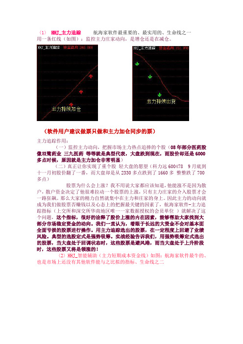
〈1〉HHJ_主力追踪航海家软件最重要的、最实用的、生命线之一用一条红线(如图):监控主力庄家动向,是增仓还是在减仓。
(软件用户建议做票只做和主力加仓同步的票)主力追踪作用:(一)监控主力动向,把握市场主力热点追捧的个股(08年部分医药股像双鹭药业三九医药等等就是典型代表,大盘跌到现在,而股价却还是6000多点时候,原因就是主力加仓非常明显)(二)真正让你实现了重个股轻大盘的愿望(科力远600478 9月底到十一月初股价翻了一番,而大盘却是从2330多点跌到了1660多整整跌了700多点)股票为什么会上涨?我不用说大家都应该知道,他能涨不是因为散户,散户资金决定了他很难拉动一个股票的上涨,只有主力庄家的介入股票才会一路狂飙。
那么大家的精力自然就集中在主力和庄家的身上。
因此主力的动向就成为我们做股票否赚钱以及心态上的把握最关键的因素了,航海家软件-主力追踪指标(上交所和深交所华南地区唯一一家数据授权的会员单位)就解决了这个问题,这个指标,很好的诠释了股价上涨的内在因素,能够帮助大家找到大部分市场稳定资金的动向。
我们一直认为,着眼于长远的大资金不会对基本面全面亏损的股票进行操作。
用主力追踪选出的股票,在一定程度上回避了业绩风险。
典型的选股定式是强势吸筹。
实战经验告诉我们,用强势吸筹定式选出的股票,当大盘处于回调状态时,这些股票是避风港,而当大盘处于上升阶段时,这些股票又将是领涨的!〈2〉HHJ_智能辅助(主力短期成本资金线)如图:航海家软件最牛的、也是市场上还没有其他软件能与之比拟的指标、生命线之二(个股000963 图)主力成本线的作用:(一) 判断你跟主力庄家的关系(是朋友还是敌人关系,选择最佳关系-朋友关系),因此不管大盘涨和跌,我们只要做和主力成为朋友的关系,才是最好的。
所以有航海家软件,大盘涨还是跌跟我们没有关系,主力做一只票的几个步骤:建仓 - 拉高- 洗盘- 再次拉高- 彻底出货(那么每次回调到主力成本线附近都是你考虑低吸/补仓的机会)(大盘走势图)(600478九月底-十一初走势图)(600161 九月底-十一初走势图)(600488大盘跌和主力成为朋友抗跌)(游资快速拉升背后的原因就是和主力成为朋友)也许大家觉得这些是过去的事情了那么咱门看看大盘08年底的7阴一假阳时个股在航海家主力成本线的走势图。
航海家软件技术指标
航海家软件技术指标航海家软件技术指标是指在航海家软件中使用的技术指标,用于分析市场走势和预测未来价格趋势。
这些技术指标可以帮助航海家软件的用户做出更明智的交易决策,提高交易效益。
下面我将详细介绍几个常用的航海家软件技术指标。
1. 移动平均线(Moving Average,MA)移动平均线是一种基本的技术指标,它是通过计算一段时间内的收盘价的平均值来显示价格趋势的。
常见的移动平均线包括简单移动平均线(SMA)和指数移动平均线(EMA)。
2. 相对强弱指标(Relative Strength Index,RSI)相对强弱指标是一种衡量市场超买超卖程度的指标,它根据一定时期内的价格变动程度来确定市场力量的强弱。
通常RSI指标在0-100之间进行波动,70以上被认为是超买区域,30以下被认为是超卖区域。
3. 随机指标(Stochastic Oscillator)随机指标是一种基于收盘价在一段时间内的位置来计算的指标,它通过比较收盘价与最高价和最低价之间的位置关系来判断市场的超买超卖情况。
通常随机指标在0-100之间波动,80以上被认为是超买区域,20以下被认为是超卖区域。
4. 成交量指标(Volume)成交量指标主要用于衡量交易量的变化,是分析市场趋势和价格变动的重要指标之一、通过观察成交量的变化可以判断市场的买卖力量,从而辅助分析市场的走势。
5. 布林带指标(Bollinger Bands)布林带指标是一种由三条轨道组成的指标,由中轨和上下轨组成。
中轨是一条简单移动平均线,上下轨是中轨加减标准差的两条线。
布林带指标可以帮助判断市场趋势的强弱和交易区间,当价格触及布林带的上轨或下轨时,往往意味着市场即将发生反转。
6. 动量指标(Momentum)动量指标是一种测量市场变动速度的技术指标,它通过比较当前价格与指定时间段前的价格之间的差异来判断市场的上涨或下跌动能。
动量指标可以帮助判断价格趋势的持续性和确认市场的拐点。
- 1、下载文档前请自行甄别文档内容的完整性,平台不提供额外的编辑、内容补充、找答案等附加服务。
- 2、"仅部分预览"的文档,不可在线预览部分如存在完整性等问题,可反馈申请退款(可完整预览的文档不适用该条件!)。
- 3、如文档侵犯您的权益,请联系客服反馈,我们会尽快为您处理(人工客服工作时间:9:00-18:30)。
软件基本操作和指标介绍
一、安装和卸载软件
1、软件的安装:
1) 软件安装包(Setup.exe文件)的获得方法:
方法一、在本公司附送的光盘上即可找到Setup.exe文件:
方法二、a.登录我公司网站:,点击下载中心,或者直接登录以下网站:
/Download.aspx
b.点击“航海家安装包”,出现窗口,下载本软件,点击“保存”后,这里可以选择您所要保存
安装包的地方,点击“保存”。
c.下载完成以后是一个压缩包,由于软件的不断更新,上传的压缩包的名字可能有所不同。
解
压即可得Setup.exe文件。
2) 开始安装:
a.双击Setup.exe文件,运行安装程序。
b.阅读欢迎辞后点击“下一步”按钮图标进入许可使用协议界面。
c.阅读许可使用协议后,点击“我同意该许可协议的条款”并单击“下一步”按钮图标。
如果想改变安装位置,可以点击“浏览”,选择安装软件的目标文件夹。
d.接下来基本上可以直接点击“下一步”,直到出现“安装完成”界面,桌面上将自动生成航海家的图标。
e.上述的任一步骤中,用户都可以点击“取消”来退出安装程序,航海家证券决策系统将不被安装。
2、软件的卸载
方法一、用户进入Windows操作系统之后,依次点击“开始→程序→航海家证券决策系统”单击“卸载航海家证券决策系统”项,就可以卸载航海家软件了。
方法二、依次点击“开始→设置→控制面板”进入控制面板,双击“添加/删除程序”按钮图标,在当前安装的程序内选择“航海家证券决策系统”,单击“删除”按钮图标进行卸载。
二、软件启动介绍和登录界面
1、双击桌面上“航海家证券决策系统”快捷方式(如下图),即可进入航海家软件的登陆界面:
三、航海家软件功能介绍与指标调用
鼠标移到软件界面最左边,点一下左键,弹出指标“控制面板”,选择相应的指标双击即可打开指标,双击其它指标可切换指标。
(下图)
把鼠标移动指标的图标就可以显示图标的说明
软件多图结合功能(可以挑自己喜欢的指标结合使用)
智能选股方案:
四、航海家软件部分指标说明和核心功能讲解
航海家软件独立佣有的主力跟风散户三方资金分时图
主力和跟风统计是旗舰版特有指标,监测分时行情主力跟风波动! 散户统计是水手版特有指标,监测分时行情散户波动!
当日资金活跃:这是指当日主力,跟风,散户资金的异动监控,当主力持续异动时往往就是股价的主升浪,而当天交易散户占主导的时候,往往是风险的信号。
大部分时间,以跟风资金和散户资金的博弈为主。
而跟风资金的进出方向主要是以大盘为风向标的。
分类资金流向:这是监控阶段性主力,跟风及散户资金的方向,一般来讲,当主力为正向时并持续增加时,股价具备继续向上能力,主力,跟风,散户同时增加时,股价具备飚升条件,而当出现分岐时,则往往可能是出货或者吸筹,参看前面的资金分析模式。
(主力>80时,代表对股价具备绝对影响力---主力拉升)单击图示区域可以进行当日资金活跃与分类资金
流向的切换。
主力拉升/吸筹监控
主力拉升:主力增仓创近期新高,而股价正处于主升区的个股。
主力吸筹:主力增仓创近期新高,而散户筹码处于下降阶段的个股。
当日增/减仓监控
当日增仓:当日主力净买入量比较靠前的个股。
当日减仓:当日主力净卖出量比较靠前的个股。
(当日增仓适合于行情比较火爆的追涨行情,而当日减仓适合监控市场的风险方向)
波段定位平台:股价未来变化辅助预判系统。
中线强势:即个股股价在潜龙飞天线之上的高度值,越大,则代表个股跑赢大势的强度为高,一般来讲机构介入的深度越强,此类为我们中线需要关注的个股。
短线上攻:当前市场领头上涨的个股,代表市场短期热点的方向,但注意一般当数值超过10时是临界点,要么连续突破向上,要么就是短期的顶部,因此对于短线追涨来讲要考虑到整个大盘的持续性,如果个股在短线超过10以上出现卖出信号要及时先离场。
快进快出。
强庄控盘:发现高控盘强庄的利器,牛市环境中可以找出机构或者主力深度重仓并且对于盘面具有超强操控能力的个股。
往往是牛市中的大龙头。
以下形态所示一样:
这个又是另外五种形态“强者恒强”,一般是操作强势通道
航海家漏斗选股功能还有静态和动态之分,以上是动态合适盘中选股,
以下是静态合适盘后选股
关于静态漏斗操作思路跟动态漏斗是一样的,不在作过多的说明如想更详细的了解航海家软件,请联系相关的业务人员!
31。