南非 理查德湾港口资料
世界主要港口
世界主要港口加拿大(Canada)哈利法克斯港埠公司(Halifax Port Corporation) 哈密尔顿港(Portof Hamilton)蒙特利尔港(Port of Montreal)圣约翰港埠公司(Saint John PortCorporation)多伦多港(Port of Toronto)锡得尼港(Port of Sydney-Canada)埃尔波尼港(Port Alberni)贝塞德港(Port of Bayside)贝拉顿港(Port of Belledune)彻奇尔港(Port of Churchill)达尔豪西港(Port of Dalhousie)鲁珀特港埠公司(Prince RupetPort Corporation)魁北克港(Port of Québec)墨西哥(Mexico)维拉克鲁斯港(Puerto de Veracruz)马萨特兰港(Port ofMazatlan)美国(United States)安那柯的斯港(Port of Anacortes)巴尔的摩港(Port ofBaltimore)贝灵哈姆港(Port of Bellingham, Wa.)查尔斯顿港(Port ofCharleston)克珀斯-克里斯堤港(Port of Corpus Christi)卡拉玛港(Portof Kalama)格雷斯港(Port of Grays Harbor)休斯顿港(AutoridadPortuaria de Houston)维特曼港(Port of Whitman)杰克森维尔港(Port ofJacksonville)洛杉矶港(Port of Los Angeles)莫比尔港(Port of Mobile)新罕布什尔港(New Hampshire Port Autority)塔科马港(Portof Tacoma)威尔明顿港(Port of Willmington)奥克兰港(Port of Oakland)斯托克顿港(Port of Stockton)圣路易斯港(St. Louis PortAuthority)亚瑟港(Port of Port Arthur)波特兰港(Port of Portland)圣保罗港(The Saint Paul Port Authority)圣地亚哥港(Portof San Diego)西雅图港(Port of Seattle)纽约-新泽西港(Port Authority of New York and New Jersey)费城-卡姆登港(Port of Philadelphia and Camden)匹兹堡港管理委员会(Port of Pittsburg Commission)印第安那港口管理委员会(Indiana Port Commission)德拉华河港口管理局(Delaware River Port Authority) 北卡罗来纳港(North Carolina State Ports Authority)非洲地区安哥拉(Angola)罗安达港(Port of Luanda)德班港(Port of Durban)理查德湾港(Port of Richards Bay)塞丹哈港(Port of Saldanha)开普敦港(Port of Capetown)伊丽莎白港(Port of Port Elizabeth)莫斯湾港(Port of MosselBay)东伦敦港(Port of East London)南美洲地区阿根廷(Argentina)阿根廷港口(Ports of Argentina)布兰卡港(Port of BahiaBlanca)里伐达维亚港(Comodoro Rivadavia)马德普拉塔港(Mar delPlata Port)巴拿马(Panama)巴拿马港口国家管理局(National Port Authority of Panama)巴西(Brazil)伊塔日阿伊港(Port of Itajai)达.马德拉港(Port of Pontada Madeira)里奥格兰特港(Port of Rio Grande)萨尔瓦多港(Port ofSalvador)圣多斯港(Port of Santos)维多利亚港(Port of Vitoria)巴巴多斯(Barbados)巴巴多斯港(Port of Barbados)哥伦比亚(Colombia)布韦那文图拉港(Port of Buenaventura)巴兰基利亚港(Portof Barranquilla)埃尔鲍斯克海港(El Bosque Sea Terminal)萨尔瓦多(El Salvador)阿卡胡特拉港(Port of Acajutla)库图科港(Port of Cutuco)秘鲁(Peru)秘鲁港口国有公司(National Port Enterprise of Peru)智利(Chile)瓦尔帕莱索港(Port of Valparaiso)阿里卡港(Port of Arica)智利港口(Ports of Chile)欧洲地区主要港口比利时(Belgium)安特卫普港(Port of Antwerp)根特港(Port of Ghent)泽不腊赫港(Port of Zeebrugge)克罗地亚(Croatia)克罗地亚港口(Ports of Croatia)丹麦(Denmark)奥尔堡港(Port of Aalborg)奥尔胡斯港(Port of Aarhus)奥本罗港(Port of Aabenraa)芬兰(Finland)上海港(Port of ShangHai)芬兰港口(Finnish Ports)赫尔辛基港(Port of Helsinki)盖密港(Port of Kemi)科科拉港(Port of Kokkola)科特卡港(Port of Kotka)奥鲁港(Port of Oulu)波里港(Port of Pori)彼太萨立港(Port of Pietsarsaari)腊黑港(Port of Raahe)托尔尼奥港(Port of Tornio)哈米纳港(Port of Hamina)法国(France)波尔多港(Port of Bordeaux)布勒斯特港(Port of Brest)勒阿弗尔港(Port of Le Havre)德国(Germany)汉堡港(Port of Hamburg)直布罗陀(Gibraltar)直布罗陀港(Port of Gibraltar)希腊(Greece)塞色勒狄克港(Port of Thessaloniki)冰岛(Iceland)雷克亚未克港(Port of Reykjavik)意大利(Italy)热那亚港(Port of Geneva)斯培西亚港(Port of La Spezia)那不勒斯港(Port of Napoli)拉文纳港(Port of Ravenna)萨累诺港(Port of Salerno)萨沃纳港(Port of Savona)奥古斯塔港(Port of Augusta)拉脱维亚(Latvia)拉脱维亚港口(Ports of Latvia)荷兰(Netherlands)鹿特丹港(Port of Rotterdam)挪威(Norway)奥斯陆港(Port of Oslo)苏拉港(Port of Sola)波兰(Poland)格但斯克港(Port of Gdansk)斯文诺斯切港(Port ofSwinoujscie)葡萄牙(Portugal)锡土巴尔港(Port of Setúbal)锡尼什港(Port of Sines)罗马尼亚(Romania)康斯坦萨港(Port of Constantza)俄罗斯(Rusia)诺沃罗西斯克港(Port of Novorossiysk)圣彼得堡港(SaintPetersburg Port Authority)乌斯特-鲁戈港(Port of Ust-Luga)符拉迪敖斯托克港(Portof Vladivostok,即海参威港)西班牙(Spain)巴塞罗那港(Port of Barcelona)卡塔赫纳港(Port ofCartagena)桑坦德港(Port of Santander)毕尔巴鄂港(Port of Bilbao)拉.科鲁纳港(Port of La Coruña)塔腊戈纳港(Port ofTarragona)维利亚加西亚.德.阿罗萨港(Port of Vilagarcia de Arosa)卡的斯港(Port of Cadiz)拉斯柏尔马斯港(Port of Las Palmas)巴伦西亚港(Port of Valencia)马拉加港(Port of Malaga)阿尔梅里亚港(Ports of Almeriaand Motril)休达港(Port of Ceuta)瑞典(Sweden)瑞典港口(Swedish Ports)法尔肯贝里港(Port of Falkenberg)哥德堡港(Port of Goteborg)哈尔姆斯塔德港(Port ofHalmstad)赫纳散德港(Port of Harnsosand)赫尔辛堡港(Port ofHelsingborg)马尔默港(Port of Malmoe)诺尔彻平港(Port of Norrkopings)塞德特里耶港(Port of Sodertalje)瓦尔汉姆港(Port de Wallhamn)英国(United Kingdom)英吉利港口(Associated British Ports)埃尔和特隆港(Ayrand Troon)巴罗港(Barrow)巴里港(Barry)加的夫港(Cardiff)科尔切斯特港(Colchester)弗利特伍德港(Fleetwood)加斯顿港(Garston)古耳港(Goole)格里姆斯比港(Grimsby)赫尔港(Hull)伊明翰港(Immingham)金斯林港(King´s Lynn)洛斯托夫特港(Lowestoft)纽波特港(Newport)伦敦港口管理局(Port of LondonAuthority)普列茅斯港(Plymouth)锡洛斯港(Silloth)南安普顿港(Southampton)斯温西港(Swansea)泰尔柏特港(Talbot)廷默思港(Teignmouth)惠特比港(Whitby)贝尔法斯特港(Port of Belfast)中国(China)上海港(Port of ShangHai)连云港港(Port of Lianyungang)宁波港(Port of NingBo)大连港(Port of Dalian)青岛港(Port of QingDao)香港港口(Port of Hong Kong)高雄港(Port of kaohsiung)花莲港(Port of Hualien)基隆港(Port of Keelung)台中港(Port of Taichung)韩国(Korea)釜山港(Port of Busan)仁川港(Port of Inchon)木蒲港(Port of Mokpo)日本(Japan)神户港(Port of Kobe)名古屋港(Port of Nagoya)横滨港(The Port of Yokohama)川崎港(Port of Kawasaki)梗津港(Port of Kisarazu)北九州港(Port of Kitakyushu)酒田港(Port of Sakata)千叶港(Port of Chiba)科威特(Kuwait)科威特港(Kuwait Ports Public Authority)马来西亚(Malaysia)民都鲁港(Bintulu Port Authority)柔佛港(Johore PortAuthority)昆坦港(Kuantan Port Authority)古晋港(Kuching PortAuthority)马六甲港(Malacca Port Authority)阿联酋(United Arab Emirates)迪拜港(Port of Dubai)菲律宾(Philippines)马尼拉港(Manila)印度(India)加尔各答港(Port of Calcutta)贾瓦哈拉港(Port ofJawaharlal)孟买港(Port of Mumbai)印度尼西亚(Indonesia)丹绒布绿港(Port of Tanjung Priok)以色列(Israel)以色列港(Israel Ports and Railways Authority)巴基斯坦(Pakistan)卡拉奇港(Port of Karachi)Singapoore(新加坡)新加坡港(Port of Singapore Authority)世界主要港口,按字母顺序排名的Aabenraa,奥本罗,Denmark,丹麦·Adelaide,阿德莱德,Australia,澳大利亚·Acajutla,阿卡胡特拉,El Salvador,萨尔瓦多·Aabenraa,奥本罗,Denmark,丹麦·Aalborg,奥尔堡,Denmark,丹麦·Aalesund,奥勒松,Norway,挪威·Aarhus,奥胡斯,Denmark,丹麦·Abadan,阿巴丹,Iran,伊朗·Abbeville,阿布维尔,France,法国·Aberdeen,阿伯丁,USA,美国·Aberdour,阿伯杜尔,United Kingdom,英国·Aberdovey,阿伯多维,United Kingdom,英国·Abidjan,阿比让,Ivory Coast,象牙海岸·Abou Zenima,阿布宰尼迈,Egypt,埃及·Abu Dhabi,阿布扎比,Unite Arab Emirates ·Acapulco,阿卡普尔特,Mexico,墨西哥·Accra,阿克拉,Ghana,加纳·Adabiya,阿达比亚,Egypt,埃及·Adak,李达克,USA,美国·Adalia,安塔利亚,Turkey,土耳其·Aden,亚丁,Yemen,也门·Acajutla, 阿卡胡特拉,El Salvador,萨尔瓦多·Adelaide, 阿德莱德, Australia,澳大利亚·Adra,阿德斯腊,Spain,西班牙·Aeroskobing,埃勒斯克平,Denmark,丹麦·Aeroskobing, 埃勒斯克平,Denmark, 丹麦·Agia Trias,阿伊阿特里阿斯,greece,希腊·Aguadilla,阿瓜迪利亚,Puerto Rico,波多黎各·Aguilas,阿吉拉斯,Spain,西班牙·Ajaccio,阿雅克肖,France,法国AJMAN,阿治曼,United Arab Emirates,阿拉伯联合酋长国·Akaroa,阿卡罗阿,New Zealand,新西兰·Akassa,阿卡萨,Nigeria,尼日利亚·Akita,秋田,Japan,日本·Akureyri,阿库雷里,Iceland,冰岛·Akutan,阿库坦,USA,美国·Akyab,阿恰布,Burma,缅甸·Ala,阿拉,Sweden,瑞典·Alameda,阿拉梅达,USA,美国·Albuquerque,阿尔布开克,Colomia ·Alderney Island,奥尔德尼岛,United Kingdom,英国·aleppey,阿勒皮,India,印度·Alesund,奥勒松,Norway,挪威·Alexandretta,亚历山大勒塔,Turkey,土耳其·Alexandria,亚历山大,Egypt,埃及·Alexandria,亚历山大里亚,USA,美国·Alexandroupolis,亚历山大鲁波利斯,Greece,希腊·Algeciras,阿尔赫西拉斯,Spain,西班牙·Alghero,阿尔盖罗,Etaly·Algiers,阿尔及尔,Algeria,阿尔及利亚·Alicante,阿利坎特,Spain,西班牙·Alkmaar,阿尔克马,Holand,荷兰·Alliance,阿莱恩斯,USA,美国·Allinge,阿林格,Denmark,丹麦·Almeria,阿尔梅里亚,Spain,西班牙·Alotau,阿乐陶,Papua New Guinea,巴布亚新几内亚·Alotau,阿乐陶,Papua New Guinea, 巴布亚新几内亚·Alsen,阿尔森,USA,美国·Alula,阿卢拉,Somalia,索马里·Alvarado,阿尔瓦拉多,Mexico,墨西哥现今世界有各类大小港口约3000多个,其中国际贸易商港约占77%,约有500个港口能停靠3.5万吨级船舶,能靠10万吨级的约有70个。
南非SALDANHA_BAY港简介
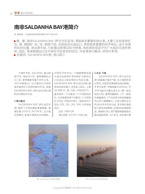
南非SALDANHA BAY港简介◎ 陈楚斌 中远海运船员管理有限公司广州分公司摘 要:南非SALDANHA BAY(萨尔达尼亚湾)港是南非重要的商业港,主要工业包括铁矿石、煤、精铜矿、铅、锌、钢铁产品、花岗岩及石油出口,具有极其重要的经济地位。
由于该港所处的位置、进出港手续、引航靠泊等情况较为特殊,有些新的规定不为广大船员兄弟所熟知,因此,笔者根据自己在中海年华轮装货的经历,对该港进行概述,供同行参考。
关键词:SALDANHA BAY港;港口简介中海年华轮,总长330米、最大船宽57米、型深28.6米、夏季满载吃水22.1米、夏季满载货量315041公吨。
2012年新船出厂后主要执行巴西和南非装铁矿石回国的航次任务。
现就SALDANHA BAY(萨尔达尼亚湾)港的有关情况作介绍。
1.港口概况SALDANHA BAY(萨尔达尼亚湾)港是个天然良港和重要海港,地理位置(33°02´S,017º58´E),位于南非西海岸,距离开普敦以北60海里。
20世纪70年代由一个渔港慢慢发展为现在包括铁矿等多种矿石散货出口及进出口原油等综合性深水港。
SALDANHA BAY(萨尔达尼亚湾)港是南非国有港口,没有私人码头。
主要出口铁矿石、煤、石油。
共有泊位7个,最外面有一个可靠泊三十万吨原油泊位,往内接着有两个可靠泊三十万吨铁矿石泊位(OBL&OBS),接着有四个泊位(201、202、203、204)为多用途泊位。
区时:GMT+2H海水密度:在1.023~1.026之间。
2.水文、气象SALDANHA BAY(萨尔达尼亚湾)港属地中海式气候,处于副热带高压带内,经常受好望角附近低压影响。
冬季为雨季,年降雨量为300mm,年平均气温为15摄氏度左右。
雾一般出现在3-8月,夏季吹偏南风。
上午一般吹东南偏南风,下午则会转为吹西南偏南风且风力稍微增大。
冬季主要吹东北风/西北风并伴有小雨。
南非主要港口概况

南⾮主要港⼝概况南⾮主要港⼝概况1.引⾔⾮洲⼤陆约3 020万平⽅千⽶(包括附近岛屿)。
约占世界陆地总⾯积的20.2%,次于亚洲,为世界第⼆。
⼈⼝74 800万,占世界⼈⼝总数12.9%。
⾮洲⽬前有56个国家和地区。
在地理上,习惯将⾮洲分为北⾮、东⾮、西⾮、中⾮和南⾮五个地区。
⾃上世纪五、六⼗年代以来,⾮洲国家纷纷独⽴,经过了⼏⼗年的发展,⾮洲经济有了⼀定的进步,但仍然是世界上较为落后的,⼈均GDP排名靠后,基础设施普遍落后,尤其是港⼝,货物拥堵、平均等待时间长、港⼝腐败、管理机制落后等问题⼀直制约着⾮洲港⼝的发展。
在全世界排名前五⼗的港⼝中⾮洲仅有两个,⼀个是北⾮埃及的塞得港,另⼀个就是⾮洲南部的德班港。
与⾮洲绝⼤多数国家不同的是,南⾮由于其独特的地理位置,丰富的矿产资源,使之成为⾮洲发展领先的国家之⼀,对外贸易和转⼝贸易在南⾮经济中⽐重很⼤,⽽港⼝在对外贸易中扮演了重要作⽤。
南⾮除了跻⾝世界前五⼗的德班港以外,其他⼏个重要的港⼝如伊丽莎⽩港、开普敦港和东伦敦港等在国占据重要地位,⽆论是吞吐量还是基础设施⽅⾯在⾮洲港⼝中均排名靠前。
本⽂主要介绍了南⾮主要的六个港⼝,研究了近年来港⼝的发展状况,并针对相应的问题提出⼀些建议,2.地理概况南⾮位于⾮洲的最南端,全称为南⾮国。
⾯积122.1万平⽅千⽶。
⼈⼝5500万(2015年)[1],70%为⿊⼈。
英语和阿⾮利卡语为通⽤语⾔。
有三个⾸都:⾏政⾸都⼀⽐勒陀利亚;⽴法⾸都—开普敦;司法⾸都⼀布隆⽅丹。
最早的⼟著居民是桑⼈、科伊⼈及后来南迁的班图⼈。
1 7世纪后,荷兰⼈、英国⼈相继⼊侵并不断将殖民地向地推进。
19世纪中叶,⽩⼈统治者建⽴起政治实体:两个英国殖民地⼀开普、纳塔尔殖民地;两个布尔⼈国——德兰⼠⽡南⾮国和奥兰治⾃由邦。
1899~1902年英荷战争以英国⼈艰难取胜告终。
1910年,四个政权合并为“南⾮联邦”,成为英国的⾃治地,1961年5⽉31⽇退出英联邦,成⽴南⾮国。
非洲港口基本情况

东非港口的规定:东非的港口不多,也不需要像西非那样的进口批准号,但是东非的海关可是出名的严格的。
最离谱的事情是TMM的海关,他们曾经扣住我国的一票货,理由是海关不接受一个集装箱里只有一件商品。
DAR ES SALAAM 达累斯萨拉姆(TANZANIA坦桑尼亚):达累斯萨拉姆是通往非洲内陆国家的重要口岸之一,所有经过DAR转运货都需要在DAR进行转关手续,需要发货人在货到港之前向船公司提供箱单,invoice和正本提单复印件,船公司会把上述文件扫描给DARagent办转关手续。
但货运运抵目的国,收货人还需要自己做一次真正的清关手续方能提货。
值得一提的是DAR海关还会关注商品的货值,如果他们认为货值过低会要求客户更改invoice,但是客户态度非常坚持,他们最终还是会放行。
另外,船公司通常对转运货的限重是连箱重13.5TONS/20',27TONS/40'。
南非港口的规定:有必要提醒的是南非转到内陆的货重等级很严格,一旦超重船公司一定会加收额外的转运费。
西非港口的规定:西非港口的规定最多,总结起来基本上都是需要各种名目的进口许可证号。
以下逐一说明。
据我了解,如果是私人物品应该不需要这些批号,如果客户无法提供相关的号码,船公司通常不会签发提单。
出于某些原因实在无法提供号码,需跟船公司商议是否可以出具保函,要求船公司放单。
特别提醒,西非各国家海关是我认为最严格的,所以千万不要货到港后在更改,罚金是惊人的!1)COTONOU (BENIN)关键字:CTN NO.CTN(CARGO TRACKING NOTE)=BSC(BORDEREAU DE SUIVI DE CARGAISON)号码,显示在提单和舱单上的品名描述部分。
CTN NO. 由收货人向当地进口管理机构索取。
2)LAGOS(APAPA)/ONNE (NIGERIA)关键字:CRI NO.CRI (CLEAN REPORT OF INSPECTION),显示在提单和舱单上的品名描述部分。
南非的主要港口

南非的主要港口南非是一个非常重要的国家,拥有许多主要港口,这些港口不仅是南非内部发展的重要枢纽,还是南非与世界其他国家进行贸易和交流的门户。
在本文中,我们将讨论南非的主要港口及其对南非经济的影响。
开普敦港口在南非的主要港口中,开普敦港口位于最南端,是地理位置和交通运输的重要枢纽。
开普敦港口是东南亚、澳大利亚、欧洲和南美洲的重要贸易伙伴,并通过多种海上运输方式连接非洲国家。
开普敦港口还提供国际透明的商务环境、广泛的补贴体系、并帮助企业在降低成本和提高生产力方面实现优势。
达洛港口达洛港口位于南非的东南部,是南非最大的港口之一,也是南非经济的重要支柱。
作为荷兰和日本重要的贸易伙伴,达洛港口在输送大量的物资方面极为重要。
该港口还是世界上船只装卸速度最快和技术最先进的大型港口之一,并且在不断增加物流服务功能的同时,成为世界上最大的船舶加油站之一。
杰堡港口杰堡港口位于南非本土的中心地带,是连接南非内部和世界各地的重要通道。
杰堡港口主要为战略性重要的商业业务和工业项目提供服务,包括冶金工业、油气开采、矿业和制造业等领域。
此外,杰堡港口还提供各种不同种类的货物的进出口,使南非可以与各种贸易伙伴进行贸易。
伊丽莎白港口伊丽莎白港口位于南非东南部,是南非最新且最具先进性的港口之一,目前正在扩建,成为更大规模的物流贸易中心。
伊丽莎白港口未来将成为南非物流贸易发展的基石,提供新兴市场的趋势和不断增长的贸易需求。
南非的港口体系是非常好的,不仅能够为南非带来更多的投资机会,而且在不断发展的过程中,会推动南非经济的稳步发展。
这些港口在南非的现代化化和国家经济的发展过程中发挥着重要的作用,成为南非不可或缺的经济发展支柱。
南非港口介绍
南非港口介绍
无
【期刊名称】《水运文献信息》
【年(卷),期】2005(000)011
【摘要】南非的主要港口,从其西部的萨尔达尼亚湾西角港起,以逆时针方向数,开普敦港、伊丽莎白港、东伦敦港、德班港和理查兹贝六大港口。
而南非的东北地区边境有邻国莫桑比克的马普托港、贝拉港和纳卡拉港,也可以作为在南非经营进出口贸易的托运人选择的通道。
【总页数】1页(P17)
【作者】无
【作者单位】无
【正文语种】中文
【中图分类】U691.1
【相关文献】
1.港口门机接电新技术的应用——介绍一种实用新型的港口门座起重机岸边接电箱[J], 吴再鲲;丁秀瑜;丁汉辉;谢汉章
2.连通世界的南非港口群像 [J],
3.走进南非港口 [J], Jayendu Krishna
4.疫情下“中国制造”获青睐,振华重工中标南非港口跨运车项目 [J],
RMIX在港口管理中的应用——介绍一个港口火车装卸统计程序 [J], 王培榕
因版权原因,仅展示原文概要,查看原文内容请购买。
世界主要港口一览
世界主要港口一览北美洲地区加拿大(Canada)哈利法克斯港埠公司(Halifax Port Corporation) 哈密尔顿港(Port of Hamilton)蒙特利尔港(Port of Montreal)圣约翰港埠公司(Saint John Port Corporation) 多伦多港(Port of Toronto)锡得尼港(Port of Sydney-Canada)埃尔波尼港(Port Alberni)贝塞德港(Port of Bayside)贝拉顿港(Port of Belledune)魁北克港(Port of Québec)彻奇尔港(Port of Churchill)达尔豪西港(Port of Dalhousie)鲁珀特港埠公司(Prince Rupet Port Corporation)墨西哥(Mexico)维拉克鲁斯港(Puerto de Veracruz)马萨特兰港(Port of Mazatlan)美国(United States)安那柯的斯港(Port of Anacortes)巴尔的摩港(Port of Baltimore)贝灵哈姆港(Port of Bellingham, Wa.)查尔斯顿港(Port of Charleston)克珀斯-克里斯堤港(Port of Corpus Christi)卡拉玛港(Port of Kalama)格雷斯港(Port of Grays Harbor)休斯顿港(Autoridad Portuaria de Houston)维特曼港(Port of Whitman)杰克森维尔港(Port of Jacksonville)洛杉矶港(Port of Los Angeles)莫比尔港(Port of Mobile)新罕布什尔港(New Hampshire Port Autority)塔科马港(Port of Tacoma)威尔明顿港(Port of Willmington)奥克兰港(Port of Oakland)斯托克顿港(Port of Stockton)圣路易斯港(St. Louis Port Authority)亚瑟港(Port of Port Arthur)波特兰港(Port of Portland)圣保罗港(The Saint Paul Port Authority)纽约-新泽西港(Port Authority of New York and New Jersey)费城-卡姆登港(Port of Philadelphia and Camden)匹兹堡港管理委员会(Port of Pittsburg Commission)印第安那港口管理委员会(Indiana Port Commission)德拉华河港口管理局(Delaware River Port Authority) 圣地亚哥港(Port of San Diego)北卡罗来纳港(North Carolina State Ports Authority)西雅图港(Port of Seattle)非洲地区安哥拉(Angola)罗安达港(Port of Luanda)南非(South Africa)德班港(Port of Durban)理查德湾港(Port of Richards Bay)塞丹哈港(Port of Saldanha)开普敦港(Port of Capetown)伊丽莎白港(Port of Port Elizabeth)莫斯湾港(Port of Mossel Bay)东伦敦港(Port of East London)南美洲地区阿根廷(Argentina)阿根廷港口(Ports of Argentina)布兰卡港(Port of Bahia Blanca)里伐达维亚港(Comodoro Rivadavia)马德普拉塔港(Mar del Plata Port)巴拿马(Panama)巴拿马港口国家管理局(National Port Authority of Panama)巴西(Brazil)伊塔日阿伊港(Port of Itajai)达马德拉港(Port of Ponta da Madeira)里奥格兰特港(Port of Rio Grande)萨尔瓦多港(Port of Salvador)圣多斯港(Port of Santos)维多利亚港(Port of Vitoria)巴巴多斯(Barbados)巴巴多斯港(Port of Barbados)哥伦比亚(Colombia)布韦那文图拉港(Port of Buenaventura)巴兰基利亚港(Port of Barranquilla)埃尔鲍斯克海港(El Bosque Sea Terminal)萨尔瓦多(El Salvador)阿卡胡特拉港(Port of Acajutla)库图科港(Port of Cutuco)秘鲁(Peru)秘鲁港口国有公司(National Port Enterprise of Peru)智利(Chile)瓦尔帕莱索港(Port of Valparaiso)阿里卡港(Port of Arica)智利港口(Ports of Chile欧洲地区比利时(Belgium)安特卫普港(Port of Antwerp)根特港(Port of Ghent)泽不腊赫港(Port of Zeebrugge)克罗地亚(Croatia)克罗地亚港口(Ports of Croatia)丹麦(Denmark)奥尔堡港(Port of Aalborg)奥尔胡斯港(Port of Aarhus)奥本罗港(Port of Aabenraa)芬兰(Finland)上海港(Port of ShangHai)芬兰港口(Finnish Ports)赫尔辛基港(Port of Helsinki)盖密港(Port of Kemi)科科拉港(Port of Kokkola)科特卡港(Port of Kotka)奥鲁港(Port of Oulu)波里港(Port of Pori)彼太萨立港(Port of Pietsarsaari)腊黑港(Port of Raahe)托尔尼奥港(Port of Tornio)哈米纳港(Port of Hamina)法国(France)波尔多港(Port of Bordeaux)布勒斯特港(Port of Brest)勒阿弗尔港(Port of Le Havre)德国(Germany)汉堡港(Port of Hamburg)直布罗陀(Gibraltar)直布罗陀港(Port of Gibraltar)希腊(Greece)塞色勒狄克港(Port of Thessaloniki)冰岛(Iceland)雷克亚未克港(Port of Reykjavik)意大利(Italy)热那亚港(Port of Geneva)斯培西亚港(Port of La Spezia)那不勒斯港(Port of Napoli)萨累诺港(Port of Salerno)拉文纳港(Port of Ravenna)萨沃纳港(Port of Savona)奥古斯塔港(Port of Augusta)拉脱维亚(Latvia)拉脱维亚港口(Ports of Latvia)荷兰(Netherlands)鹿特丹港(Port of Rotterdam)挪威(Norway)奥斯陆港(Port of Oslo)苏拉港(Port of Sola)波兰(Poland)格但斯克港(Port of Gdansk)斯文诺斯切港(Port of Swinoujscie)葡萄牙(Portugal)锡土巴尔港(Port of Setúbal)锡尼什港(Port of Sines)罗马尼亚(Romania)康斯坦萨港(Port of Constantza)俄罗斯(Rusia)诺沃罗西斯克港(Port of Novorossiysk)圣彼得堡港(Saint Petersburg Port Authority)乌斯特-鲁戈港(Port of Ust-Luga)符拉迪敖斯托克港(Port of Vladivostok,即海参威港)西班牙(Spain)巴塞罗那港(Port of Barcelona)卡塔赫纳港(Port of Cartagena)桑坦德港(Port of Santander)毕尔巴鄂港(Port of Bilbao)拉科鲁纳港(Port of La Coruña)塔腊戈纳港(Port of Tarragona)休达港(Portof Ceuta)维利亚加西亚.德.阿罗萨港(Port of Vilagarcia de Arosa)卡的斯港(Port of Cadiz)巴伦西亚港(Port ofValencia)拉斯柏尔马斯港(Port of Las Palmas)马拉加港(Port of Malaga)阿尔梅里亚港(Ports of Almeria and Motril)瑞典(Sweden)瑞典港口(Swedish Ports)法尔肯贝里港(Port of Falkenberg)哥德堡港(Port of Goteborg)哈尔姆斯塔德港(Port of Halmstad)赫纳散德港(Port of Harnsosand)赫尔辛堡港(Port of Helsingborg)马尔默港(Port of Malmoe)诺尔彻平港(Port of Norrkopings)塞德特里耶港(Port of Sodertalje)瓦尔汉姆港(Port de Wallhamn)英国(United Kingdom)英吉利港口(Associated British Ports)埃尔和特隆港(Ayr and Troon)巴罗港(Barrow)巴里港(Barry)加的夫港(Cardiff)科尔切斯特港(Colchester)弗利特伍德港(Fleetwood)加斯顿港(Garston)古耳港(Goole)格里姆斯比港(Grimsby)赫尔港(Hull)伊明翰港(Immingham)金斯林港(King´s Lynn)洛斯托夫特港(Lowestoft)纽波特港(Newport)伦敦港口管理局(Port of London Authority)普列茅斯港(Plymouth)锡洛斯港(Silloth)南安普顿港(Southampton)斯温西港(Swansea)泰尔柏特港(Talbot)廷默思港(Teignmouth)惠特比港(Whitby)贝尔法斯特港(Port of Belfast)亚洲地区中国(China)上海港(Port of ShangHai)连云港港(Port of Lianyungang)宁波港(Port of NingBo)大连港(Port of Dalian)青岛港(Port of QingDao)香港港口(Port of Hong Kong)高雄港(Port of kaohsiung)花莲港(Port of Hualien)基隆港(Port of Keelung)台中港(Port of Taichung)韩国(Korea)釜山港(Port of Busan)仁川港(Port of Inchon)木蒲港(Port of Mokpo)日本(Japan)神户港(Port of Kobe)名古屋港(Port of Nagoya)横滨港(The Port of Yokohama)千叶港(Port of Chiba)川崎港(Port of Kawasaki)梗津港(Port of Kisarazu)北九州港(Port of Kitakyushu)酒田港(Port of Sakata)科威特(Kuwait)科威特港(Kuwait Ports Public Authority)马来西亚(Malaysia)民都鲁港(Bintulu Port Authority)柔佛港(Johore Port Authority)昆坦港(Kuantan Port Authority)古晋港(Kuching Port Authority)马六甲港(Malacca Port Authority)阿联酋(United Arab Emirates)迪拜港(Port of Dubai)菲律宾(Philippines)马尼拉港(Manila)印度(India)加尔各答港(Port of Calcutta)贾瓦哈拉港(Port of Jawaharlal)孟买港(Port of Mumbai)印度尼西亚(Indonesia)丹绒布绿港(Port of Tanjung Priok)以色列(Israel)以色列港(Israel Ports and Railways Authority)巴基斯坦(Pakistan)卡拉奇港(Port of Karachi)Singapoore(新加坡)新加坡港(Port of Singapore Authority)。
南非主要的六大港口
南⾮主要的六⼤港⼝南⾮的主要港⼝,从其西部的萨尔达尼亚湾西⾓港起,以逆时针⽅向数,开普敦港、伊丽莎⽩港、东伦敦港、德班港和理查兹贝六⼤港⼝。
⽽南⾮的东北地区边境有邻国莫桑⽐克的马普托港、贝拉港和纳卡拉港,也可以作为在南⾮经营进出⼝贸易的托运⼈选择的通道。
萨尔达尼亚湾西⾓港和莫桑⽐克境内的纳卡拉港的⾃然条件最好,可谓⾮洲⼤陆之最。
萨尔达尼亚湾西⾓港位于开普敦港西北⽅向60海⾥,进出⼝航道深度超过23⽶。
⽽位于⼤港湾内的纳卡拉港得天独厚,有⾃然保护屏障,不受印度洋⼤风⼤浪的侵袭,其航道⽔深超过60⽶,港⼝出⼊⼝宽达800⽶,不少国际经济分析家认为,这两个港⼝发展潜⼒巨⼤,值得国际开发商和投资商关注。
由于历史、政治条件和种族⽭盾等⽅⾯的原因,这两个港⼝的发展⽐较落后,两地港务公司经理曾希望笔者向有兴趣到南部⾮洲投资发展的中国有关企业,转达他们的招商信息,希望中国港务码头公司能帮助他们改变⽬前“端着⾦碗要饭吃”的穷困境地。
此外,莫桑⽐克境内濒临印度洋的贝拉港,是赞⽐亚和津巴布韦的海上通商⼝岸,但贝拉港⼝航道沙洲浅滩多,只能停靠吃⽔不到5⽶的船舶,乘潮进出港,最多只能挂靠吃⽔7.4⽶的船舶。
莫桑⽐克境内的马普托港,现在仍然是以南⾮约翰内斯堡为中⼼的⾼登地区制造加⼯业托运⼈最喜欢挑选的进出⼝港,与约翰内斯堡相距⼤约555公⾥。
马普托港的码头费率低于德班港,也没有德班港那样拥堵,约翰内斯堡与马普托港之间有四车道现代化⾼速公路通⾏,因此,越来越多的南⾮托运⼈喜欢从马普托港进出⼝货物。
不过,莫桑⽐克与南⾮之间的边境检查站是上午7点半开始放⾏,下午6时关闭,晚上严禁通⾏,这常常造成集装箱卡车在边境哨卡两侧的公路上排长队等候。
马普托港上午11点半⾄下午1点是装卸⾼峰,卡车装车后必须加快⾏驶,以赶在下午6时前抵达边境办理海关⼿续,否则就要等候⼀夜。
从港⼝吞吐量讲,南⾮规模最⼤的港⼝是位于南⾮东南地区,濒临印度洋,直到1976年才正式开港的理查兹贝港,但是⽬前理查贝兹港的进出⼝货物⼤多是煤炭、矿砂。
主要煤炭装港港口资料
VOSTOCHNY/东方港#港口性质:海湾港#经纬度:42°44′N,133°04′E#位于俄罗斯(全称:俄罗斯联邦THE RUSSIAN FEDERATION)东南沿海的弗兰格尔(VRANGEL)湾内,濒临纳霍德卡(NAKHODKA)湾的东南侧,是俄罗斯远东地区的最大港口。
始建于70年代,第一期工程在1980年完成。
该港与纳霍德卡(NAKHODKA)港相邻都是俄罗斯远东地区的对外贸易的进出门户。
它们通过西伯利亚大陆桥与包括俄罗斯欧洲心脏地区在内的广大腹地连在一起。
目前已发展成为俄罗斯东方大港。
港口距纳霍德卡港约10n mile。
该港属温带季风气候,盛行西北风。
年平均气温夏季为20℃,冬季为-10℃。
每年1~3月有薄冰,须破冰船协助开航。
一年之中有70%的日期有雾,6~7月平均每月有18天。
全年平均降雨量约1000mm。
平均潮高:高潮约0.7m,低潮约0.48m。
港区主要码头泊位如下:码头类别泊位(个)岸线长(m)最大水深(m)─────────────────────────────GENERAL CARGO (杂货) 4 396 11.8BULK CARGO (散货) 2 610 16.5CONTAINER (集装箱) 3 350 12.2──────9 1311装卸设备有各种岸吊、集装箱吊、吸片机及装载机等。
煤码头有外伸距28.2m,升高18m的装载机,装速每小时3000吨,原木码头有专用真空吸木片载运机和各种车辆。
码头最大可靠10万载重吨的船舶。
大船锚地水深达28m。
年货物吞吐能力约1300万吨,约占俄罗斯太平洋港口总吞吐量21%。
主要出口货物为煤、木材、木板及杂货等,进口货物主要有粮谷,汽车及杂货等。
在节假日中如果需要,可以安排作业,但须付加班费。
本港第二期工程预计在1997年完成,将增加集装箱吞吐能力约7万TEU,煤炭吞吐能力约600万吨。
RICHARDS BAY 理查兹贝港口介绍RICHARDS BAY/理查兹贝#港口性质:海港经纬度:28°48′S,032°06′E#位于南非(全称:南非共和国THE REPUBLIC OF SOUTH AFRICA)东北沿海,南距德班港86n mile,濒临印度洋的西南侧,是南非的主要煤炭输出港,也是世界第二大散货港。
非洲国家英文名称音标及港口
非洲国家英文名称音标及港口非洲1. Algeria 阿尔及利亚[ æl'dʒiəriə ]2. Angola 安哥拉[ æŋ'gəulə ] .罗安达港(Port of Luanda)3. Benin 贝宁4. Botswana 博茨瓦纳[ bɔts'wɑ:nə ]5. Burkina-faso 布基纳法索6. Burundi 布隆迪[ bə'rʌndi ]7. Cameroon 喀麦隆[ 'kæməru:n ] . .8. Cape Verde佛得角9. Central African Republic 中非共和国10. Chad 乍得[ tʃæd ] .11. Comorin科摩罗[ 'kɔmərin ]12. Congo 刚果[ 'kɔŋgəu ] .13. Democratic Republic of Congo刚果民主共和国14. Djibouti 吉布提[ dʒi'bu:ti ]15. Egypt 埃及[ 'i:dʒipt ]16. Equatorial Guinea赤道几内亚[ ,ekwə'tɔ:riəl'gini ] .17. Eritrea厄立特里亚[ ,eri'tri(ə ]18. Ethiopia 埃塞俄比亚[ ,i:θi'əupjə ]19. Gabon 加蓬[ ga'b ]20. Gambia 冈比亚[ 'gæmbiən ]21. Ghana 加纳[ 'gɑ:nə ] .22. Guinea 几内亚[ 'gini ]23. Guinea-Bissau几内亚比绍[ 'gini bi'səu ]24. Ivory Coast 科特迪瓦,象牙海岸[ 'aivəri'kəust ]25. Kenya 肯尼亚[ 'ki:njə, 'kenjə ]26. Lesotho 莱索托[ li'su:tu: ]27. Liberia 利比里亚[ lai'biəriə ]28. Libya 利比亚[ 'libiə ]29. Madagascar 马达加斯加[ mædə'gæskə ]30. Malawi 马拉维[ mɑ:'lɑ:wi ]31. Mali 马里[ 'mɑ:li: ]32. Mauritania.毛里塔尼亚[ ,mɔ(ri'teinjə ]33. Mauritius 毛里求斯[ mə'riʃəs ] . .34. Morocco 摩洛哥[ mə'rɔkəu ] .35. Mozambique 莫桑比克[ 'məuzəm'bi:k ]36. Namibia 纳米比亚[ nə'mi:biə ]37. Niger 尼日尔[ 'naidʒə ]38. Nigeria 尼日利亚[ nai'dʒiəriə ] .39. Rwanda卢旺达[ rʊ'ændə ]40. Reunion 留尼旺[ ri:'ju:njən ] .41. Sao Tome and Principe 圣多美和普林西比[ 'prinsipi: ] .42. Senegal 塞内加尔[ ,seni'gɔ:l ] .43. Seychelles 塞舌尔[ sei'ʃelz ] . .44. Sierra Leone 塞拉利昂[ 'siərə li'əun ]45. Somali 索马里[ səu'mɑ:liə ]46. South Africa 南非德班港(Port of Durban)理查德湾港(Port of Richards Bay)塞丹哈港(Port of Saldanha)开普敦港(Port of Capetown)伊丽莎白港(Port of Port Elizabeth)莫斯湾港(Port of Mossel Bay)东伦敦港(Port of East London)47. Sudan 苏丹[ su:'dæn ]48. Swaziland 斯威士兰[ 'swɑ:zilænd ] .49. Tanzania 坦桑尼亚[ ,tænzə'ni:ə ] . .50. Togo 多哥[ 'təugəu ]51. Tunisia 突尼斯[ tju('niziə52. Uganda 乌干达[ ju(:)'gændə, u:'gændə ]53. Zambia 赞比亚[ 'zæmbiə ] .54. Zimbabwe 津巴布韦[ zim'bɑ:bwei ]55. Zaire 扎伊尔[ 'zairei ]。
- 1、下载文档前请自行甄别文档内容的完整性,平台不提供额外的编辑、内容补充、找答案等附加服务。
- 2、"仅部分预览"的文档,不可在线预览部分如存在完整性等问题,可反馈申请退款(可完整预览的文档不适用该条件!)。
- 3、如文档侵犯您的权益,请联系客服反馈,我们会尽快为您处理(人工客服工作时间:9:00-18:30)。
Berth 609 701 702 703 704 703 / 704 801 804
Length 300,0m 300,0m 240,0m 240,0m 240,0m 240,0m 260,0m 260,0m
Draft 14,0m 14,0m 17,5m 17,5m 17,5m 17,5m 17,5m 17,5m
Load / Discharge Methods Discharge by two vacuum discharge appliance Discharge by mobile + gantry like appliance Discharge by mobile + gantry like appliance Ship loader – Mann Ship loader – Krupp Ship loader – Caillard, servicing both berths Wood chip loader servicing 801 & 804
GAC SHIPPING (SA) PTY LTD SOUTH AFRICA South African Coast line
RICHARDSBAYFra bibliotekRICHARDS BAY Port Information
LATITUDE 28°48’ S
LONGITUDE 32°02’ E
INTRODUCTION A number of factors contributed to the development of Richards Bay. By the early 1970’s, it had become an urgency to provide additional rail links between the coast and the mining heartland of the country. It had also become necessary to provide a deepwater port to accommodate the large bulk carriers calling at South African ports. Richards Bay was chosen for five important reasons. • the large lagoon; • the ease of dredging; • the direct link with the national rail network; • the adjacent town – Empangeni – to stimulate initial development; • supply of ample fresh water. The port is the largest in South Africa, with total land and water surfaces of 2 174 hectares and 1 443 hectares respectively. To date, only 45% of that land has Port of Richards Bay Page 2 of 14 been developed. The port has the potential to develop over time into one of the largest global ports by expanding up the Mhlathuze River floodplain. Approximately 1644 commercial ocean going vessels call at the port’s five terminals annually.
In May 1972, parliament authorised the construction of the harbour in Richards Bay, and on 01 April 1976, the first phase of the harbour was officially opened. Since its opening, the Port of Richards Bay has expanded rapidly, with the establishment of one new berth every eighteen months on average, proudly fulfilling its aim of making it South Africa’s leading port in terms of cargo volumes. Currently, Richards Bay handles in excess of 80 million tons annually, representing 55% of South Africa’s sea borne cargo trade. This makes it South Africa’s leading port in terms of volumes handled. One of the port’s inherent strengths is its deep water infrastructure, with a maximum permissible draft of 17,5 m. This coupled with the high-tech state of the art terminal infrastructure allows for high speed, high volume cargo handling and a fast turnaround of vessels. Description of Position The port of Richards Bay is located approximately 160km north-east of Durban and 465km south of Maputo, on the eastern seaboard of South Africa. The port’s main hinterland includes Northern Kwazulu Natal, Gauteng and Mpumalanga. Entrance Channel The port has an entrance channel width of 300 m, extending seawards 400 m beyond the breakwater to a depth of 22 m. Berth depths vary from 12,8 to 20,0m. The maximum permitted draft is 17,5 m, vessels with a draft of more than 17,5 m are handled at the discretion of the Port Captain. Tides Highest Astronomical Tide Mean low water springs Mean high water springs Mean low water neaps Mean high water neaps Lowest astronomical tide Mean sea level Tidal variation
MARINE SERVICES State of the art craft and equipment and professionally trained staff, provide highly efficient and reliable marine services in the port. Richards Bay has retained a Platinum NOSA Five Star grading for eleven consecutive years and has obtained ISO 9001:2000 accreditation for three consecutive years. Working Hours The port offers 24 hour service, 7 days a week throughout the year, except Christmas Day. Radio Port Control The Port Control Centre is manned 24 hours a day. Channel 16 VHF is the calling frequency with messages being passed on VHF channel 12. Vessels should radio the Port Captain, Richards Bay, 48 hours prior to arrival during normal working hours advising ETA, draft, freeboard and reason for calling at the port. Ballast information requires tons for discharge and where taken. Vessel Traffic Service A world class Vessel Traffic Service (VTS) which supplies relevant information to ensure the safe navigation of vessels through areas of high-density traffic, channels and the approaches to port, has been installed at Richards Bay. The VTS plays a significant role in the dissemination of information within the port and is the core of the information chain with the exchange of information linked by sub-systems to the wider port community. These sub-systems form the Vessel Traffic Management Information Systems (VTMIS).