national geography
英语国家概况
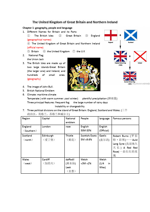
The United Kingdom of Great Britain and Northern IrelandChapter 1: geography, people and language 1. Different Names for Britain and its Parts① The British Isles ② Great Britain ③ England (geographical names)④ The United Kingdom of Great Britain and Northern Ireland (official name)⑤ Britain ⑥ the United Kingdom ⑦ the U.K 2. National Flagthe Union Jack3. The British Isles are made up oftwo large islands-Great Britain (the larger one) and Ireland, and hundreds of small ones. (geography)4. The image of John Bull.5. British National Emblem6. Climate: maritime climateTemperate ( with warm summer ,cool winter) plentiful precipitation (降雨量) Three principal features: frequent fog the large number of rainy days Instability or changeability7. Three political divisions on the island of Great Britain: England, Scotland and Wales. (三个政治区:英格兰、苏格兰和威尔士) Region Capital National emblem People language Famous personsEngland(Southern ) London rose English 50M 83%English (Official)Scotland (north )Edinburgh (爱丁堡)Thistle (蓟花)Scottish/Scots 5M <9.6% Gaelic (盖尔语)Robert Burns (罗伯特·彭斯)——Auld Lang Syne (友谊地久天长) A Red Red Rose(一朵红红的玫瑰 Wales(west ) Cardiff(加的夫)daffodil (黄水仙) Leek(韭葱)Welsh <3M <2%Welsh (1/4 in Wles)Northern Ireland Belfast(贝尔法斯特)Shamrock(三叶草)Northern Irish1.7M 1.8%English William Butler Yeats(威廉·巴特勒·叶芝)——When youare oldJames Joyce(詹姆斯·乔伊斯)——stream-of-consciousness(意识流)George Bernard Shaw(乔治·萧伯纳)Other people:3%(immigrants)补充:(1)Englandis the largest, most populous and most wealthiest part of the country.The River Thames originates in southwestern England. (英国第二长河)(2) Scotlandhas three natural zones (the Highlands in the north; the Central lowlands; the south Uplands) Capital: Edinburgh 苏格兰位于大不列颠的北部。
芬兰旅游景点介绍英语PPT

Water
Finland is honored as the ThousandIsland country(千岛之国)and the Thousand-Lake country(千湖之国).
It has 187,888 lakes and 179,584 islands. The longest river is Kemijoki, it has 550 kilometres. And Saimaa,the is the 5th largest lake in Europe.
Reasons:1.The movement of iceberg 2.The global warming
A country with thousands of lakes 千湖之国
climate
Finland belong to temperate maritime climate(温 带海洋性气候). Most parts of the country due to the influence of the north Atlantic current(北大西洋暖流 ). Finland's climate compared with other areas of the same latitude is much mild . A quarter of Finland's territory lies above the Arctic Circle, and as a consequence the midnight sun can be experienced — for more and more days, the further up north one comes. At Finland's northernmost point, the sun does not set for 73 days during summer, and does not rise at all for 51 days in winter.
Geography(美国地理)

Geography(美国地理)I. Location and Size1.What is the full name of the United States?United States of America. Often we call it the United States, the U.S., U.S.A., or America.2.What is the geographical location of the US?2.1 The continental United StatesThe continental United States lies in central North America with Canada to its north, Mexico and the Gulf of Mexico to its south, the Atlantic Ocean to its east and the Pacific Ocean to its west.2.2 The 2 newest states Alaska and Hawaii are separated from continental United States:Alaska borders on northwestern Canada, andHawaii lies in the central Pacific.3.What are the advantages of the location of the US?The US has an ideal location for its development.3.1 Its Atlantic coast faces the developed countries of Western Europe, and its Pacific coast and Hawaii give the nation an approach to the Far East and Australasia(澳大拉西亚,一般指澳大利亚、新西兰及附近南太平洋诸岛,有时也泛指大洋洲Oceania和太平洋岛屿)3.2 In the past the Atlantic and Pacific Oceans served as natural barriers between the US and the rest of the world. This allowed the US to grow and become strong with little outside interference. And today the development of means of communication and transportation makes the US well connected to the rest of the world.4.What is the size of the US?4.1 What is the size of the US?The US has a land area of 9.3 million square kilometers. It stretches 2,575 kilometres from north to south and 4,500 kilometres from east to west.4.2 How large is the US compared with the other countries?It is the 4th largest country in the world in size after Russia, Canada and China.4.3 How many states are there in the US?The US is a federal republic with many states. All together there are 50 states in the US.4.4 Which are the 2 newest states in US (the 49th and 50th states)?For a long time there were 48 states, then in 1959 Alaska and Hawaii became the 49th and 50th states.4.5 What do you know about the largest and smallest states in the US?Of all the states Alaska is the largest in area and Rhode Island the smallest.But on the mainland Texas is the largest state of the country. Texas alone is larger than France and Alaska is twice as big as Texas.II. Topography---The Face of the Land1.MountainsThere are 2 major mountains in the US: The Appalachian Mountains and the Rocky Mountains. 1.1The Appalachian Mountains1.1.1 The Appalachian Mountains run slightly from the northeast to southwest.1.1.2 The Appalachians are old (have been worn out over millions of years) and low (the highest peak is only a little over 2,000 metres).1.1.3 The Appalachians are noted for virgin forests and mines.1.1.4 The mountains served as a natural barrier for westward movement during the early settlement.1.2The Rocky Mountains1.2.1 The Rocky Mountains run slightly from the northwest to southeast.1.2.2 The Rockies are younger (are considered as young as China’s Himalayas) and high (with the higher peak Elbert of about 4,500 metres)1.2.3 The Rockies serves as the backbone of the North American continent and is known as the Continental Divide.1.2.4 The Mountains are famous for lots of natural national parks, such as the Yellow Stone Park.2.Rivers and Lakes2.1RiversThe rivers in the country are mainly lying between the Appalachian and Rocky Mountains.2.1.1The Mississippi2.1.1.1 The Mississippi is 3,782 kilometres long.2.1.1.2 The Mississippi and its tributaries drain one of the richest farm areas in the world.2.1.1.3 They form a 19,000-kilometre system of waterways and serve as important means of transportation.2.1.1.4 The Mississippi has been called “father of waters”and the “old man river”.2.1.2The Missouri2.1.2.1 The Missouri is over 6,000 kilometres and is one of the longest rivers in the world.2.1.2.2 It runs 3,725 kilometres before it joins the Mississippi.2.1.3The Ohio2.1.3.1 It is about 1,500 kilometres long.2.1.3.2 It has been called the American Ruhr (after the Ruhr River鲁尔河in Germany), famous for its rich valuable deposits.2.1.3.3 The area is well known for its steel industry.2.1.4 On the Pacific side there are 2 great rivers: the Colorado in the south, and the Columbia rises in Canada.2.1.5The Hudson2.2Lakes2.2.1 The most important lakes in the US are the Great Lakes, which include2.2.1.1 Lake Superior苏必利尔湖:the largest fresh water lake in the world.2.2.1.2 Lake Michigan密歇根湖:the only one entirely in the US2.2.1.3 Lake Huron休伦湖2.2.1.4 Lake Erie伊利湖2.2.1.5 Lake Ontario安大略湖They are all located between Canada and the US except Lake Michigan.2.2.2 What are the benefits of the lakes, rivers and seacoasts of the US?The Lakes and rivers form a complete system of waterways which provides cheap transportation for materials. Many swift rivers provide good sources of hydroelectric power. The long and irregular seacoasts provide many excellent harbours.III. Climate1.What is the general climatic feature of the US?1.1 The US is located in the middle latitudes north of the equator.1.2 Owing to its location in the northern temperate zone, generally speaking the large part of US enjoys continental climate.2. What are the different types of climate in the US?2.1 Why are the climate varied in the US?There are different types of climate in the US owing to its large size and varied landforms.2.2 What are the different types of climate in different regions?2.2.1 Continental climateA humid continental climate in the northeastern part of the country (New England).Summer is long and hot, while winter is cold. Plenty of rainfall and a long growing season.2.2.2 Humid subtropical climateIn the South-eastern United States you can find a humid subtropical climate. The summers are hot and winters mild.2.2.3 Humid continental and humid subtropical climateThis could be found in the central part of the US. You can also find the continental steppe climate of the Great Plains and the continental desert climate of the intermountain region.2.2.4 Maritime climateThe Pacific Northwest is favored with a maritime climate.The southern part of the Pacific coast in California has a Mediterranean climate with warm, dry summers and moist winters.IV. Geographical RegionsFrom the east to the west the United States can be divided into 7 geographic regions.They are New England, the Middle Atlantic states, the Midwest, the South, the Great Plains, the American West (or Rockies and Intermountain region), the Pacific Coast and the New States. 1.New England1.1 New England is made up of 6 states of the Northeast. They are Maine缅因州, New Hampshire新罕布什尔, Vermont佛蒙特, Massachusetts摩萨诸塞, Rhode Island罗得岛, and Connecticut康涅狄格.1.2 Dairying is the most important farm activity.Much of the land is mountainous or hilly, and the soil is generally thin and rock. Because of its stony soil it is not noted for its agriculture.1.3 The birthplace of America1.3.1 It was the earliest place to be settled by the early settlers from England.1.3.2 It was the chief center of the American War of Independence of 1776.1.3.3 It was also the nation’s first industrial area1.4 New England is also well known for its position in education.Many famous universities and colleges such Yale, Harvard, the Massachusetts Institute of Technology (MIT) are located here.1.5 New Englanders were originally known as Yankees北方佬, which came to stand for all Americans.2.The Middle Atlantic states2.1 The Middle Atlantic states are New, Pennsylvania, New Jersey, Delaware, Marylan, and West Virginia.2.2 It is a highly industrialized area and the nerve center of the country.2.3 The nation’s capital city Washington D.C. locates here.2.4 The area is famous for its financial, manufacturing.3.The Midwest3.1 it includes 12 states.3.2 The states lie in the northern part of the United States. In the early days the Appalachian Mountains were difficult to cross. Later when the explorers did cross them, they called the area the West. So this northern part came to be called the Midwest.3.3 It is a major manufacturing region and the nation’s leading center of heavy industry.4.The American South4.1 it includes 13 states.4.2 Because of the abundant rainfall and fertile soil of the Mississippi Lowland, agriculture was for long the chief occupation of the south.4.3 Most of the South is in a humid subtropical climate. The climate has also made parts of the South leading vacation resorts. This is particular in Florida (the sun belt).4.4 The South is rich in mineral resources. It is one of the richest oil-producing regions in the world.5.The Great Plains5.1 Livestock raising is the chief occupation here.5.2 Mining and industry are becoming important in the area because of the raw materials located there.6.The Rocky Mountains (west to the Great Plains)6.1 Much of the area is too mountainous for grazing, and very little of it is usable farmland.6.2 Mining is the chief industry in the Rocky Mountains.6.3 Another important industry of the Rockies is the tourist trade. You can find lots of national parks here, such as the famous tourist attractions of Yellowstone National Park, Glacier National Park.7.The Pacific Coast7.1 It is characterized by a series of mountain ranges and fertile river valleys.7.2 Fruits and vegetables are grown in large amounts.7.3 It is important for mineral and forest resources.8.The 2 new states8.1AlaskaInuit因纽特人,often call Eskimos.8.2HawaiiTourism is Hawaii’s most important industry.□。
Turkey土耳其介绍-PPT

Introduction
National Flag
National National Anthem Flower
National Food
fKorkma, sönmez bu şafaklarda yüzen al sancak; Sönmeden yurdumun üstünde tüten en son ocak. O benim milletimin yıldızıdır, parlayacak, O benimdir, o benim milletimindir ancak. Çatma, kurban olayım, çehreni ey nazlı hilal! Kahraman ırkıma bir gül! Ne bu şiddet, bu celal? Sana olmaz dökülen kanlarımız sonra helal...
Turkey’s wedding
Turkey’s funeral
Spots
Hospitality
Spots
Kalkan
Kalkan is a beautiful resort, located in the turquoise coast of Turkey. There is an active KAPSA tourist destination with cat protection team. KAPSA was founded in 2008, a locals’ and foreigners’ protection spontaneous organization of stray cats. Its members to make cat sterilization and provide basic health care, and then release them. Animal lovers often give up vacation time to help stray cats and KAPSA Facebook group to share their experiences and the photos.
埃及英语介绍

埃及金字塔
• 金字塔是古埃及文明的代表作,是埃及国
家的象征,是埃及人民的骄傲。 • 埃及古代奴隶社会的方锥形帝王陵墓。 • 世界八大建筑奇迹之一。数量众多,分布 广泛。
Pyramid is representative of the ancient Egyptian civilization, is the national symbol of Egypt, is the pride of the people of egypt. Square taper ancient Egyptian slave society of imperial mausoleum. One of the eight wonders of the world building. Large quantity, wide distribution
•
埃及传统节日
新年------------------------------------------1月1 日 独立日---------------------------------------2月28日 穆罕默德诞辰-------------------------------3月12日 西奈解放日----------------------------------4月25日 五月节----------------------------------------5月1日 国庆日----------------------------------------7月23日 斋戒月----------------------------------------9月 建军节(回教庆典日)-----------------------10月6日 斋戒结束欢庆-------------------------------10月1-3日 朝圣日---------------------------------------12月10-13日
Mark Twain mirror of America

1.1 Noel Grove and the Natioal Geographic magazine 1.2 Mark Twain and America (title) Objectives are: * To decode the title * To grasp the main idea of the text * To understand the structural organization
Writer
The Adventures of Tom Sawyer The Adventures of Huckleberry Fin
Mark Twain's experiences & American historical events
• • • • • • • 1853-57 1857-61 1861 1861-62 1862-65 1866-67 1869
My profile
Advanced English
Third edition book one lesson six
Mark Twain--Mirror of America
Noel Grove from National Georaphic, Sep. 1975
Content & Objectives
Criticism
• A realist • Dealt largely with the lower strata of society • Famous for his theories of localism and colloquial(方言的) style • Influenced Sherwood Anderson, Ernest Hemingway, J. D. Salinger and etc. • William Faulkner called Twain "the father of American literature"
英语词汇库{英语专题分类词汇(地理Geography)}
戈洛博翻译-英语词汇库英语专题分类词汇(地理Geography)1.GeneralTerms一般词汇:physicalgeography自然地理;economicgeography经济地理;geopolitics地理政治论;geology地理学;ethnography民族志;cosmography宇宙志;cosmology宇宙论;toponymy地名学;oceanography海洋学;meteorology气象学;orography山志学;hydroaraphy水文学;vegetation植被;relief地形/地貌;climate气候;earth地球/大地;Universe/cosmos 宇宙;world世界;globe地球仪;earth/globe地壳;continent大陆;terrafirma陆地;coast海岸;archipelago群岛;peninsula半岛;island岛;plain平原;valley谷地;meadow(小)草原;prairie(大)草原;lake湖泊;pond池塘;marsh/bog/swamp沼泽;smalllake小湖;lagoon泻湖;moor/moorland荒原;desert沙漠;dune沙丘;oasis绿洲;savanna(南美)大草原;virginforest原始森林;steppe大草原;tundra冻原。
2.Cartography地图绘制法:map地图;mapoftheworld世界地图;planisphere平面地形图;wallmap/skeletonmap挂图;skeletonmap示意图;map/plan/chart平面图;atlas地图集;chart海图;cadastre地籍薄;topography测绘学;photogrammetry摄影测量学;worldpolitical世界政区;worldphysical世界地形;worldcommunication世界交通;worldtimezone世界时区;geomorphy地貌;scale比例尺;legend图例;citymap城市图;populatedlocalitied居民点;capital首都/首府;capitaloffirst-orderpoliticalunit一级行政中心;maincity/majorcity主要城市;commoncity一般城市;village村;town镇/乡;city boundary市界;boundary境界;continentalboundary洲界;internationalboundary国界;undefinedinternationalboundary未定国界;regionalboundary地区界;boundaryorfirst-orderpoliticalunit一级政区界;communication交通;railroad/railway铁路;expressway/motorway高速公路;highway公路;shippingroute航海线;airport机场;port港口;streamsystem水系;river河流;waterfall瀑布;saltlake咸水湖/盐湖;lake湖泊;seasonallake时令湖;seasonalriver时令河;reservoir水库;dam水坝;waterpipeline输水管;well井;spring泉;hotspring温泉;swamp沼泽;desert沙漠;peak山峰;volcano火山;coralreefs珊瑚礁;historicsite古迹;pass山口/关隘;thegreatwall长城;pyramid金字塔;magneticpole地磁极;cityblocks城市街区;mainstreet/majorstreet主要街道;secondarystreet次要街道;importantbuilding重要建筑物;building独立建筑;collegeoruniversity高等院校;nationalpark国家公园;militaryinstallation军用设施;spacecentreorscientificresearchcentre航天或科研中心;lighthouse灯塔;monument纪念碑;stadium体育场;gymnasium体育馆;park公园;bridge桥梁;greenland绿地;cemetery墓地。
瑞士的英文介绍
洛桑 日内瓦 日内瓦
联合国粮食及农业组织 (Food and Agriculture Organization) FAO “粮农组织”
国际货币基金组织 (International Monetary Fund) IMF
联合国儿童基金会 (United Nations Children‘s Fund) UNICEF
Switzerland ,officially the Swiss Confederation , is a federal republic consisting of 26 cantons. It is situated in Western Europe and is a landlocked country whose territory is
政治
1815年维也纳会议承认为永久中立国。目前还没 有加入欧盟。由于其中立国的地位,是许多全球 性组织的总部所在地
• 瑞士联邦委员会是瑞士的国家最高行政机关,包
括七名委员,他们在惯例上轮流担任瑞士联邦总 统。他们在法理上共同组成瑞士的国家元首,联 邦委员是由联邦国会中的两议院共同选出,每一 届任期为四年。
整个国家的领土被侏罗纪,高原, 阿尔卑斯山脉三种地形地理分割。 国境几乎都在阿尔卑斯山脉之中,所 以整个国土几乎70%被大山覆盖。
Zurich is Switzerland‘s largest city
ECONOMY
Titlis mountain(铁力士山) has the world‘s first rotating
which makes swiss a famous tourist resort in the world . It is bordered by Germany to the north, France to the west, Italy to the south, and Austria and Liechtenstein to the east. The population of Swiss mostly concentrates in Zurich and Geneva. It is hereby
magazines
4. Entertainment functions: enjoyment and relaxations
Categories of magazines
• Fashion Magazine
• • • • • Art Magazine Scientific Magazine Ezines Geographic Magazine Literary Magazine
Ezines
• They are electronic magazines obtained in website. They mainly introduce some popular issues. • Boxes and Arrows, Evolt, Webmonkey, Eurohacagazine
• It mainly presents the current affairs to the readers, but its his comments hit home compare to newspaper. • TIME, • US News and World Report, • World, • The Nation, • The Economist, • Maclean’s Magazine
Famous magazines
• Business Week • VOGUE PLAYBOY • VANITY FAIR • The New Yorker • FHM • THE FACE • ROLLINGSTONE • Forbes • PEOPLE
Functions of magazine
1. Surveillance functions (careful watch kept on someone suspected of doing wrong): provides information about the society and developments taking place
Turkey土耳其介绍 ppt课件
PPT课件
16
• Karpathos
• In the Aegean sea .It covers an area of 301 square kilometers (301 square miles). Main towns are in southern island.It is a rocky island,except south without trees.
PPT课件
8
TTurkey is surrounded by the
Mediterranean ,the Aegean,the Marmara and the
Black Seas.
PPT课件
9
Local Customs
PPT课件
10
Spots
Living in Turkey
◎Clothing
In Turkish society, because of the
PPT课件
19
Spots
Spot
End
Turkey Crafts
Scarves - women in Muslim countries
had to turban, the scarf has become their most important accessories
Famous Turkish carpets
PPT课件
17
Karpathos
You can go to the island after surfing, and watch the Mosaic and murals.
PPT课件
18
That is all. Thank you for your time. In Turkey, may all your dreams come true. Please love this country as you can!
- 1、下载文档前请自行甄别文档内容的完整性,平台不提供额外的编辑、内容补充、找答案等附加服务。
- 2、"仅部分预览"的文档,不可在线预览部分如存在完整性等问题,可反馈申请退款(可完整预览的文档不适用该条件!)。
- 3、如文档侵犯您的权益,请联系客服反馈,我们会尽快为您处理(人工客服工作时间:9:00-18:30)。
Patagonia Cowboys Cowboys on the Edge In the wilds of Patagonia, cowboys called bagualeros pit themselves against the meanest livestock on the planet. By Alexandra Fuller Photographs by Tomás Munita Tweet
This is a story about blood, courage, and tradition, and like most stories of this nature, there are horses involved, and men of unlikely skill and reticence, and yes, of course, lives and limbs are at risk. Also, like most stories of this nature, the landscape is mythically wild, partly because it is so remote and therefore almost impossible to reach by ordinary, convenient means. If you know where to look, you can see Sutherland on a topographical map, a finger of land pointing into Chile’s Última Esperanza Sound, in southern Patagonia. But there are no roads near the place, and no settlements. To the north—but again, not accessible by ordinary means—there is Torres del Paine National Park, and beyond that the wild and impassable northern ice fields that cut off Chile’s Patagonia from the rest of the country. To the west, scores of little islands make a puzzle of the southern Pacific. To the east, there is the sound—often thrown into a fury by the infamous wind here, and therefore not always safely navigable—and at last Puerto Natales, with its pleasant, touristic shops and restaurants.
Sebastián García Iglesias, a 26-year-old agricultural engineer by trade but cowboy at heart, is worn wise in the manner of one who has been raised around large animals. His legendary great-uncle, Arturo Iglesias—whom Sebastián is said to resemble to a haunting degree—was born in the town of Puerto Natales in 1919. The Iglesias family was one of the first to settle this area in 1908, setting up a general store for pioneers. Shortly after that the family established Estancia Mercedes on a piece of land nestled picturesquely against the sea, with its back to the mountains. Then, in 1960, Arturo acquired Estancia Ana María, a ranch that can be reached only by boat, or by a ten-hour horse ride if you are willing to cross a bog in which your mount will repeatedly sink up to its belly. And as if Ana María were not remote enough, Arturo created a settlement in Sutherland, a nearly unreachable area within Estancia Ana María. Once in its history, a ranch hand, his wife, and their two children lived in a little house in Sutherland, but the wife—perhaps driven mad by the isolation—ran off with a fisherman, and eventually the ranch hand and his two motherless children left and drove the cattle back to civilization.
Stragglers from Arturo’s herd turned feral and bred, natural selection making them bigger and fiercer, and every summer Arturo rounded them up, riding from Estancia Ana María with his cattle dogs and his most trusted horses. Sometimes he sent the wild cattle—baguales, they’re called, which translates as “savage livestock” rather than merely “wild”—to market in Puerto Natales by boat, and sometimes he herded them by land along knife-edge cliffs, through bogs, and over slick rocks, riding with a packhorse and a wild bull in tow, a hand-rolled cigarette perpetually pasted to his lower lip.
But now the Iglesias family—which is to say all the extended family of aunts and uncles and cousins who had little or no emotional connection to the place—had decided to sell Ana María, including Sutherland, to a wealthy cattle rancher. The rancher had given Sebastián permission to retrieve baguales on the land one final time. Accordingly, Sebastián set about finding the finest bagualeros in Puerto Natales to assist him, and perhaps in part because he hopes one day to take tourists bagualeando, and so keep the tradition alive, he allowed us to tag along.
So it was clear from the outset: This expedition to Sutherland would be no ordinary cattle drive to market. For a start, the baguales of Sutherland were baguales that hadn’t seen a rope in generations. And just to get to Sutherland, we would be riding with Sebastián and three other bagualeros, 20 horses, and 30 dogs for at least a couple of days through the kind of terrain that rewards a false step with whatever comes after life.
I phoned home for moral support. “I’ve been told to pack goggles,” I told my father. There was a brief silence. “Goggles are for invading bloody Poland, not rounding up a couple of cows,” Dad said. He’s a British-born Zambian farmer in his 70s, and he thinks nothing of plunging into the Zambezi Valley darkness to chase elephants off his bananas or scare crocodiles out of Mum’s fishponds. “What’s the object of the exercise?”