GlobalGeoparksNetwork-世界地质公园网
第06讲介词(练习)(教师版)2025年高考英语一轮复习讲练测(新教材新高考)
第06讲介词题型一介词在复杂语境中的基本用法1.(2024年广东省广州市天河区三模试题)“On that patch of grass, I could connect with living plants and animals, allowing me to refresh my mind and heal_____ the stresses of the workplace,” Huang said.【答案】from【解析】考查介词。
句意:黄说:“在草坪上,我能感到和动植物联结,让我感觉头脑清醒,从工作压力中恢复过来。
”heal from“从……康复、恢复”,固定短语。
故填from。
2.(2024年湖南省长郡中学、浙江杭州二中、江苏省南京师大附中三校联考)Sichuan Cuisine, Hunan Cuisine does not typically include the numbing sensation of Sichuan peppercorns.【答案】unlike【解析】考查介词。
句意:与川菜不同,湘菜通常不包括四川胡椒的麻木感。
根据句意可知,此处应用表示“与……不同”的介词unlike,句首单词首字母应大写。
故填Unlike。
3.(2024年江苏泰州模拟预测)“ one of the leading corporations engaged in the BRI, Dongfang Electric Corporation has been committed to sustainable, high-standard development and people’s well-being since 2012,” noted Song Zhiyuan, a director of the company.【答案】As【解析】考查介词。
句意:“作为参与‘一带一路’的领先企业之一,东方电气公司自2012年以来一直致力于可持续、高标准的发展和人民的福祉,”该公司董事宋志远表示。
世界地质公园的由来
世界地质公园的由来从地质遗迹的保护到地质公园的建立,世界地学工作者们历经了长时间的努力和奋斗:1972年联合国在瑞典首都斯德哥尔摩召开了“人类环境会议”,会后发布了“人类环境宣言”,由此拉开了世界环境保护的序幕。
同年在巴黎召开了联合国教科文组织第17届大会,通过了“世界文化和自然遗产保护公约”。
旨在各成员国将本领域内具有世界保护意义的地点纳入“世界遗产名录”,通过国际合作,对其进行保护,并成立了“世界遗产委员会”。
由此宣告全球性的自然和文化遗产保护工作启动。
至2004年底,共有177个国家成为签约国,列入名录的遗产地788个,其中文化遗产地611个。
自然遗产地154个,混合型23个。
其中有20处遗产是地质遗迹为核心保护内容而列入的,在自然文化遗产中的近百处都分布有重要地质遗迹。
世界遗产公约的宗旨是依据现代科学方法,建立一个永久性的有效制度,共同保护具有突出普遍价值的自然和文化遗产。
要求各缔约方对自然、文化遗产的辩明、保护、养育作出承诺并保证其世代传承。
世界自然遗产的定义是:①从美学和科学角度看,具有突出,普遍价值的地质和生物结构或这类结构群组成的自然面貌;②从科学或保护的角度看,具有突出或普遍价值的地质或自然地理结构以及明确划定濒危动植物种群生态区;③从科学、保护或美学角度看,具有突出普遍价值的天然名胜或明确划定的自然地带,上述定义中,地学意义的位置十分突出。
同时又进一步明确了四条辩识标准:①构成代表地球演化史中重要阶段的突出例证;②构成代表进行中的重要地质过程、生物演化过程以及人类与自然环境相互关系的突出例证;③独特称有或奇妙的自然现象、地貌或具有罕见自然美的景观地带;④尚存的珍稀或濒危动植物种群的栖息地。
这是条辩识标准更明确世界自然遗产中地学遗迹的重要性。
但是,在世界遗产名录中文化遗产占了77%。
自然遗产仅占19%,这对于广泛分布的、大量的、急需保护的地质遗迹实在是挂一漏万。
为了弥补这一不足,1989年联合国教科文组织、国际地科联(IUGS)、国际地质对比计划(IGCP)及国际自然保护联盟(IUCN)在华盛顿成立了“全球地质及古生物遗址名录”计划,目的是选择适当的地质遗址作为纳入世界遗产的候选名录。
Google Earth常用网站
Google Earth常用网站1. GoogleEarth官方 /2. google maps /3. google 地图/4. 3D Earth /5. KML文件教程 /kml/kml_tut.html6. GE资源网站汇总 /google-earth-resources.html7. Google Earth教程 /ge_new.asp8. Google Earth Community(google earth社区) /9. Google Earth 爱好者论坛 /bbs/index.php10. 上帝之眼 / (论坛)/bbs_index.asp11. Google Earth观察 /google/12. 月光论坛地标交流论坛 /forum-20-1.html13. Google Earth爱好者网站 /14. PC online 的Google Earth讨论区 /forum.jsp?fid=24041115. google earth 地标 /lianluo/66/2052066.shtml16. google earth blog /17. 一个Google Earth迷的博客/u/140016148718. google earth的图文教程汇总/ahgua/archive/2006/03/15/770120.aspx19. Google Earth Hacks /20. google sightseeing /21. Virtual Globetrotting /22. Space Image Gallery /gallery/23. Google Earth Cool Places /24. Globe Glider /blog/archives/2006/01/globe_glider_in.html25. JuicyGeography /googleearth.htm26. Digital Geography /27. GE for Geography Teachers /googleearth.htm28. Blue Point /www/29. Flying Globe /30. Google Touring /31. Google Earth Tips360 /32. ArcGISExplorer/software/arcgis/explorer/index.html33. Microsoft Mappoint /mappoint/default.mspx/mappoint/products/webservice/default.mspx34. Earth Explorer /35. 北纬29度的博客(奇妙地球区) /blog/default.asp?cateID=736. 酷秀网络 /blog/default.asp?cateID=3037. Using google earth /38. OGLE Earth /39. Google Mars /mars/40. Google Moon /41. Google Show-GE /?cat=642. 地理时间/default.asp?cateID=21/default.asp?cateID=2343. 星韵地理博客 /44. worldwatcher的博客(我的) /worldwatcher45. 新浪google earth 吧 /googleeart46. 搜狐GOOGLE EARTH吧 /47. 3D Warehouse /3dwarehouse/48. NASA的GE地标/documents/available.html49. 超强组合的Google Maps mashup:Jotle /50. WikiMapia:一个基于Google Earth的地图维基百科 /51. Earth Contest游戏 /2/index.htm52. Windows Live Local(微软地图) /?q=&FORM=BD53. 再说长江到google earth奇妙之旅 /f/edu/067/26/302593.htm54. 好学网google earth专题 /article/010/0102/list1.htm55. 如果挖洞会到哪里? /index.php?lang=en56. SightseeingwithGoogleSatelliteMaps/google-satellite-maps/57. 通过Envisat卫星实时看地球 http://miravi.eo.esa.int/en/58. Strange Google Maps /google_homepage.xml59. Google Earth Developer /ubb/ContentIslands/5_rss20.xml60. James Fee GIS Blog /61. Logamap /62. 我爱地球 /earth/63. Panoramio贴图 - Google Earth /64. 旅游博客卫星地图 /index.php?catid=365. 梦想天空 /default.asp?cateID=766. Google Mashup(综合应用)合集//67. Google Earth 应用研究/blog/group.asp?gid=268. MapOpen /69. Google Earth官方举办校园模型设计大赛 /entry.php70. Google Maps API(写程序) /apis/maps/71. 全能之眼 /72. GE War 世界大战 /73. 搜狗地图 /74. 百度地图 /#75. 微软地图 /76. AOL Maps /travel//maps-search77. (商店) /78. UT Library Online Maps Collection /maps/79. street maps /80. multimap /81. 世界地图 /Map_EarthMap.php?ID=/Cn82. 地标交流系统 /kml/top.htm?83. Google Show (GE) /?cat=684. 雅虎地图 /beta/index.php#env=U85. MapQuest /z/google/earth.html86. EarthBrowser /87. 中国卫星地图 /88. 我要地图 /89. 灵图UU /90. 图雄网 /91. 携程地图中心 /map/map.asp92. Geonomy /93. DayLightMap(全球昼夜的实时变化)/94. Tagzania 共享地图 /95. 地景空间Geoview /index.asp96. UFO专题地图 /97. Mapabc图盟 /98. 小me地图 /99. E都市 /100. 都市圈 /101. 地图联盟 /down/freemap/freemap.jsp102. Go2 Map图行天下 /103. China3view 三味中国(51地图与google地图结合) /51-gmap.htm# /chindex.htm104. 城市吧 /105. Gbulo--Google爱好者社区 /forumdisplay.php?fid=8106. 地圖漫步网站 /janson1986/default.html107. 搜索引擎周边GE专区/catalog.asp?tags=google-earth108. ChinBeta中文搜索引擎IT资讯—GOOGLE专区 /blog/default.asp?cateID=9 109. 图书里集成GOOGLE MAPS /2007/01/books-mapped.html110. NaviTraveler发现和分享,关于旅行及生活的一切 /search.php111. 圣经地图 /112. 婚礼地图 /113. GIS第一站 /giser/index.html114. GIS海洋 /115. 奇虎google earth专题 /site/it/zhuanti/googlearth/116. 巧巧读书google earth专题 /z/google/earth.html117. Swivel:GIS以及各种统计数据的宝库 /118. Mapedit软件 /mapedit/119. USGS(地质) /120. NOAA(海洋) /121. Digital Globe /122. ESRI /123. Google Blogoscoped /124. 谷歌治印 /125. 国家地理地图区 /mapmachine/index.html126. Google Maps API blog中文 /127. Google Maps API2文档中文/doc/maps/documentation/128. UNEP全球环保地图 /digital_atlas2/google.php129. 地方客 /130. 三大公司地图一起看/131. EEmap /132. Earth at night 地球之夜/~pesti/night/133. Google Maps Europa 木卫一卫星图 |/~pesti/europa/ 134. NEWSMAP 新闻地图/135. 在地图上画烟雾 /en/send136. 南极探索 /ngm/antarctica/index.html137. HousingMaps(第一个Google Earth Mashup) /138. Flickr 的一个专题/photos/gisuser/sets/1075031/139. 360度可缩放实景地图/index.html140. Agent Earth:搜索地名即直接生成Google Earth地标文件 / 141. Trulia是美国一家房地产搜索网站基于Google Maps API /142. GE Mashup /modules.php?name=News&file=article&sid=18029 143. Google earth 中文在线版 /map/144. Google Earth fan(法语) http://google.earth.fan.free.fr/145. Flash Earth /146. A9 Map /147. Global Mapper /148. Mapxy /locs/mapit.html149. 微软澳大利亚航拍活动.au/what_map.aspx150. 开飞机 /games/goggles.html151. 用地图问好 /152. 中国卫星地图网 /map/index.htm153. 中国经纬度确定系统 /artical/bbs/gm_index.asp154. 地图小镇 /155. 无忧地图 /156. 中搜地图 /157. sitemap网站地图制作工具 /sitemap/158. 地图网站全集 /free/ditu.htm159. 通查卫星地图 /fmap.htm160. 找路/ 找路世界地图/emap.php中国地图 /china_emap.htm 161. 山东卫星地图 /weixing.asp162. 我爱地图 /163. 卫片快车 /wpkc/index.html164. 标示卫星地图位置 /map_zh.php165. 大中国地区城市google map卫星地图 /gmap/166. Urmap你的地图网繁体/、167. 相约久久卫星地图 /168. 美国著名的科学组织AAAS科学与人权”的项目(采用卫星图片来记录极端暴力事件) /169. 德国的地图软件smart2go /en/index_html170. google earth api中文教程网站 /171. google maps API Blog /172. 鸣沙的空间关于google earth 的内容 /sys/search?type=0&sort=1&entry=1®ion=2&hi=sofeng&word=Google+Earth 173. Google Earth Online 普通模式 /map/174. Earth Explorer /download.htm175. USA Photo Maps /176. 我的中国地图2007 /177. google研究院/default.asp?cateID=7178. 地图的发现 /yanglang/179. 中国电子地图网 /180. 逛网-地图查询 /map.htm181. Travel Map Super Link /map182. 地图总会 /f/hotweb/057/29/151007.htm183. 地图搜索引擎 /SEARCH/maps_search.htm184. 中文搜索指南GE专题 /Google%20Earth/index.htm185. 搜索爱好者论坛-GOOGLE EARTH /forumdisplay.php?fid=36186. 地图之窗 /187. 香港地图 /188. 搜狐旅游电子地图 /map.php189. 爱问本地 /190. 中华地图网 /191. 丁丁地图 /mstmap50007/index.jsp192. 中国豪宅之窗的地图 /193. 地图索引/map/194. 百度空间google earth专题 /wxdt195. 活图网 - 神州龙地图(新版)/196. 神州龙地图(旧版)/index.asp197. TOM在线地图 /198. Windows Live Local的驾驶模式 / 199. 微软卫星地图 /200. Yahoo卫星图/201. 可以在线标注地名的Earth卫星地图/ 202. ESRI 中国 /index.htm203. GeoCaching /204. route 66 /route66/homepage.php?cid=CN-md 205. GPS 交流论坛 /index.php206. 社交中心/207. 计算你旅行的行程或者折扣 / 208. 查看世界各地的时间 /time/gmaps?map=1 209. 分享地球各地资讯 [英文] /210. 测量地区面积 /planimeter211. 使用任何地图定制自己的Google maps / 212. 在地图上贴上自己的项目 /213. 查看地球下面的情景/sandwich/tool.html 214. 在美国找人 /215. 检查各地天气 /216. 寻找附近星巴克 /coffee_s.html217. 发现Ebay房地产交易情况 /218. 寻找美国或者英国机场的停车场 / /airporthotels 219. 创建活动线路 /220. 观看旅行录像 /221. 在美国寻找快餐店 /fastfood/food.php222. 翻译美国邮政编码 /zip.htm223. 通过邮编查看本地新闻 /localnews/index.html224. 了解交通状况 /google-yahoo/225. 了解和避免疫情 /226. 做出自己mashup地图 /227. 避免交警探头 /us.html228. 寻找廉价加油站 /229. 检查日落或者日出时间 /230. 货币兑换 /currency.php231. Mapion(日文)www.mapion.co.jp/232. MapFan Web /233. GPSVisualizer - tracks and maps (free) - Excellent resource, support GE output234. Magnalox - tracks, maps, and more, supports GE (free)235. RoboGEO - tracks and photos, supports GE (commercial)236. Motionbased - tracks, graphs, sports-oriented, supports GE (free, subscription)237. Leonardo Paragliding Database - Supports GE output (free)238. Storm Tracking Tools239. My Katrina Articles240. Fun & Games Forum at GEC241. GoogleEarthing - find the spot pictured in GE242. 杨•阿尔蒂斯-贝特朗(Yann Arthus-Bertrand)航拍地球/ /yann.htm /243. 中国航拍网/244. GIS开发者网络 /245. 九游地图频道/Wiki_Map/246. 航拍墨西哥 /helipilot/PhotoAlbum31.html247. 新浪——天文地理,软件下载 /download/d_list.php?page=1&limit=15&f_categoryid=155&sort=menddate欢迎您的下载,资料仅供参考!致力为企业和个人提供合同协议,策划案计划书,学习资料等等打造全网一站式需求。
第八届联合国教科文组织世界地质公园国际大会
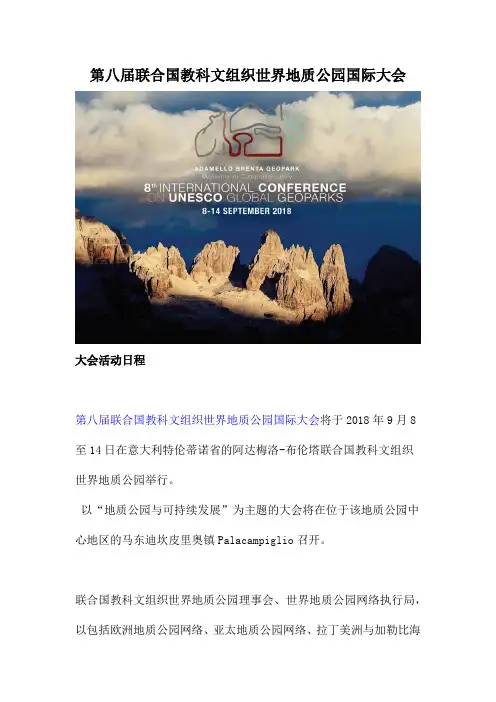
第八届联合国教科文组织世界地质公园国际大会大会活动日程第八届联合国教科文组织世界地质公园国际大会将于2018年9月8至14日在意大利特伦蒂诺省的阿达梅洛-布伦塔联合国教科文组织世界地质公园举行。
以“地质公园与可持续发展”为主题的大会将在位于该地质公园中心地区的马东迪坎皮里奥镇Palacampiglio召开。
联合国教科文组织世界地质公园理事会、世界地质公园网络执行局,以包括欧洲地质公园网络、亚太地质公园网络、拉丁美洲与加勒比海地质公园网络等区域网络的谘询委员会及协调委员会将在大会进行之前的9月8至10日期间举行会议。
大会则会在9 月11日紧随揭幕仪式及主题演讲正式开始。
9 月11及12日的会议将举行5个分专题讨论,同时还会与世界地质公园网络有关工作小组合办特别研习班。
世界地质公园网络顾问委员会及网络大会也会同期举行。
在活动的第三天,即9 月13日,大会将安排实地考察,参会者可在六个选项中作出选择,借机认识及体验阿达梅洛-布伦塔联合国教科文组织世界地质公园的地质、自然及文化特色。
在当日行程结束后的盛大晚宴上,将同时举行新成员证书及世界地质公园网络奖项颁授典礼。
9 月14日的第四天会议继续举行5个分专题讨论。
特别研习班将与相关的世界地质公园网络工作小组合办,此外还会举行世界地质公园网络最佳实践奖颁奖环节。
大会闭幕仪式会在同一天举行,并同时颁发世界地质公园网络再评估证书及宣布第九届联合国教科文组织世界地质公园国际大会事宜。
大会已计划在期间展开一系列社交及文化活动,让参与者有机会接触当地人及其传统,以及意大利人的生活方式。
此外,地球博览会将提供充足空间,向全球逾800名代表团成员展示及宣传有关地区及联合国教科文组织世界地质公园,以及其服务、活动和特有产物。
与世界地质公园网络工作小组合办的联合国教科文组织世界地质公园非物质文化遗产展览将在大会的会议中心展出。
大会在9 月11至14日期间为代表团的随行人员(包括伙伴、家属和朋友)安排特别节目,包括游览、活动及导赏团,以全面体验和探索阿达梅洛-布伦塔联合国教科文组织世界地质公园。
北京·周口店——地质公园概念诞生地
25化 石2021年 第1期经典回放北京•周口店——地质公园概念诞生地吕金波许多以“化石”为特色的自然遗址建成了地质公园。
截止2020年,联合国教科文组织支持的世界地质公园网络(Global Geoparks Network )共有161个成员,中国有41个成员,其中北京周口店是地质公园(Geopark )概念的诞生地,日期应该是1996年8月10日。
第30届国际地质大会会间T 203周口店遗址考察路线根据《第三十届国际地质大会地质旅行委员会旅行路线总结及文献选编》记录:第30届国际地质大会会间地质旅行路线中的《T 203北京周口店古人类遗址及第四纪洞穴地质(第四纪、地貌、古人类)》考察了周口店北京人遗址。
时间为1996年8月10日(星期六)。
领队:徐钦琦(中国科学院古脊椎动物与古人类研究所)和田明中(中国地质大学),副领队:李龙吟(中国地质大学),领队人员还有刘金毅(中国科学院古脊椎动物与古人类研究所)。
登记的考察人员43人如下:Men n i ng Ma n f red (德国),Ha r i ng ton C.R .(加拿大),Farr Jone (美国),Ramberg Ivar B .(挪威),Shibata Matsutaro (日本),Milici Robert C.(美国),Usui Akira (日本),Klingberg Fredrik (瑞典),Watanabe Koichiro (日本),Wei Kuo Yen (中国台湾),Goto Masatoshi (日本),Kennett James P .(美国),Gaigalas Algirdas (立陶宛),Branagan David F .(澳大利亚),Aoki Saburo (日本),Passe Tore (瑞典),PidgeonRobert T .(澳大利亚),Beckers Eliane (比利时),Knight Michael J .(澳大利亚),Harper Stephen B .(美国),Kimula Sadako Masaaki (日本),Geissler Eckark (德国),Takeuchi Sadako (日本),Shi Zhiqun (澳大利亚),Hoefling Richard (德国),Curtis Garniss (美国),Juve Gunnar (挪威),Schretzenmayr Stephan (德国),Anclam Peter (德国),Schnabel Georg Wolfgang (奥地利),Janoschek Werner R .(奥地利),Wells Roderick (澳大利亚),Findlay Christopher (加拿大),O ’Hara Sakae (日本),Shiba Masahiro (日本),Harris Sara (美国),Sampurno (印度尼西亚),Wopfner Helmut (奥地利),Komarower Pat r icia (澳大利亚),Tu nis Giorgio (意大利),Pidgeon Robert T .(澳大利亚),Franklin James (加拿大),Nicholas Shackleton (英国),等等。
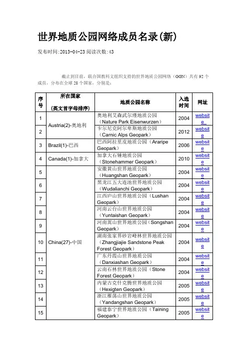
世界地质公园网络成员名录
website
23
江西龙虎山世界地质公园(Longhushan Geopark)
2008
website
24
四川自贡世界地质公园(Zigong Geopark)
2008
website
25
内蒙古阿拉善沙漠世界地质公园(Alxa Desert Geopark)
2009
website
26
陕西秦岭终南山世界地质公园(Zhongnanshan Geopark)
43
德国布朗斯韦尔地质公园(Geopark Harz Braunschweiger Land Ostfalen)
2005
website
44
Germany/Portland(1)-德国、波兰
马斯喀拱形地质公园(Geopark Muskau Arch)
2011
45
Greece(4)-希腊
希腊莱斯沃斯石化森林地质公园(Petrified Forest of Lesvos)
2010
website
62
意大利图斯卡采矿公园(Tuscan Mining Park)
2010
website
63
阿普安阿尔卑斯山地质公园(Apuan Alps Geopark)
2011
website
64
Japan(5)-日本
洞爷火山口和有珠火山地质公园(Lake Toya and Mt. Usu Geopark)
2004
website
9
河南嵩山世界地质公园(Songshan Geopark)
2004
website
10
湖南张家界砂岩峰林世界地质公园(Zhangjiajie Sandstone Peak Forest Geopark)
世界地质公园中评估流程
世界地质公园中评估流程
评估世界地质公园的流程通常包括以下几个步骤:
1. 提名:地方政府或相关利益相关者提名一个地区作为世界地质公园。
提名需要满足世界地质公园网络(Global Geoparks Network)的标准和条件。
2. 预评估:提名地区需要进行预评估,以确定是否满足世界地质公园网络的标准和条件。
预评估通常由国家或地区的地质学专家进行。
3. 申请:如果预评估结果符合要求,提名地区可以正式提交申请成为世界地质公园。
申请包括详细的申请表格和支撑材料,如地质报告、运营计划等。
4. 评估:申请地区会接受国际专家组的评估。
评估通常包括实地考察、文件审查和与当地相关利益相关者的讨论。
评估专家将根据世界地质公园网络的标准和条件,对申请地区的地质、自然、文化和社会价值进行评估。
5. 决策:评估结果将交由世界地质公园网络理事会审议和决策。
理事会会考虑专家评估报告、申请地区的管理能力和可持续发展规划等因素,最终决定是否授予申请地区世界地质公园的地位。
6. 批准和登记:如果申请地区成功通过评估并获得世界地质公园地位,会得到正式的批准和登记。
相关机构将颁发证书,并
将该地区列入世界地质公园网络的名录中。
7. 管理和监测:一旦成为世界地质公园,申请地区需要制定和执行管理计划,并进行定期的监测和评估。
这样可以确保地质公园的自然和文化价值得到保护,并支持可持续的旅游和社区发展。
需要注意的是,每个地区的评估流程可能会有所不同,具体的步骤和要求可能会有所调整。
安特生对中国宣龙式铁矿床发现、考古学和地质学的三大贡献
安特生对中国宣龙式铁矿床发现、考古学和地质学的三大贡献吕金波经典回放1914年至1926年,瑞典人安特生(JohanGunnar Andersson)受聘中国北洋政府农商部矿务顾问,对中国作出过三大贡献——宣龙式铁矿床的发现、考古学和地质学。
1921年10月27日~12月1日,安特生在中国地质学家袁复礼、刘长山、陈德广、白万玉、姚氏、张氏等人的陪同下发现仰韶文化遗址、开创了中国田野考古学。
迄今百年,写文纪念。
1902年,安特生毕业于瑞典乌普萨拉大学(Uppsala Universitet),获地质学博士学位,后来编写了《世界铁矿资源》和《世界煤矿资源》两本调查集,任万国地质学会秘书长,举世瞩目,受到了北洋政府的关注。
1913年北洋政府成立了农商部地质调查所和地质研究所,1914年聘请安特生担任农商部矿务顾问,发现龙关(1958年12月龙关县与赤城县合并、1960年5月改称赤城县)铁矿,1915年受到袁世凯的接见(谈话时间长达2小时),1916年黎元洪总统颁发“总统三等嘉禾章”奖励,这一时期安特生编写了《中国的铁矿和铁矿工业》和《华北马兰台地》两部调查报告。
发现宣龙式铁矿床安特生顾问于1914年发现龙关县赤铁矿,在1918年发现宣化北面的烟筒山赤铁矿,后来被地质教科书和《地球科学大辞典》定义为“宣龙式铁矿床”。
赤铁矿赋存于龙关县和宣化烟筒山一带的中元古代长城纪串岭沟组下部。
这一发现奠定了1919年6月开工、9月成立“龙烟铁矿股份有限公司”的基础,解放后发展成为“首钢”和“宣钢”两大钢铁基地。
发现过程1914年,北洋政府聘请安特生为农商部矿务顾问。
恰逢第一次世界大战爆发,钢铁产量成为战胜国的标志,人们希望找到大量的铁矿,北农商部矿务顾问——瑞典人安特生洋政府想找到由中国人自己掌控的铁矿山。
安特生来到中国后的第一个贡献就是在1914~1918年先后发现龙关县——宣化烟筒山的赤铁矿,1919年9月成立了“龙烟铁矿股份有限公司”,现在首钢厂内的石景山半山腰还保留有“龙烟专家楼”遗址,两排青石砌筑的平房,是建厂时帮助安装第一座250吨炼铁炉的美国工程师格林(G. G. Green)的起居室和办公室,当时称为“龙烟别墅”,是在古代法明寺旧址上修建的。
世界地质公园申报流程
世界地质公园申报流程英文回答:Application Process for World Geoparks.The UNESCO Global Geoparks Network is a network of geological sites of international significance designated by UNESCO. The process of applying for a UNESCO Global Geopark involves the following steps:1. Identification: The first step is to identify a potential geopark site. The site should have a unique geological heritage of international significance, as well as cultural and natural values.2. Preparation of a nomination dossier: The nomination dossier should provide a detailed description of the geopark site, including its geological heritage, cultural and natural values, and management plan.3. Submission of the nomination dossier: The nomination dossier should be submitted to UNESCO through the national geological survey or relevant government agency.4. Evaluation: The nomination dossier will be evaluated by a panel of experts from UNESCO. The panel will assessthe site's geological heritage, cultural and natural values, and management plan.5. Designation: If the nomination dossier is approved, the site will be designated as a UNESCO Global Geopark.中文回答:世界地质公园申报流程。
国家地质公园与联合国教科文组织世界地质公园的异同点分析
第6 7卷 第2期2 0 2 1年3月地质论评GEOLOGICAL REVIEW V〇l.67 No.2Mar.,2021国家地质公园与联合国教科文组织世界地质公园的异同点分析张建平中国地质大学(北京)地质遗迹研究中心,北京,100083W W W. /georev内容提要:地质公园作为21世纪兴起的新生事物,它把地质遗迹资源作为一种特殊类哦的自然资源加以保护 和利用,是人类合理利用地球资源的一项创举,在地质遗迹保护、科学知识传播和区域可持续发展中发挥丫重要的 作用:在中国,地质公园有三个类型:省级地质公园、国家地质公园和教科文组织世界地质公园它们之间既有密 切的关联,又各具特征,在理念、管理、标准、和发展目标等方面,存在一定的相似性,但又有明显的差异:对这些异同 点认识上的不足导致在过去20年的地质公园发展过程中,产生了许多问题本文从分析中国国家地质公园和教科 文组织世界地质公园的异同点出发,指出其产生的历史和观念上原因,并给出可能的解决方案关键词:中国国家地质公园;世界地质公园;异同点;对比分析1背景(Background)我国是国际上最早建立地质公园的国家之一, 2000年开始创立国家地质公园随后,参照国家地 质公园的标准和管理,结合本行政区的实际情况,许 多省级行政区在其范围内设立了省级地质公园,到 2019年,已陆续建立了 220多家国家地质公园和大 批省级地质公园。
地质公园在中国的设立,以保护 珍贵的地质遗迹为己任,性质上属保护区,颁布的•系列管理方法和措施与之相对应,使我国许多珍贵 的地质遗迹产地得到了有效的保护和管理(张建 平,2020a),也为我国世界地质公园的建设提供了坚 实的基础。
鉴于中国国家地质公园(以下简称国家 地质公园)与教科文组织世界地质公园(以下简称 世界地质公园)的密切关系但又有较大的不同,本 文将重点分析这两者的异同点。
2004年,在联合国教科文组织的支持下,中国 与欧洲地质公园网络联合发起成立了世界地质公园 网络(Globa丨Geoparks Network,GGN),至 2015 年 11月,UNESCO设立国际地球科学和地质公园计划(International Geoscience and Geoparks Programme, 1GGP),世界地质公园成为UNESCO的一个新的品牌,称联合国教科文组织世界地质公园(U N ESC O Global Geopark,UGGp),同时批准和颁布了 IGGP 章程(S tatu tes of'IGGP)和教科文组织世界地质公园 操作指南(Operalimial Guideli丨ies for (JGGps).作为 世界地质公园网络的创始国,我国积极开展世界地 质公园的建设,至2020年已建立了 41家(表1),是 目前世界上拥有教科文组织世界地质公园数量最多 的国家,为世界地质公园在全球发展做出了突出的 贡献。
- 1、下载文档前请自行甄别文档内容的完整性,平台不提供额外的编辑、内容补充、找答案等附加服务。
- 2、"仅部分预览"的文档,不可在线预览部分如存在完整性等问题,可反馈申请退款(可完整预览的文档不适用该条件!)。
- 3、如文档侵犯您的权益,请联系客服反馈,我们会尽快为您处理(人工客服工作时间:9:00-18:30)。
Report template forUNESCO Global GeoparksName of UNESCO Global Geopark (UGGp):…….Country:………..Person(s) responsible for the report:………..B. LIST OF DOCUMENTS AND ANNEXES(Do not forget to include also the annual progress reports you provided for the Global Geoparks Network)C.COHESION OF THE AREAUNESCO Global Geoparks are single, unified geographical areas. Describe how your area provides territorial cohesion and how is your boundary defined (municipality, country border, natural border, administrative, etc.). This is of special importance in case of any overlap with other UNESCO site designations (like World Heritage, Biosphere Reserves), and any other kinds of protected areas or national designations (National or Regional Reserve, park, etc.),see also point E. 4.In case of an extension of the area smaller than 10 % you must explain the new area and reasons for the enlargement and provide a map to demonstrate the extension.D. IMPROVEMENTS MADE ON PREVIOUS RECOMMENDATIONS Your UNESCO Global Geopark is on a green card / yellow card (please select one).You must report by listing previous recommendations and which actions were undertaken by you regarding the points mentioned (validation/revalidation). You may illustrate, as appropriate, with examples, photos.E. VERIFICATION OF UGGp CRITERIAE.1TERRITORYE.1.1 GEOLOGICAL HERITAGE AND CONSERVATIONThis point should contain a short geological summary of the area, its geodiversity and the state of conservation and maintenance of the key geological heritage sites / areas.Sites (or areas) of international geological significance:Conservation measures on geological sites in your territory:New geological sites in your UGGp integrated in your conservation and management plan: E.1.2 BOUNDARIESDescribe how your UGGp communicates its well-defined boundary (on maps, leaflets, panels, publications, etc.).E.1.3 VISIBILITYWhat kind of interpretation, information and promotion is available to visitors and the local community? What concepts and tools do you use to increase visibility in order to stimulate sustainable tourism? How do you promote the area? How do you advertise your designation as a UNESCO site (e.g. use of the individual UGGp logo on panels, brochures, non-profit media)?E.1.4 FACILITIES AND INFRASTRUTUREGive an account of the quality of the UGGp’s general information and service infrastructure, and how this influences sustainable tourism and economic development (are there facilities for the public, existing or planned)? Do you have partnerships and cooperation with the museum(s) or information centre(s) or other community and visitor facilities (e.g. mutual training and information exchange)? Is there an adapted Geopark visibility in the museum/information centre partners?E.1.5 INFORMATION, EDUCATION AND RESEARCHWhat information and interpretation do you provide to the broad public and on what medium? Do you have educational programmes (not only on geology but also on nature, culture,intangible heritage, as well as resources, water, stones, land-use, hydrogeology, minerals, climate change and natural hazards) and who is implementing them? Who are your partners, do you work with local schools?What scientific research has been and is being conducted by you or with your cooperation in geosciences and other fields related to different types of heritage?E.2 OTHER HERITAGEIntroduction:The purpose of a UNESCO Global Geopark is to explore, develop and celebrate the links between geological heritage and all other aspects of the area’s natural, cultural and intangible heritages. A UNESCO Global Geopark brings together geological heritage with cultural and local characteristics of the region. This section should contain an account of the state of other natural & cultural tangible/ intangible sites, practices and values and their state of conservation, and present your strategy on how the area interprets geology, in an integrated holistic way with other heritages.E.2.1: NATURAL HERITAGEDescribe the natural heritage of your area. How is it valued, interpreted, promoted and maintained? Is it inscribed on a local, regional, national or international level (e.g. World Heritage list, Biosphere Reserves).E.2.2 CULTURAL HERITAGEDescribe the cultural heritage of your area. How is it valued interpreted, promoted and maintained? Is it inscribed on a local, regional, national or international level (e.g. UNESCO programmes).?E.2.3 INTANGIBLE HERITAGEWhat is the intangible heritage of your area? How is it valued, interpreted, promoted, and maintained? Is it inscribed on a local, regional, national or international level (e.g. UNESCO programmes)?E.2.4 INVOLVEMENT IN TOPICS RELATED TO CLIMATE CHANGE AND NATURAL HAZARDSHow does your area tackle issues relevant to climate change and natural hazards?E.3 MANAGEMENTPlease outline:∙the management structure of your UGGp,∙staff employment, describe the availability or presence of a geoscientist on a daily basis (if not available, explain why) and present the situation of other employees of your UGGp, if possible, by professional categories ( e.g. engineer, guides, rangers, scientists, administrators, etc.) and also voluntary staff contributing in-kind, ∙role of women in your management structure (this also refers to equal opportunities for women and men in your UGGp going across all employment levels) ∙role of local community representatives, including where appropriate indigineous people, in your management∙budget and the financial status,∙management plan,∙marketing strategyE.4 OVERLAPPINGShould your UGGp overlap partially or totally with other UNESCO designated sites describe and analyse the situation and the cooperation that takes place. Present your formal agreements and mutual training and other activities. Should your UGGp overlap partially ortotally with national designations like natural reserves, national parks or other legally protected areas, describe and analyse the situation and the cooperation established (see also point E.2).E.5 EDUCATIONAL ACTIVITIESAnalyse the progress of activities of your UGGp in the field of environmental education and present any future projects (include examples like number of participating students, or number of programmes for school classes).E.6 SUSTAINABLE TOURISMAnalyse the progress and activities related to your sustainable tourism offer and present any future projects (include also kind and number of activities as well as number of visitors participating in such activities per year)∙number of annual UGGp visitors (by tickets in UGGp museums, information centres, open air parks, any other UGGp related ‘attractions’)∙number of annual UGGp visitors (by estimation)E.7 SUSTAINABLE DEVELOPMENT & PARTNERSHIPSE.7.1 Sustainable development policyAnalyse the progress achieved and the impact of your UGGp on local sustainable development, development policies, and strategies. Give an overall evaluation of future projects of your UGGp related to sustainable development.E.7.2 PARTNERSHIPSWhat partnerships has your UGGp developed and on what criteria are they based (with local stakeholders like hotels restaurants, guides, etc.)?Describe your branding policy for local products, formal partnership agreements, criteria, promotional actions, etc.. How do you promote these partnerships (festivals, fairs, promotion via website, leaflets, etc.)?E.7.3 FULL AND EFFECTIVE PARTICIPATION OF LOCAL COMMUNITIES AND INDIGENOUS PEOPLESDoes your UGGp have partnerships with the local communities and indigenous peoples when planning and implementing the management and development of your area?In which ways are local communities and indigenous peoples involved and what actions does your UGGp take:- Strengthening their roles in decision-making;- Ensuring their continued access to and use of the site and its resources, both tangible (e.g. food, water, fuel, shelter) and intangible (e.g. places of meaning and spirituality);- Recognizing and sustaining their distinctive cultures, including their languages, knowledge systems, practices, values and worldviews?E.8 NETWORKINGA UNESCO Global Geopark cooperates with other UGGps through the Global Geoparks Network (GGN), and regional networks of the GGN. Working together with international partners is among the main characteristics and obligations of UNESCO Global Geoparks. Membership of the GGN is obligatory for UNESCO Global Geoparks. By working together across borders, UNESCO Global Geoparks learn from each other, exchange good experience and contribute to increasing understanding among different communities andcultures and as such help to achieve the UNESCO mandate of building peace in the hearts of people.Describe this international cooperation and the kind of activities with the Global Geoparks Network, partnerships with UNESCO Global Geoparks or other local, regional, international partners.E.9 SELLING OF GEOLOGICAL MATERIALHow do you promote the non-trading of geological material? Does your UGGp have a strategy and legislation to protect against damage of geological sites and features?F. ANY OTHER ISSUESAny other issues you want to raise in your report.(中文译文仅供参考)联合国教科文组织世界地质公园报告模板联合国教科文组织世界地质公园名称:…….国家:………..报告撰写人:………..报告必须参照下面的模板,内容应简明扼要,篇幅最多不超过25页(请使用标题和11号Arial字体),根据以下所提供的模板指南撰写。
