巴拿马运河英文简介
新巴拿马运河简介
新巴拿马运河简介张洪文【期刊名称】《中国海事》【年(卷),期】2016(000)011【总页数】3页(P75-77)【作者】张洪文【作者单位】中远散运【正文语种】中文巴拿马运河(PANAMA CANAL)是连通太平洋和大西洋的重要水道。
它位于拉丁美洲的巴拿马地峡最狭窄处,总长82公里,河面最宽处为300米,最窄处只有91米。
运河大部分河段的水面比海面高出26米。
为了使船舶通过高出海平面26米的运河,在运河两端共建有船闸用于调整水位差。
船舶通过运河一般需要12小时左右,可昼夜航行。
为了使更多、更大的船舶也能通过巴拿马运河,巴拿马政府于2007年开始对运河进行扩建,并于2016年完工。
新运河在巴拿马运河两端各修建了一个三级提升的船闸和配套设施,同时拓宽并挖深加通湖至库莱布拉之间的蛇形航道,为太平洋侧新船闸开挖出闸道。
巴拿马新运河首航仪式于2016年6月26日举行,10 000 TEU的集装箱船“中远海运巴拿马”号货轮通过位于巴拿马运河大西洋一侧的阿瓜克拉拉船闸,成为巴拿马运河扩建工程完工后通行的第一艘船。
巴拿马运河地处赤道无风带,全年无大风影响。
热带海洋性气候使巴拿马分为干湿两季,干季从1月至4月,雨季从4月中旬至12月,年平均气温变化不大。
运河内无潮汐和流的影响。
在太平洋一侧港外锚地受秘鲁海流和赤道逆流的共同影响一般为西南向流;大西洋一侧在防波堤附近一般为东向流。
老船闸:在太平洋端设有一座2级和一座1级船闸,大西洋端设有一座3级船闸,闸门属于双道对开闸门结构,闸室长304.8米,宽33.53米,水深12.8米。
适用最大尺寸的船舶:长294.13米,宽32.31米,吃水:12.04米,即最大适合5 000 TEU的船舶。
新船闸:分别在太平洋端和大西洋端各建造1个新船闸,每个船闸有3个闸室,每个闸室包括3个蓄水池、一套横向注水/排水系统,闸门属于侧面抽拉式结构,新闸室长427米,宽55米,水深18.3米。
国际上关于船舶大小的习惯称呼

最大船宽:32.2/32.3米
最大船长(参考港口设备):228.6米
最大船长(参考运河船池):289.6米
最大通过吃水:12.04米
5
阿芙拉型油轮
Aframax
80000~120000
船宽:41~44米
AFRA-American Freight Rate Assessment
6
二、集装箱船(Container Ship)
序号
中文名称
英文习惯
称呼
集装箱装载量(TEU)
载重吨
(dwt)
船舶尺寸
1
小支线船
Small Feeder
1000
17000
155×25×14×吃水9.5m
2
支线船
Feeder
100ห้องสมุดไป่ตู้~2000
35000
250×32.3×18.7×吃水10.5m
3
巴拿马型
Panamax
3
巴拿马型船
Panamax
50000~80000
218.7×32.25×19×吃水13.3 m
4
好望角型船
Capesize
80000~170000
279×45×24.4×吃水17.8m
巴拿马运河简介:运河船闸尺寸:长305米×宽33.5米,运河最大水深:12.5~13.7米,运河全长86公里,通行时间8小时。目前有两条航道,双向通行。正在规划尺寸更大的第三个船闸。
苏伊士运河简介:运河长163公里,80~135米宽,没有船闸,大部分是单航道,运河中段的大苦湖为上、下行船舶的交汇点。
苏伊士型油轮
Suezmax
125000~170000
巴拿马运河

《海约翰-埃尔兰条约》遭到哥伦比亚否决后,美国转而策动巴拿马独立,这样在夺取运河的开凿权时,就 不必再与讨厌的哥伦比亚国会打交道了。长期以来,巴拿马就存在独立倾向,1821年,当巴拿马最终脱离西班牙 独立时,不情愿地与委内瑞拉、厄瓜多尔一起成为了大哥伦比亚联邦共和国的一员,然而,巴拿马的上流阶层对 于这个纯粹由玻利瓦尔的个人魅力拼凑起来的联邦国家缺乏认同感,为此,波哥大的中央政府不得不多次用武力 镇压巴拿马的独立运动,其结果是增加了仇视和膈膜。
1838年,一家法国公司曾派人对巴拿马地峡进行了勘测,卒因得不到政府的支持而作罢。1843年,新格拉 纳达政府照会英、法、美、荷、西班牙等国,提议由它们合建巴拿马运河,并由各国共同保证运河未来的中立地 位,但除美国以外,各国均未予理睬。
早在1835年,美国即与新格拉纳达就开凿运河一事进行过磋商,当时无果而终,这次新格拉纳达旧事重提, 美国自然乐于接受。1846年12月12日,经过历时一年的谈判,美国与新格拉纳达缔结了《美国、新格拉纳达和 平、友好、航海及通商条约》,也称《彼得拉克-马利亚里诺条约》,条约共36条,有效期为20年,其中第35条 规定美国获得以下权利:
与 此 同 时 , 深 陷 危 机 的 法 国 运 河 公 司 的 董 事 和 股 东 们 也 为 未 来 感 到 焦 虑 , 公 司 的 董 事 兼 总 工 程 师 菲 利 普 ·比 诺·瓦里亚为了将公司以合理的价格出售给美国,自愿充当后者与巴拿马独立者之间的联系人,瓦里亚的想法得到 美国律师威廉·纳尔逊·克伦威尔的赞同,后者是公司大股东的代言人。这样,美国、巴拿马独立者和法国运河公 司组成了一个奇怪的利益共同体。当时,由于哥伦比亚政府的固执,美国有一部分人主张在尼加拉瓜开凿运河, 与巴拿马运河竞争,1902年,美国会已准备为开凿尼加拉瓜运河拨款,这是瓦里亚必须要解决的问题。这位能干 的法国工程师决心让美国参议员们改变意见。正巧,加勒比海的一座活火山喷发,轰动世界,瓦里亚灵机一动, 他想起几年前尼加拉瓜曾发行过一张邮票,上面有著名的摩摩通博火山喷发的照片,而这座火山就在尼加拉瓜运 河开凿路线附近,虽说摩摩通博是座死火山,但邮票上印有一缕烟围绕着山顶,恰如活火山那样。瓦里亚设法搞 到了90多枚这样的邮票,把它们分别寄给美国国会的参议员,邮票背后有瓦里亚的亲笔附言:“尼加拉瓜火山活 动......
运河介绍

巴拿马运河(PANAMA CANAL)一.简述位于巴拿马国家中部的巴拿马运河是一条沟通天平洋与大西洋的人工运河,在1914年起成为国际通航水道,使美国东西海岸之间的航程比绕道南美洲合恩角缩短约7991海里,使远东及澳洲至欧洲的航程缩短1728海里。
运河自1881年法国人开工, 历经多年艰巨开凿, 终于经费不足而被迫停工。
1903年11月18日签订的伦-布诺-瓦里亚条约, 美国以支付1000万美元获得单独开凿运河的权利和对二岸延伸16.1公里范围的运河区的永久租让权, 到1914年8月15日ANCON轮首航通过运河, 开凿运河共经历了33年艰苦历程, 后美国一直控制巴拿马运河, 直到1977年9月7日巴拿马与美国签订了“巴拿马运河条约”, 规定从1990年起以巴拿马为主, 于2000年1月1日起巴拿马全部接管运河的管辖权。
二.运河概况运河全长45海里, 从太平洋入口起, 由Balboa水道, Miraflores湖, Gaillad Cut, Gatun加通湖, Cristal水道等五个部分组成, 二头各有三道船闸把运河相隔为三个不同的水平面。
船闸三.船舶限制:长度限制:对商船准予通过最大长度L(OA)290米(950英尺),但对客船和集装箱船则可放宽到294米。
宽度限制: 对商船准予通过最大宽度W32.3米(106英尺),船体外不能有任何突出物。
高度限制: 通过BALBOA大桥时, 不论潮水情况如何,允许最大高度58米(190英尺)。
吃水限制:允许最大热带淡水吃水12.04米(39F06IN), 是指加通湖水温28度的比重0.9954时的吃水.该吃水是以加通湖水位24.84米(81F06IN)或以上为基准, 这一规定也为运河本体在临界水位时可以至少保留5英尺(1.52米)的安全航行度。
5月至12月是雨季, 运河上游蓄水池和供巴拿马市水源的加通湖和马登湖都是满的。
12月至5月是旱季, 如遇上干旱季节, 马登湖会干枯, 加通湖的水位也不断下降, 当加通湖水位低于24.93米(81F05IN)时, 就有必要降低允许的最大吃水以保证安全航行宽余度, 吃水降低值将根据运河委员会所作的湖水水位和降雨量预报按6IN的宽余度递减, 并尽可能提前三周做出通报。
美国宣布巴拿马运河开通
美国宣布巴拿马运河开通1914年7月24日(甲寅年六月初二),美国宣布巴拿马运河开通。
1914年7月24日,宣布开通。
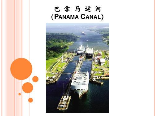
巴拿马运河(英语:Panama Canal;语:Canal de Panamá)位于中美洲的巴拿马,横穿巴拿马地峡,总长82公里,宽的地方达304米,最窄的地方也有152米。
该运河连接太平洋和大西洋,是重要的航运要道,被誉为世界七大工程奇迹之一和“世界桥梁”。
巴拿马运河是巴拿马共和国拥有和管理的水闸型运河,切过狭窄的巴拿马地峡,连接大西洋和太平洋。
其长度,从一侧的海岸线到另一侧海岸线约为65公里(40 哩),而由大西洋(更确切地讲是加勒比海)的深水处至太平洋的深水处约82公里(50哩)。
1911年7月24日(辛亥年六月廿九),马丘比丘重被发现。
1911年的7月24日马丘比丘重被发现。
马丘比丘(语、英语:Machu Picchu,奇楚亚语:Machu Piqchu,其意为“古老的山”),又译麻丘比丘,是一个著名的前时期时印加帝国的遗迹,西北方距库斯科130公里,整个遗址高耸在海拔2350—2430米的山脊上,俯瞰着乌鲁班巴河谷,也是世界新七大奇迹之一。
由于独特的位置、地址特点和发现时间较晚(1911年),马丘比丘成了印加帝国最为人所熟悉的标志。
在1983年,马丘比丘被教科文组织定为世界遗产,是世界上为数不多的文化与自然双重遗产之一。
但与此同时,马丘比丘也面临着遭旅游业破坏的担忧。
1911年的7月24日,学者海勒姆·宾厄姆三世让西方世界注意到了马丘比丘。
他被熟悉此地的本地人带到马丘比丘。
这位受争议的探险家-考古学家在这里完成了一份该地区的考古学报告。
宾厄姆想出了“失落的印加城市”这个吸引人的名字,并用作他第一本书的书名。
2002年,其他不为人知的二十世纪探险家留下的足迹被人发现,这些发现显示宾厄姆当初为了成为公认的马丘比丘发现者而故意掩盖了这些痕迹。
虽然发现马丘比丘的功劳落到了宾厄姆的头上,长期研究库斯科的Simone Waisbard仍然坚称马丘比丘的发现者另有其人,最先到访这里的是Enrique Palma,Gabino Sánchez和Agust ín Lizárraga,他们于1901年7月14日将名字刻在了一块岩石上。
巴拿马运河
巴拿马运河开闸过船,吸引大批游客观看, 巴拿马运河开闸过船,吸引大批游客观看,成为当 地旅游业亮点。 地旅游业亮点。
闸口为一艘游轮打开,内外水位放平, 闸口为一艘游轮打开,内外水位放平,可以通行
船舶过闸后,再重新关闸蓄水,等待下一次船过开闸。 船舶过闸后,再重新关闸蓄水,等待下一次船过开闸。
建于1913年的船闸,即将经历百年风霜。 建于1913年的船闸,即将经历百年风霜。 1913年的船闸
行驶于美国东西海岸之 间的船只, 间的船只,原先不得不绕道 南美洲的合恩角, 南美洲的合恩角,使用巴拿 马运河后可缩短航程约 15,000公里。 15,000公里。由北美洲的一 公里 侧海岸至另一侧的南美洲港 口也可节省航程多达6,500公 口也可节省航程多达6,500公 6,500 里。航行于欧洲与东亚或澳 大利亚之间的船只经由该运 河也可减少航程3,700公里。 河也可减少航程3,700公里。 3,700公里
中海船舶经过巴拿马运河
运河俯瞰
运河夜景
运河闸口夜景
2008年12月5日,俄罗斯海军“恰巴年科海军上将”号反潜驱逐舰通 过巴拿马运河。唯一一起类似事件发生在1944年,正值二战期间, 4艘俄罗斯潜艇穿越了巴拿马运河。
巴拿马运河对世界各地所有船只开放,运河永久中立。 巴拿马运河对世界各地所有船只开放,运河永久中立。
巴拿马运河的两端地势低,中间地势高,落差26米 巴拿马运河的两端地势低,中间地势高,落差26米,每次 26 船舶通过闸口需要的流失2600万加仑( 12万 2600万加仑 的水, 船舶通过闸口需要的流失2600万加仑(约12万M³)的水,每天一 共要通过35 40首船 大量宝贵的淡水每天白白流进了大海。 35到 首船。 共要通过35到40首船。大量宝贵的淡水每天白白流进了大海。 巴拿马政府也想过取用海水在运河中, 巴拿马政府也想过取用海水在运河中,又怕海水的咸度破 坏了当地热带丛林的生态变化。 坏了当地热带丛林的生态变化。幸好当地热带丛林的多雨气候 维持了运河的运行。 维持了运河的运行。
巴拿马运河简介中考地理知识点必备
巴拿马运河简介中考地理知识点必备巴拿马运河(西班牙语:Canal de Panamá)位于中美洲的巴拿马,横穿巴拿马地峡,连接太平洋和大西洋,全长82公里,大致呈西北—东南走向。
运河最宽处达304米,最窄处也有152米,是世界的航运要道。
“世界七大工程奇迹”之一、世界三大国际通航运河之一、被誉为“世界桥梁”、承担着全世界5%的贸易货运量等等。
巴拿马运河被誉为“世界桥梁”——它南起太平洋巴拿马湾的巴尔博亚港,北止加勒比海利蒙湾,长68公里,连同两端海湾中人工深水航道,全长81.8公里,共设三道船闸,全程约需9小时,它的开通使两大洋间的航程缩短5500海里。
连接南北美洲、沟通大西洋与太平洋的战略位置和交通枢纽的重要标志建筑物。
在遥远的殖民时代,巴拿马地峡是连接太平洋与西班牙宗主国的交通枢纽,每年一度的波托弗洛交易会吸引着欧洲各大商行的代理商,在这里,成吨的秘鲁白银与欧洲货物进行着有利可图的交易,巴拿马因商业和海运日益繁荣。
然而,这并没有改变它从属的地位。
1881年,法国人开始建造巴拿马运河,但很快由于工程技术问题和劳工的高死亡率而停工。
美国于1904年接手这一工程,并于1914年8月15日建成。
作为人类有史以来最大的工程项目之一,巴拿马运河极大地缩短了船只来往于大西洋和太平洋之间的时间,使船只能够避开遥远而危险的合恩角附近的麦哲伦海峡和德雷克海峡。
在运河的建造过程中,哥伦比亚、法国和美国先后控制了运河周边的区域。
美国之后一直控制着运河和其周边的巴拿马运河区,直到1977年签署《巴拿马运河条约》后,美国才着手将控制权移交给巴拿马。
美国和巴拿马共同管理运河一段时期后,最终在1999年将运河完全移交给巴拿马政府,并由其所属的巴拿马运河管理局管理至今。
英语口语:每日一图第164期 巴拿马大运河
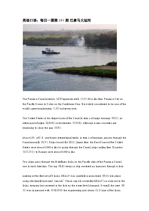
英语口语:每日一图第164期巴拿马大运河The Panama Canal extends (延伸)approximately (大约) 50 miles from Panama City on the Pacific Ocean to Colon on the Caribbean Sea. It is widely considered to be one of the world's great engineering (工程) achievements.The United States is the largest user of the Canal in terms of cargo tonnage (吨位), as either port of origin (起始地) or destination (目的地), although Asian countries are beginning to close the gap (差距).About 12% of U.S. sea-borne international trade, in terms of tonnage, passes through the Canal annually (每年). Ships bound for (驶往) Japan from the East Coast of the United States save about 3,000 miles by going through the Canal; ships sailing from Ecuador (厄瓜多尔) to Europe save about 5,000 miles.Two ships pass through the Miraflores locks on the Pacific side of the Panama Canal, one in each direction. The tug (绳索) keeps a ship centered as it passes through a lock.Arriving at the first set of 3 locks, HEALY was carefully maneuvered (移动) into place using electrically-powered "camels". These camels controlled HEALY's movement in the locks, keeping her centered in the lock as the water level changed. Overall, the crew (船员) was impressed with (印象深刻) the engineering and sheer (完全)size of the locks.Gatun Lake stores water to make the Panama Canal locks work. Water flows by gravity to raise the level in the lock chamber. Water is released to lower the level.原文来自必克英语/topic-10331.html。
- 1、下载文档前请自行甄别文档内容的完整性,平台不提供额外的编辑、内容补充、找答案等附加服务。
- 2、"仅部分预览"的文档,不可在线预览部分如存在完整性等问题,可反馈申请退款(可完整预览的文档不适用该条件!)。
- 3、如文档侵犯您的权益,请联系客服反馈,我们会尽快为您处理(人工客服工作时间:9:00-18:30)。
HistoryThe history of the Panama Canal goes back to 16th century. After realizing the riches of Peru, Ecuador, and Asia, and counting the time it took the gold to reach the ports of Spain, it was suggested c.1524 to Charles V, that by cutting out a piece of land somewhere in Panama, the trips would be made shorter and the risk of taking the treasures through the isthmus would justify such an enterprise. A survey of the isthmus was ordered and subsequently a working plan for a canal was drawn up in 1529. The wars in Europe and the thirsts for the control of kingdoms in the Mediterranean Sea simply put the project on permanent hold.In 1534 a Spanish official suggested a canal route close to that of the now present canal. Later, several other plans for a canal were suggested, but no action was taken. The Spanish government subsequently abandoned its interest in the canal.In the early 19th century the books of the German scientist Alexander von Humboldt revived interest in the project, and in 1819 the Spanish government formally authorized the construction of a canal and the creation of a company to build it. The discovery of gold in California in 1848 and the rush of would-be miners stimulated Americas interest in digging the canalVarious surveys were made between 1850 and 1875 showed that only two routes were practical, the one across Panama and another across Nicaragua. In 1876 an international company was organized; two years later it obtained a concession from the Colombian government to dig a canal across the isthmus. The international company failed, and in 1880 a French company was organized by Ferdinand Marie de Lesseps, the builder of the Suez Canal.In 1879, de Lesseps proposed a sea level canal through Panama. With the success he had with the construction of the Suez Canal in Egypt just ten years earlier, de Lesseps was confident he would complete the water circle around the world.Time and mileage would be dramatically reduced when travelling from the Atlantic to the Pacific ocean or vice versa. For example, it would save a total of 18,000 miles on a trip from New York to San Francisco.Although de Lesseps was not an engineer, he was appointed chairman for the construction of the Panama Canal. Upon taking charge, he organized an International Congress to discuss several schemes for constructing a ship canal. De Lesseps opted for a sea-level canal based on theconstruction of the Suez Canal. He believed that if a sea-level canal worked when constructing the Suez Canal, it must work for the Panama Canal.In 1899 the US Congress created an Isthmian Canal Commission to examine the possibilities of a Central American canal and to recommend a route. The commission first decided on a route through Nicaragua, but later reversed its decision. The Lesseps company offered its assets to the United States at a price of $40 million. The United States and the new state of Panama signed the Hay-Bunau-Varilla treaty, by which the United States guaranteed the independence of Panama and secured a perpetual lease on a 10-mile strip for the canal. Panama was to be compensated by an initial payment of $10 million and an annuity of $250,000, beginning in 1913. This strip is now known as the Canal Zone.The ConstructionThe length of the Panama Canal is approximately 51 miles. A trip along the canal from its Atlantic entrance would take you through a 7 mile dredged channel in Limón Bay. The canal then proceeds for a distance of 11.5 miles to the Gatun Locks. This series of three locks raise ships 26metres to Gatun Lake. It continues south through a channel in Gatun Lake for 32 miles to Gamboa, where the Culebra Cut begins. This channel through the cut is 8 miles long and 150 metres wide. At the end of this cut are the locks at Pedro Miguel. The Pedro Miguel locks lower ships 9.4 metres to a lake which then takes you to the Miraflores Locks which lower ships 16 metres to sea level at the canals Pacific terminus in the bay of Panama. A pictorial view of the canals route can be seen below.The Panama Canal was constructed in two stages. The first between 1881 and 1888, being the work carried out by the French company headed by de Lessop and secondly the work by the Americans which eventually completed the canals construction between 1904 and 1914.The contract for the canals construction was signed on March 12th, 1881, and it was agreed the work would be carried out for 512 million French francs, but the contract was conditional in the sense it was not to become binding until two years had elapsed.During 1882 the excavation of the Culebra Cut was started, but due to the lack of organization there were no tracks available to remove the spoilthat the excavators were producing. After the problems had been overcome, the highest peaks of the cut were attacked. As work proceeded, the worry of landslides and what slope should be adopted to avoid them became a major concern.In 1883 it was realised there was a tidal range of 20 feet at the Pacific, whereas, the Atlantic range was only about 1 foot. It was concluded that this difference in levels would be a danger to navigation. It was proposed that a tidal lock should be constructed at Panama to preserve the level from there to Colon. This plan would save about 10 million cubic metres of excavation.The French company started to run into financial difficulties during 1885 and even applied to the French government to issue lottery bonds, as this had been successful during the construction of the Suez canal when that project was at the point of failure through lack of money. Rumours of these difficulties caused increased interest within the American government.A report made by the Americans in 1886 noted that housing for the workforce was under construction and a great deal of plant was available. Unfortunately the plant required to construct the canal was is in shortsupply, there were too few dredgers, the French excavators were too light and were stopped by large boulders and too much work was being done by hand. The turnover of the labour force was immense, as the men wanted to return home to spend the savings they had accumulated and because of the inadequate medical care that was available.It was realised that the solution to all the problems encountered, was that the construction of a high-level lock canal would reduce an enormous volume of excavation and prevent the landslides.The abandonment of the scheme at this stage would cause financial ruin for all the investors and a severe blow to the French. It was suggested that the original plan should be modified and the lock system should be employed.Eventually, in 1899 the French attempt at constructing the Panama Canal was seen to be a failure. However, they had excavated a total of 59.75 million cubic metres which included 14.255 million cubic metres from the Culebra Cut. This lowered the peak by 102 metres. The value of work completed by the French was about $ 25 million. When the French left, they left behind a considerable amount of machinery housing and a hospital. The reasons behind the French failing to complete the projectwere due to disease carrying mosquitos and the inadequacy of their machinery.The construction of the canal was recommenced by the Americans in 1904. The first step on the agenda was to improve the standard of living and ensure ill health would be a thing of the past.The first American steam shovel started work on the Culebra cut on 11th November 1904. By December 1905 there were 2,600 men at work in the Culebra cut.Sidings and tracks for the spoil wagons had been laid, the dredging at both the Atlantic and Pacific portions of the canal were being carried out and a survey of the area for the largest dam along the canal had been started.It wasn't until June 1906 that the decision on type of canal was decided. It was to be a lock canal. This would enable the river Chagres to form a lake.Peak excavation within the Culebra cut exceeded 512,500 cubic metres of material in the first three months of 1907 and the total workforceexceeded 39,000. The rock was broken up by dynamite, of which up to 4,535,000 killogrammes were used every year.The plant used in the Culebra cut included in excess of 100 Bucyrus steam shovels each capable of excavating approximately 920 cubic metres in an eight-hour day, a picture of a typical steam shovel is shown below.More than 4,000 wagons were used for the removal of the excavated material. Each wagon was capable of carrying 15 cubic metres of material. These wagons were hauled by 160 locomotives and unloaded by 30 Lidgerwood unloaders.The full extent of the excavations carried out by both the French and Americans is shown in a longitudinal section from the Atlantic to Pacific oceans is shown below.Problems at the Culebra CutWhen the canal was first designed, the problem of landslides had been ignored. Slides of earth and more importantly rock, increased the amount of excavation within Culebra. The cross section of the canal was constantly being changed to accommodate for the landslides. The slides caused the upper edge of the cut to be taken back beyond their original lines. The original design for the banks comprised a series of narrow benches which acted as rock catchers, alternating with short steep slopes. It was first decided by the International Board of Consulting Engineers that the rock would be stable at a slope of 1 in 1.5, it was also stated the rock had the strength to stand at a height of 73.5 metres at 1 in 1.5. In fact the rock began to collapse from that slope at a height of only 19.5 metres.Numerous test borings had been carried out and samples of the rock were taken, therefore, the quality of the rock was known. The reason for the misjudgement of the strength was due to the underlying strata which contained bands of clay and iron pyrites. The iron pyrites seemed to cause the problems, as it is liable to oxidize when exposed to the air and moisture, with the result that the rock would disintegrate. Therefore, when the overlying material had been removed, rainwater precipitatedthrough to the lower strata which included the pyrites, whereby rapid deterioration occurred.The first major slide occurred in 1907 at Cucaracha. The initial crack was first noted on October 4th, 1907, then without warning approximately 382,000 cubic metres of clay, moved more than 4 metres in 24 hours. This slide caused many people to suggest the construction of the Panama Canal would be impossible. The clay was too soft to be excavated by the steam shovels and was eventually removed by sluicing with water from a high level.The Cucuracha slide was to become a problem again in 1913, when it crossed the cut until it reached the opposite bank. The steam shovels excavated the slide as it was moving and eventually won the battle. A picture of the Cucaracha slide is shown in figure 4 below.Further movements were experienced at the base of the cut, including the sudden upheaval of the ground at the middle and a sinking of the ground in other areas. These movements were caused by the pressure of the rock, which seemed to flow as soil and not having the typical behaviour of rock.This problem was overcome by removing material from the upper levels of the cut thus, reducing the pressure.As a direct result of all the slides and upheavals encountered, excavation increased by 15.3 million cubic metres. This was about 25% of the total estimated amount of earth moved.The slides which were encountered didn't cause any delay in the progress of the canal, as this was determined by the speed at which the locks were constructed.Many projects to enhance and widen the channels have been carried out since the opening of the canal. The main area to receive these works has been the Culebra Cut as numerous landslides have occurred and the need for two ships to pass.The LocksAlong the route of the canal there is a series of 3 sets of locks, the Gatun, Pedro Miguel and the Miraflores locks.At Gatun there are 2 parallel sets of locks each consisting of 3 flights. This set of locks lift ships a total of 26 metres. The locks are constructed from concrete from which the aggregate originated from the excavated rock at Culebra. The excavated rock was crushed and then used as aggregate. In excess of 1.53 million cubic metres of concrete was used in the construction of the Gatun locks alone.Initially the locks at Gatun had been designed as 28.5 metres wide. In 1908 the United States Navy requested that the locks should be increased to have a width of at least 36 metres. This would allow for the passage of US naval ships. Eventually a compromise was made and the locks were to be constructed to a width of 33 metres. Each lock is 300 metres long with the walls ranging in thickness from 15 metres at the base to 3 metres at the top. The central wall between the parallel locks at Gatun has a thickness of 18 metres and stands in excess of 24 metres in height. The lock gates are made from steel and measures an average of 2 metres thick, 19.5 metres in length and stand 20 metres in height.When Colonel Geothals the American designer of the Panama Canal visited the Kiel Canal in 1912 he was told the canal should have been built 36 metres in width, but by then it was too late. The locks can be seenduring construction below. A general picture of the Gatun locks can be seen below.The smallest set of locks along the Panama Canal are at Pedro Miguel and have one flight which raise or lower ships 10 metres. The Miraflores locks have two flights with a combined lift or decent of 16.5 metres.Both the single flight of locks at Pedro Miguel and the twin flights at Miraflores are constructed and operated in a similar method as the Gatun locks, but with differing dimensions.The DamsMany engineering aspects of the Panama Canal point out the concern for the protection of the environment and natural resources.As the excavations were being carried out, an enormous amount of excess soil was produced. The French initially hauled the soil to an adjacentvalley where the soil was dumped and allowed to build up. This itself caused many problems during the rainy season and was the cause behind many of the landslides.When the Americans started work on the canal, the engineers decided to reuse this soil for the building of the Gatun dam. This dam held back the water from the Chagres river and thus creating the Gatun lake. As time passed, the soil would continue to settle thus, increasing the strength of the dam.The dam itself is 1.5 miles in length and is nearly 0.5 mile wide at its base. The construction of the dam involved constructing 2 walls along its length using the excavated rock from the Culebra cut. The space between these 2 walls was then built up with impervious clay. This clay gradually dried and hardened into a solid mass almost equal to concrete in its water-resistant properties. This dam contains 16.9 million cubic metres of rock and clay, equivalent too about one tenth of the entire excavation of the canal.The dams at Pedro Miguel and Miraflores are small in comparison to Gatun. Their foundations are on solid rock and are subjected to a head ofwater of 12 metres, whereas the Gatun dam is subjected to a 24 metre head.The dam at Pedro Miguel is an earth dam approximately 300 metres in length with a concrete core wall.At Miraflores there are two dams forming a small lake with an area of about 2 square miles. One of the dams is constructed of earth and is 210 metres in length. The second of the dams at Miraflores is 150 metres in length and is made from concrete.Back to Contents--------------------------------------------------------------------------------The FutureThe ships for which the canal was designed are now long gone. Modern shipping has increased the size of ships. The increase in the tonnage in which can be carried has thus caused problems for the canal. The canal can only accommodate ships carrying up to 65,000 tons of cargo, but recently ships which are able to carry 300,000 tons have been introduced.The problem of the ever-increasing size in ships has caused discussion into the construction of a new canal joining the Pacific and Atlantic oceans. There have been discussions on three alternative routes for a new canal, through; Columbia, Mexico and Nicaragua. The Columbian and Mexican routes would allow for the construction of a sea level canal, whereas the Nicaraguan route would require a lock system.If a replacement canal were to be constructed, the economic effect on the Republic of Panama would be a great concern as the present canal employs 14,000 people, of which 4,000 are Panamanians. It has been suggested that, if a new canal were to be built, the existing canal could be converted to a hydroelectric power station at a relatively small cost. As Panama has no iron-ore deposits and lacks oil, natural gas resources or skilled labour, there is no real need for a new source of cheap power.The capacity of the existing canal could be increased by converting it to a sea level passage. This would be carried out by the dredging of more than 765 million cubic metres of earth and rock which could be carried out without interfering with existing canal traffic. Water retaining structures would be constructed to maintain the canal levels during excavation. When excavation had been completed, the water retaining structurewould be demolished by blasting them into deep pits. The lowering of the canals level would take place over a seven day period and would be the only time traffic would be disrupted.It was suggested during the 1960's that the canal could be increased in size by the use of nuclear explosives and would cost less than one third, and take about half the time than using conventional excavation methods. It is now obvious that this would cause a great deal of concern for all anti-nuclear groups.The Panama Canals administration will be under the control of Panama in 1999.ConclusionWhat makes the Panama Canal remarkable is its self sufficiency. The dam at Gatun, is able to generate the electricity to run all the motors which operate the canal as well as the locomotives in charge of towing the ships through the canal. No force is required to adjust the water level between the locks except gravity. As the lock operates, the water simply flows into the locks from the lakes or flows out to the sea level channels. The canal also relies on the overabundant rainfall of the area tocompensate for the loss of the 52 million gallons of fresh water consumed during each crossing.Despite the limit in ship size, the canal is still one of the most highly travelled waterways in the world, handling over 12,000 ships per year. The 51-mile crossing takes about nine hours to complete, an immense time saving when compared with rounding the tip of South America.Until the early 1970's the Panama Canal Company made considerable profits. After a period of nearly 60 years the loss in profit required the increase of tolls 3 times in 4 years. Much of the equipment, some of which dates back too 1914, now requires expensive modifications, simply to continue moving its present rate of traffic.The original plan for the Panama Canal was evolved from many years of engineering study, but it was unfortunate that it had not been based on marine operating experience.参考资料:/~sl5763/panama.htm#Conclusion Bibliography1 Barrett, J. The Panama Canal, what it is, what it means. 1913.2 Hammond & Lewin. The Panama Canal. 1966.3 LaFeber, W. The Panama Canal, The crisis in historical perspective. 1978.4 Microsoft Encarta 96 Encyclopaedia.5 Encyclopedia Britannica.Back to ContentsReturn to homeOther Panama Canal Sites。