龙门山断裂带
川西龙门山断裂带活动性特征
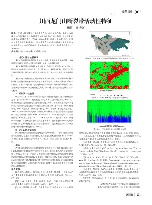
建筑设计191产 城川西龙门山断裂带活动性特征邹媛1 王祥松2摘要:龙门山断裂带位于青藏高原东缘,四川盆地西界,是构造活动较强的巴颜喀拉地块和较稳定的川滇块体之间的界线,同时也是我国南北地震带的中部,呈NE-SW向展布,构造位置非常重要。
龙门山断裂带具有长期活动性,张培震等在2008年通过GPS发现龙门山断裂带在长达10年的时间内,它的构造变形的速度都非常的小(小于2mm/a )。
关键词:龙门山断裂带;活动性;特征1 龙门山区域地质概况龙门山是青藏高原和四川盆地的分界线,也是扬子地块和松潘—甘孜地块的分界线,还是中国中西部地质、地貌、气候的陡变带。
龙门山断裂带主要包括 3 条大断裂,自西向东分别是:龙门山后山大断裂:汶川-茂县-平武-青川; 龙门山主中央大断裂:映秀-北川-关庄,属于逆走滑断裂;龙门山主山前边界大断裂:都江堰-汉旺-安县,属于逆冲断层。
龙门山地区的构造位置属于扬子板块的西北部,其在羌塘板块和扬子板块相互的挤压的过程中形成的逆冲推覆构造带,是中国大陆造山带的一个典型。
在龙门山地区内,它的地势西北部分较高,而东南部分较低。
在西北部分是山石青峰,山峦巍峨起伏的龙门山山脉,主要是要由变质岩,岩浆岩构成。
2 断裂活动性差异研究表明,龙门山断裂带晚第四纪活动性分段特征明显,以往研究认为北(平武—青川断裂)晚更新世以来已不再活动(李传友等,2004;),最新的研究认为全新世是活动的(孙浩越,2015)。
中段在晚第四纪以来有活动,而南段因为分支较多等因素活动性较中段弱(李传友等,2004;杨晓平等,1999;邓起东等,1994;赵小麟等,1994;李勇等,2006;周荣军等,2006;)。
由断裂活动引起的水系扭曲、断裂槽谷、阶地位错等现象充分验证了以上结论(唐荣昌等,1993; Densmore et al.,2007;陈国光等,2007;贾营营等,2010;陈立春等,2013)。
2008 年汶川 Ms8.0 地震中沿北川-映秀断裂和灌县-江油断裂两条断裂发生地表破裂,表明了这两条断裂的最新活动性。
龙门山汶川-茂县断裂带的岩石磁学特征及其地震作用的指示意义
2023/039(12):3817 3832ActaPetrologicaSinica 岩石学报doi:10.18654/1000 0569/2023.12.17张蕾,李海兵,孙知明等.2023.龙门山汶川 茂县断裂带的岩石磁学特征及其地震作用的指示意义.岩石学报,39(12):3817-3832,doi:10.18654/1000-0569/2023.12.17龙门山汶川 茂县断裂带的岩石磁学特征及其地震作用的指示意义张蕾1,2,3 李海兵1,2,3 孙知明4 葛成隆1 叶小舟4 曹勇4 郑勇1,2,3ZHANGLei1,2,3,LIHaiBing1,2,3 ,SUNZhiMing4,GEChengLong1,YEXiaoZhou4,CAOYong4andZHENGYong1,2,31 中国地质科学院地质研究所,自然资源部大陆动力学重点实验室,北京 1000372 南方海洋科学与工程广东省实验室(广州),广州 5114583 江苏东海大陆深孔地壳活动国家野外科学观测研究站,连云港 2223004 中国地质科学院地质力学研究所,自然资源部古地磁与古构造重建重点实验室,北京 1000811 MNRKeyLaboratoryofContinentalDynamics,InstituteofGeology,ChineseAcademyofGeologicalSciences,Beijing100037,China2 SouthernMarineScienceandEngineeringGuangdongLaboratory(Guangzhou),Guangzhou511458,China3 JiangsuDonghaiContinentalDeepBoreholeCrustalActivityNationalObservationandResearchStation,Lianyungang222300,China4 MNRKeyLaboratoryofPaleomagnetismandTectonicReconstruction,InstituteofGeomechanics,ChineseAcademyofGeologicalSciences,Beijing100081,China2023 08 01收稿,2023 11 12改回ZhangL,LiHB,SunZM,GeCL,YeXZ,CaoYandZhengY 2023 RockmagneticcharacteristicsoftheWenchuan MaoxianfaultzoneoftheLongmenShanfaultanditsearthquakefaultingcharacteristics.ActaPetrologicaSinica,39(12):3817-3832,doi:10.18654/1000 0569/2023.12.17Abstract TheWenchuan MaoxianFaultZone(WMFZ),theboundaryfaultbetweentheSongpan GanzifoldzoneandtheLongmenShanFaultZone(LSFZ),didnotruptureduringthe2008MW7 9Wenchuanearthquake Furthermore,therewerenorecordsfortheexistenceoftheformerlargemagnitudeearthquakeshadbeenfoundinthisfaultzone TheseproblemshinderprogressinunderstandingboththeearthquakemechanismoftheWenchuanearthquakeandtheformationandevolutionoftheLSFZ Therefore,thefaultingenvironmentoftheWMFZiscrucialinunderstandingtheearthquakemechanismoftheLSFZ Rockmagneticstudyoffaultrockscaneffectivelyrevealthephysicalandchemicalenvironmentofthefaults Here,wecarriedoutrockmagneticanalysescombinedwithmicrostructuralandgeochemicalanalysesoffaultrocksandwallrocksfromthenorthernWMFZ Thehighestmagneticsusceptibilityvaluesoffaultgougeandbrecciaareabout30and15timesofthatofthewallrocks,respectively Rockmagneticanalysisresultsindicatethatthemagneticmineralsinthefaultgougearepyrrhotite,goethitetogetherwithsomemagnetite,whilethoseinthefaultbrecciaarepyrrhotiteandgoethite Thehightemperatureoffrictionalheatingandfluidsinducedthermaldecompositionofparamagneticminerals,formingpyrrhotiteandmagnetitetoalesserextent,andthuscontributingtoahighermagneticsusceptibilityvaluesofthefaultgouge Highermagneticsusceptibilityvaluesoffaultbrecciaresultsfromthenewly formedpyrrhotitebyreductivelow temperaturehydrothermalfluidswithlargeamountsofsulfur Goethiterevealsthepresenceofreductivelow temperaturehydrothermalfluidsafteranearthquake Thehighmagneticsusceptibilityvaluesoffaultrocksandthenewly formedmagnetiteindicatethatlargeearthquakeswithfrictionalheating(>500℃)didhaveoccurredalongtheWMFZinthepasttime,andthisfaultkeptinareductiveenvironmentwithlow temperaturehydrothermalfluidsthatcontainhighsulfurduringandaftertheearthquakesKeywords Faultgouge;Rockmagnetism;Faultingenlivenment;Largeearthquake;Wenchuan Maoxianfaultzone本文受国家自然科学基金项目(41830217、42172262、42072240、41972229)、中国地质调查项目(DD20221630)和南方海洋科学与工程广东省实验室(广州)人才团队引进重大专项(GML2019ZD0201)联合资助.第一作者简介:张蕾,女,1988年生,博士,副研究员,主要从事岩石磁学及断裂作用研究,E mail:zhanglei881102@126.com通讯作者:李海兵,男,1966年生,博士,研究员,主要从事构造地质学及活动构造研究,E mail:lihaibing06@163.com摘 要 汶川 茂县断裂带是龙门山后山断裂,是松潘 甘孜褶皱带与龙门山断裂带之间的边界断层,然而,在2008年MW7 9级汶川大地震中并没有发生破裂。
多灾变区域山地旅游开发研究——以龙门山断裂带为例
网络广告是一 门包含艺术和技术的综合性 工程 。在 日新月 异 的社 会 变 革 中 , 计 师 唯 有 不 断 学 习 , 设 紧跟 时代 潮 流 的 变 化 , 熟练掌握 网络广告的设计技术 ,才能更好地在 网络广告有 限的
可 视 空 间 中开 创无 限可 能 的虚 拟 空 间 。
创新的广告形式本身就是好的广告基本标 准 ,因而要将传 统广告创新的手段运用到 网络广告上。这样不仅能减少 网民对 网络广告的排斥感 , 而且还能使广告 的效果大大提高 , 逐渐增 强 网民对于网络广告 的信任度 。 创新要适合 网络广告特点 , 针对 广 告 目标 , 针对受众心理 , 迎合网 民的接受心理与习惯。如新颖 的 交互式广告 、 叫广告 、 中广告 、 呼 文 视频广告等等 。
相媲美。
坡、 崩塌 、 泥石 流等次生灾害 ,直接受威胁 的人数达 10多万 , “ 0 是中国有史以来 一次性灾变事件 引发的最严重 的地质灾 害”】 口, 使 四川旅游业再次陷入困境。从 地震及其 引起 的次生灾害带来 的惨痛损失来看 ,限一退二进三”必将成为龙 门山地带生产力 “ 布局和产业结构调整 的惟一选择。而旅游业作 为第三产业 的主 导产业之一 ,承担着调整生产力 要素布局和 引导产业结构调整 的重要任务圆 。而山地旅游作为一种新型的现代旅游形式 , 其产 品涵盖观光 、 户外 运动 、 普教育 、 科 节事等多 个方 面 , 有样式 具
展。
关键词 : 多灾变 区域 ; 山地旅游; 门山断裂带; 龙 限制 因素
引 言
51 . 2汶川 地 震 , 四川 旅 游 业 沉 重 的打 击 。 震 后 , 给 因地 震 灾 害 改 变 了灾 区地 质 地 貌 状 况 , 遭 遇 多 次 强 降雨 天气 , 发 了滑 又 引
龙门山断裂带地震研究
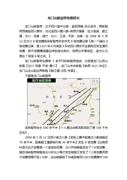
龙门山断裂带地震研究龙门山断裂带,位于四川省中北部,呈现西南-东北走向,其断裂带西南起四川雅安,东北至四川青川县-陕西宁强县,经大邑县,都江堰,汶川,茂县,绵竹,北川,江油,平武,剑阁;在2008年5月12日汶川8级地震前该断裂带历史并无8级地震记录【有一个疑似8级地震记录,是1327年8月底至9月初四川雅安天全县附近发生强烈地震,那次地震震感最远传到湖北荆州,陕西汉中等地区,官方认为是在7级至8级之间。
】龙门山断裂带主要有3条平行的断裂带组成,分别是龙门山后山断裂【汶川-茂县-平武-青川】,龙门山中央断裂【映秀-北川-关庄】,龙门山主山前边界断裂【都江堰-汉旺-安县】。
下图是龙门山断裂带该断裂带全长500多千米【个人通过谷歌测距测到了是538千米左右】。
2008年5月12日四川省汶川县【实际上震中距离汶川县城接近70多千米,距离都江堰县城只有30多千米】发生8级地震【也有资料显示此次地震是一个连发的双震,汶川开始破裂发生了7.8级地震,随后当断裂带破裂到北川时北川再次发生破裂又发生了7.2级地震而两次地震相隔不到1分钟,这也就解释了为啥距离四川汶川地震震中100多千米外的北川比距离震中30多千米外的都江堰灾情更严重了。
】;地震属于逆冲-走滑行地震,地震属于巴颜喀拉山地块和扬子淮板块间的碰撞导致的。
此次地震将龙门山断裂带中段-北川这接近300多千米的断裂区域几百年甚至几千年累计的地壳挤压能量几乎全部释放了,不过要值得注意的是龙门山断裂带长度是达到500多千米呢,释放了300多千米应该还有接近200千米【地震局在汶川地震后勘探显示释放了320千米的断裂带的应力】;而至200多千米未释放能量的区域自2008年后也出现了活跃并且在2013年再次释放;2013年4月20日四川省雅安市芦山县龙门乡附近发生7级地震【USGS测定为6.6级】;此次地震位于龙门山断裂带的南段,地震释放了35千米至40千米断裂带的几百年累积的能量。
龙门山断裂带印支期左旋走滑运动及其大地构造成因
龙门山断裂带印支期左旋走滑运动及其大地构造成因王二七1,孟庆任1陈智樑2,陈良忠3(1.中国科学院地质与地球物理研究所岩石圈构造演化开放实验室,北京100029;2.国土资源部成都地质矿产研究所,四川成都610082;3.云南省地质科学研究所,云南昆明650011)摘 要:位于青藏高原东缘的龙门山构造呈北东 南西向将松潘 甘孜褶皱带和华南地块分割开。
前者主要是由一套巨厚的三叠纪复理石沉积组成,分布在古特提斯海的东缘。
后者由前寒武纪基底和上覆的古生代和中生代沉积盖层组成。
位于汶川 茂汶断裂以东的前龙门山存在一系列倾向北西的逆掩断层,它们将许多由元古宙和古生代岩层组成的断片向南东置于四川盆地的中生代红层之上,构成典型的薄皮构造。
许多研究由此断定松潘 甘孜褶皱带和四川盆地之间在中生代发生过大规模的北西 南东向挤压。
然而,汶川 茂汶断裂西侧的松潘 甘孜褶皱带内部的挤压构造线大多是垂直于而不是平形于龙门山断裂带,这表明当时的挤压应力不是北西 南东向而是北东 南西向。
近年来在龙门山构造带内发现,在三叠纪时龙门山断裂带在发生推覆的同时还经历过大规模的北东 南西向的左旋走滑运动,协调走滑运动的主要构造为汶川 茂汶断裂。
走滑运动的成因与松潘 甘孜褶皱带北东 南西向缩短有关。
汶川 茂汶断裂的左旋走滑在龙门山的北东端被古特提斯海沿勉略俯冲带的消减和发生在大巴山的古生代/中生代岩层的褶皱和冲断作用所吸收,在龙门山的南西端被古特提斯海沿甘孜 理塘俯冲带的消减和松潘 甘孜三叠纪复理石的褶皱和冲断作用所吸收。
因此,汶川 茂汶断裂实际上为古特提斯海和华南地块之间的一个转换断层。
松潘 甘孜三叠纪复理石带的北东 南西向缩短很可能与其向西的逃逸运动有关。
这些复理石沉积原先大部分可能堆积在秦岭一带,在印支期华南地块和华北地块发生陆内汇聚的过程中被挤出。
除此之外,位于龙门山北东端的碧口断块可能也是从秦岭中挤出来的。
关键词:龙门山;松潘 甘孜三叠纪复理石带;印支期;转换断层;地壳逃逸中图分类号:P54 文献标识码:A 文章编号:10052321(2001)02037510收稿日期:20001120;修订日期:20010308基金项目:国家重大基础研究发展规划青藏高原研究资助项目(1998040800)作者简介:王二七(1951 ),男,研究员,博士生导师,美国麻省理工学院客座研究员,构造地质学专业。
龙门山断裂映秀-北川断裂

映秀-北川断裂2008年5月12日14时28分,在龙门山发生了8. 0级特大地震。
此次地震不仅在震中区及其附近地区造成灾难性的破坏,而且在四川省和邻近省市大范围造成破坏,其影响更是波及到全国绝大部分地区乃至境外,是新中国建立以来我国大陆发生的破坏性最为严重的地震之一。
汶川大地震发震断裂为龙门山断裂带的中央主断裂-映秀-北川断裂。
1映秀-北川断裂概况1.1地质背景映秀-北川断裂所在的龙门山是青藏高原东缘边界山脉,北起广元,南至天全,长约500 km,宽约30 km,呈北东-南西向展布,北东与大巴山相交,南西被鲜水河断裂相截。
龙门山式构造由一系列大致平行的叠瓦状冲断带构成,具典型的逆冲推覆构造特征,具有前展式发育模式,自西向东发育汉川-茂汉断裂、映秀-北川断裂和彭县一灌县断裂。
由于该地区地质过程仍处于活动状态,变形显著,露头极好,地貌和水系是青藏高原隆升过程的地质纪录,因此龙门山不仅是研究青藏高原与周边盆地动力学(盆原动力学)的典型地区,而且是验证青藏高原是以地壳加厚还是左行挤出来吸收印亚大陆碰撞后印度大陆向北挤入作用的关键部位,同时也是研究青藏高原东缘活动断层和潜在的地震灾害的关键地区。
2映秀-北川断裂特点及影响2.1映秀-北川断裂的断层类型、地表破裂、变形特征及活动方式龙门山映秀-北川断裂属于逆冲一走滑型地震。
结果表明映秀-北川断裂的地表破裂带从映秀向北东延伸达180- 190 km,走向介于NE30°-50°之间,倾向北西,地表平均垂向断距为2.9 m,平均水平断距为3.1 m;地表最大错动量的地点位于北川县擂鼓镇,垂直断错为6.2士0.1 m,水平断错为6.8士0.2 m,逆冲分量与右行走滑分量的比值为3:1-1:1,表明该断裂以逆冲-右行走滑为特点,逆冲运动分量略大于或等于右行走滑运动分量。
根据近南北向的分段断裂可将映秀-北川断层的地表破裂带划分为两个高值区和两个低值区,其中两个高值区分别位于南段的映秀-虹口一带和中北段的擂鼓-北川县城-邓家坝一带。
龙门山断裂带地壳形变及应力特征研究
龙门山断裂带地壳形变及应力特征研究地震灾害以其突发性和不可准确预测性给人类生活带来了巨大的影响,2008年的汶川地震对中国人民造成巨大生命和财产损失。
20世纪地震学的最大进展之一是发现地震发生在断层上,随着空间技术的发展,GPS技术能够精确的获取地壳的形变信息,结合地质和地球物理资料,探求强震的孕育、发生以及发展规律,从而最大限度的降低地震的破坏程度。
本文以龙门山断裂带为研究区域,采用汶川地震同震GPS观测数据对该区域的速度场分区进行模拟。
运用平均矩张量技术对龙门山断裂地壳应力应变特征进行分段分析。
结合所构建的断层滑动分布模型,采用coulomb3.3软件<sup>[1,2]</sup>分析汶川地震所触发的库仑应力及对周边断层活动的影响。
论文的主要工作与成果如下:(1)采用多面函数模型,幂函数模型,最小二乘配置模型对所研究区域的速度场分别进行分区拟合,并对上述三种模型的拟合结果进行比较分析,其结论为多面函数模型的拟合效果最佳。
(2)运用Tam 技术<sup>[3]</sup>(平均矩张量技术)结合汶川地震余震震源机制解对研究区域的应力场特征进行分段研究,并与采用多面函数计算的应力场结果进行分析比较,得出利用平均矩张量技术所获得的龙门山断裂应力场分布特征具有一定的可靠性。
其应力场结果表明,汶川地震是一次以逆冲为主,兼少量右旋走滑分量的地震,其主压力P轴方位为NWW,与龙门山构造带应力场方位一致。
(3)通过RPS算法<sup>[4]</sup>(基于粒子群算法的全局最优化)反演龙门山断层滑动速率,利用该滑动速率模型和USGS的滑动分布模型<sup>[5]</sup>在coulomb3.3软件的基础上分别计算上述两个不同断层模型在指定接收断层和断层最优破裂面上所触发的库仑应力,通过对计算结果的比较分析,可得利用该滑动速率模型计算汶川地震所触发的库仑应力具有一定的可行性。
龙门山断裂带

龙门山断裂带龙门山断裂带与强震稽少丞2008年5月12日8.0级大地震发生在龙门山断裂带的中北段、今天雅安市芦山县发生的7.0级强震发生在龙门山断裂带的南段。
下面,我就科普一下龙门山断裂带。
在中国地图上有一条由著名地理学家胡焕庸(1901~1998)先生提出的“胡焕庸线”。
这条直线,北起黑龙江爱珲县、西南达云南腾冲,它把中国大陆分成西北和东南两部分,线的东南侧,土地只占整个国土面积的36%,人口却是全国的96%。
线的西北侧,情况恰恰相反。
在四川省的地图中,也有这样一条人口分布疏密的对比线,它就是龙门山脉。
龙门山以东是称之为“天府”的成都平原,“田肥美,民殷富……沃野千里,蓄积饶多,此谓天府。
”龙门山以西是中、高山、极高山和高原的世界,遍布湍急的河流、深切河谷,自然环境注定这里不能像川东一样养活众多的人口,而只能是游牧民的天下。
龙门山是青藏高原东缘边界山脉,横亘于青藏高原和四川盆地之间。
龙门山脉北东-南西向长约500 千米,北西-南东向宽约40~50 千米,从东到西分别是山前冲积平原(海拔约500 米)、高山地貌(海拔2000~5000 米)和高原地貌(海拔4000~5000 米),为当今世界上坡度最陡的高原边界。
龙门山地区的地形坡度比喜马拉雅山南坡的还大,这样的地貌特征本身就说明垂直龙门山方向上水平构造应力分量很大。
前人的野外地质考察和古地磁资料都证明龙门山脉晚新生代以来经受了强烈的右旋斜冲。
但是,横跨龙门山布设的GPS区域观测网在5.12之前的近十年的测量结果却显示基本上没有位移,有些人据此推断龙门山断裂带不是活动地震构造,把该地区从全国强震重点防范区的名单上剔除。
在5.12地震发生在前,当地政府和民众都认为龙门山地区不会有大地震发生,因此也就没有采取任何应对地震灾害的策略与措施,更没有为应对可能的地震灾害而储备救援物资。
事实上,在GPS观测的时间段内,龙门山断裂带处于闭锁状态,并不证明龙门山断裂带是不活动的构造。
- 1、下载文档前请自行甄别文档内容的完整性,平台不提供额外的编辑、内容补充、找答案等附加服务。
- 2、"仅部分预览"的文档,不可在线预览部分如存在完整性等问题,可反馈申请退款(可完整预览的文档不适用该条件!)。
- 3、如文档侵犯您的权益,请联系客服反馈,我们会尽快为您处理(人工客服工作时间:9:00-18:30)。
Crustal structure across Longmenshan fault belt from passive source seismic profilingZhongjie Zhang,1Yanghua Wang,2Yun Chen,1Gregory A.Houseman,3Xiaobo Tian,1 Erchie Wang,1and Jiwen Teng1Received13June2009;revised17July2009;accepted31July2009;published5September2009.[1]We analyse receiver functions from29broad-band seismographs along a380-km profile across the Longmenshan(LMS)fault belt to determine crustal structure beneath the east Tibetan margin and Sichuan basin.The Moho deepens from about50km under Songpan–Ganzi in east Tibet to about60km beneath the LMS and then shallows to about35km under the western Sichuan basin.The average crustal Vp/Vs ratios vary in the range1.75–1.88under Songpan–Ganzi in east Tibet, 1.8–2.0under the LMS,and decrease systematically across the NW part of the Sichuan basin to less than1.70.A negative phase arrival above the Moho under Songpan–Ganzi and Sichuan basin is interpreted as a PS conversion from the top of a low-velocity layer in the lower crust.The very high crustal Vp/Vs ratio and negative polarity PS conversion at the top of lower crust in east Tibet are inferred to be seismic signatures of a low-viscosity channel in the eastern margin of the Tibetan plateau.The lateral variation of Moho topography,crustal Vp/Vs ratio and negative polarity PS conversion at the top of the lower crust along the profile seem consistent with a model of lower crust flow or tectonic escape.Citation:Zhang,Z.,Y.Wang,Y.Chen, G.A.Houseman,X.Tian,E.Wang,and J.Teng(2009),Crustal structure across Longmenshan fault belt from passive source seismic profiling,Geophys.Res.Lett.,36,L17310,doi:10.1029/ 2009GL039580.1.Introduction[2]The continental collision between India and Eurasia in the Cenozoic has resulted in large crustal shortening across Asia[Molnar and Tapponnier,1975;Molnar and Chen,1978;Houseman and England,1993;Kind et al., 2002;Royden et al.,2008;Li et al.,2008].GPS measure-ments confirm that crustal material is moving eastward in the east Tibetan Plateau[Zhang et al.,2004]and is obstructed by the rigid Sichuan basin of the Yangtze block[Copley and McKenzie,2007].The abrupt(4-km)topographic relief across the Longmen-shan(LMS)belt between Eastern Tibet and the Sichuan basin has been interpreted as indicating: (1)The middle/lower crust of Tibet flows and thrusts to the surface as a channel to form the LMS fault system[Royden, 1996;Royden et al.,2008;Clark and Royden,2000;Klemperer,2006];(2)Lithospheric-scale escape[Wang et al.,2008]coupled with subduction of Sichuan basin mantle and underthrusting of its crust beneath Eastern Tibet[Xu et al.,1992;Tapponnier et al.,2001];or(3)The rigid crust of the Sichuan basin is wedged into the lower crust of the Songpan–Ganzi block[Cui et al.,1996].In order to evaluate the above-mentioned models and deepen our understanding of the interaction between Tibetan plateau and basin,we recorded teleseismic events on a profile across the LMS fault. The Mw8.0Wenchuan earthquake of12May2008happened along the LMS fault belt[Burchfiel et al.,2008]and further motivates our study of crust and upper mantle structure in the area.2.Seismic Acquisition and Receiver Function Image[3]Our passive seismic experiment was carried out alonga profile between Aba in east Tibet and Longquan(LQ)Mts. in the western Sichuan basin(Figure1)between August2006 and July2007.In this experiment,29seismographs(nine Reftek-130and20Reftek-72A data loggers and Guralp CMG3-ESP sensors of50Hz–30s)were deployed.Stations S01–S07are located in the western Sichuan basin,S08–S12 cross the LMS thrust faults zone with a station interval of 10km,and S13–S29are located on the Songpan–Ganzi block in east Tibet(station coordinates are provided in Table S1of the auxiliary material).4During the one year observation,264earthquakes with magnitude greater than Ms5.0in the distance range between30and90degrees(see Figure S1)were recorded.[4]We estimated receiver functions by a time-domain iterative deconvolution of vertical and radial seismograms [Ligorria and Ammon,1999].We have visually selected records with high signal-to-noise(S/N)ratio for each station, ensuring that the PS conversions from the Moho and its two later multiple phases are present.In total,we have obtained 1823receiver functions for all29stations along the profile. We present radial-and transverse-component receiver func-tions from Stations4and21located in Sichuan basin and Songpan-Ganzi,respectively(Figures2a and2b).All the radial-component receiver functions are included in Figure S2.The P and PS phases from the Moho can be seen clearly from those receiver-functions along the profile.The delay time between P and PS converted phases under the Sichuan basin is about5.5s and under the Songpan–Ganzi block is about7s.The change in delay times from5.5to7s, and the complicated conversion pattern under stations8–12 4Auxiliary materials are available in the HTML.doi:10.1029/ 2009GL039580.GEOPHYSICAL RESEARCH LETTERS,VOL.36,L17310,doi:10.1029/2009GL039580,2009 ClickHereforFullArticle1State Key Laboratory of Lithospheric Evolution,Institute of Geologyand Geophysics,Chinese Academy of Sciences,Beijing,China.2Department of Earth Science and Engineering,Imperial CollegeLondon,London,UK.3School of Earth and Environment,University of Leeds,Leeds,UK.Copyright2009by the American Geophysical Union.0094-8276/09/2009GL039580$05.00suggest an abrupt variation in crustal structure under the LMS fault belt,comparable to variation observed across major crustal sutures further to the west on the Plateau [Vergne et al.,2002]and in northern Tibet [Zhu and Helmberger ,1998].3.Migrated Receiver Function Image Along the Profile[5]In order to construct a depth-domain crustal conver-sion image,a migration scheme is used to focus the converted signal from the time series of each receiver function to its relevant conversion point.Figure 3a presents the migrated receiver-function section to the depth of 150km along the profile,using the imaging method of Yuan et al.[1997]and the IASP91model [Kennett and Engdahl ,1991].On the image,there are two remarkable features:strong variations in Moho depth and a consistent negative polarity converted phase in the mid to lower crust of the Songpan-Ganzi region.[6]Figure 3a demonstrates distinct crustal seismic con-version signatures beneath the LMS (Longmenshan belt),separating the Songpan-Ganzi block and the western Sichuan basin.A clear Moho signal can be recognized at a depth of $53km along the NW part of the profile (to 102.7E,at $200km on Figure 3a).The Moho PS conversion phase deepens to about 62km from 102.7E to 103.2E.Under the LMS belt,the Moho signature shallows abruptly from the deeper levels of the Songpan-Ganzi to the shallower levelsofFigure 1.Tectonic and location map of the seismic stations of the east Tibet programme.The triangles are stations.Star is the epicenter of Mw 8.0Wenchuan earthquake,and circles are 461aftershocks Ms >4which occurred along the LMS faults and its neighboring areas till 6June 2008.(SG,Songpan–Ganzi block;SB,Sichuan basin;LQ Mts,Longquan Mountains;F1,Pengguan fault;F2,Yingxiu-Beichuan fault;F3,Wenchuan-Maoxian fault).Inset map:geographic map to show the studyarea.Figure 2.(a)Receiver functions of station 4and (b)station 21which are located at Sichuan basin and Songpan-Ganzi,respectively.The traces are move-out corrected,equally spaced and,for each station,ordered by increasing back-azimuth.The Moho is seen on almost all the traces and the summed trace at the top of the corresponding figure.the Sichuan basin (part of the Yangtze block).Clearly there are two strong positive phases at $55and $35km depth respectively on the NW edge of the Sichuan block.The deeper phase,interpreted as the Moho of the Sichuan Block,continues to the SE as it shallows from about 55km at 103.6E to about 35km at the SE end of the profile.The shallower phase,commencing at 35-km depth parallels the deeper Moho signature,and may be followed upward to the SE where it merges into the signature of the sediments in the vicinity of the Longquan Mountains (LQ Mts).The shallower phase,at 35-km depth is of similar amplitude to the Moho signal,and could represent a segment of Moho in a basement block which is upthrust to the SE over the Sichuan basin on a shear zone or thrust fault that outcrops in the vicinity of the LQ Mts.Alternatively,the 35-km depth phase could be interpreted as an interface between felsic upper crust and more mafic lower crust [Cui et al.,1996;Li and Mooney ,1998].Wide angle refraction analysis further south in the western Sichuan Basin has revealed step-like increases in crustal velocity at depths of 20and 30km [Wang et al.,2007].[7]Figure 3a also shows a consistent negative polarity converted phase in the lower crust,about 10–15km above the Moho under Songpan–Ganzi.This phase is best inter-preted as the top of a low velocity zone,possibly involving high temperatures,fluids,and/or partial melt.It is temptingto correlate this lower layer with a low-viscosity channel suggested by Royden [1996].4.Distinctive Crustal Vp/Vs Ratio Difference Between East Tibet and Sichuan Craton[8]We have estimated the average crustal Vp/Vs ratio using the H-k stacking method [Zhu and Kanamori ,2000],in which we have summed the amplitudes of receiver func-tions at predicted arrival times of PS converted phase and its multiples in order to improve signal to noise ratio.The trade-off between Moho depth and crustal Vp/Vs ratio can be seen in Figure S3.Figure 3b summarizes the depth-averaged Vp/Vs ratio in the crust along the profile.The differences in crustal thickness estimated from the migrated receiver func-tion and from the H-k stacking method are tabulated in Table S1.Such differences may arise from Moho undulation (illustrated by a clear moveout of the Moho conversion at the station STA12)or anisotropy (obvious seismic energy and azimuthal dependence in the lower crust at the station STA21in Figure 2b)[Bianchi et al.,2008].The Songpan–Ganzi block and the western Sichuan basin exhibit distinct velocity ratios,indicative perhaps of different crustal compositions.Relatively high values are observed under the LMS fault zone (1.8to 2.0),compared to values typically in the range 1.75–1.88under Songpan–Ganzi,and values that decrease sys-tematically across the NW part of the Sichuan basin to less than 1.70.High Vp/Vs ratios (>1.80)under Songpan-Ganzi and the LMS belt (compared to global averages [Christensen and Mooney ,1995;Christensen ,1996])could be attributed to ultramafic or eclogitic bodies thrust upwards [Cui et al.,1996]with the Tibetan lower crust.They could also be attributed to fluids in the lower crust [Yuan et al.,1997;Makovsky et al.,1996],which decrease the average crustal shear wave velocity,increase Vp/Vs ratio,and would pro-mote the low-viscosity channel flow suggested by Royden [1996].5.Discussion and Conclusion[9]The huge topographic relief across the LMS has been attributed to (1)low-viscosity channel flow [Royden ,1996]obstructed by a rigid Sichuan Basin block;(2)tectonic escape similarly obstructed [Xu et al.,1992;Tapponnier et al.,2001;Wang et al.,2008],or (3)Sichuan basin subduc-tion [Cui et al.,1996].The first two models imply that the LMS fault system is developed from middle/lower crust of the Songpan–Ganzi block.Convergence in the mantle layer is accommodated in model (1)by downwelling of Tibetan Mantle,in model (3)by downwelling of Sichuan Basin mantle and in model (2)presumably by downwelling of mantle from both sides.The negative polarity PS conver-sion at the top of lower crust in our receiver function crustal structure image and relatively higher average crustal Vp/Vs ratio beneath Songpan-Ganzi and LMS support the concept of a lower crustal layer.Magnetotelluric surveys further to the south of our profile show low resistivity layers beneath Songpan-Ganzi and LMS [Zhao et al.,2008]and also support the interpretation of a fluid-dominated lower crustal layer which could accommodate channel flow.Our interpretation may be consistent with models (1)or (2)above if weacceptFigure 3.(a)The migrated crustal receiver function image along Aba-Longquan Mountains profile.It shows Moho depth shallowing from Songpan-Ganzi to west Sichuan basin and offset under the LMS belt,different PS conversion sig-nature between the tectonic units either side of the LMS belt.The small triangles at the top indicate seismograph locations.Red colors represent positive receiver-function amplitudes,which are related to the increase of velocity with depth,and blue colors indicate negative amplitudes.The red star is the location of Mw 8.0Wenchuan earthquake,and black circles are 256aftershocks within 50km projected on to the section.Aftershocks are located at depths <20km and between F1and F3.The dashed line refers to the negative polarity PS conversion in the lower crust beneath Songpan-Ganzi.(b)The average crustal Vp/Vs ratio (with error bars)under stations along the survey line.that the Sichuan block itself may have shortened by thrust and shear on a structure which outcrops at the LQ Mts and dips into the LMS fault zone.In either case mantle downwelling must occur in the mantle beneath the LMS belt in order to accommodate the convergence.The receiver-function image shows a possibly continuous structure that dips to the NW, from the LQ Mts.at the surface,to the base of the Songpan–Ganzi crust west of the LMS,along which strike-slip and thrust motion are inferred.In addition,the Moho under the NW Sichuan basin appears to be deflected downward to accommodate the overthrust block.The negative signal between these two positive receiver function signals could be explained by Sichuan block mantle attached to a thrust block which has broken off and pushed over lower crust of the Sichuan block further to the SE.Although this profile indicates that the Sichuan block may have been shortened by faulting,it does not support the idea that the Sichuan block has subducted beneath eastern Tibet.[10]Acknowledgments.The study was supported by the Chinese Academy of Sciences(KZCX2-YW-132)and the National Nature Science Foundation of China(40721003,40830315).The authors appreciate the Seismological Experiment Lab.,IGGCAS for acquisition of field data. ReferencesBianchi,I.,N.P.Agostinetti,P.D.Gori,and C.Chiarabba(2008),Deep structure of the Colli Albani volcanic district(central Italy)from receiver functions analysis,J.Geophys.Res.,113,B09313,doi:10.1029/ 2007JB005548.Burchfiel,B.C.,L.H.Royden,R.D.van der Hilst,Z.Chen,R.W.King, C.Li,J.Lu¨,H.Yao,and E.Kirby(2008),A geological and geophysical context for the Wenchuan earthquake of12May2008,Sichuan,People’s Republic of China,GSA Today,18,doi:10.1130/GSATG18A.1. Christensen,N.I.(1996),Poisson’s ratio and crustal seismology,J.Geophys. Res.,101,3139–3156,doi:10.1029/95JB03446.Christensen,N.I.,and W.D.Mooney(1995),Seismic velocity structure and composition of the continental crust:A global view,J.Geophys.Res., 100,9761–9788,doi:10.1029/95JB00259.Clark,M.K.,and L.H.Royden(2000),Topographic ooze:Building the eastern margin of Tibet by lower crustal flow,Geology,28,703–706, doi:10.1130/0091-7613(2000)28<703:TOBTEM>2.0.CO;2.Copley,A.,and D.McKenzie(2007),Model of crustal flow in the India-Asia collision zone,Geophys.J.Int.,169,683–698,doi:10.1111/j.1365-246X.2007.03343.x.Cui,Z.Z.,J.P.Chen,and L.Wu(1996),Deep Crustal Structure and Tectonics in Huashixia-Shaoyang Profile,Geol.Press,Beijing. Houseman,G.,and P.England(1993),Crustal thickening versus lateral expulsion in the Indian-Asian continental collision,J.Geophys.Res., 98,12,233–12,249,doi:10.1029/93JB00443.Kennett,B.L.N.,and R.Engdahl(1991),Traveltimes for global earth-quake location and phase identification,Geophys.J.Int.,105,429–465, doi:10.1111/j.1365-246X.1991.tb06724.x.Kind,R.,et al.(2002),Seismic images of crust and upper mantle beneath Tibet:Evidence for Eurasian plate subduction,Science,298,1219–1221, doi:10.1126/science.1078115.Klemperer,S.L.(2006),Crustal flow in Tibet:A review of geophysical evidence for the physical state of Tibetan lithosphere,in Channel Flow, Ductile Extrusion and Exhumation of Lower Mid-Crust in Continental Collision Zones,edited by M.P.Searle and w,Geol.Soc.Spec. Publ.,268,39–70.Li,C.,R.van der Hilst,A.S.Meltzer,and E.R.Engdahl(2008),Subduc-tion of the Indian lithosphere beneath the Tibetan Plateau and Burma, Earth Planet.Sci.Lett.,274,157–168,doi:10.1016/j.epsl.2008.07.016. Li,S.,and W.D.Mooney(1998),Crustal structure of China from deep seismic sounding profiles,Tectonophysics,288,105–113,doi:10.1016/ S0040-1951(97)00287-4.Ligorria,J.P.,and C.J.Ammon(1999),Iterative deconvolution and receiver-function estimation,Bull.Seismol.Soc.Am.,89,1395–1400. Makovsky,Y.,S.L.Klemperer,L.Ratschbacher,L.D.Brown,M.Li,W.J. Zhao,and F.L.Meng(1996),INDEPTH wide-angle reflection observa-tion of P-wave-to-S-wave conversion from crustal bright spots in Tibet, Science,274,1690–1691,doi:10.1126/science.274.5293.1690. Molnar,P.,and W.Chen(1978),Evidence for large Cenozoic crustal short-ening of Asia,Nature,273,218–220,doi:10.1038/273218a0. Molnar,P.,and P.Tapponnier(1975),Tectonics in Asia:Consequences and implications of a continental collision,Science,189,419–426, doi:10.1126/science.189.4201.419.Royden,L.(1996),Coupling and decoupling of crust and mantle in convergent orogens:Implications for strain partitioning in the crust, J.Geophys.Res.,101,17,679–17,705,doi:10.1029/96JB00951. Royden,L.H.,B.C.Burchfiel,and R.D.van der Hilst(2008),The geological evolution of the Tibetan plateau,Science,321,1054–1058, doi:10.1126/science.1155371.Tapponnier,P.,Z.Q.Xu,F.Roger,B.Meyer,N.Arnaud,G.Wittlinger,and J.Yang(2001),Obique stepwise rise and growth of the Tibet Plateau, Science,294,1671–1677,doi:10.1126/science.105978.Vergne,J.,G.Wittlinger,H.Qiang,P.Tapponnier,G.Poupinet,M.Jiang, and A.Paul(2002),Seismic evidence for step-wise thickening of the crust across the NE Tibetan Plateau,Earth Planet.Sci.Lett.,203,25–33,doi:10.1016/S0012-821X(02)00853-1.Wang,C.Y.,W.Han,J.Wu,H.Lou,and W.W.Chan(2007),Crustal structure beneath the eastern margin of the Tibetan Plateau and its tec-tonic implications,J.Geophys.Res.,112,B07307,doi:10.1029/ 2005JB003873.Wang,C.Y.,M.Lucy,G.Paul,L.Chang,and W.Winston(2008),Evi-dence for mechanically coupled lithosphere in central Asia and resulting implications,Geology,36,363–366,doi:10.1130/G24450A.1.Xu,Z.Q.,L.Hou,and Z.Wang(1992),Orogenic Processes of the Songpan-Ganze Orogenic Belt,China,Geol.Press,Beijing.Yuan,X.,J.Ni,R.Kind,J.Mechie,and E.Sandvol(1997),Lithospheric and upper mantle structure of southern Tibet from a seismological passive source experiment,J.Geophys.Res.,102,27,491–27,500,doi:10.1029/ 97JB02379.Zhang,P.Z.,Z.Shen,M.Wang,and W.Gan(2004),Continuous deforma-tion of the Tibetan Plateau from Global Positioning System data,Geology, 32,809–812,doi:10.1130/G20554.1.Zhao,G.Z.,X.B.Chen,L.F.Wang,J.J.Wang,J.Tang,Z.S.Wan,J.H. Zhang,Y.Zhan,and Q.B.Xiao(2008),Magnetotelluric exploration of crustal tube flowing in the eastern margin of Tibet Plateau,Chin.Sci. Bull.,53,345–350.Zhu,L.P.,and L.V.Helmberger(1998),Moho offset across the northern margin of the Tibetan Plateau,Science,281,1170–1172,doi:10.1126/ science.281.5380.1170.Zhu,L.,and H.Kanamori(2000),Moho depth variation in southern Cali-fornia from teleseismic receiver functions,J.Geophys.Res.,105,2969–2980,doi:10.1029/1999JB900322.ÀÀÀÀÀÀÀÀÀÀÀÀÀÀÀÀÀÀÀÀÀÀY.Chen,J.Teng,X.Tian,E.Wang and Z.Zhang,State Key Laboratory of Lithospheric Evolution,Institute of Geology and Geophysics,Chinese Academy of Sciences,P.O.Box9825,Beijing100029,China.(zhangzj@ )G.Houseman,School of Earth and Environment,University of Leeds, Leeds LS29JT,UK.(greg@)Y.Wang,Department of Earth Science and Engineering,Imperial College London,London SW72BP,UK.(yanghua.wang@)。