成山角水域强制性船舶报告制船舶定线制
(整理)全国沿海船舶定线制总体规划.
全国沿海船舶定线制总体规划交通运输部二○一一年七月目录一、规划背景 (1)二、现状和作用 (2)三、规划定位 (3)四、指导思想 (3)五、规划原则和范围 (3)(一)规划原则 (3)(二)规划范围 (4)六、规划方案 (4)(一)干线航路船舶定线制规划方案 (5)(二)支线航路船舶定线制规划方案 (8)七、措施和建议 (13)(一)加快推进规划的实施 (13)(二)建立互动协调机制 (13)(三)加强宣传和人才培养 (13)附图:................................................................................................. (15)一、规划背景随着我国海上运输业的快速发展,我国沿海已经成为世界上水上交通最繁忙的区域之一。
目前每年航行于我国沿海水域的船舶已达400多万艘次,其中各类油轮超过16万艘次,平均每天400多艘次,水上交通安全面临严重的威胁,油污风险不断增加。
根据预测,“十二五”时期我国水上运输仍将保持快速发展的态势,沿海港口货物吞吐量将保持5.9%左右的增长速度,沿海进出港船舶将达到500万艘次左右,比2010年增加20%左右,船舶大型化的趋势也将更加明显。
经济的快速发展,港口吞吐量和船舶流量的不断增加,必将带来通航密度的增加,由此带来船舶航行风险的增大,再加上近海油田开发、水产养殖捕捞、旅游休闲等海上活动日益频繁,商船航行与渔业生产等各类用海之间的矛盾不断增多,沿海水域通航环境越来越复杂,发生重大水上交通安全事故的风险将不断增加。
船舶定线制是指定船舶在水上某些区域航行时所遵循或采用的航线、航路或通航分道的一种制度,是水上交通繁忙区域实施有效管理的主要手段,是对航路合理规划、有效利用的重要方法,也是改善水上船舶航行秩序、通航环境的重要措施。
为进一步规范沿海船舶航行秩序,改善通航环境,保障人民生命财产安全,减少商船、渔船碰撞事故的发生,降低船舶污染风险,提高交通效率,维护国家权益,根据《建立和实施船舶定线制工作指南》的相关要求,交通运输部海事局组织相关单位开展了《全国沿海船舶定线制总体规划研究》课题的研究工作,并在研究报告的基础上制定本规划。
成山角水域强制性船舶报告制
成山角水域强制性船舶报告制1 适用的船舶1.1 要求参加该强制性船舶报告制的船舶:(a) 客船;(b) 150总吨及以上的油船,载运危险品的船舶;(c) 船长超过200米或吃水大于12米的船舶;(d) 从事拖带和顶推的船舶(不考虑总吨);(e) 在以下情况,船舶应强制向VTS报告:失控或计划在分道通航制内抛锚;船舶操纵能力受限;或航行设备存在缺陷。
1.2 危险货物包括1.2.1 在国际海运危险货物规则(IMDG规则)中分类的货物;1.2.2 在IMO国际散装运输危险化学品船舶构造和设备规则(IBC规则)第17章和在IMO国际散装运输液化气体船舶结构和设备规则(IGC规则)第19章中分类的物质;1.2.3 在MARPOL公约附则I中定义的油类;1.2.4 在MARPOL公约附则II中定义的有毒液体物质;1.2.5 在MARPOL公约附则III中定义的有害物质;1.2.6 在船舶安全运输放射性原子能燃料、钚及高放射性废料规则(INF规则)中规定的放射性物质。
2 适用的地理范围及相关海图的编号及版本2.1 该强制性船舶报告制的适用范围是以船舶交通管理中心(地理位置为37°23′.65N,122°42′.12E)为圆心、半径24海里的水域。
2.2 相关海图:中文版海图1305、35001号。
海图基准采用世界大地测量系统(WGS84)。
3 报告格式、报告时间、内容和位置、主管机关及可提供的服务3.1 报告格式船舶报告制格式采用IMO A.851(20)号大会决议附则中所规定的格式。
A 船名、呼号和国际海事组织编码(若适用)C或D 位置(纬度和经度或相对于陆标的位置)E 航向F 航速G 始发港I 目的港(可选)Q 缺陷及限制(拖船应报告其拖带长度及被拖物名称)U 总长及总吨3.2 报告内容及地理位置3.2.1 船舶进入船舶报告制水域内应报告3.1项中的信息;如船舶驶离该水域则不要求报告。
15新版成山角水域”两制”解读
新版成山角水域”两制”解读为了减少该水域船舶的碰撞危险和防止船舶污染事故发生,受中国海事局委托,山东海事局于2014年6月30日代表中国政府向国际海事组织(IMO)提出了关于修订”成山角船舶定线制”和”成山角船舶报告制”的两个提案,并顺利通过。
山东海事局副局长王海宇在发布会上通报,11月17日至21日,国际海事组织海上安全委员会(IMO MSC)第94次会议顺利审议通过了新修订的“成山角船舶定线制”和“成山角船舶报告制”。
新版成山角“两制”将于2015年1月1日试运行,2015年7月1日正式实施。
修订后的定线制在原有定线制的东部增加了一个新的定线制,一直延伸到了距我国领海基线24海里的毗连区,是世界上为数极少的距岸较远的船舶定线制之一。
本次修订将极大地改善原有船舶有效降低船舶交通事故的发生。
报告制的修订主要是利用现有AIS(船舶自动识别系统)的信息功能来减少需要强制报告的商船数量,以减轻航经该水域的船舶报告负担,从而增强船舶的航行安全,提高监管效率。
成山角水域,位于山东半岛的最东端,是我国四大渔场之一,被称为中国海运咽喉、国际战略要地、东方“好望角”。
这里船流密集,是我国沿海交通“大动脉”和交通枢纽,是船舶进出渤海及黄海北部各港口的必经之路。
据统计,每天有近千艘渔船在成山角水域内活动,在该水域航行和作业船舶总数每年达到20万艘次以上,其中商船近13万艘次,日均过往商船350多艘次;该水域气候海况环境复杂,年平均8级以上大风日达128天,海流速度高达3节以上,年平均雾日87天,是中国沿海雾最多的海域,被称为“雾窟”,海事监管难度相当高。
新版《成山角水域船舶定线制》和《成山角水域强制性船舶报告制》(以下简称新版”两制”)的有关内容解读:请问,新版“两制”什么时候开始实施呢?新版“两制”是在2014年11月经IMO海上安全委员会第94次会议审议通过。
今年2月份,部海事局对新版”两制”的实施日期进行了批复,新版“两制”将于今年6月1日试运行,12月1日正式运行。
成山头VTS用户指南

成山角VTS用户指南CHENGSHANJIAO VTS GUIDE FOR USERS系统概况SYSTE SUMMARY成山角VTS管理服务范围:以成山头灯塔为中心(37°23′.65N,122°42′.12E),24海里为半径所覆盖区域。
VTS area:The water area with the VTS Center(37°23′.65N,122°42′.12E)as the center and 24 miles as the radius.管理和服务对象:所有24m及以上的渔船、300总吨及以上的货船以及经修正的《1974年国际海上人命安全公约》第1章规定的客船。
Vessels to which system applies:Fishing boat with a length of 24 meters or more, cargo ships of 300GT or more, and passenger ships as defined in Chapter 1 of 1974 SOLAS管理依据:成山角VTS中心依据《成山角水域强制性船舶报告制》和《成山角水域船舶定线制》规定在本管理服务区域实施船舶交通管理,提高交通服务。
General rules and regulations:Chengshanjiao VTS Center Controls vessel traffic and provides traffic service within the VTS area in accordance with the Chengshanjiao Mandatory Ship’s Reporting System and the Chengshanjiao Ship’s Routing System.VTS中心工作频道:工作频道:VHF CH08/VHF CH09呼叫频道:VHF CH16备用频道:VHF CH65VTS Center working channel:VHF CH08/09: Working channelVHF CH16: Calling channelVHF CH65: Auxiliary channel成山角交管中心呼号:“成山角VTS中心”Chengshanjiao VTS Center call sign:“Chengshanjiao VTS”通信地址:中国山东省荣成市成山镇邮政编码:264321图文传真:+(86)-631-7836072联系电话:+(86)-631-3695282;3695283Add:Chengshan town, Rongcheng, Shandong Province,P.R.CHINAPost code:264321FAX: +(86)-631-7836072TEL: +(86)-631-3695282;3695283工作时间:北京时间0000-2400Working time: 0000-2400 local time工作语言:汉语普通话或英语Working language: Mandarin or English交通服务VTS中心可提供海上交通、异常天气情况及海上安全信息等服务,船舶应在VTS指定的频率上保持守听。
成山头VTS用户指南
成山角VTS用户指南CHENGSHANJIAO VTS GUIDE FOR USERS系统概况SYSTE SUMMARY成山角VTS管理服务范围:以成山头灯塔为中心(37°23′.65N,122°42′.12E),24海里为半径所覆盖区域。
VTS area:The water area with the VTS Center(37°23′.65N,122°42′.12E)as the center and 24 miles as the radius.管理和服务对象:所有24m及以上的渔船、300总吨及以上的货船以及经修正的《1974年国际海上人命安全公约》第1章规定的客船。
Vessels to which system applies:Fishing boat with a length of 24 meters or more, cargo ships of 300GT or more, and passenger ships as defined in Chapter 1 of 1974 SOLAS管理依据:成山角VTS中心依据《成山角水域强制性船舶报告制》和《成山角水域船舶定线制》规定在本管理服务区域实施船舶交通管理,提高交通服务。
General rules and regulations:Chengshanjiao VTS Center Controls vessel traffic and provides traffic service within the VTS area in accordance with the Chengshanjiao Mandatory Ship’s Reporting System and the Chengshanjiao Ship’s Routing System.VTS中心工作频道:工作频道:VHF CH08/VHF CH09呼叫频道:VHF CH16备用频道:VHF CH65VTS Center working channel:VHF CH08/09: Working channelVHF CH16: Calling channelVHF CH65: Auxiliary channel成山角交管中心呼号:“成山角VTS中心”Chengshanjiao VTS Center call sign:“Chengshanjiao VTS”通信地址:中国山东省荣成市成山镇邮政编码:264321图文传真:+(86)-631-7836072联系电话:+(86)-631-3695282;3695283Add:Chengshan town, Rongcheng, Shandong Province,P.R.CHINA Post code:264321FAX: +(86)-631-7836072TEL: +(86)-631-3695282;3695283工作时间:北京时间0000-2400Working time: 0000-2400 local time工作语言:汉语普通话或英语Working language: Mandarin or English交通服务VTS中心可提供海上交通、异常天气情况及海上安全信息等服务,船舶应在VTS指定的频率上保持守听。
船舶定线制和报告制

船舶定线制和报告制成山角水域船舶定线制【2015版】成山角水域船舶定线制(2015)注:请参考《成山角水域强制性船舶报告制》(参考海图:中文版海图1305、35001号)。
注:上述海图数据以世界大地测量系统(WGS84)为基准。
成山角水域船舶定线制由以下几部分组成:1. 成山角水域内分道通航制、内警戒区和沿岸通航带;2. 成山角水域外分道通航制和外部警戒区一、内分道通航制部分:成山角水域内分道通航制、内警戒区和沿岸通航带(a) 分隔带(a)是以下列地理位置的连线为中心线,宽度为2海里的水域:(1) 37°31'.18 N 122°45'.40 E (3) 37°11'.60 N 122°49'.68 E(2) 37°25'.29 N 122°49'.68 E(b) 分隔带(b)是以内警戒区(g)的部分边界线和以下地理位置的连线所围成的水域:(13) 37°38'.20N 122°47'.31E (27) 37°11'.60N 122°56'.60E(14) 37°38'.82N 122°47'.76E (9) 37°11'.60N 122°53'.46E(15) 37°37'.30N 122°51'.00E (8) 37°26'.09N 122°53'.46E(26) 37°31'.08N 122°56'.60E (7) 37°32'.69N 122°48'.68E(c) 分道通航制的内边界线为下列地理位置的连线:(4) 37°29'.69 N 122°42'.13E (6) 37°11'.60 N 122°45'.91E(5) 37°24'.49 N 122°45'.91E(d) 分道通航制的外边界线为分隔带(b)的一部分,为下列地理位置的连线:(7) 37°32'.69N 122°48'.68E (9) 37°11'.60N 122°53'.46E(8) 37°26'.09N 122°53'.46E(e) 南行船舶通航分道为分隔带(a)与分道通航制内边界线(c)之间的水域,宽为2海里。
《长江口船舶定线制》长江口报告制度
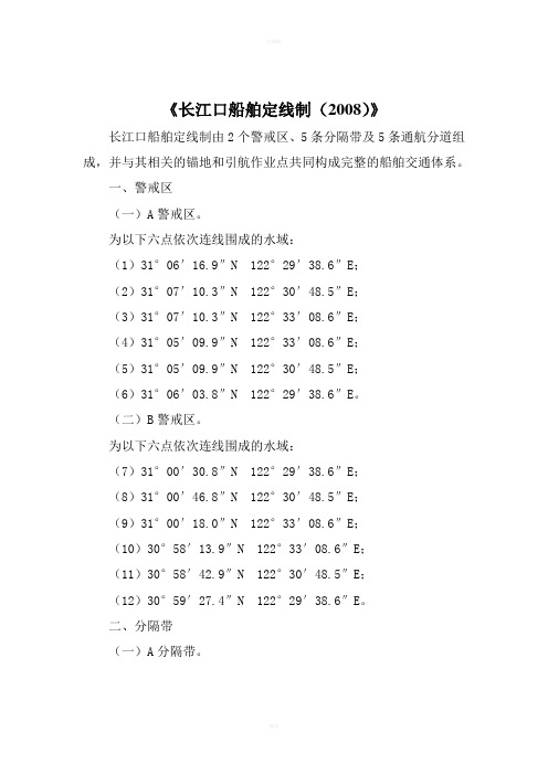
《长江口船舶定线制(2008)》长江口船舶定线制由2个警戒区、5条分隔带及5条通航分道组成,并与其相关的锚地和引航作业点共同构成完整的船舶交通体系。
一、警戒区(一)A警戒区。
为以下六点依次连线围成的水域:(1)31°06′16.9″N 122°29′38.6″E;(2)31°07′10.3″N 122°30′48.5″E;(3)31°07′10.3″N 122°33′08.6″E;(4)31°05′09.9″N 122°33′08.6″E;(5)31°05′09.9″N 122°30′48.5″E;(6)31°06′03.8″N 122°29′38.6″E。
(二)B警戒区。
为以下六点依次连线围成的水域:(7)31°00′30.8″N 122°29′38.6″E;(8)31°00′46.8″N 122°30′48.5″E;(9)31°00′18.0″N 122°33′08.6″E;(10)30°58′13.9″N 122°33′08.6″E;(11)30°58′42.9″N 122°30′48.5″E;(12)30°59′27.4″N 122°29′38.6″E。
二、分隔带(一)A分隔带。
A警戒区东侧以下四点依次连线围成的水域为A分隔带,该分隔带宽度为0.5海里,长度为1.94海里:(29)31°06′25.1″N 122°33′08.6″E;(30)31°06′25.1″N 122°35′24.4″E;(31)31°05′55.1″N 122°35′24.4″E;(32)31°05′55.1″N 122°33′08.6″E。
珠江口水域船舶定线制简介
《珠江口水域船舶定线制》简介广东海事局局长汪湘涛尊敬的洪部长、游省长、各位领导、各位来宾、同志们:现在,我代表广东海事局就《珠江口水域船舶定线制》(以下简称《定线制》)和《珠江口水域船舶报告制》向大家做简要介绍:一、《定线制》制定过程1999年底,全国通航管理工作会议部署广东海事局负责制定《定线制》。
我局高度重视该项工作,组织系统内的专家和业务骨干,在航海界专家的帮助下,利用广州船舶交通管理中心对珠江口船舶交通流进行全面观测,进一步摸清了船舶航行规律,研究切合实际的对策措施,于2001年底制定了初步方案,并几番斟酌,反复修改,期间,交通部领导多次对此项工作作出指示,提出要求;交通部海事局自始至终关注《定线制》的制定,多次派员对我局进行指导,最终形成了目前的方案。
制定工作还得到了部队的大力支持。
《定线制》水域内的锚地调整得到广州军区、广东省军区的及时批复,保证了《定线制》的顺利实施。
我局与香港海事处就《定线制》制定工作开展了密切的合作。
自2000年起,在粤港海事定期联系会议上,双方就《定线制》设定方案、公布方式、执法检查、信息共享等方面进行了广泛磋商;还多次召开双方专题研讨会,对方案的技术问题进行深入研究、协商。
《定线制》制定得到了港航单位、有关部门、航海教学科研单位的大力支持。
广东省交通厅、广州港务局、广东省航海学会、大连海事大学、广州远洋公司、广州海运集团等单位对《定线制》给予了极大的关注,多次派专家协助我局的工作。
本《定线制》凝聚了航海界许多专家的智慧和辛勤劳动。
二、《定线制》简介《定线制》由担杆水道定线制和大濠水道定线制两部分组成。
(一)担杆水道定线制担杆水道定线制由两段分道通航段和两个警戒区组成,第二警戒区与香港东博寮水道分道通航段相连接。
担杆水道定线制分道通航段的分隔带宽度0.5海里,分隔带两侧各0.5海里水域为通航分道。
北侧分道定为西行通航分道,南侧分道定为东行通航分道。
设定的两个警戒区,即第一警戒区和第二警戒区,第一警戒区为半径1.2海里的水域,第二警戒区为半径1.7海里的水域。
- 1、下载文档前请自行甄别文档内容的完整性,平台不提供额外的编辑、内容补充、找答案等附加服务。
- 2、"仅部分预览"的文档,不可在线预览部分如存在完整性等问题,可反馈申请退款(可完整预览的文档不适用该条件!)。
- 3、如文档侵犯您的权益,请联系客服反馈,我们会尽快为您处理(人工客服工作时间:9:00-18:30)。
成山角水域强制性船舶报告制/船舶定线制(经国际海事组织海上安全委员会第72届大会审议通过)SHIP REPORTING SYSTEM AND ROUTEING SYSTEM OFF THE CHENGSHAN JIAO PROMO NTORY(Adopted by MSC. 93(72), IMO)国际海事组织海上安全委员会MSC.93(72)号决议(2000年5月19日通过)强制性船舶报告制海上安全委员会,忆及《国际海事组织公约》第28条(b)有关委员会的职能,还忆及《1974年国际海上人命安全公约(SOLAS)》规则V/8-1款有关本组织通过的船舶报告制,进一步忆及授权本委员会代表本组织审议通过船舶报告制的职能的第A.858(20)号大会决议,考虑到海上安全委员会MSC.43(64)号决议通过的船舶报告制的指南和标准,审议了航行安全分委会第45次会议的建议案,1、根据SOLAS公约第V/8-1款,通过本决议附件中所述的成山角水域强制性船舶报告制;2、决定该强制性船舶报告制将于2000年12月1日世界时0时起生效;3、要求秘书长将本决议及其附件提请SOLAS公约成员国和缔约国予以注意。
(在此分页)RESOLUTION MSC. 93(72)(adopted on 19 May 2000)MANDATORY SHIP REPORTING SYSTEMTHE MARITIME SAFETY COMMITTEE,RECALLING Article 28(b) of the Convention on the International Maritime Organization concerning f unction of the Committee,RECALLING also regulation V/8-1 of the International Convention for the Safety of Life at Sea (S OLAS),1974 concerning the adoption by the Organization of ship reporting systems,RECALLING FURTHER resolution A.858(20) which authorizes the Committee to perform the fun ction of adopting ship reporting systems on behalf of the Organization,TAKING INTO ACCOUNT the Guidelines and criteria for ship reporting systems adopted by resol ution MSC.43 (64).HA VING CONSIDERED the recommendations of the Sub-Committee on Safety of Navigation at it s forty-fifth session.1. ADOPTS, in accordance with SOLAS regulation V/8-1, the mandatory ship reporting system off the Chengshan Jiao Promontory, as described in the Annex to the present resolution;2. DECIDES that the said mandatory ship reporting system will enter into force at 0000 hours UTC on 1 December 2000;3. REQUESTS the Secretary-General to bring this resolution and its Annex to the attention of Member Governments and Contracting Governments to the SOLAS Convention.(在此分页)成山角水域船舶定线制*(参考海图:中国版海图第9701、9304和9305。
注:这些海图基于(WGS84)数据)成山角水域船舶定线制由分道通航制、沿岸通航带和警戒区组成。
1、分道通航制1.1分隔带以下列地理位置的连线为中心线,宽度为两海里的水域:(1)37°31'.18N 122°45'.40E(2)37°25'.29N 122°49'.68E(3)37°11'.60N 122°49'.68E1.2分道通航制的内界线为下列地理位置的连线:(4)37°29'.69N 122°42'.13E(5)37°24'.49N 122°45'.91E(6)37°11'.60N 122°45'.91E1.3分道通航制的外边界线为下列地理位置的连线:(7)37°32'.69N 122°48'.68E(8)37°26'.09N 122°53'.46E(9)37°11'.60N 122°53'.46E1.4北行船舶通航分道为分隔带与分道通航制外边界线之间的水域,宽为2海里;主交通流为000°(真方向)和330°(真方向)。
1.5南行船舶通航分道为分隔带与分道通航制内边界线之间的水域,宽为2海里。
主交通流为150°(真方向)和180°(真方向)。
2、沿岸通航区沿岸通航带为分道通航制的内界线与邻近海岸之间的水域。
3、警戒区警戒区以37°34'.65N,122°42'.88E的地理位置为中心,半径为5海里的水域。
*注:该定线制与强制性船舶报告制一起均由国际海事组织海上安全委员会根据 A.858(20)决议审议通过。
(在此放示意图:成山角定线制示意图)(在此分页)成山角水域强制性船舶报告制1、适用的船舶要求参加该强制性船舶报告制的船舶:24米及以上的渔船、300总吨及以上的货船以及经修正的《1974年国际海上人命安全公约》第1章规定的客船。
2、适用的地理范围及相关海图的编号及版本地理覆盖范围是以船舶交管中心(VTS, 地理位置为37023′.65N,122042′.12E)为圆心,半径24海里的水域。
相关海图:中国版海图9701、9304和9305号。
海图参照世界测量系统(WGS84)基准。
3、报告格式、报告时间和位置,受理报告机关,可提供的服务3.1格式船舶报告制格式采用IMO A.851(20)号大会决议附则中所规定的格式。
A 船名、呼号和国际海事组织编码(若适用)C或D 位置(纬度和经度或相对于陆标的位置)E 航向F 航速G 始发港I 目的港(可选)Q 缺陷及限制(拖船应报告其拖带长度及被拖物名称)U 总长及总吨3.2报告内容及地理位置3.2.1船舶进入船舶报告制水域内应报告3.1项中的信息;如船舶驶离该水域则不要求报告。
3.2.2船舶驶离报告制水域内的港口时,应报告其船名、船位、驶离时间及目的港。
3.2.3船舶抵达报告制水域内的港口或锚地时,应在靠泊后或抵达后报告其船名、船位和抵达时间。
3.2.4在报告制水域内发生交通事故或污染事故时,船舶应立即报告事故的种类、时间、地点、损害或污染的程度以及是否需要援助,并应按照主管机关的要求提供与事故有关的其它信息。
3.3 主管机关主管机关为中华人民共和国山东海事局,呼叫名称为“成山角VTS中心”。
4、向船舶提供的信息及应遵守的程序4.1成山角VTS中心将视情况为参加报告制的船舶提供诸如冲突船舶交通、异常天气情况及海上安全等信息。
4.2船舶应在VTS指定的频率上保持守听。
5、报告制要求的无线电通讯,发送报告的频率和应报告的信息5.1 成山角VTS中心的工作频道:工作频道:8频道或9频道备用频道:65频道呼叫频道:16频道5.2报告制所用语言为中文或英文。
所有直接印字电报及无线电话通讯,均应按规定格式采用航海通讯用语。
6、报告制水域内实施的规定和规则为实施作为缔约国对其生效的国际公约,中国已采取了适当的措施,包括视情况进行了国内立法和通过国内法律颁布规章。
实施的相关法律还包括履行《1972年国际海上避碰规则》、《1974年国际海上人命安全公约》及《73/78防止船舶污染国际公约》等公约的国内立法及规定。
7、支持报告制运行的岸基设施7.1 成山角VTS中心的系统组成有:雷达系统、VHF通讯系统、VHF-DF系统、信息处理和显示系统、信息传输、记录、重放系统及水文气象传感系统。
其功能为:数据收集与评估、信息提供、助航服务、支持联合行动。
7.2 成山角VTS中心保持24小时不间断值班。
8、岸基机关的通讯设施发生故障时的替代通讯手段成山角VTS中心的每一个频道均为多接收器冗余设计。
船岸通讯替代方式为高频(单边带)、电传(传真)、电子邮件或移动电话。
9、对未能遵守报告制的船舶应采取的措施采取与国际法一致的适当措施确保报告制的实施。
(在此分页)Ship’s Routeing System* off the Chengshan Jiao Promontory(Reference charts: Chinese charts 9701, 9304, and 9305. Note: These charts are based on (WGS 84) Da tum)The ship’s routeing system in the waters off Chengshan Jiao promontory consists of the traffic separati on scheme, the inshore traffic zone and precautionary area.1.The traffic separation scheme1.1 The separation zone, two nautical miles wide, is centered upon the line connecting the following ge ographical positions:(1)37°31'.18 N 122°45'.40 E(2)37°25'.29 N 122°49'.68 E(3)37°11'.60 N 122°49'.68 E1.2 The inner limit of the traffic separation scheme is the line connecting the following geographical po sitions:(4)37°29'.69 N 122°42'.13E(5)37°24'.49 N 122°45'.91E(6)37°11'.60 N 122°45'.91E1.3 The outer limit of the traffic separation scheme is the line connecting the following geographical po sitions:(7)37°32'.69N 122°48'.68E(8)37°26'.09N 122°53'.46E(9)37°11'.60N 122°53'.46E1.4 The traffic lane for northbound traffic, two miles wide, is established between the separation zone a nd the outer limit of the traffic separation scheme. The main traffic directions are 0000(T) and 3300(T).1.5 The traffic lane for southbound traffic, two miles wide, is established between the separation zone and the inner limit of the traffic separation scheme. The main traffic directions are 1500(T) and 1800(T ).2.The inshore traffic zoneThe inshore traffic zone is the waters between the inner limit of the traffic separation scheme and the ad jacent coast.3.The precautionary areaThe precautionary area is the area with the geographical position37°34'.65N,122°42'.88E as the center and 5 miles as the radius.*Which,together with Mandatory Ship Reporting System, was adopted by MSC, IMO, in accordance with Re solution A.858 (20)(在此分页)MANDATORY SHIP REPORTING SYSTEM OFFTHE CHENGSHAN JIAO PROMONTORY1. Categories of ships required to participate in the systemThe following vessels are required to participate in the system: fishing vessels with a length of 24 mete rs and above, cargo ships of 300 gross tonnage and above, and passenger ships as defined in Chapter 1 of 1974 SOLAS, as amended.2. Geographical coverage of the system and the numbers and editions of the reference charts used for the delineation of the systemThe waters covered by the Ship Reporting System is the water area with the VTS center (geographical position is 37023′.65N,122042′.12E) as the center and 24 miles as the radius.The relevant charts are Chinese charts No. 9701, 9304 and 9305. Chart datum is World Geodetic Syste m 1984 (WGS 84) Datum.3. Format, reporting time and geographical positions for submitting reports, authority to whom the rep orts should be sent, available services3.1 FormatThe format for reporting is as set forth in paragraph 2 of the appendix to Assembly resolution A. 851 (20)A Name of ship, call sign, and IMO number (if applicable)C orD Position (latitude and longitude or in relation to a landmark)E CourseF SpeedG Port of departureI Port of destination (optional)Q Defects and limitation (vessels towing are to report length of tow and name of object in tow)U Overall length and gross tonnage3.2 Content and geographical position for submitting reports3.2.1 Participating vessels are to report the information in paragraph 3.1 when entering the ship reporti ng system area. Reports are not required when a participating vessel leaves the area.3.2.2 When a participating vessel leaves a port that is located within the reporting area, it shall report it s name, position, departure time, and port of destination.3.2.3 When a participating vessel arrives at a port or anchorage within the reporting area, it shall report, on arrival at its berth, its name, position, and arrival time.3.2.4 When a traffic incident or a pollution incident occurs within the reporting area, the vessel(s) shall immediately report the type, time, and location of the incident, extent of damage or pollution, and whet her assistance is needed. The vessel(s) shall provide any additional information related to the incident, as required by the shore-based authority.3.3 AuthorityThe competent authority is Shandong Maritime Safety Administration, China. The voice call sign is “C hengshan Jiao VTS Center”.4. Information to be provided to ships and procedures to be followed4.1 The Chengshan Jiao VTS Center, where appropriate, will provide participating vessels with informa tion such as conflicting vessel traffic, abnormal weather conditions, and maritime safety information.4.2 Participating vessels shall maintain a listening watch on the designated VTS frequency.5. Radiocommunications required for the system, frequencies on which reports should be transmitted a nd the information to be reported5.1 The working channels of the Chengshan Jiao VTS Center are:Primary-Channel 8 or 9Secondary-Channel 65Calling frequency-Channel 165.2 The language used for reports in the system will be Chinese or English. Marine Communication Ph rases in a prescribed format will be used in all direct-printing telegraphy and radiotelephony communic ations.6. Rules and regulations in force in the area of the systemChina has taken appropriate action to implement international conventions to which it is a party includi ng, where appropriate, adopting domestic legislation and promulgating regulations through domestic la w. Relevant laws in force include domestic legislation and regulations to implement the Convention on the International Regulations for Preventing Collisions at Sea, 1972, the International Convention for th e Safety of Life at Sea, 1974, and the International Convention for the Prevention of Pollution from Shi ps, 1973/19787. Shore-based facilities to support operation of the system7.1 Chengshan Jiao VTS Center is comprised of radar, VHF communications, VHF-DF, information pr ocessing and display, information transmission, recording, replay, and hydro-meteorological sensors. It s functions are data collection and evaluation, provision of information, navigation assistance, and supp ort to allied services.7.2 Chengshan Jiao VTS Center maintains a continuous 24 hour watch.8. Alternative communications if the communication facilities of the shore-based authority fails Chengshan Jiao VTS Center has built in redundancies with multiple receivers on each channel. Alternat ive means of ship to shore communication are by HF(SSB), telex (facsimile), e-mail, or cellular.9. Measures to be taken if a ship fails to complyAppropriate measures will be taken to enforce compliance with the system, consistent with internationa l law.。