地图题范文
英语考试作文-23日雅思写作小作文真题范文:地图题
英语考试作文23日雅思写作小作文真题范文:地图题小站雅思频道为大家带来2018年6月23日场的雅思小作文真题,本期小作文真题为地图题,内容为大学生物科学区的布局及未来的规划。
真题如下图。
最近地图题和流程图的出题率很高,各位即将参加雅思考试的考生请打起12分的精神,注意复习小作文地图题和流程图这两大题型。
小作文题目:The maps below show the bioscience area of a university campus as it is now and its development plan.Summarize the details. Select and report the main features and make comparisons where relevant.雅思小作文范文解析:地图描述的一个大学的生物科学区的现在的布局和将来的规划。
分段上可以前后各一段,也可以按照中间的walkway进行东西的区别进行写作,这里要着重的描述变化的内容,这里很多的不规则变化估计会是很多的同学的障碍,但是注意这个不是最重点的,可以顺带,不是必须。
最后提醒各位同学,地图和流程最近的考试频率很高,出现规律不定,建议要加强复习和练习。
雅思小作文高分表达Future planning clearedredevelopment are also predicted tonoticeable rearrangedexclusive use Further extensionenlarged at the cost of雅思小作文范文Those two maps reveal the present layout of the buildings and the future planning for the bioscience sector in the campus of a university.In the western part of the walkway, most trees are planned to be cleared with only a few left in the corner, which makes room for the redevelopment of the Bio-chemistry and the construction of a new road and the staff car park. In addition, Genetic 2 and the Bio-imaging are also predicted to be established to the north of the Lab.For the eastern part, changes are also noticeable. The car park now is going to be rearranged for the exclusive use of students’ car park. Further extension will also be found in the area of the Genetic, Lab and the Biotech buildings. Specifically, the Genetic is named Genetic 1 and the Biotech is enlarged two times compare to that in before.Overall, this field is likely to be more fully developed at the cost of reduction in plantations in order tospecify the functions and increase capacity.范文原创自小站老师Jeff. Lei,字数 173 words。
雅思小作文真题范文-:地图题范文
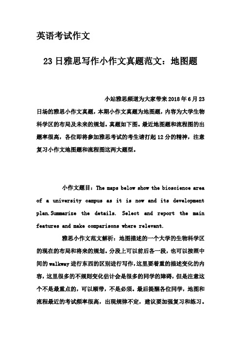
The maps below show the centre of a small town called Islip as it is now, and plans for its development.The diagrams illustrate some proposed changes to the central area of the town of Islip.It is clear that the principal change to the town will be the construction of a ring road around the centre. Various other developments with regard to shops and housing will accompany the building of this road.Looking at the map of Islip as it is now, we can see that a main road runs through its centre from east to west. The second map shows the planned pedestrianisation of this road. Traffic will be diverted on to a dual carriageway that will form a ring around the town centre.Currently there is a row of shops along either side of the main road. However, it appears that the shops along the north side of the new pedestrian street will be demolished to make way for a bus station, shopping centre, car park and new housing area. The shops along the south side of the street will remain, but it seems that thetown’s park will be reduced in size so that more new houses can be built within the ring road.(187 words, band 9)。
小作文地图题的高能写法

小作文地图题的高能写法1地图题第一幅图1、时态单图基本用一般现在时多图的第一幅图必须用过去时2、图片地理内容描写顺序单图基本用一般现在时多图的第一幅图必须用过去时3、写作内容先写这个地方主要区域有哪些,再写这个地方最明显的建筑物,以这个建筑物为圆心放射到四周的建筑4、词句准备表示“什么地方有”的意思:there be、we can see、lie、be located/ be situated (in/at)、can be found in the east/ west/ south/ north of ...表示方位的词句表方位in the eastern/ western/ southern northern part of ...;表方位in the southwestern corner of ... ;at the southern end of the river;表达在什么…对面Be opposite表达毗邻bordering; next to描述道路河流走向a main road/river run through…from…to…5、模板准备Clearly, the …in…, which was surrounded by…, can be divided into …main regions: Located in the center and the north were.... One was situated next to…, and the other was just opposite…,bordering …in the northeast. A main road ran through the entire …from the north to the south on the left-hand side of picture.6、例子分析由第二张图上我们可以看见,相对于第一幅图,第二幅图多了铁路,新建了桥,农田变少了,森林变少了,village home 住所多了。
2020最新雅思Task1写作范文地图题之超市规划

2020最新雅思Task1写作范文地图题之超市规划The map below is of the town of Garlsdon. A new supermarket (S) is planned for the town. The map shows two possible sites for the supermarket.该地图展示小镇Garlsdon的新超市的规划图,有2种可能选址。
请作答。
雅思图表小作文表地图题9分范文:The map shows two potential locations (S1 and S2) for a new supermarket in a town called Garlsdon.The main difference between the two sites is that S1 is outside the town, whereas S2 is in the town centre. The sites can also be compared in terms of access by road or rail, and their positions relative to three smaller towns.Looking at the information in more detail, S1 is in the countryside to the north west of Garlsdon, but it is close to the residential area of the town. S2 is also close to the housing area, which surrounds the town centre.There are main roads from Hindon, Bransdon and Cransdon to Garlsdon town centre, but this is a no traffic zone, so there would be no access to S2 by car. By contrast, S1 lies on the main road to Hindon, but it would be more difficult to reachfrom Bransdon and Cransdon. Both supermarket sites are close to the railway that runs through Garlsdon from Hindon to Cransdon.(171)附雅思小作文考官范文基本套路段一:话题重述段二:概括话题数据的主要特征或规律段三:详述特征规律一段四:详述特征规律二注意:simon考官主张雅思小作文无须总结!大家可留心这一点。
雅思流程图和地图题范文
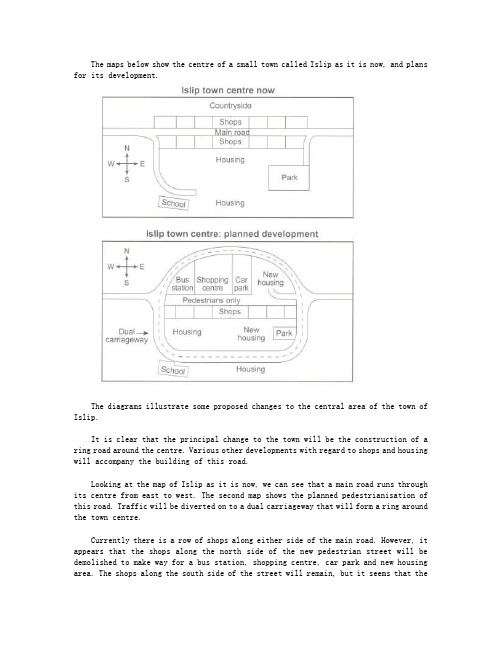
The diagram on the left illustrates the process by which cement is made whilst the diagram on the right shows us how concrete is made.We can clearly see that the first stage in cement production is to put two substances –limestone and clay –through a crusher to create a powder. This powder then goes through a mixer and is then heated in a rotating heater. Once the powder has gone through the mixer and heater, it is ground and the cement is packed into bags.The diagram on the right hand side tells us that concrete is a mixture of four ingredients in differing proportions. Cement makes up 15% of the mixture, water constitutes 10%, sand 25%, and gravel (i.e. small stones) 50%. These ingredients are mixed in a rotating concrete mixer to make concrete.In summary, the production of cement and the production of concrete appear to be fairly simple processes.左边的图描述的是水泥生产的流程,而右边的图则是混凝土生产的流程。
雅思地图题范文
雅思地图题范文雅思地图题是指考生需要描述和分析一幅地图的题目。
下面是一个关于雅思地图题的范文:The maps illustrate the changes that have taken place in a coastal area over a period of 60 years, between 1950 and 2010. The first map shows the area as it appeared in 1950, while the second map depicts the changes that have occurred by 2010.Overall, the most noticeable change is the development in the area. In 1950, the coast consisted mainly of natural features, including a sandy beach, some rocks, and a small area of vegetation. However, by 2010, the area had been transformed into a residential area with various buildings and infrastructure.In 1950, the beach occupied a large portion of the coastal area, extending from the northwest to the southeast. There were a few patches of vegetation scattered along the beach, particularly in the northeast corner. There were also a couple of rocks protruding from the water near the shore. On the other side of the beach, there was a small patch of flat land with some trees.By 2010, the beach had significantly reduced in size, with the sand giving way to residential buildings. In the northwest, there were a cluster of houses facing the beach, with a road running parallel to the coastline. Towards the southeast, there was a larger residential area, complete with a school, a shopping center, and a recreational park. The rocks that were present in 1950 had been removed to make way for a marina, where several boats and yachts weremoored.Furthermore, the area of vegetation in the northeast corner had been turned into a golf course, with well-manicured lawns and several ponds. The patch of flat land on the other side of the beach had been transformed into a golf driving range. In addition, a road had been constructed to connect the residential area to the rest of the city.In conclusion, the coastal area in question has undergone significant development over the past six decades. The beach has been overtaken by residential buildings, a marina has been built, and a large golf course and driving range have also been established.。
雅思地图小作文7分范文:村庄的变迁

雅思地图小作文 7 分范文:村庄的变迁地图题The map below shows the development of the village of Ryemouth between 1995 and present. Write a report based on the map.题目来源:2021 年 4 月29 日大陆雅思小作文1 题目大意下面的地图显示了从1995 年到现在Ryemouth 村的发展情况。
根据地图写一份报告。
2 高分范文示例开始段 - 改写题目The map given illustrates the reconstruction of the village of Ryemouth between 1995 and present.主体段段-1: 切割法---主路 1In 1995,there was a main road, extending from the northwest to the southeast,with several houses nearby. A small residental area can also be noticed in the middle block,linking to this road. To the east of this road were located the farmland and forest park. Currently, the residental block almost remain the same, while the original agriculture and natural scenery aresubstituted by the entertaining area dominated by golf and tennis.主体段 2: 切割法---主路 2Another street, stretching from the west to the east, was sited adjacent to the coast, which meets the main road with a hotel around the corner and a cafe opposite to it. Several shops and fish markets could be seen to the both sides of the street,while the fishing port can also be accessed in the past. However, the southern area has altered considerably since 1995. The original harbor is demolished, with the previous supporting facilities all replaced by restaurants and apartments respectively. It is noticeable that a parking lot is newly constructed just off the hotel.结尾:整体概述In summary,the function of infrastructures in the village has changed from serving agriculture and fishery to entertainment and related supporting facilities.。
地图题英语小作文

地图题英语小作文Certainly! Here's an essay on a map-related topic in English:Title: Exploring the World Through Maps。
Maps have been an integral part of human civilization for centuries, serving as essential tools for navigation, exploration, and understanding the world around us. From ancient cartography to modern digital mapping technologies, maps have evolved significantly, yet their fundamental purpose remains unchanged: to represent geographical features and spatial relationships. In this essay, we will explore the significance of maps and how they shape our understanding of the world.First and foremost, maps provide a visual representation of the Earth's surface, depicting its natural and human-made features such as mountains, rivers, cities, and roads. This visual depiction allows individualsto conceptualize spatial relationships and plan journeyswith greater ease and efficiency. Whether it's navigating through unfamiliar terrain or studying the layout of a city, maps serve as invaluable guides for travelers and explorers.Moreover, maps play a crucial role in education and research, enabling students and scholars to study geography, history, and various other disciplines. Historical maps, in particular, offer insights into past civilizations, trade routes, and geopolitical boundaries, shedding light on how societies have evolved over time. By analyzing maps, researchers can uncover patterns, trends, and connections that help deepen our understanding of human geography and cultural diversity.In addition to their practical utility, maps also hold symbolic and cultural significance. They often reflect the perspectives and biases of their creators, shaping how people perceive geographical regions and political boundaries. For example, maps produced during the age of colonialism often portrayed colonized territories as subordinate to the colonizers, reinforcing power dynamicsand colonial ideologies. Similarly, maps used in propaganda or nationalist movements may distort geographical realities to advance specific agendas.Furthermore, the advent of digital mapping technologies has revolutionized the way we interact with maps. Geographic Information Systems (GIS) allow for the creation, analysis, and visualization of spatial data on a computerized platform, enabling users to map complex phenomena such as population density, land use, and environmental change. These technologies have applicationsin diverse fields, including urban planning, environmental management, and disaster response.Despite the advancements in digital mapping,traditional cartography continues to thrive as an art form and cultural expression. Cartographers employ various techniques and styles to create visually stunning maps that capture the beauty and diversity of the Earth's landscapes. From antique maps adorned with intricate illustrations to modern topographic maps featuring precise contour lines, each map tells a unique story and invites exploration.In conclusion, maps serve as indispensable tools for navigation, education, and cultural expression. They enable us to explore the world around us, understand its complexities, and appreciate its beauty. Whether in physical or digital form, maps continue to shape our perception of the Earth and inspire curiosity and wonder about the world we inhabit. As we continue to innovate and advance in the field of cartography, the journey of exploration and discovery facilitated by maps will only continue to evolve.。
- 1、下载文档前请自行甄别文档内容的完整性,平台不提供额外的编辑、内容补充、找答案等附加服务。
- 2、"仅部分预览"的文档,不可在线预览部分如存在完整性等问题,可反馈申请退款(可完整预览的文档不适用该条件!)。
- 3、如文档侵犯您的权益,请联系客服反馈,我们会尽快为您处理(人工客服工作时间:9:00-18:30)。
The map below shows a number of different ways of visiting Mountain Eron in a national park
This map is a road map which generally introduces the layout of the viewing areas and the important facilities of the scenic area of Mountain Eron.
Cultural center is the first stop of every tourist as it is just beside the main driving track which links this scenic region to the outside world.Then there a fork road whose3branches leading to different areas
For tourists willing to enjoy the view of sunrise or sunset,the best transportation tool is vehicles. To view sunrise,choose the right track of the fork road-a driving track heading to the mountain –and then turn right at the first intersection.To see sunset,then the left track of the fork road is your choice,which is also a driving track but leads to the sunset viewing area.
People willing to climb the mountain have two choices.One is the middle of the fork road,which is a path that only allows for walk.After walking to the left side of the mountain foot and see the toilets and the first aid point,you will find the climbing track right in the front.Another choice is to take vehicles,you will first follow the choice of those going to view the sunrise,but then turn left until you reach the entrance of the climbing track.。