Modeling
Geometric Modeling
Geometric ModelingGeometric modeling is a crucial aspect of computer graphics and design, allowing for the creation of realistic and visually appealing 3D models. It involves the representation of geometric shapes and structures in a digital format, which can then be manipulated and rendered on a computer screen. Geometric modeling is used in a wide range of applications, including video games, animation, virtual reality, and industrial design. One of the key benefits of geometric modeling is its ability to accurately represent complex shapes and structures that would be difficult or impossible to create by hand. By using mathematicalequations and algorithms, designers can create detailed and realistic 3D modelsthat can be viewed from any angle and manipulated in real-time. This level of precision and flexibility is essential for many modern design projects, where accuracy and realism are paramount. In addition to its practical applications, geometric modeling also plays a crucial role in the artistic and creative process. Designers and artists can use geometric modeling tools to explore new ideas, experiment with different shapes and forms, and push the boundaries of traditional design aesthetics. By combining mathematical precision with artistic vision, geometric modeling allows for the creation of stunning and innovative visual experiences that captivate and inspire audiences. Furthermore, geometric modeling is an essential tool for collaboration and communication in design and engineering fields. By creating digital models that can be easily shared and manipulated, designers and engineers can work together more effectively, exchanging ideas and feedback in real-time. This collaborative approach not only streamlines the design process but also ensures that all stakeholders are on the same page, reducing the risk of miscommunication and errors. Moreover, geometric modeling has revolutionized the manufacturing industry, allowing for the rapid prototyping and production of complex parts and components. By creating digital models of products and machines, engineers can simulate their behavior under various conditions, identify potential issues, and make necessary adjustments before moving to production. This level of virtual testing and validation not only saves time and money but also improves the overall quality and reliability of the final product. Overall, geometric modeling is a versatile and powerful tool that has transformedthe way we design, create, and communicate. From its practical applications in computer graphics and engineering to its artistic and creative potential, geometric modeling continues to push the boundaries of what is possible in the world of design. By embracing this technology and harnessing its capabilities, designers and engineers can unlock new opportunities for innovation and discovery, shaping the future of design and manufacturing for years to come.。
Modeling,Simulat...

Book reviewModeling,Simulation,and Control of Flexible Manufacturing Systems ±A Petri Net Approach;Meng Chu Zhou;Kurapati Venkatesh;Yushun Fan;World Scienti®c,Singapore,19991.IntroductionA ¯exible manufacturing system (FMS)is an automated,mid-volume,mid-va-riety,central computer-controlled manufacturing system.It can be used to produce a variety of products with virtually no time lost for changeover from one product to the next.FMS is a capital-investment intensive and complex system.In order to get the best economic bene®ts,the design,implementation and operation of FMS should be carefully made.A lot of researches have been done regarding the modeling,simulation,scheduling and control of FMS [1±6].From time to time,Petri net (PN)method has also been used as a tool by di erent researcher in studying the problems regarding the modeling,simulation,scheduling and control of FMS.A lot of papers and books have been published in this area [7±14].``Modeling,Simulation,and Control of Flexible Manufacturing Systems ±A PN Approach''is a new book written by Zhou and Venkatesh which is focused on studying FMS using PN as a systematic method and integrated tool.The book's contents can be classi®ed into four parts.The four parts are introduction part (Chapter 1to Chapter 4),PNs application part (Chapter 5to Chapter 8),new research results part (Chapter 9to Chapter 13),and future development trend part (Chapter 14).In the introduction part,the background,motivation and objectives of the book are described in Chapter 1.The brief history of manufacturing systems and PNs is also presented in Chapter 1.The basic de®nitions and problems in FMS design and implementation are introduced in Chapter 2.The authors divide FMS related problems into two major areas ±managerial and technical.In Chapter 4,basic de®nitions,properties,and analysis techniques of PNs are presented,Chapter 4can be used as the fundamentals of PNs for those who are not familiar with PN method.In Chapter 3,the authors presented their approach to studying FMS related prob-lems,the approach uses PNs as an integrated tool and methodology in FMS design and implementation.In Chapter 3,various applications in modeling,analysis,sim-ulation,performance evaluation,discrete event control,planning and scheduling of FMS using PNs are presented.Through reading the introduction part,the readers can obtain basic concepts and methods about FMS and PNs.The readers can also get a clear picture about the relationshipbetween FMS and PNs.Mechatronics 11(2001)947±9500957-4158/01/$-see front matter Ó2001Elsevier Science Ltd.All rights reserved.PII:S 0957-4158(00)00057-X948Book review/Mechatronics11(2001)947±950The second part of the book is about PNs applications.In this part,various applications of using PNs in solving FMS related problems are introduced.FMS modeling is the basis for simulation,analysis,planning and scheduling.In Chapter5, after introduction of several kinds of PNs,a general modeling method of FMS using PNs is given.The systematic bottom-up and top-down modeling method is pre-sented.The presented method is demonstrated by modeling a real FMS cell in New Jersey Institute of Technology.The application of PNs in FMS performance analysis is introduced in Chapter 6.The stochastic PNs and the time distributions are introduced in this Chapter. The analysis of a¯exible workstation performance using the PN tool called SPNP developed at Duke University is given in Section6.4.In Chapter7,the procedures and steps involved for discrete event simulation using PNs are discussed.The use of various modeling techniques such as queuing network models,state-transition models,high-level PNs,object-oriented models for simulations are brie¯y explained.A software package that is used to simulate PN models is introduced.Several CASE tools for PNs simulations are brie¯y intro-duced.In Chapter8,PNs application in studying the di erent e ects between push and pull paradigms is shown.The presented application method is useful for the selection of suitable management paradigm for manufacturing systems.A manufacturing system is modeled considering both push and pull paradigms in Section8.3which is used as a practical example.The general procedures for performance evaluation of FMS with pull paradigm are given in Section8.4.The third part of the book is mainly the research results of the authors in the area of PNs applications.In Chapter9,an augmented-timed PN is put forward. The proposed method is used to model the manufacturing systems with break-down handling.It is demonstrated using a¯exible assembly system in Section9.3. In Chapter10,a new class of PNs called Real-time PN is proposed.The pro-posed PN method is used to model and control the discrete event control sys-tems.The comparison of the proposed method and ladder logic diagrams is given in Chapter11.Due to the signi®cant advantages of Object-oriented method,it has been used in PNs to de®ne a new kind of PNs.In Chapter12,the authors propose an Object-oriented design methodology for the development of FMS control software.The OMT and PNs are integrated in order to developreusable, modi®able,and extendible control software.The proposed methodology is used in a FMS.The OMT is used to®nd the static relationshipamong di erent objects.The PN models are formulated to study the performance of the FMS.In Chapter12,the scheduling methods of FMS using PNs are introduced.Some examples are presented for automated manufacturing system and semiconductor test facility.In the last Chapter,the future research directions of PNs are pointed out.The contents include CASE tool environment,scheduling of large production system,su-pervisory control,multi-lifecycle engineering and benchmark studies.Book review/Mechatronics11(2001)947±950949 mentsAs a monograph in PNs and its applications in FMS,the book is abundant in contents.Besides the rich knowledge of PNs,the book covers almost every aspects regarding FMS design and analysis,such as modeling,simulation,performance evaluation,planning and scheduling,break down handling,real-time control,con-trol software development,etc.So,the reader can obtain much knowledge in PN, FMS,discrete event system control,system simulation,scheduling,as well as in software development.The book is a very good book in the combinations of PNs theory and prac-tical applications.Throughout the book,the integrated style is demonstrated.It is very well suited for the graduate students and beginners who are interested in using PN methods in studying their speci®c problems.The book is especially suited for the researchers working in the areas of FMS,CIMS,advanced man-ufacturing technologies.The feedback messages from our graduate students show that compared with other books about PNs,this book is more interested and easy to learn.It is easy to get a clear picture about what is PNs method and how it can be used in the FMS design and analysis.So,the book is a very good textbook for the graduate students whose majors are manufacturing systems, industrial engineering,factory automation,enterprise management,and computer applications.Both PNs and FMS are complex and research intensive areas.Due to the deep understanding for PNs,FMS,and the writing skills of the authors,the book has good advantages in describing complex problems and theories in a very easy read and understandable fashion.The easy understanding and abundant contents enable the book to be a good reference book both for the students and researchers. Through reading the book,the readers can also learn the new research results in PNs and its applications in FMS that do not contained in other books.Because the most new results given in the book are the study achievements of the authors,the readers can better know not only the results,but also the background,history,and research methodology of the related areas.This would helpthe researchers who are going to do the study to know the state-of-art of relevant areas,thus the researchers can begin the study in less preparing time and to get new results more earlier.As compared to other books,the organization of the book is very application oriented.The aims are to present new research results in FMS applications using PNs method,the organization of the book is cohesive to the topics.A lot of live examples have reinforced the presented methods.These advantages make the book to be a very good practical guide for the students and beginners to start their re-search in the related areas.The history and reference of related research given in this book provides the reader a good way to better know PNs methods and its applications in FMS.It is especially suited for the Ph.D.candidates who are determined to choose PNs as their thesis topics.950Book review/Mechatronics11(2001)947±9503.ConclusionsDue to the signi®cant importance of PNs and its applications,PNs have become a common background and basic method for the students and researchers to do re-search in modeling,planning and scheduling,performance analysis,discrete event system control,and shop-¯oor control software development.The book under re-view provides us a good approach to learn as well as to begin the research in PNs and its application in manufacturing systems.The integrated and application oriented style of book enables the book to be a very good book both for graduate students and researchers.The easy understanding and step-by-step deeper introduction of the contents makes it to be a good textbook for the graduate students.It is suited to the graduated students whose majors are manufacturing system,industrial engineering, enterprise management,computer application,and automation.References[1]Talavage J,Hannam RG.Flexible manufacturing systems in practice:application,design,andsimulation.New York:Marcel Dekker Inc.;1988.[2]Tetzla UAW.Optimal design of¯exible manufacturing systems.New York:Springer;1990.[3]Jha NK,editor.Handbook of¯exible manufacturing systems.San Diego:Academic Press,1991.[4]Carrie C.Simulation of manufacturing.New York:John Wiley&Sons;1988.[5]Gupta YP,Goyal S.Flexibility of manufacturing systems:concepts and measurements.EuropeanJournal of Operational Research1989;43:119±35.[6]Carter MF.Designing¯exibility into automated manufacturing systems.In:Stecke KE,Suri R,editors.Proceedings of the Second ORSA/TIMS Conference on FMS:Operations Research Models and Applications.New York:Elsevier;1986.p.107±18.[7]David R,Alla H.Petri nets and grafcet.New York:Prentice Hall;1992.[8]Zhou MC,DiCesare F.Petri net synthesis for discrete event control of manufacturing systems.Norwell,MA:Kluwer Academic Publishers;1993.[9]Desrochers AA,Al-Jaar RY.Applications of petri nets in manufacturing systems.New York:IEEEPress;1995.[10]Zhou MC,editor.Petri nets in¯exible and agile automation.Boston:Kluwer Academic Publishers,1995.[11]Lin C.Stochastic petri nets and system performance evaluations.Beijing:Tsinghua University Press;1999.[12]Peterson JL.Petri net theory and the modeling of systems.Englewood Cli s,NJ:Prentice-Hall;1981.[13]Resig W.Petri nets.New York:Springer;1985.[14]Jensen K.Coloured Petri Nets.Berlin:Springer;1992.Yushun FanDepartment of Automation,Tsinghua UniversityBeijing100084,People's Republic of ChinaE-mail address:*****************。
Building Information Modeling

BIM的全拼是Building Information Modeling,中文翻译最为贴切的、也被大家所认可的名称为:建筑信息模型。
这些建筑模型的数据在建筑信息模型中的存在是以多种数字技术为依托,从而以这个数字信息模型作为各个建筑项目的基础,去进行各个相关工作。
建筑工程与之相关的工作都可以从这个建筑信息模型中拿出各自需要的信息,即可指导相应工作又能将相应工作的信息反馈到模型中。
建筑信息模型不是简单的将数字信息进行集成,它还是一种数字信息的应用,并可以用于设计、建造、管理的数字化方法,这种方法支持建筑工程的集成管理环境,可以使建筑工程在其整个进程中显著提高效率、大量减少风险。
在建筑工程整个生命周期中,建筑信息模型可以实现集成管理,因此这一模型既包括建筑物的信息模型,同时又包括建筑工程管理行为的模型。
将建筑物的信息模型同建筑工程的管理行为模型进行完美的组合。
因此在一定范围内,建筑信息模型可以模拟实际的建筑工程建设行为,例如:建筑物的日照、外部维护结构的传热状态等。
同时BIM可以四维模拟实际施工,以便于在早期设计阶段就发现后期真正施工阶段所会出现的各种问题,来提前处理,为后期活动打下坚固的基础。
在后期施工时能作为施工的实际指导,也能作为可行性指导,以提供合理的施工方案及人员,材料使用的合理配置,从而来最大范围内实现资源合理运用。
当前建筑业已步入计算机辅助技术的引入和普及,例如CAD的引入,解决了计算机辅助绘图的问题。
而且这种引入受到了建筑业业内人士大力欢迎,良好地适应建筑市场的需求,设计人员不再用手工绘图了,同时也解决了手工绘制和修改易出现错误的弊端。
在“对图”时也不再用落后的将各专业的硫酸图纸进行重叠式的对图了。
这些CAD图形可以在各专业中进行相互的利用。
给人们带来便捷的工作方式,减轻劳动强度,所以计算机辅助绘图一直在受到人们的热烈欢迎。
其他方面的特点,在此就不再列举了。
特点那么BIM建筑信息模型也同CAD一样,也只是个设计绘图软件或者出图工具吗?对于这个问题,我们需要真正的认识BIM了。
Geometric Modeling

Geometric ModelingGeometric modeling plays a crucial role in various fields such as computer-aided design (CAD), computer graphics, architecture, and engineering. It involves the creation of digital representations of objects and environments using mathematical and computational techniques. Geometric modeling enables designers, engineers, and artists to visualize, simulate, and analyze complex shapes and structures, leading to innovative solutions and advancements in various industries. One of the key aspects of geometric modeling is its application in CAD software. CAD systems are extensively used in industrial design, mechanical engineering, and architecture for creating precise 2D and 3D models of products and buildings. Geometric modeling techniques such as wireframe, surface, and solid modeling are employed to define the shape, size, and geometric properties of the objects. This enables designers and engineers to iterate through multiple design concepts,analyze the behavior of components, and optimize the overall performance of the products. In the realm of computer graphics and animation, geometric modelingplays a pivotal role in creating realistic visual effects and immersive virtual environments. 3D modeling techniques are used to generate lifelike characters, environments, and special effects in movies, video games, and virtual simulations. By manipulating geometric primitives such as vertices, edges, and polygons,artists and animators can bring imaginary worlds to life, captivating audiencesand evoking emotional responses. Moreover, geometric modeling finds applicationsin the field of computational geometry, where algorithms and data structures are developed to solve geometric problems. From determining the intersection of geometric shapes to optimizing the arrangement of objects in space, computational geometry plays a vital role in areas such as robotics, geographic information systems, and computer-aided manufacturing. The efficiency and accuracy ofgeometric algorithms directly impact the performance and reliability of various technological systems. From a mathematical perspective, geometric modelinginvolves the representation of objects using mathematical equations and transformations. Concepts from linear algebra, calculus, and differential geometry are employed to describe the shape, curvature, and topology of geometric entities. This mathematical foundation not only provides a rigorous framework for modelingand analysis but also fosters interdisciplinary research at the intersection of mathematics, computer science, and engineering. In the realm of industrial design and manufacturing, geometric modeling facilitates the rapid prototyping and production of custom parts and assemblies. By leveraging 3D printing and computer numerical control (CNC) machining, designers can translate digital models into physical objects with high precision and complexity. Geometric modeling enables the seamless transition from virtual designs to tangible products, accelerating innovation and customization in the manufacturing industry. In conclusion, geometric modeling is a multifaceted discipline that permeates various domains, from engineering and computer graphics to mathematics and manufacturing. Its impact is evident in the way we design, visualize, and fabricate objects and environments, shaping the future of technology and creativity. As geometric modeling continues to evolve, driven by advances in computational power and interdisciplinary collaboration, it holds the promise of unlocking new frontiers in design, simulation, and fabrication.。
MathematicalModeling理论建模及实际应用
MathematicalModeling理论建模及实际应用数学建模(Mathematical Modeling)是一种将实际问题转化为数学问题,并通过数学方法对问题进行分析和解决的方法。
它既是数学的一种应用,也是一种研究问题并解决问题的工具。
数学建模在各个领域都有广泛的应用,如物理学、经济学、生物学、环境科学等等。
本文将从理论建模和实际应用两个方面来介绍数学建模的基本概念、方法以及一些实际应用案例。
在数学建模中,理论建模是首要的一步。
理论建模是指对实际问题进行分析和抽象,从中提取出数学模型的基本要素和关系。
对于一个复杂的实际问题,我们需要通过对问题的认识和理解,找出其中的关键因素和变量,并确定它们之间的数学关系。
这些关系可以是线性的、非线性的、离散的或连续的,可以用代数方程、微分方程、差分方程或概率统计等形式来表示。
理论建模需要深入地了解问题的背景和相关领域的知识,同时还需要灵活运用数学方法和工具来描述问题和解决问题。
数学建模的方法主要包括定性分析、定量分析和验证分析。
定性分析是指通过观察和分析问题的特征和特性,对问题进行描述和理解,找出问题的关键因素和变量,并确定它们之间的关系。
定量分析是指通过运用数学方法和工具,对问题进行计算和求解,得出问题的数值结果和解决方案。
验证分析是指对数学模型的有效性和可靠性进行检验和验证,通过与实际数据进行对比和比较,评估模型的拟合程度和预测能力。
这些方法相互补充和支持,共同构建了一个完整的数学建模流程。
数学建模在实际应用中有着广泛的应用。
以物理学为例,物理学中的很多问题都可以通过数学建模来解决。
比如,天体物理学中的行星运动、星系演化等问题可以通过数学建模来描述行星和星系的位置、速度和质量等参数,进而研究它们的运动规律和相互作用。
在经济学中,数学建模可以用来描述和分析经济系统中的供需关系、利润最大化、成本最小化等问题,从而指导经济政策和决策。
在生物学中,数学建模可以用来描述生物种群的增长、遗传变异、物种竞争等问题,为生态保护和资源管理提供科学依据。
Geometric Modeling

Geometric ModelingGeometric modeling is a crucial aspect of computer-aided design (CAD) and computer graphics. It involves the creation of digital representations of physical objects, which can be used for various purposes such as visualization, analysis, and manufacturing. Geometric modeling plays a significant role in industries such as architecture, engineering, and entertainment, where accurate and detailed representations of objects are essential. One of the key challenges in geometric modeling is achieving a balance between accuracy and efficiency. Creating highly detailed geometric models can be computationally expensive and time-consuming, especially when dealing with complex shapes and structures. On the other hand, simplifying the models to improve efficiency may result in loss of important details and accuracy. Finding the right balance between these two factors is crucial for ensuring that geometric models are both visually appealing and practical for their intended use. Another important consideration in geometric modeling is the representation of curved surfaces. While straight lines and simple shapes can be easily represented using basic geometric primitives such as points, lines, and polygons, representing curved surfaces requires more advanced techniques. One common approach is to use parametric curves and surfaces, which are defined by mathematical equations and can accurately represent complex curved shapes. However, working with parametric curves and surfaces can be challenging, requiring a deep understanding of mathematical concepts and computational algorithms. In addition to accuracy and representation of curved surfaces, geometric modeling also involves considerations of interoperability and data exchange. In many real-world applications, geometric models need to be shared and used across different software platforms and systems. Ensuring that geometric models can be accurately imported and exported between different software applications is crucial for seamless collaboration and workflow integration. This often requires adherence to industry standards and the use of common file formats for geometric data exchange. Furthermore, geometric modeling also involves considerations of dimensionality and spatial relationships. In many cases, geometric models need to represent three-dimensional objects and their spatial relationships in a realistic and intuitive manner. This requires the use oftechniques such as 3D modeling, spatial indexing, and spatial reasoning to accurately capture the spatial characteristics of physical objects. Additionally, geometric modeling often involves the manipulation and transformation of geometric objects, such as scaling, rotation, and translation, which further adds to the complexity of the modeling process. Moreover, geometric modeling is not onlyabout creating static representations of objects, but also about simulating dynamic behaviors and interactions. In many applications, such as virtual reality, video games, and simulations, geometric models need to accurately represent the dynamic behavior of objects in response to external forces and interactions. This requires the use of techniques such as physics-based modeling, collision detection, and rigid body dynamics to accurately simulate the behavior of objects in avirtual environment. In conclusion, geometric modeling is a complex and multifaceted field that plays a crucial role in various industries and applications. It involves a wide range of considerations, including accuracy, efficiency, representation of curved surfaces, interoperability, dimensionality, spatial relationships, and dynamic behaviors. Addressing these considerations requires a deep understanding of mathematical concepts, computational algorithms, and industry standards, as well as a creative and intuitive approach to capturing the visual and behavioral characteristics of physical objects. Despite its challenges, geometric modeling continues to advance and evolve, driven by the increasing demand for realistic and interactive digital representations of the physical world.。
Geometric Modeling

Geometric ModelingGeometric modeling is a fundamental aspect of computer-aided design and computer graphics. It involves the creation of digital representations of physical objects and shapes using mathematical equations and algorithms. Geometric modeling plays a crucial role in various industries, including manufacturing, architecture, entertainment, and scientific research. It enables designers and engineers to visualize, analyze, and manipulate complex geometries, ultimately leading to the development of innovative products and solutions. One of the key perspectives to consider when discussing geometric modeling is its significance in the field of engineering. Engineers rely on geometric modeling to design and simulate mechanical components, structures, and systems. By creating accurate 3D models of their designs, engineers can assess factors such as strength, durability, and performance, leading to the development of safer and more efficient products. Geometric modeling also facilitates the process of prototyping and testing, allowing engineers to identify and address potential issues before moving into production. In the realm of architecture and construction, geometric modeling plays a critical role in the design and visualization of buildings and infrastructure. Architects use geometric modeling software to create detailed 3D models of their designs, enabling them to explore different concepts, analyze spatial relationships, and communicate their ideas effectively. This technology also allows for the generation of realistic renderings and virtual walkthroughs, providing clients and stakeholders with a clear understanding of the proposed project. Additionally, geometric modeling supports the integration of building information modeling (BIM), which enhances collaboration and coordination among various disciplines involved in the construction process. Another perspective to consider is the impact of geometric modeling in the entertainment industry, particularly in the creation of digital content for films, video games, andvirtual reality experiences. Artists and animators utilize geometric modelingtools to sculpt and manipulate virtual characters, environments, and special effects. This process involves the use of polygons, curves, and surfaces to define the shape and appearance of digital assets. The level of detail and realism achievable through geometric modeling contributes to the immersive and visuallystunning nature of modern entertainment media. Moreover, geometric modeling is a crucial element in the advancement of scientific research and technological innovation. In fields such as medical imaging, geospatial analysis, and computational fluid dynamics, geometric modeling enables researchers to analyze and interpret complex data, leading to discoveries and breakthroughs in their respective domains. For instance, in medical applications, geometric modeling is used to reconstruct and visualize anatomical structures from imaging data, supporting diagnosis, treatment planning, and medical education. From a personal standpoint, as a designer and enthusiast of computer graphics, I have experienced the transformative power of geometric modeling in my creative endeavors. Theability to sculpt and manipulate digital forms has allowed me to bring my imagination to life, whether it's designing futuristic vehicles, otherworldly landscapes, or intricate mechanical assemblies. The process of working with geometric modeling tools is not just a technical exercise but a deeply immersive and expressive journey, where every vertex and edge contributes to the realization of a unique vision. In conclusion, geometric modeling is a multifaceted and indispensable tool that permeates various industries and creative pursuits. Its impact extends beyond the realms of design and engineering, influencing the way we perceive and interact with the world around us. As technology continues to evolve, geometric modeling will undoubtedly play a central role in shaping the future of innovation, art, and human expression.。
SOLID MODELING翻译
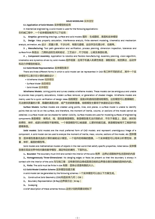
SOLID MODELING实体造型6.1 Application of Solid Models实体模型的应用In mechanical engineering, a solid model is used for the following applications:在机械工程中,一个实体模型被用于以下应用:1、Graphics: generating drawings, surface and solid models图形:生成图纸,表面和实体模型2、Design: Mass property calculation, interference analysis, finite element modeling, kinematics and mechanism analysis, animation, etc.设计:质量计算、干涉分析、有限元建模、运动学及机理分析、动画等。
3 、Manufacturing: Tool path generation and verification, process planning, dimension inspection, tolerance and surface finish.制造业:刀具轨迹的生成和验证,工艺设计,尺寸检验,公差及表面处理。
4 、Component Assembly: Application to robotics and flexible manufacturing: Assembly planning, vision algorithm, kinematics and dynamics driven by solid models.组件组装:应用于机器人和柔性制造:装配规划,视觉算法,运动学和动力学模型的驱动。
6.2 Solid Model Representation实体模型表示There are three different forms in which a solid model can be represented in CAD:有三种不同的形式,其中一个实体模型可以表示在计算机辅助设计:·Wireframe Model线架模型·Surface Model曲面模型·Solid Model实体模型Wireframe Models: Joining points and curves creates wireframe models. These models can be ambiguous and unable to provide mass property calculations, hidden surface removal, or generation of shaded images. Wireframe models are mainly used for a quick verification of design ideas.线框模型:连接点和曲线创建线框模型。
- 1、下载文档前请自行甄别文档内容的完整性,平台不提供额外的编辑、内容补充、找答案等附加服务。
- 2、"仅部分预览"的文档,不可在线预览部分如存在完整性等问题,可反馈申请退款(可完整预览的文档不适用该条件!)。
- 3、如文档侵犯您的权益,请联系客服反馈,我们会尽快为您处理(人工客服工作时间:9:00-18:30)。
Modeling of ecosystems as a data source for real-time terrainrenderingJohan HammesPO Box 1354Stellenbosch7599South AfricaFax: +27 21 880 1936Telephone:+27 21 880 1880Abstract. With the advances in rendering hardware, it is possible to render very complex scenes inreal-time. In general, computers do not have enough memory to store all the necessary information forsufficiently large areas. This paper discusses a way in which well-known techniques for modelingecosystems can be applied to generate the placement of plants on a terrain automatically at run-time.Care was taken to pick algorithms that would be sufficiently fast to allow real-time computation, butalso varied enough to allow for natural looking placement of plants and ecosystems while remainingdeterministic. The techniques are discussed within a specific rendering framework, but can easily beadapted to other rendering engines.Keywords: ecosystem modeling, ecotope modeling, compression, real-time rendering, terrain modeling, terrain visualization1 IntroductionWith the advances in rendering hardware, it is possible to render very complex scenes in real-time. Scenes of up to 200 000 triangles are becoming possible with much more complex scenes looming in the near future. The ability to render very complex scenes necessitates databases that can supply the rendering engine with enough data.Landscapes for flight simulators, games or visualization, poses a problem due to the large amounts of plants found on them. It is not uncommon for a flight simulator to have 500 million big trees in its database area, and countless smaller trees and shrubs. Due to the scale, and the amount of memory needed to hold the information, these trees have in general been left out of the simulation, or incorporated into the textures. In this paper, a system of ecotope1 modeling, that calculates the plants in the view frustum in real-time, is presented.The exact placements of these plants are seldom known, and seldom of real importance. For vast areas of countryside they add to the general feeling of realism. This lends itself to the modeling of ecosystems to determine the placement of plants. By modeling the ecosystems, and generating only the plants in the immediate vicinity, the overhead of storing millions of plants in memory can be avoided.Ecotopes are a good predictor of ecosystems. Rather than modeling the ecosystems (modeling the complex interactions between plants), ecotopes are modeled and the landscape is populated with representative ecosystems.Fig. 1. Two images created by Sam Bowling, using the World Construction Set [1] by 3D Nature. It shows the realistic natural scenery that can be generated with ecotope modelingBy using the basic parameters of elevation, relative elevation, slope, slope direction and multi fractal noise, it is possible to generate ecotope information that can be used to predict the ecosystems. An ecosystem is assigned a probability that it will exist as a function of the above five parameters. By evaluating them at a particular position in the world it is possible to find a probability for each ecosystem. The ecosystem with the highest probability is assigned to that particular area.The appearance of each ecosystem is defined in advance. This includes descriptions of the type, frequency and placement of plants, as well as typical ground cover. This information is used to build a representation of the ecosystem. The information is passed on to the rendering engine where it is cached, and reused for all subsequent frames that look at the same area.1 Ecotope : A particular habitat within a region with relative uniform climatological and soil conditions. Typically, specific ecotopes will be associated with specific ecosystems.In section 3, the framework that is used to render the scenery is discussed. The definition of ecosystems and modeling of ecotopes is structured around this. Section 4 looks at common parameters that is used to model ecotopes and ecosystems. In section 5 this is extended to show how ecosystems can be constructed to fit into the rendering framework. In section 6 the algorithms that is used to calculate the ecotopes and build a representative ecosystem is presented. I also look at some optimizations that are necessary for real-time performance. Section 7 looks at the results and is followed by a conclusion in section 8.2 BackgroundMost of my previous work dealt with large-scale terrain visualization for both commercial, gaming and military flight simulators. As rendering speeds increased it became possible to add more and more objects into the terrain adding to the realism. At first it was adequate to develop off-line tools to place objects and store them in the database. With the current commercial rendering capacity far exceeding one million triangles per second, it is impossible to store all the objects in a limited amount of RAM. A way had to be found to efficiently compress this data and extract only the data in the immediate vicinity of the camera in real-time.When viewing natural features it is the general patterns that define the area, rather than the exact detail. The specific position of a plant does not define a natural scene, but the relative placement due to competition for natural resources is very important. Ecosystem and ecotope modeling constitutes a form of compression for natural environments. While the exact position and type of plants are not preserved, the general statistical properties remain, allowing a representation to be built with the same feeling and character.A number of commercial programs that model ecosystems (ecotopes) to synthesize data exist. World Construction Set (WCS) by 3D Nature [1], Terragen by Planetside Software [2], and Genesis II by Geomantics [3] to name a few. WCS is one of the best examples of ecotope modeling as seen in Figure 1. The realism in the images is a convincing argument that ecotope modeling is a good way of generating natural scenery.While these programs can render very realistic scenery, they are not real-time, usually taking minutes to render a picture. This paper looks at the possibilities to adapt ecotope modeling to the time constraints of real-time rendering.3 Rendering FrameworkThe rendering framework divides the area into a set of square tiles, that can recursively break into smaller tiles in a quad-tree structure. Tiles split at a fixed distance from the camera, relative to their actual size and the field of view of the camera. This result in tiles that are roughly the same size in view space. Figure 2 shows the way that the surface splits for a particular camera position close to the ground. This splitting can be stopped at any level, and is combined with a prediction algorithm that looks at the movement of the camera to predict tiles that will be visible in the near future. There are a lot of tiles present that do not fall within the bounds of the view frustum. This is due to the cache prediction algorithm. A fast rotation of the camera is the most difficult situation to handle, and requires a lot of tiles adjacent to tiles in the view frustum to be present.Only the tiles included in Figure 2 need to be extracted from the database, and reside uncompressed in memory. The algorithm makes use of frame coherence to update only those tiles that change between frames.Each tile in this representation consists of:• A 17x17 grid of elevations covering the extents of the tile. As the tiles split and become smaller, the actual resolution of the grid increases. This is the first step (block based) in triangle optimization.• A 128x128 pixel texture depicting the ground cover of the area. The size was chosen to ensure roughly a 1:1 pixel to texel ratio for screen resolutions between 800x600 and 1024x768. At higher resolutions it will be necessary to either use a bigger texture or change the tile split metric to maintain this ratio.• A list of objects that reside on this tile (trees, rocks, houses etc). This is only a key showing the type of object and does not include any information on the geometry of the object or how to render it.Fig. 2. The subdivision of tiles in the view frustum for a particular camera positionBecause the parent tiles always exist, it is possible to render a representation of the terrain even if all of the tiles are not cached. While all four daughter tiles have to exist before any one of them can be drawn, it is possible to draw the parent tile for a few more frames while caching the daughter tiles. This enables the system to update only a few tiles every frame, while maintaining a consistent view of the terrain. It is very important since it allows a fixed time to be allocated to extract a tile from the database. Although drawing a parent tile affects the visual quality (lower resolution) it is possible to handle 400 degree per second turns with only three tiles being updated every frame. This is fast enough for the most demanding games or simulators. Due to the nature of the system a tile will never be cached unless its direct parent tile is already cached. This allows the use of information from the parent when caching a tile.4 Modeling EcotopesThis section looks at common variables that are used to model ecotopes in existing software and discusses their influence on ecosystems, and the way in which these parameters are combined to predict ecosystems.Due to the constraints of real-time modeling it is important to use a fairly simplistic system that can be optimized. Table 1 shows a list of variables being used by WCS [1], with both Terragen [2] and Genesis [3] using a subset.Table 1. Summary of the variables that is used to calculate ecosystem placementElevation The height above sea level. With increases in elevation, the general conditions become harsher. All plants have an upper limit at which they can survive. Plantsalso tend to become smaller with increases in altitude.Relative elevation Relative elevation refers to the local changes in height, with negative values showing depressions, valleys etc, and positive values showing ridges. This is thehigher frequencies of the terrain. Relative altitude affects plant growth sincevalleys are generally wetter, as well as more sheltered. Ridges on the other handtend to be exposed to the elements much more.Slope The slope of the terrain has a direct bearing on the quality and depth of the soil, as well as water retention due to runoff. Steep slopes tend to have small shrubs andgrass cover. Very steep slopes tend to be exposed rock with no vegetation.Slope direction The direction that the slope faces has a direct bearing on how many sunlight hours it receives each day, as well as being more sheltered or exposed to the prevailingwinds.Multi-fractal noise Some plants and ecosystems also exhibit local grouping behavior independent of the above 4 variables. One reason is reproductive behavior. Plants that either droptheir seeds, or reproduce vegetatively from roots tend to exhibit strong groupingbehavior.A lot of multi-fractal noise functions exhibit similar patterns, and can be used tochange the probability of ecosystems, or the density distribution of plants withinecosystems, to model this behavior.Each ecosystem in the database is assigned a probability for each of the above variables. By combining the probabilities, a probability for each ecosystem can be determined at a specific position on the terrain. The ecosystem with the highest priority gets assigned to that position.5 Defining an EcosystemUnlike most other systems (WCS [1], Terragen [2] etc.) that do a single ecosystem calculation for each position on the terrain, ecosystems are divided into layers to fit into the quad-tree rendering structure, and each layer is solved recursively as the tiles split. This section looks at the way that ecosystems split into layers, the sort of information available on each layer and the ways in which they can be combined to form complex landscapes.Table 2. Summary of possible layers present in a savanna ecosystem. For each layer in the ecosystem an aproximate size of the tile is given as well as the aproximate size of plants present in that layerLayer Tilesize Averageplant sizewhen firstused.Vegetation canopy Ground cover08 km64 m None Typical aerial photographs of theterrain with trees shrubs and grass.See Figure 31 4 km32 m Big trees Smaller trees, shrubs and grass2 2 km16 m Medium trees Small trees, shrubs and grass3 1 km8 m Small trees Shrubs and grass4512 m 4 m Big shrubs Small shrubs and grass5256 m 2 m Shrubs Grass6128 m 1 m Small shrubs and tall grass Grass with patches of brown ground 764 m50 cm Short grass Small plants, rock and ground832 m25 cm Small plants and rocks (anyobjects with natural distributioncan be defined in ecosystems,not just plants)Soil surface with fallen leaves, and small rocks. This would be similar to the second row of textures in Figure 3A layer consists of a vegetation canopy and ground cover and is defined for a specific layer in the quad-tree terrain. Since a tile will always fall within a pre-determined size range in screen space, it is possible to estimate the pixel size of all plants on the tile. The vegetation canopy is defined as all the objects (plants, rocks etc.) that are roughly one pixel in size when this layer is first used. Table 2 shows a typicalrepresentation for savanna. There is no need to solve for plants that will be smaller than one pixel on screen, since they will make no contribution to the visual quality of the scene, and can be incorporated into the ground cover. Plants that are bigger are incorporated into a higher level and will already be solved at this stage. The ground cover is a texture with a representative image of the ground as well as all plants that are still smaller than one pixel in this layer, and can be seen in Figure 3.5.1 An Ecosystem layerEach layer in the ecosystem consists of the following items:• A texture representing typical ground covers. This is used to build the texture that is draped over the terrain when rendering. A number of examples are shown in Figure 3.• A list of possible objects in this ecosystem. This includes :- The type of object. (It is possible to define objects like rocks as well, as long as they have a natural distribution)- Object density. This is used in conjunction with a random offset to determine the number of objects in a specific area.- Size and color variation information. This is used to generate variations in the appearance of objects, and is particularly useful when billboards are used to render trees.• A list of all possible layers on the next level that can follow this one (see Figure 4).Fig. 3. The top four textures define four possible types of ground cover for savanna, all with different amounts of tree cover. These are layer zero ground covers (Table 2) with no 3D plants present, and were obtained from aerial photographs. The bottom four textures define ground cover on layer eight showing small plants, grass and soil5.2 Combining Layers into EcosystemsTo facilitate in a diverse environment with the minimum of data, ecosystems are constructed from a tree of possible eco-layers. Each layer in the ecosystem defines which layers on the next level can exist under it. A schematic presentation of this can be seen in Figure 4. While there can be no trees at all in the grassland, it is possible for areas with partial or dense tree cover to have grass underneath them. In general, layers with many plants will have sparse layers under then, while layers with few plants will have more dense layers underneath them due to competition for sunlight.When an area is rendered, the objects rendered are the sum of all the all the objects on this layer, and all the layers above the current one. No object intersection detection is done. The ground cover used, is the ground cover for the current layer.Fig. 4. A schematic presentation of possible combinations of ecosystem layers. By combining different layers it is possible to get much more variation in ecosystems. Some of the layers have been left out for clarity6 Run-time Calculation of EcosystemsThe modeling of ecosystems can be divided into the five processes shown in Table 3. This section looks at their specific implementation.Table 3. Pseudo-code showing the basic operations used to build a tileCacheTile(){BuildElevationGrid();// Extract a 17x17 elevation grid from the database BuildRelativeElevationGrid();// Builds a 17x17 relative elevation gridBuildEcosystemGrid();// Builds a 17x17 grid of assigned ecosystemsCalculatePlantLayout();// Solve the plants and add them to the tile// Section 6.2BuildTexture();// Build a representative ground-cover texture// Section 6.3}6.1 Building the Elevation GridThe elevation grid is a direct copy of the elevation data stored in the database (Figure 5a). The database has to define an elevation grid for all tiles on level 0. Most higher level tiles will not have elevation data in the database due to the availability of data and the amount of RAM available to store elevation data.If no elevation data exist in the database, the elevation grid will be constructed from the parent tile’s elevation grid. 9x9 elevations from the parent’s elevation grid are copied to every second position in the child’s elevation grid. It is interpolated linearly and a small random offset is added to ensure variation. This is similar to a fractal height field generator.Fig. 5. Screenshots showing (from left to right) elevation, relative elevation and slope as calculated for a mountainous area6.2 Building the Relative Elevation GridEach tile in the database has four average elevation values, one for each corner. These four values are retrieved from the database, and interpolated to generate a 17x17 grid of average elevations for this tile. While the database stores enough information to calculate quadratic interpolation, linear interpolation was implemented for speed. As can be seen in Figure 5b, the results of linear interpolation is convincing. The relative elevation (Figure 5b) is the difference between the elevation and the average elevation.If a tile does not exist in the database (and its elevation grid is interpolated from its direct parent), no average elevation can be calculated. The relative elevation is calculated by linearly interpolating the relative elevation of the parent tile. This is halved, and perturbed again with the same random offsets that was added when interpolating the elevation grid. While this is not an accurate mathematical solution, it does yield acceptable results while being fast.6.3 Building the Ecosystem GridThe ecosystem grid is a 17x17 grid of ecosystem types coinciding with the 17x17 elevation grid defined for the tile. A complete evaluation of the parameters is done for each of the positions in the grid, and an ecosystem assigned to that element. Using a 17x17 grid instead of 16x16 allows for overlap between tiles. By accepting the penalty of re-computing data, tiles can be isolated from each other, and solved with no knowledge of any other tiles in the area other than its direct parent.Table 4. Pseudo-code showing the calculation of the ecosystem gridBuildEcosystemGrid(){for (y=0; y<17; y++){for (x=0; x<17; x++){Eco[y][x] = CalculateEcosystem();// step through the grid, and calculate the// ecosystem with the highest probability at// each position}}}CalculateEcosystem(){CalculateSlope(); // Equation (3)for (i=0; i<NumEcosystems; i++){CalculateSlopeSkew(); // Equation (7)prob[i] = CalcEcoWeight( // Equations (8) and (9)elevation + Skew,relative_elevation,slope )+ (random offset);}return (the ecosystem with the biggest probability);}Calculate Slope. A 17x17 grid of slope values in both the x and y directions are defined by equations (1)and (2). The slope is defined in equation (3) and the result can be seen in Figure 5c. Unlike the other variables, slope is solved on demand as needed and not saved in a grid, since it is not used anywhere else.2/])1][[]1][[(]][[−−+=x y elevation x y elevation x y delX (1)2/])][1[]][1[(]][[x y elevation x y elevation x y delY −−+=(2)22delY delX Slope +=(3)All three of the above variables have to be normalized before they can be used in the probability equations.12+=delX delXdelX norm (4)12+=delY delYdelY norm (5)12+=Slope SlopeSlope norm (6)Calculate Slope Skew. Slope skew is defined as an apparent change in elevation, to reflect conditions such as prevailing sunlight direction, rainfall and wind relative to the direction that a slope is facing. It is not a separate variable passed on to the ecotope modeler, but rather added to the elevation. This is done separately for each ecosystem that is evaluated. It is calculated using the normalized versions of delX and delY as defined in equations (4) and (5). The amount of skew is calculated with the following equation.)][()][(][norm norm delY i SkewY delX i SkewX i Skew ×+×=(7)SkewX[i] and SkewY[i] are defined as the amount of change in altitude for slopes in the x and y directions respectively for each ecosystem.Calculate Ecotope Weights. For each ecosystem being evaluated, its probability is defined as the product of the individual probabilities in Table 5.Table 5. Pseudo-code showing the calculation of an ecosystems probabilityCalcEcoWeight(){w_e = (probability due to elevation);w_r = (probability due to relative elevation);w_s = (probability due to slope);// all three are calculated with equations (8) and (9) return (w_e * w_r * w_s);}Each ecosystem has a minimum, maximum and smoothing value defined for elevation, relative elevation and slope. The minimum and maximum values define the upper and lower boundaries where the probability is 0.5 The smoothing (S) defines how sharp this boundary is.The value that is passed on to the function is first normalized with equation (8). X will be zero for a value exactly in the middle of the defined range, 1.0 at both the upper and lower boundaries, and bigger than 1.0 outside of the defined range.The probability is calculated using equation (9). It will yield a value between 0.0 and 1.0. Useful values for S (smoothing) ranges from 1 (very smooth crossover) to 10 (sharply defined edge)./)((Range)=(8)absX−AVSValueSX=(9)w5.06.4 Calculate Plant LayoutFor each plant type within the ecosystem, a number of plants are generated. This is a function of the density of the plants, and a random offset to ensure enough variation in the representation. For each of these plants, a position is determined by adding random offsets from the center of the tile.Plants are added to the tile as a position and type. There is no information about the way that it will be rendered. This decision is left to the rendering engine that can choose any appropriate method for display.6.5 Building the Ground-Cover TextureAll the ecosystems used in the database have a representative ground-cover texture associated with it (See Figure 3). For each of the 17x17 grid-points, the representative ground-cover texture is rendered into the tile’s ground-cover texture using a semi transparent mask to blend textures together. Figure 6 show how a number of ground cover textures (the top row in Figure 3) was combined to form a new ground cover texture for a tile.Fig. 6. Blending together of ecosystem ground-cover textures to form a new ground cover texture for a tile6.6 Random ValuesWhile a lot of random values are used to generate realistic variation of plants and ecosystems, it is very important to keep the results fully deterministic. This is done by pre-calculating a random lookup table and using a constant offset per tile into the table. The main reason is to ensure consistency of the visual scene.If the camera rotates through 360 degrees, the tile cache will be filled with new tiles, and all the old tiles (including their objects) will be replaced. When the camera looks in the original direction again, the tiles will be recreated and cached. The trees should be in the same position as they were before. By saving the random lookup table as part of the database, it is possible to ensure consistency across a network simulation as well.7 ResultsA program was developed in c++ using DirectX to evaluate the performance of ecotope modeling, and determine its suitability to real-time applications. This section looks at the visual appearance achieved, as well as the speed of the different sections of the algorithm. Five ecosystems where defined as shown in Table 6. All of them are level zero ecosystems. No further splitting of the tiles was done during the test.Table 6. The five ecosystems used to evaluate the systemEcosystem ColorElevation Relative elevation Slope Dense bush Min MaxSharpness 1402602-0.50.110.00.72Marshland Min MaxSharpness -50502-0.501-0.20.32Small bushes and grass Min MaxSharpness -5035020.070.31-0.20.82Grass on steep slopes Min MaxSharpness -5035020110.71.22Exposed rockMin MaxSharpness -503502-111 1.44.28Figure 7 shows both a false color map (on the left) and a color representation (on the right) of the test scene. A single plant has been defined in the dense bush ecosystem.Fig. 7. False color map of the area (left) showing the placement of ecosystems. The color is in accordance with Table 6. On the right, the ground cover textures where replaced with more appropriate texturesFig. 8. Four views showing the placement of trees by the algorithm.Figure 8 show four more views of the terrain. The lack of ecosystems on higher levels can clearly be seen close to the terrain. The trees where rendered as billboards facing towards the camera.7.1 PerformanceThe time that it takes to calculate a complete tile is very important. It is possible to have fast simulations with as little as three tile updates per frame. Depending on the exact needs, this allows between one and five milliseconds to calculate a tile. Table 7 shows the average measurements for the different processes.All measurement where made on an Intel PIII with 128 Meg of RAM, and a GeForce graphics card. The only optimizations done was in algorithm design.Table 7. Time (in ms) to calculate different sections of a tileTotal 4.50 ms Elevation and relative elevation0.16 ms Ecosystem placement and slope 3.60 ms Calculate plants0.20 ms Build textures0.35 ms 8 ConclusionPrograms like WCS have shown that very realistic images can be obtained from the modeling of ecotopes. I have presented a framework in which these ideas can be simplified to allow the real-time modeling of ecotopes. The advantages of this algorithm is as follows:pression of natural landscapes. All of the plants are calculated at runtime from a very smalldescription. All the ecosystem information for a complete scene can be described in less than a Meg.This allows the algorithm to run efficiently on machines with limited RAM, freeing up memory resources for other processes.2.Near real-time execution. Currently the algorithm needs about 15ms per frame to model ecosystems.With optimizations it would be possible to reduce this to as little as 6ms per frame. This is adequate for 30 fps screen updates, and will in the near future (due to faster computers) be fast enough to deliver 60 fps update rates.References1. 3D Nature (2000). World Construction Set 5 Users Manual. 2. Planetside Software (2000). Terragen Documentation. 3. Geomantics Ltd (1998). Genesis II Documentation. 。