Hydrodynamics and suspended sediment transport at tidal inlets of Salut Mengkabong Lagoon, Sabah
泥沙颗粒水下休止角的研究_吕亭豫
ρH
c
U
2
c(
U Uc
-1)= 1 2
2
γH
[1-(
U
2
) ]+
ξ2 -ξ1
Uc
2
λ1 γHJ(1+
2
U Uc
)-CD
kA
hs
γ
Uc 2g
(16)
整理后得:
U(U Uc Uc
-1)=
1gH
2
2Uc
[1-(
U Uc
)2]+
ξgλ1 J
2
2Uc
(1+
U Uc
)-
CD kA 2
hs - U +( U )2= 1
积、底孔排沙时的冲刷漏斗、桥
墩及丁坝的局部冲刷、岸坡稳定、推移质运动等问题的研
究中得到广泛的应用,在河工模型和数学模拟计算中也具
有一定的实用价值。
2009 年,由孙小军,魏炳乾等提出的基于泥沙水下休
止角条件的模型优化中,指出,为剔除因水下地形可视性
差,测点数量众多、工作量大等障碍,以及一些非人为因素
作 者 简 介 :吕亭豫(1990-),女,辽宁抚顺人,本科,研究方向为港
口航道与近海工程。
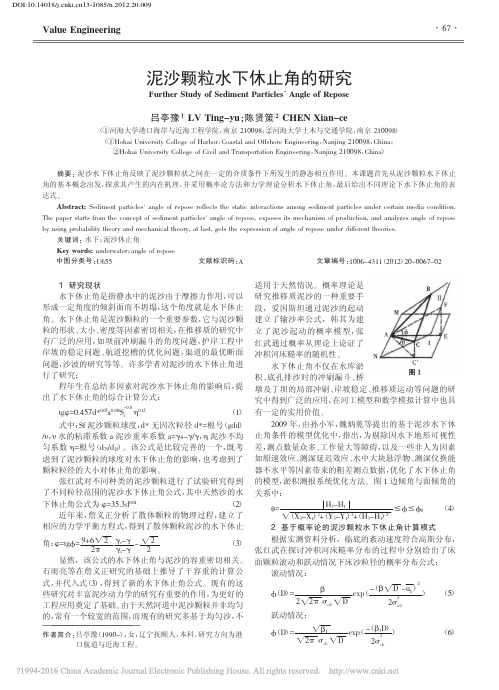
适用于天然情况。概率理论是
研究推移质泥沙的一种重要手
段,爱因斯坦通过泥沙的起动
建立了输沙率公式,韩其为建
立 了 泥 沙 起 动 的 概 率 模 型 ,张
红武通过概率从理论上论证了
冲积河床糙率的随机性。
水下休止角不仅在水库淤
张红武在探讨冲积河床糙率分布的过程中分别给出了床
面颗粒滚动和跃动情况下床沙粒径的概率分布公式:
滚动情况:
长江口南支南港的北槽枯季水体中混合_层化与潮汐应变_李霞(1)
象? 若存在,潮汐应变对其混合和层化的影响又如 何呢?
本文的目的就是定量分析长江口南支南港北 槽枯季水体中垂向混合和层化的潮周期变化以及 潮汐应变对它们的影响。
1 现场观测资料 2010年1月,水利部长江水利委员会长江口水
“潮汐应变"的概念已被应用到诸多河口物理 学的研究中。例如:美国Hudson River estuary[4], 英国Liverpool Bay [5],英国Rhine ROFI [6],美国San Francisco Bay[7],美国York River estuary[8],中国黄 河口[9]。国内,时钟等[10]在河口海岸海物理学国际 会议综述中介绍潮汐应变的概念;刘浩等[11]通过 泉州湾潮流、盐度和温度在大、小潮周期的观测 资料分析及定量计算,发现潮汐应变使水体的垂 向层化在落潮末期最强,而垂向混合最强在涨潮 末期。
suspended sediment concentration at three hydrological gauging stations CS1, CSW and CS8, within the curved navigational channel of the north passage of the south branch/south channel of the Changjiang River estuary, on spring, moderate and neap tides, on 1 to 10 January 2010. Those data display the spring/neap and flood/ebb tidal variability in the vertical stratification caused by salinity and suspended sediment concentration.To quantitatively evaluate the potential of vertical mixing within the curved channel, we estimate the gradient Richardson number (Ri) using the density of water after taking suspended sediment concentration into account. Ri at stations CS1 and CSW can be in the order of 101 ~ 102 at the turning of the tide. The strongest mixing with the order of 10-2 ~ 10-1 occurs at the maximum flood and ebb tides. Ri at station CS8 is between 0.25 and 5 at the flood tide and of the order of 10-2 at the ebb tide. At the three hydrological gauging stations, stratification appears to be stronger at the flood tide than at the ebb tide. Stronger stratification is present on the spring tide, while stratification lasts longer on the neap tide.Following Simpson, we estimate the rate of change in the potential energy of the water column within the curved channel caused by tidal straining, estuarine circulation, and tidal stirring. Tidal straining is present at the
英汉海洋科学名词
abiological removal 非生物转移abiotic zone 无生命带abrasion platform 海蚀台地absolute salinity 绝对盐度abundance 丰度abyssal circulation 深渊环流abyssal clay 深海粘土abyssal fauna 深渊动物abyssal hill 深海丘陵abyssal plain 深海平原abyssal zone 深渊带abyssopelagic organism 大洋深渊水层生物abyssopelagic plankton 深渊浮游生物abyssopelagic zone 深渊层accessory mark 副轮accretionary prism 增生楔accumulation 堆积作用acoustic remote sensing 声遥感acoustical oceanography 声学海洋学active continental margin 主动大陆边缘aerial remote sensing observation 航空遥感观测African Plate 非洲板块afternoon effect 午后效应Agassiz trawl 阿氏拖网age composition 年龄组成aggregated distribution 集聚分布ahermatypic coral 非造礁珊瑚air gun 气枪air lifting 气举air-born substances 气源物质airborne infrared radiometer 机载红外辐射计air-sea boundary process 海-气边界过程air-sea interaction 海-气相互作用air-sea interface 海-气界面air-tight 气密albedo of sea 海洋反照率"algal chemistry, phycochemistry " 藻类化学algal reef 藻礁alkalinity 碱度allochthonous population 外来种群allopatry 异域分布"alternating current, rectilinear current " 往复流ambient sea noise 海洋环境噪声amphi-boreal distribution 北方两洋分布amphidromic point 无潮点"amphidromic system, amphidrome " 旋转潮波系统amphi-Pacific distribution 太平洋两岸分布anadromic fish 溯河鱼anaerobic zone 厌氧带anaerobiosis 厌氧生活analytical chemistry of sea water 海水分析化学"anchor ice, ground ice " 锚冰anchorage area 锚泊地anchored structure 锚泊结构anomalous sea level 异常水位anoxic basin 缺氧海盆anoxic event 缺氧事件anoxic water 缺氧水"Antarctic Bottom Water, AABW " 南极底层水Antarctic Circumpolar Current 南极绕极流Antarctic Circumpolar Water Mass 南极绕极水团Antarctic Plate 南极洲板块anthropogenic hydrocarbon 人源烃anthropogenic input 人源输入antifouling 防污着aphotic zone 无光带"apparent oxygen utilization, AOU " 表观耗氧量aquaculture 水产养殖aquaculture 水产栽培aquafarm 水产养殖场aquanaut work 潜水作业aquaranch 水中牧场aquatic community 水生群落aquatic ecosystem 水生生态系archipelago 群岛Arctic Ocean 北冰洋"Arctic Water, North Polar Water " 北极水arc-trench-basin system 沟弧盆系armor block 护面块体armored diving 铠装潜水artificial island 人工岛artificial sea water 人工海水aseismic ridge 无震海岭assemblage 组合assimilation efficiency 同化效率assimilation number 同化数association 群聚astronomical tide 天文潮"Atlantic Equatorial Undercurrent, Lomonosov Current " 大西洋赤道潜流Atlantic Ocean 大西洋Atlantic-type coastline 大西洋型岸线Atlantic-type continental margin 大西洋型大陆边缘atmospheric input 大气输入atmospheric sea salt 大气海盐atmospheric transport 大气输送atoll 环礁auricularia larva 耳状幼体Australia-Antarctic Rise 澳大利亚-南极海隆autecology 个体生态学authigenic sediment 自生沉积autoinhibitory substance 自体抑制物质autotroph 自养生物auxotroph 营养缺陷生物average heavy swell 中狂涌average height of the heighest one-tenth wave 1/10 [大波平均]波高average height of the heighest one-third wave 1/3 [大波平均]波高average moderate swell 中中涌axially symmetric marine gravimeter 轴对称式海洋重力仪azimuth correction 方位改正back-arc 弧后back-arc basin 弧后盆地back-arc spreading 弧后扩张backshore 后滨bacterial film 细菌膜bacterial slime 细菌粘膜bacterioneuston 漂游细菌barbor boat 港作船baroclinic ocean 斜压海洋barophilic bacteria 喜压细菌barotropic ocean 正压海洋barrier 沙坝barrier island 沙坝岛barrier reef 堡礁baseline study 基线研究batch culture 一次性培养bathyal fauna 深海动物bathyal zone 深海带bathymetry 水深测量bathypelagic organism 大洋深层生物bathypelagic plankton 深层浮游生物bathypelagic zone 深层beach 海滩beach berm 滩肩beach cusp 滩角beach cycle 海滩旋回beach face 滩面beach nourishment 人工育滩beach profile 海滩剖面beach ridge 滩脊beach rock 海滩岩beam trawl 桁拖网bench 岩滩Benioff zone 贝尼奥夫带benthic community 底栖生物群落benthic division 海底区benthic-pelagic coupling 海底-水层耦合benthology 底栖生物学benthos 底栖生物berth 泊位bioadhesion 生物粘着bioassay 生物测试"biochemical oxygen demand, BOD " 生化需氧量biodegradation 生物降解biodeterioration 生物污染bioerosion 生物侵蚀biofacy 生物相biofouling 生物污着biogenic sediment 生物沉积biogenous hydrocarbon 生源烃biogenous silica 生源硅石biological detritus 生物碎屑biological input 生物输入biological noise 生物噪声biological oceanography 生物海洋学biological purification 生物净化biological removal 生物转移biological scavenging 生物清除bioluminescence 生物发光biomass 生物量bionics 仿生学biosphere 生物圈biota 生物区系biotope 生活小区bioturbation 生物扰动biozone 生物带bipinnaria larva 羽腕幼体bipolarity 两极同源bird-foot delta 鸟足[形]三角洲Bohai Coastal Current 渤海沿岸流Bohai Sea 渤海boomerang sediment corer 自返式沉积物取芯器borate alkalinity 硼酸[盐]碱度"borer, boring organism " 钻孔生物bottom current 底层流bottom friction layer 底摩擦层bottom grab 表层取样器bottom reflection 海底声反射bottom reverberation 海底混响bottom scattering 海底散射bottom water 底层水bottom wave 底波bottom-supported platform 坐底式平台boundary flux 界面通量box corer 箱式取样器box model 箱式模型brackish water species 半咸水种brash ice 碎冰"breaker, surf " 碎波breakwater 防波堤brine 卤水"brown clay, red clay " 褐粘土bubble effect 气泡效应buoyant mat 浮力沉垫burrowing organism 穴居生物caballing [混合]增密caisson 沉箱calcareous ooze 钙质软泥"calcite compensation depth, CCD " 方解石补偿深度calcite dissolution index 方解石溶解指数calm sea 无浪capillary wave 毛细波carbon assimilation 碳同化作用carbon cycle 碳循环carbon dioxide system in sea water 海水二氧化碳系统carbonate alkalinity 碳酸[盐]碱度"carbonate critical depth, CCRD " 碳酸盐极限深度carbonate cycle 碳酸盐旋回carbonate system in sea water 海水碳酸盐系统carcinology 甲壳动物学carnivore 食肉动物catastrophe 灾变catch 渔获量catchability coefficient 可捕系数cathodic protection 阴极防护cellar connection 井口装置Central Indian Ridge 印度洋中脊central rift 中央裂谷central water 中央水chain of volcanoes 火山链"Changjiang Diluted Water, Changjiang River Plume " 长江冲淡水characteristic species 特征种chemical diagenesis 化学成岩作用chemical form 化学形态chemical oceanography 化学海洋学"chemical oxygen demand, COD " 化学需氧量chemical scavenging 化学清除chemical speciation 化学形态分析chemical speciation models 化学形态模型chemical species 化学形式chemical weathering 化学风化作用chemo-autotroph 化能自养生物chemostatic culture 恒化培养"chemotaxis, chemotaxy " 趋化性chemotrophy 化能营养"China Classification Society, ZC " 中国船级社chlorinity 氯度chlorinity ratio 氯度比值chlorosity 氯量chronostratigraphy 年代地层学ciguatoxic fish 西加毒鱼类circumpacific volcanic belt 环太平洋火山带clay 粘土"closed season, prohibited season " 禁渔期cnoidal wave 椭圆余弦波coast of emergence 上升海岸coast of submergence 下沉海岸"coastal current, littoral current " 沿岸流coastal dune 海岸沙丘coastal engineering 海岸工程coastal terrace 海岸阶地coastal water 沿岸水coastal zone 海岸带coastline 海岸线coastline effect 海岸效应coccolith ooze 颗石软泥cofferdam 围堰cold current 寒流cold eddy 冷涡cold water species 冷水种cold water sphere 冷水圈cold water tongue 冷水舌collision zone 碰撞带commensalism 共栖commensalism 偏利共生common species 习见种community 群落community ecology 群落生态学compensation current 补偿流compensation depth 补偿深度compliant structure 顺应式结构composite breakwater 混合式防波堤compound shoreline 复合滨线compound tide 复合潮conchology 贝类学"conductivity-temperature-depth system, CTD " 温盐深仪confused sea 暴涛confused swell 暴涌conservative constituents of sea water 海水保守成分constancy of composition of sea water 海水成分恒定性constituent day 分潮日constituent hour 分潮时constructive boundary 建设性板块边界consumer 消费者continental accretion 大陆增生continental drift 大陆漂移continental margin 大陆边缘continental rise 大陆隆continental shelf 大陆架continental shelf break 大陆架坡折continental slope 大陆坡continental terrace 大陆阶地"continuous cultivation, continuous culture " 连续培养continuous model 连续模型contour current 等深流contourite 等深流沉积[岩]contrast in water 水中对比度contrast transmission in water 水中对比度传输controlled ecosystem experiment 控制生态系实验convective mixing 对流混合conventional diving 常规潜水convergent boundary 会聚边界conversion efficiency 转换效率"copepodite, copepodid larva " 桡足幼体coprophagy 食粪动物coral reef 珊瑚礁coral reef coast 珊湖礁海岸corrosion in sea water 海水腐蚀cosmogenous sediment 宇宙沉积cosmopolitan 世界[广布]种cotidal chart 同潮图countercurrent 逆流crane barge 起重船critical depth 临界深度crop 收获cross-coupling effect 交叉耦合效应current meter 海流计current pattern 流型cuspate bar 尖角坝cuspate delta 尖[形]三角洲cyphonautes larva 苔藓虫幼体cypris larva 腺介幼体Dalmatian coastline 达尔马提亚岸线datum of chart 海图基准面day-night observation 连续观测deck unit 甲板装置deep current 深层流"deep scattering layer, DSL " 深海散射层deep sea fan 深海扇deep sea propagation 深海传播deep sea sand 深海砂deep sea sediment 深海沉积deep sea sound channel 深海声道deep water 深层水deep water wave 深水波delta 三角洲demersal fish 底层鱼类density current 密度流density current 异重流density-dependent mortality 密度制约死亡率deposit feeder 食底泥动物descriptive oceanography 描述海洋学destructive boundary 破坏性板块边界detached breakwater 岛式防波堤detached wharf 岛式码头detritus feeder 食碎屑动物diagonal wave 斜向浪diatom ooze 硅藻软泥"dicycle, dicycly " 双周期"diel vertical migration, diurnal vertical migration " 昼夜垂直移动dilution cycle 稀释旋回directional wave spectrum 方向波谱dissolution cycle 溶解旋回"dissolved inorganic carbon, DIC " 溶解无机碳"dissolved organic carbon, DOC " 溶解有机碳"dissolved organic matter, DOM " 溶解有机物"dissolved organic nitrogen, DON " 溶解有机氮"dissolved organic phosphorus, DOP " 溶解有机磷dissolved oxygen 溶解氧disturbing acceleration 干扰加速度diurnal inequality 日不等[现象]diurnal tide 全日潮diver 潜水员divergent boundary 离散边界diversity 多样性diving suit 潜水服dock 船坞dominant species 优势种"Donghai Coastal Current, East China Sea Coastal Current " 东海沿岸流"Donghai Sea, East China Sea " 东海Doppler current meter 多普勒海流计double diffusion 双扩散double ebb 双低潮double flood 双高潮downwelling 下降流dredge 底栖生物刮底网dredger 挖泥船dredging engineering 疏浚工程drift current 漂流drift ice 流冰drifting buoy 漂流浮标drill conductor 隔水套管drilling vessel 钻探船dry diving 干式潜水duration-limited spectrum 有限风时谱dynamic method 动力方法dynamic positioning 动力定位dynamical oceanography 动力海洋学East African Rift Zone 东非裂谷带East Pacific Rise 东太平洋海隆"ebb, ebb tide " 落潮echinopluteus larva 海胆幼体echo ranging 回声测距echosounder 测深仪ecological barrier 生态障碍ecosystem 生态系edge wave 边缘波efflux 输出通量Ekman depth 埃克曼深度Ekman layer 埃克曼层Ekman pumping 埃克曼抽吸Ekman spiral 埃克曼螺旋Ekman transport 埃克曼输送El Nino ( 西) 厄尔尼诺electrodialysis 电渗析electromagnetic vibration exciter 电磁振荡震源elliptical trochoidal wave 椭圆余摆线波embayed coast 港湾海岸endemic population 地方种群endemic species 地方种endolithion 石内生物endopelos 泥内生物endopsammon 沙内生物energy flow 能流"engineering oceanology, engineering oceanography " 海洋工程水文enhancement 增殖entrainment 卷吸environmental load 环境荷载Eotvos effect 厄特沃什效应ephyra larva 碟状幼体epibenthic sledge 底表撬网epifauna 底表动物epilithion 石面生物epipelagic organism 大洋上层生物epipelagic zone 上层epipelos 泥面生物epiphyte 附生植物epiplankton 上层浮游生物epipsammon 沙面生物Equatorial Countercurrent 赤道逆流Equatorial Current 赤道流"Equatorial Undercurrent, EUC " 赤道潜流equilibrium profile 平衡剖面equilibrium tide 平衡潮equinoctial tide 分点潮equivalent duration 等效风时equivalent fetch 等效风区estuarine chemistry 河口化学estuary 河口湾estuary improvement 河口治理euphotic layer 真光层Eurasian Plate 欧亚板块eurybaric organism 广压性生物eurybathic organism 广深性生物euryhaline species 广盐种euryphagous animal 广食性动物"eurythermal species, eurythermic species " 广温种eustasy 全球性海面升降eutrophic water 富营养水eutrophication 富营养化[作用]euxinic environment 静海环境event deposit 事件沉积exclusive economic zone 专属经济区exogenous organic matter 外源有机物"expendable bathythermograph, XBT " 投弃式温深计exploitative engineering of offshore petroleum/gas reservoir 海上油气开发工程exploratory engineering of offshore petroleum/gas reservoir 海上油气勘探explosive energy source 炸药震源exposed waters 开阔海域failure probability 破坏概率fan delta 扇[形]三角洲fast ice 固定冰fatigue break 疲劳断裂fault coast 断层海岸feather angle 羽角feathering 羽状移动fecal pellet 粪粒fecundity 生殖力feeding migration 索饵洄游fertility 肥力fetch 风区fetch-limited spectrum 有限风区谱fictitious body 假想天体"filter feeder, suspension feeder " 滤食性动物finestructure 细结构fiord 峡湾fish finder 鱼探仪fish resources 鱼类资源fisheries oceanography 渔业海洋学fishery management 渔业管理fishery resources 渔业资源fishing effort 捕捞能力fishing intensity 捕捞强度fishing mortality coefficient 渔捞死亡系数fishing season 渔期fixed oceanographic station 定点观测站fixed structure 固定式结构flare boom 火炬臂"flat coast, low coast " 低平海岸floating breakwater 浮式防波堤floating hose 浮式软管floating structure 浮式结构floating-type wharf 浮式码头floe ice 浮冰"flood, flood tide " 涨潮food chain 食物链food organism 饵料生物food pyramid 食物金字塔food web 食物网foraminiferal ooze 有孔虫软泥fore-arc 弧前fore-arc basin 弧前盆地forerunner 先行涌foreshore 前滨fouling organism 污着生物foundation bed 基床foundation capability 地基承载能力fracture zone 破裂带freshwater plume 淡水舌frictional depth 摩擦深度"fringing reef, shore reef " 岸礁fully developed sea 充分成长风浪gas exploder 气爆震源gateway 峡口general circulation 总环流geographical barrier 地理障碍geological oceanography 地质海洋学"geomagnetic electrokinetograph, GEK " 电磁海流计geostrophic current 地转流geotechnical test 土工试验glacial effect 冰川效应globigerina ooze 抱球虫软泥Gondwana 冈瓦纳古陆gravitational tide 引力潮gravity corer 重力取芯器gravity platform 重力式平台gravity wave 重力波gravity-type structure 重力式结构grazing angle 掠射角groin 丁坝gross primary production 毛初级生产量growth efficiency 生长效率growth overfishing 生长型捕捞过度Gulf Stream 湾流"gulf, bay " 海湾guyed-tower platform 拉索塔平台guyot 平顶海山gyre 流涡habitat 生境"hadal fauna, ultra-abyssal fauna " 超深渊动物"hadal zone, ultra-abyssal zone " 超深渊带half-tide level 半潮面halmyrolysis 海解作用halobiont 盐生生物halocline 盐跃层halophile organism 适盐生物harbor accommodation 港口设施harbor entrance 口门harbor hinterland 港口腹地harbor land area 港口陆域harbor siltation 港口淤积harbour basin 港池harbour site 港址Hardy continuous plankton recorder 哈迪浮游生物记录器harmonic analysis of tide 潮汐调和分析harmonic constant of tide 潮汐调和常数hatchability 孵化率"headland, cape " 岬角heave 垂荡"hekistoplankton, ultraplankton " 超微型浮游生物helium-nitrogen-oxygen saturation diving 氦-氮-氧饱和潜水helium-oxygen diving 氦-氧潜水hemipelagic deposit 半远洋沉积"herbivore, grazer " 食植动物hermatypic coral 造礁珊瑚heterogeneity 异质性heterotroph 异养生物high energy marine environment 海洋高能环境high sea 狂浪"high water, HW " 高潮"highest astronomical tide, HAT " 最高天文潮位holophytic nutrition 全植型营养holoplankton 终生浮游生物homogeneity 同质性homogeneous layer 均匀层horizontal distribution 平面分布hot spot 热点hot spring 海底热泉"Huanghai Coastal Current, Yellow Sea Coastal Current " 黄海沿岸流"Huanghai Cold Water Mass, Yellow Sea Cold Water Mass " 黄海冷水团"Huanghai Sea, Yellow Sea " 黄海"Huanghai Warm Current, Yellow Sea Warm Current " 黄海暖流humification 腐殖化[作用]hummocked ice 堆积冰hydraulic model test 水力模型试验hydraulic piston corer 液压活塞取芯器hydrobiology 水生生物学hydrobiont 水生生物hydrodynamic noise 流体动力噪声hydrothermal circulation 热液循环hydrothermal process 热液过程ice cover 冰盖ice edge 冰缘线ice field 冰原ice period 冰期ice rind 冰壳ice shelf 冰架ice thickness 冰厚iceberg 冰山ichthyology 鱼类学implosive source 聚爆式震源in situ density 现场密度in situ measurement 现场测定in situ salinometer 现场盐度计in situ specific volume 现场比容in situ temperature 现场温度incident wave 入射波"incubation, hatching " 孵化Indian Ocean 印度洋Indian Plate 印度洋板块indicator species 指示种infauna 底内动物influx 输入通量inshore 内滨instanteneous mortality rate 瞬间死亡率interface exchange process 界面交换过程intermediate water 中层水internal tide 内潮internal wave 内波interstitial fauna 间隙动物"interstitial water, pore water " 间隙水intertidal zone 潮间带"Intertropical Convergence Zone, Equatorial " 赤道辐合带intraplate volcanism 板内火山活动inversion layer 逆置层in-vivo fluorescence technique 活体荧光技术ion-exchange membrane 离子交换膜irregular wave 不规则波island 岛island arc 岛弧island shelf 岛架island slope 岛坡isohaline 等盐线isotherm 等温线jacket pile-driven platform 导管架桩基平台jack-up platform 自升式平台jetty 突堤jetty 导堤juvenile 幼年个体Kelvin wave 开尔文波key species 关键种knuckle joint 万向接头Knudsen's burette 克努森滴定管Knudsen's pipette 克努森移液管Knudsen's tables 克努森表Kuroshio 黑潮lag effect 滞后效应lagoon 湖lamellibranchia larva 瓣鳃类幼体land and sea breezes 海陆风land fabrication 陆上预制land-origin ice 陆源冰larva 幼体lateral reflection 侧反射launching 下水Laurasia 劳亚古陆law of the sea 海洋法lead lane 冰间水道level bottom community 平底生物群落level ice 平整冰life support system 生命支持系统light acclimation 光驯化light adaptation 光适性light and dark bottle technique 黑白瓶法light boat 灯船light house 灯塔light saturation 光饱和Lloyd's Register of Shipping 劳埃德船级社long heavy swell 长狂涌long low swell 长轻涌long moderate swell 长中涌long-crested wave 长峰波Longhurst-Hardy plankton recorder 朗-哈浮游生物记录器longshore current 顺岸流"longshore drift, littoral drift " 沿岸泥沙流"low water, LW " 低潮"lowest astronomical tide, LAT " 最低天文潮位luminous organism 发光生物lunar tide 太阴潮lunar tide interval 太阴潮间隙lysis 溶菌lysocline 溶跃层macrobenthos 大型底栖生物macrofauna 大型动物macroplankton 大型浮游生物magnetic lineation 磁条带magnetic quiet zone 磁场平静带main thermocline 主[温]跃层major constituents of sea water 海水主要成分malacology 软体动物学"manganese nodule, ferromanganese nodule " 锰结核mangrove coast 红树林海岸mangrove swamp 红树林沼泽manifold system 管汇系统mantle bulge 地幔隆起mantle convection 地幔对流mantle plume 地幔柱marginal basin 边缘盆地marginal sea 边缘海marginal-type wharf 顺岸码头mariculture 海产养殖mariculture 海产栽培marine accident 海损事故marine acoustics 海洋声学marine aerosol 海洋气溶胶marine bio-acoustics 海洋生物声学marine biochemical resource 海洋生化资源marine biochemistry 海洋生物化学marine biogeochemistry 海洋生物地球化学marine biological noise 海洋生物噪声marine biology 海洋生物学marine chemical resource 海洋化学资源marine chemistry 海洋化学"marine climate, ocean climate " 海洋气候marine climatology 海洋气候学marine contamination 海洋玷污marine corrosion 海洋腐蚀marine detritus 海洋碎屑marine ecology 海洋生态学marine ecosystem 海洋生态系marine element geochemistry 海洋元素地球化学marine engineering geology 海洋工程地质marine environment 海洋环境marine environmental assessment 海洋环境评价marine environmental capacity 海洋环境容量marine environmental chemistry 海洋环境化学"marine environmental forecasting, marine " 海洋环境预报marine environmental monitoring 海洋环境监测marine environmental protection 海洋环境保护marine environmental quality 海洋环境质量marine environmental sciences 海洋环境科学marine erosion 海蚀作用marine geochemistry 海洋地球化学marine geology 海洋地质学marine geomagnetic anomaly 海洋地磁异常marine geomagnetic survey 海洋地磁调查marine geomorphology 海洋地貌学marine geophysical survey 海洋地球物理调查marine geophysics 海洋地球物理学marine gravimeter 海洋重力仪marine gravity anomaly 海洋重力异常marine gravity survey 海洋重力调查marine heat flow survey 海洋地热流调查marine humus 海洋腐殖质"marine hydrography, marine hydrology " 海洋水文学marine installation 海上安装沉放marine isotope chemistry 海洋同位素化学marine meteorology 海洋气象学marine microorganism 海洋微生物marine natural hydrocarbon 海洋天然烃marine natural product 海洋天然产物marine natural product chemistry 海洋天然产物化学marine organic chemistry 海洋有机化学marine organic geochemistry 海洋有机地球化学marine pharmacognosy 海洋生药学marine photochemistry 海洋光化学marine physical chemistry 海洋物理化学marine physics 海洋物理学marine policy 海洋政策marine pollutants 海洋污染物marine pollution 海洋污染marine pressure hydrophone 海洋压力水听器marine reflection seismic survey 海洋反射地震调查marine refraction seismic survey 海洋折射地震调查marine resource chemistry 海洋资源化学marine resources 海洋资源marine salvage 海难救助"marine sciences, ocean sciences " 海洋科学marine sedimentology 海洋沉积学marine seismic profiler 海洋地震剖面仪marine seismic streamer 海洋地震漂浮电缆marine seismic survey 海洋地震调查marine seismograph 海洋地震仪marine stratigraphy 海洋地层学marine technology 海洋技术marine towage 海上拖运marine wide-angle reflection seismic survey 海洋广角反射地震调查maritime air mass 海洋气团marking 标记marsh organism 沼泽生物mass balance 质量平衡mass budget 质量收支mass transfer 质量转移"mean sea level, MSL " 平均海平面"mechanical bathythermograph, MBT " 机械式温深计medical security for diving 潜水医务保障megafauna 巨型动物megalopa larva 大眼幼体megaplankton 巨型浮游生物meiobenthos 小型底栖生物meiofauna 小型动物"meroplankton, transitory plankton " 阶段性浮游生物mesocosm 中型实验生态系mesopelagic fish 中层鱼类mesopelagic organism 大洋中层生物mesopelagic zone 中层mesoplankton 中型浮游生物mesopsammon 沙间生物mesoscale eddy 中尺度涡meteorological tide 气象潮microbenthos 微型底栖生物microbivore 食微生物者microcolony 小菌落microcontinent 微大陆microcosm 小型实验生态系microdistribution 微分布microecosystem 微生态系microfauna 微型动物microfouling 微生物污着microhabitat 微生境micronutrients 微量营养物microplankton 小型浮游生物microstructure 微结构Mid-Atlantic Ridge 大西洋中脊mid-ocean ridge 洋中脊mid-ocean ridge basalt 洋中脊玄武岩midwater trawl 中层拖网migratory fish 洄游鱼类minimum duration 最小风时minimum fetch 最小风区minor elements of sea water 海水微量元素mirage 蜃景mixed layer sound channel 混合层声道"mixed layer, mixing layer " 混合层mixed tide 混合潮mixotroph 混合营养生物mobile platform 移动式平台moderate sea 中浪module 模块"monocycle, monocycly " 单周期monophagy 单食性monsoon current 季风海流moored data buoy 锚定资料浮标mooring facilities 系泊设施mooring force 系泊力mortality 死亡率mound-type breakwater 斜坡式防波堤mud 泥muddy coast 泥质海岸multibeam echosounder 多波束测深仪multi-point mooring 多点系泊multistage flash distillation 多级闪急蒸馏multistage separator 多级分离器mysis larva 糠虾期幼体N/P ratio 氮磷比[值]"Nanhai Coastal Current, South China Sea Coastal Current " 南海沿岸流"Nanhai Sea, South China Sea " 南海"Nanhai Warm Current, South China Sea Warm Current " 南海暖流nannoplankton 微型浮游生物nauplius larva 无节幼体navigation channel 航道navigation equipment 导航设备neap tide 小潮nearshore zone 近滨带nectochaeta larva 疣足幼体nektobenthos 游泳底栖生物nekton 游泳生物nepheloid 雾状层neritic organism 近海生物neritic sediment 浅海沉积neritic zone 浅海带neritic zone 近海区net plankton 网采浮游生物net primary production 净初级生产量net primary productivity 净初级生产力neurotoxin 神经毒素niche 生态位Ninety East Ridge 东经90度洋中脊Niskin water sampler 尼斯金采水器nitrogen cycle 氮循环nitrogen-oxygen diving 氮-氧潜水no swell 无涌non-conservative constituents of sea water 海水非保守成分nonharmonic constant of tide 潮汐非调和常数non-saturation diving 非饱和潜水Norpac net 北太浮游生物网North American Plate 北美洲板块"North Atlantic Deep Water, NADW " 北大西洋深层水not fully developed sea 未充分成长风浪nursing ground 育幼场nutrient depletion 营养[盐]耗竭nutrients in sea water 海水营养盐obduction plate 仰冲板块obduction zone 仰冲带oblique haul 斜拖observation platform 观测平台ocean 洋ocean basin 洋盆ocean bottom seismograph 海底地震仪ocean circulation 大洋环流ocean color scanner 海色扫描仪ocean current 海流ocean current energy 海流能ocean energy conversion 海洋能转换ocean energy resources 海洋能源ocean engineering 海洋工程ocean exploitation 海洋开发ocean management 海洋管理ocean observation technology 海洋观测技术"ocean optics, marine optics " 海洋光学ocean power generation 海洋能发电ocean salinity energy 海洋盐差能ocean thermal energy 海洋温差能ocean wave 海浪ocean wave spectrum 海浪谱ocean-atmosphere heat exchange 海气热交换oceanic crust 洋壳oceanic front 海洋锋oceanic optical remote sensing 海洋光学遥感oceanic plate 大洋板块oceanic sound scatterer 海洋声散射体oceanic tholeiite 大洋拉斑玄武岩oceanic troposphere 大洋对流层oceanic turbulence 海洋湍流oceanic zone 大洋区oceanization 大洋化作用"oceanographic survey, oceanographic investigation " 海洋调查"oceanography, oceanology " 海洋学offshore 外滨offshore bar 滨外坝offshore engineering 近海工程offshore loading and unloading system 海上装卸油系统offshore oil-gas flowline 海上输油气管线offshore platform 近海平台offshore storage unit 海上贮油装置oil fence [围]油栅oil-gas-water treating system 油气水处理系统oligohaline species 寡盐种oligostenohaline species 低狭盐种oligotaxic ocean 少种型大洋oligotrophic water 贫营养水omnivore 杂食动物ooze 软泥ophiopluteus larva 长腕幼体opportunistic species 机会种optimum catch 最适渔获量organic coating layer 有机覆盖层overfishing 捕捞过度overlying water 上覆水overpopulation 种群过密overtide 倍潮overwintering 越冬oxide film 氧化膜oxygen maximum layer 氧最大层oxygen minimum layer 氧最小层oxygen partial pressure 氧分压Oyashio 亲潮oyster reef 牡蛎礁"Pacific Equatorial Undercurrent, Cromwell Current " 太平洋赤道潜流Pacific Ocean 太平洋Pacific Plate 太平洋板块Pacific-type coastline 太平洋型岸线Pacific-type continental margin 太平洋型大陆边缘pack ice 浮冰群paleoceanography 古海洋学paleocurrent 古海流paleodepth 古深度paleomagnetic stratigraphy 古地磁地层学paleoproductivity 古生产力paleosalinity 古盐度Pangaea 泛大陆Panthalassa 泛大洋parallel dike 顺坝parasitism 寄生"particulate inorganic carbon, PIC " 颗粒无机碳particulate matter in sea water 海水颗粒物"particulate organic carbon, POC " 颗粒有机碳"particulate organic matter, POM " 颗粒有机物"particulate organic nitrogen, PON " 颗粒有机氮"particulate organic phosphorus, POP " 颗粒有机磷passive continental margin 被动大陆边缘patch reef 点礁patchiness 斑块分布pediveliger larva 具足面盘幼体pelagic deposit 远洋沉积pelagic division 水层区pelagic egg 浮性卵pelagic fish 上层鱼类pelagic organism 水层生物pelagic organism 大洋生物pelagic phase 浮性生活期peleotemperature 古温度peninsula 半岛periphyton 周丛生物permanent thermocline 永久性温跃层phaeophytin 脱镁叶绿素phosphorus cycle 磷循环photo-autotroph 光能自养生物photobacteria 发光细菌photochemical transformation 光化学转化photophilous organism 适光生物photosynthetic activity 光合活性"phototaxis, phototaxy " 趋光性phycology 藻类学phyllosoma larva 叶状幼体physical oceanography 物理海洋学phytoplankton 浮游植物pile group 群桩pile-driving barge 打桩船pilidium larva 帽状幼体pipe-laying ship 敷管船piston corer 活塞取芯器pitch 纵摇planktobacteria 浮游细菌plankton 浮游生物plankton equivalent 浮游生物当量plankton indicator 浮游生物指示器plankton net 浮游生物网plankton pump 浮游生物泵plankton recorder 浮游生物记录器"planktonology, planktology " 浮游生物学planula larva 浮浪幼体plate 板块plate boundary 板块边界plate collision 板块碰撞plate convergence 板块会聚plate tectonics 板块构造学pleuston 漂浮生物plunging breaker 卷碎波poikilotherm 变温动物Poincare wave 庞加莱波polar ice 极地冰pollutant 污染物polymetal crust 多金属结壳polymorphism 多态现象polyphagy 复食性polystenohaline species 高狭盐种polytaxic ocean 多种型大洋population 种群population dynamics 种群动态population ecology 种群生态学porcellana larva 磁蟹幼体porosity 孔隙度"port engineering, harbor engineering " 港口工程post-larva 稚期practical salinity 实用盐度practical salinity scale 1978 1978 实用盐标precipitous sea 怒涛predation 捕食[现象]predator 捕食者preformed nutrients 原存营养盐pressure-relief tank 减压舱pressurized compartment 加压舱prey 猎物primary production 初级生产量primary productivity 初级生产力producer 生产者。
海滩平衡剖面研究述评
海滩平衡剖面研究述评◎ 吴瀚彬 中国海洋大学摘 要:平衡剖面是指在波浪、潮流等动力要素和泥沙特性不变的条件下,海滩剖面会逐渐趋于平衡。
平衡剖面理论对海岸工程的建设,海滩养护的设计等具有重要的指导意义。
回顾了国内外对海滩平衡剖面理论的研究进展,从平衡剖面的经验形态函数、水沙运动机制和平衡时间尺度三个方面,系统概述了该领域的研究现状与发展趋势,归纳了现有研究的局限性,提出了相应的研究展望。
关键词:平衡剖面;动力机制;平衡尺度1.引言近岸区域一般是指从海岸向海延伸大约10~20米以浅的海域,是海洋和大陆交汇的敏感区域,涉及复杂的地形与驱动泥沙的浪潮流等动力要素的非线性耦合,是多学科交叉研究的热点与前沿领域。
海滩平衡剖面在海洋地质学[1]中的定义为:近岸海区从水深等于盛行波1/2波长的深处,至暴风浪可达到的岸滩最高点之间,由粒径相同和比重相同的泥沙构成坡度均匀的海底,在波浪的作用下,其侵蚀和堆积处于相对平衡状态的海底剖面。
平衡剖面表征波浪、波生流等动力因素与地貌形态和泥沙特性在长时间尺度上的非线性耦合作用。
研究平衡剖面理论有助于提高养滩工程的效率,减少养滩工程的成本,尤其是对于补沙位置以及补沙周期的选取。
此外,对于研究海平面上升下的岸滩侵蚀也具有十分重要的意义。
本文在回顾国内外平衡剖面理论研究的基础上,从平衡剖面的经验形态和动力机制两个方面概述了该领域的研究现状以及发展趋势,总结并提出已有研究存在的不足及今后需要进一步研究的课题。
2.平衡剖面的经验形态近岸地貌形态总体上表现为上凹形,坡度从岸线向海方向递减,大量的研究致力于使用基于统计学规律的经验性数学表达式描述剖面的几何形态。
此类经验模型根据公式的复杂程度可以分为单调式、分段式以及复合式。
单调式的平衡剖面形态以幂函数为代表,用以表征水深与离岸距离之间的关系。
此类函数的模式(h=A x m)由Br uu n率先提出,之后由Dean加以完善,因此也被称为Br uu n-D e a n模型。
泥质潮滩水盐运移过程电阻率探针高精度监测效果分析

第54卷 第4期 2024年4月中国海洋大学学报P E R I O D I C A L O F O C E A N U N I V E R S I T Y O F C H I N A54(4):106~115A pr .,2024泥质潮滩水盐运移过程电阻率探针高精度监测效果分析❋李明波1,2,张宇丰3,郭秀军3,4❋❋,吴 振1,2,武 斌1,2,马 健1,2,聂佩孝1,2(1.山东省第四地质矿产勘查院,山东潍坊261021;2.山东省地矿局海岸带地质环境保护重点实验室,山东潍坊261021;3.中国海洋大学环境科学与工程学院,山东青岛266100;4.山东省海洋环境地质工程重点实验室,山东青岛266100)摘 要: 本研究在莱州湾泥质潮滩开展测试,量化分析了环状电阻率探针监测沉积物电阻率与孔隙水盐度变化的能力,并使用该技术初步刻画了细粒沉积层中水盐运移过程㊂结果表明,环状电阻率探针监测结果可精细描述沉积物电阻率的分布及变化规律;基于监测结果换算的孔隙水盐度变化比与实际孔隙水盐度变化比存在ʃ10%的误差,环状电阻率探针具有粗略定量分析泥质潮滩水盐运移过程的能力;潮汐循环中泥质潮滩地下水水盐运移过程在涨潮时期,高盐度水体主要补给细粒沉积层的顶部与底部㊂高潮时期间,细粒沉积层顶部与底部的盐分逐步丧失,中部水体盐分累积速率加快㊂退潮时期,细粒沉积层盐分整体丧失,高盐度水体通过渗出面向外释放㊂关键词:环状电极电阻率探针;泥质海岸;水盐运移过程;监测效果;盐度变化比中图法分类号: P 345 文献标志码: A 文章编号: 1672-5174(2024)04-106-10D O I : 10.16441/j.c n k i .h d x b .20230008引用格式: 李明波,张宇丰,郭秀军,等.泥质潮滩水盐运移过程电阻率探针高精度监测效果分析[J ].中国海洋大学学报(自然科学版),2024,54(4):106-115.L i M i n g b o ,Z h a n g Y u f e n g ,G u o X i u j u n ,e t a l .H i g h -p r e c i s i o n m o n i t o r i n g e f f e c t a n a l y s i s o f r e s i s t i v i t y pr o b e i n t h e w a t e r a n d s a l t t r a n s p o r t p r o c e s s i n m u d d y t i d a l f l a t [J ].P e r i o d i c a l o f O c e a n U n i v e r s i t y of C h i n a ,2024,54(4):106-115. ❋ 基金项目:山东省第四地质矿产勘查院科技创新项目(K J 2106);山东省地矿局科技公关项目(K Y 202206);潍坊市财政基金项目(S D G P 370700202102000413);山东省地下水环境保护与修复工程技术研究中心(筹)开放基金项目(201703075-57)资助S u p p o r t e d b y t h e S c i e n c e a n d T e c h n o l o g y I n n o v a t i o n P r o j e c t o f N o .4E x p l o r a t i o n I n s t i t u t e o f G e o l o g ya n d M i n e r a l R e s o u r c e s o f S h a n -d o n g P r o v i n c e (K J 2106);t h e K e y S c i e n t i f i c a n d T e c h n o l o g i c a l R e s e a r c h P r o j e c t ,S h a n d o n g P r o v i n c i a l B u r e a u o f G e o l o g y &Mi n e r a l R e s o u r c e s (K Y 202206);t h e W e i f a n g F i n a n c i a l F u n d P r o j e c t (S D G P 370700202102000413);t h e O p e n F u n d P r o j e c t o f S h a n d o n g Pr o v -i n c e G r o u n d w a t e r E n v i r o n m e n t P r o t e c t i o n a n d R e s t o r a t i o n E n g i n e e r i n g T e c h n o l o g y Re s e a r c h C e n t e r (201703075-57)收稿日期:2023-01-10;修订日期:2023-03-04作者简介:李明波(1986 ),男,高级工程师,研究方向为区域地质调查与矿产勘查㊂E -m a i l :l i m i n g b o @s d d k s y.c o m ❋❋ 通信作者:郭秀军(1972 ),男,教授㊂E -m a i l :g u o j u n qd @o u c .e d u .c n 泥质海岸是世界重要的海岸类型之一,广泛分布于海湾及河流入海区域㊂当前泥质海岸的关注问题集中在滨海湿地土壤盐渍化以及滨海卤水资源可持续开发上㊂厘清泥质海岸表层细粒沉积层中水体与溶质的分布㊁迁移规律,是解决以上环境及资源问题的基础㊂泥质海岸地下水水文过程模型的建立始于21世纪初,至今仍在修改㊁完善㊂当前研究该问题的主要方法包括地球化学分析㊁数值模拟及原位地球物理调查㊂传统研究主要基于地下水常规离子分析㊁氢氧同位素测试等地球化学分析结果,确定泥质海岸多层含水层系统中水㊁盐的来源,以此为基础建立地下水与溶质的补给模型[1-2];随着算法优化,数值模拟与原位水文观测结合的方法开始用于泥质海岸多层含水层中流场㊁溶质分布及变化规律的研究[3-9]㊂马倩㊁常雅雯与郭雪倩将多层含水层系统中各地层视为均质,初步模拟分析了多层含水层系统中流场与溶质的分布演化过程,评价了弱透水层中天窗区对越流补给的影响,量化了海底地下水排泄通量[5-7]㊂X i n 等[8]与X i a o 等[9]模拟了受生物活动影响更为复杂的地下水循环过程㊂证明了生物通道能够显著促进表层沉积物中海水的循环速率;地球物理电学观测是一类新兴的地下水文过程观测方法,S u 等[10]应用此方法分析了潮汐对泥质海岸沉积物电性的影响,并划分了莱州湾滨海含水层系统中的海水入侵通道㊂F u 等[11]基于电阻率层析成像(E l e c -t r i c a l r e s i s i t i v i t y t o m o g r a p h y,E R T )监测结果,建立了泥质海岸多层滨海含水层系统中的水盐运移模型;张宇丰等[12]基于E R T 与水文参数监测结果,讨论了表层细粒沉积层的渗透性差异对海水-潜水卤水交换过程的影响,初步量化了潮汐循环中多层滨海含水层内发生的盐分通量㊂综上可知,当前已有研究更多关注泥质海岸多层滨海含水层系统,并以此建立大尺度的水盐运移模型㊂事实上,潮间带生卤㊁土壤盐渍化及生物活动的区域多集中在表层细粒沉积层中[9,13-15]㊂在蒸发与潮汐循环4期李明波,等:泥质潮滩水盐运移过程电阻率探针高精度监测效果分析作用下,潮间带细粒沉积层中孔隙水盐度维持在较高水平的动态平衡中,每年每平方千米的表层细粒沉积层可为地下卤水资源补给16万m 3大于10波美度的卤水[15]㊂活跃的生物活动产生的通道能够增大表层细粒沉积物的渗透性与异质性,显著加快海水-地下水的交换速率,不仅为潮间带生卤补给浅层卤水资源提供优先路径,还促进了基质中孔隙水与海水等其他水体间的溶质交换,改变基质中孔隙水盐度,影响土壤盐渍化进程[8-9,11-13]㊂准确㊁细致认识细粒沉积层中水盐运移规律是揭示潮滩生卤补给潜水卤水机制与通量的基础,可为滨海地下卤水资源以及生态环境管理提供理论支持,但目前未有研究能够精细描述潮汐循环中细粒沉积层中水盐的运移过程㊂为精细刻画以上过程,要求监测技术对地下介质变化的反应有较高灵敏度,同时具有较高的空间分辨能力㊂由于不同含盐量沉积物存在明显电性差异,电学监测可基于此物理前提对水盐运移过程进行刻画[16-18]㊂电阻率探针技术在垂直方向上具有较高的分辨能力,其还能避免E R T 监测随探测深度增加探测灵敏度下降的缺点㊂目前电阻率探针技术主要应用于海底水土界面划分[19]㊁海洋土蚀积过程监测[20-21]㊁海底浅层气迁移过程监测[22-23]以及土壤盐渍化监测[24],但目前尚未对电阻率探针监测泥质潮滩水盐运移过程的能力进行分析㊂本研究选取莱州湾南岸泥质潮滩为研究区开展工作,分析环状电阻率探针(R i n g e l e c t r o d e r e s i s t i v i t ypr o b e ,R E P )监测潮汐过程表层细粒沉积物中水盐运过程的灵敏度,评价依据孔隙水盐度变化比量化分析孔隙水盐分累积与释放过程的误差,并基于R E P 监测结果初步描述潮汐过程中泥质海岸表层细粒沉积层中的水盐运移过程㊂1 研究区概况研究区位于中国山东省莱州湾南岸的淤泥质海岸㊂该区域地形平缓,平均坡度小于千分之三(<3ɢ),宽阔的潮滩向莱州湾内延伸5~20k m ,平均水平水力梯度1.64%,地下潜水位高程约为-0.8m [25-26]㊂该区域地层自上而下可分为表层细粒沉积层㊁潜水卤水层㊁弱透水层及承压卤水层四层,分别为厚约4~5m 的粘质粉土层;厚约6~8m 的中细砂层;厚5~7m 的粘质粉土层;中砂层与细砂层[26-28]㊂图1 研究区位置㊁工作布设位置及地质钻孔柱状图F i g .1 L o c a t i o n ,w o r k i n g p o i n t a n d g e o l o g i c a l c o l u m n s o f s t u d y ar e a 研究区潮汐属于不规则半日潮,平均潮差约为0.9m ,平均涨潮时间382m i n ,平均落潮时间366m i n㊂莱州湾南岸属暖温带大陆性季风气候,年均降雨量和蒸发量分别为559.5和1936.7m m [26],蒸发作用强烈㊂莱州湾海域自上更新世以来经历了三次海侵与海退,在滨海含水层系统内形成了水平带状分布的三至五层卤水㊂位于顶部的潜水卤水T D S 值在50~140g /L 之间[26,29]㊂2 工作布设与方法2.1R E P 参数设置及电阻率计算方法本研究中使用的环状电极探针总长4m ,数据采集段长3.45m ,24个不锈钢电极环(C 1 C 24)等间距分布,电极极距a 为0.15m ,电极环半径b 为0.03m ,装置示意图与实物图见图2㊂电学测量选用W e n n e r 排列,数据采集时两个供电电极发射电流,形成电场,电701中 国 海 洋 大 学 学 报2024年场大小正相关于供电电极间的距离,环电极探针所测电阻率数据为电场范围内介质整体的电阻率,根据W e n n e r 排列测量原理,有效测量半径为1.5倍的极距,即0.225m ㊂测量仪器为G e o pe n 公司生产的E 60D N 分布式电图2 R E P 监测系统示意图(a )及R E P 探杆实物图(b)F i g .2 S c h e m a t i c d i a g r a m o f R E P m o n i t o r i n gs y s t e m (a )a n d R E P p h y s i c a l ph o t o (b )法仪及多电极智能电缆㊂使用12V 直流电源对测量仪器及主机供电㊂测量供电时长为1s ,电流大小为1A ㊂每次测量分别以C i 与C i +3为供电电极A ㊁B ,以C i +1与C i +2为测量电极M ㊁N (i 为测量次数)㊂测量时记录电位差ΔV i 与电流I i ,基于公式(1)可计算得到细粒沉积层不同深度位置的沉积物电阻率ρi[23]㊂ρi =π2b ΔV iI il n 4a +2πb 4a +πb-1㊂(1)2.2R E P 测量精度验证分别在淡水及海水环境下测试R E P 测量精度㊂使用自来水与自配高盐度水(盐度为30)分别模拟淡水环境与海水环境㊂淡水及海水电阻率分别为23.64与0.251Ω㊃m ㊂使用R E P 测量不同环境中介质电阻率,每类环境中重复试验3组,取三组试验的均值与介质电阻率实测值对比,分析R E P 装置自身的测量误差㊂图3显示了两个R E P (R 1与R 2)在淡水及海水环境中的测量误差㊂在淡水环境中,R E P 的测量误差区间在ʃ1%之内;在盐度较高的海水环境中,电极受极化影响程度升高,R E P 测量误差区间虽有增大但未超过ʃ3%,约1/2的数据点落在误差区间ʃ1%之内㊂因此R E P 基本能够满足在不同类型地下水环境中开展监测工作的测量精度要求㊂图3 不同环境中两个R E P (R 1与R 2)测量误差图F i g .3 E r r o r d i a gr a m o f t w o R E P m e a s u r e m e n t s (R 1&R 2)i n d i f f e r e n t e n v i r o n m e n t s 8014期李明波,等:泥质潮滩水盐运移过程电阻率探针高精度监测效果分析2.3R E P 原位布设及数据采集方法在距离G 1点80及110m 位置分别布设电阻率探针R 1和R 2,具体点位如图1所示㊂采用旋转贯入的方式将电阻率探针置入沉积物中㊂装置布设完成后需稳定1周再进行测量㊂在单个潮汐循环内的不同潮时(a ㊁b ㊁c 与d 时刻)开展测量工作(测量时刻见图4)㊂a 与d 时刻海水未覆盖潮滩;b 与c 时刻,海水覆盖潮滩㊂每组测量工作总时长约为70s㊂图4 R E P 测量时刻及潮位信息F i g.4 R E P m e a s u r e m e n t t i m e a n d t i d e l e v e l 本研究利用重复测量与互异性测量的方法评估电阻率测量误差[30]㊂在不同潮时的测量工作包含2次顺序测量(重复测量)及1次逆序测量(互异性测量)㊂理论上,供电电极次序互换以及测量电极次序互换不会使某一位置处R E P 测量电阻率数值发生改变㊂在本次原位监测中,重复测量㊁互异性测量结果与三次测量结果均值的误差均在ʃ2.5%之内㊂本次研究最终采用三次测量结果的均值㊂2.4沉积物物理关系泥质潮滩沉积物中黏粒含量较高,表面电导率与孔液电导率会同时影响沉积物电阻率ρ[31]㊂N g u ye n 等人和S h a o 等人提出的阿尔奇公式的变形可分离表面电导率及ρw 对ρ影响,从而建立孔隙水电阻率(ρw )与ρ的关系[32-33]:1ρ=1F 'ρw+b ㊂(2)式中:F '为有效地层因子;b 为表面电导率对ρ的贡献,与流体电导率无关㊂莱州湾南岸泥质潮滩表层沉积物F '为2.5,b 为0.335[12]㊂代入公式(2)可建立ρ与ρw 的关系㊂2.5孔隙水盐度变化换算方法孔隙水盐度S 可依据M a n h e i m 公式(3)[34]由ρw换算得到,ρw 则是基于R E P 测量得到的ρ与沉积物物理关系换算得到:S =k ˑρ-1.0233w㊂(3)孔隙水盐度变化情况由相邻观测时刻的孔隙水盐度变化比(δS )体现,计算公式如下:δS =S t -S 0S 0㊂(4)式中:S 0为前一时刻孔隙水盐度;S t 为后一时刻孔隙水盐度㊂结合公式(3),(4),可将R E P 探测的ρ转化为孔隙水盐度变化比δS R E P :δS R E P =ρ-1.0233w t -ρ-1.0233w 0ρ-1.0233w 0㊂(5)式中:ρw 0为前一时刻ρ换算所得的ρw ;ρw t 为后一时刻ρ换算所得的ρw ㊂3 结果与讨论3.1R E P 探测细粒沉积物电阻率能力评价图5(a )显示了涨潮过程表层细粒沉积物ρ的变化情况㊂距离岸线不同位置的测量结果呈现出相近的分布及变化规律㊂a 时刻,自滩面向深部ρ逐渐降低,在高程-0.825~-2.475m 之间ρ稳定在0.68Ω㊃m 左右㊂在-2.475m 以深区域,由于接近潜水卤水层的顶界,ρ逐步降低;b 时刻,海水淹没潮滩,在高程-0.825m 以浅区域ρ显著降低(由0.82Ω㊃m 降低至0.63Ω㊃m ),在高程-0.825~-2.475m 之间ρ降低幅度较小,但在-2.475m 以深区域ρ降低幅度再次升高㊂图5(b)显示了退潮过程表层细粒沉积物ρ的变化情况㊂退潮过程中ρ整体升高(由0.63Ω㊃m 升高至0.7Ω㊃m ),在细粒沉积层顶部与底部ρ升高趋势显著㊂此外,在R 1测点高程-1.425m 处与R 2测点高程-1.725m 处,分别存在局部ρ显著升高区域㊂R E P 监测结果显示,表层细粒沉积物电阻率随深度加深发生复杂的变化㊂细粒沉积层的浅部与深部易受到海水以及深层卤水的影响,在潮汐循环中ρ出现了更大的波动㊂由于该区域沉积物渗透性普遍较低(10-7~10-6m s -1)[12],细粒沉积层中部的ρ波动幅度较小㊂在相同研究区㊁相同季节中,F u 等人使用E R T 技术观测到表层细粒沉积物ρ的波动范围为0.47~0.91Ω㊃m [11]㊂本次研究中R E P 测量ρ的波动范围(0.54~0.83Ω㊃m )与F u 等人基本一致㊂但R E P 监测结果与E R T 监测数据反演结果相比,前者数据点数量在垂向上更密集(21个v s 4个),垂向分辨率更高,ρ在垂直方向上具有更复杂的分布规律(见图5)㊂这说明虽然E R T 技术在水平方向上具有较高分辨能力,且E R T 与R E P 监测技术均能够准确㊁灵敏的捕捉到介质性质的改变,但在垂直方向上E R T 技术难以捕捉更细致的规901中 国 海 洋 大 学 学 报2024年图5 涨潮过程(a )及退潮过程中表层细粒沉积物电阻率变化规律(b)F i g .5 R e s i s t i v i t y v a r i a t i o n o f s h a l l o w f i n e -g r a i n e d s e d i m e n t s d u r i n g ri s e t i d e (a )a n d e b b t i d e (b )律㊂因此单纯采用E R T 数据对地下水水文过程进行分析时,可能由于数据垂向分辨率较低,难以对水盐运移过程做出精确解释㊂在未来分析泥质潮滩水盐运移过程时,可以采用E R T 与R E P 综合调查的方法,并依据研究尺度以及数据采集所需时长综合确定R E P 电极间距等其他测量参数,以达到调查㊁研究所需的期望分辨率㊂3.2δS R E P 准确度分析将不同潮时R E P 测量的ρ依次代入公式(2)建立的ρ与ρw 关系式中,计算得ρw (见图6)㊂再将相邻时刻的ρw 代入公式(5),计算得到涨潮过程㊁高潮时与退潮过程中的δS R E P (见图7)㊂随后将相邻潮时,各监测点位不同高程处(高程-0.14,-1.14及-2.14m )孔隙水样品实测盐度(S )代入公式(4),计算得到涨潮过程与退潮过程中实测孔隙水盐度变化比δS P (见图7)㊂最后将涨潮过程与退潮过程中的δS P 与相近高程范围内的三个δS R E P 数据均值δ S R E P 做对比(见图7,9),分析δS R E P 的准确度㊂图7显示,在不同高程位置处,δS P 与δS R E P 的数值大小基本一致㊂图8显示了δS P 与δ S R E P 数据关于δ S R E P =δS P 的拟合情况㊂其中R 2为0.9297,因此δ S RE P 能够基本准确反映孔隙水盐度的实际变化情况㊂图6 涨潮过程(a )及退潮过程(b )中沉积物电阻率ρ换算孔隙水电阻率ρw 的结果F i g .6 R e s u l t s o f c o n v e r t i n g ρi n t o ρw d u r i n g r i s e t i d e (a )a n d e b b t i d e (b )0114期李明波,等:泥质潮滩水盐运移过程电阻率探针高精度监测效果分析图7 潮汐过程δS R E P ㊁δS P 的对比结果F i g .7 ρw c a l c u l a t i o n r e s u l t s a n d δS R E P ㊁δS P c o m p a r i s o n r e s u l t s d u r i n g t i d a l c y c l e R E P 探测所得ρ经过拟合式与公式(5)转换的δS R E P 与实际的孔隙水盐度变化比(δS P )存在ʃ10%的误差㊂涨潮过程,孔隙水盐度升高,δS R E P 与真实值相比普遍偏小,约为0.9~1倍的δS P ;退潮过程,孔隙水盐度降低,δS R E P 与真实值相比普遍偏大,约为1~1.1倍的δS P ㊂依据以上R E P 探测方法及数据处理方法所得孔隙水盐度变化比,在定量分析孔隙水盐分释放与累积过程方面具有较高的可信程度㊂结合装置测量精度验证结果可知,造成这种误差的因素有多种,包括装置自身误差(ʃ3%),测量误差(ʃ2.5%)以及依据沉积物物理关系将ρ换算为ρw 所产生的误差㊂当进行区域孔隙水盐通量计算,特别是涉及大范围区域盐通量量化分析时(例如潮滩生卤产生盐分总量评价㊁滨海卤水111中 国 海 洋 大 学 学 报2024年资源盐分开采总量评价等),为避免产生较大误差,可结合原位实测孔隙水盐度变化,修正基于R E P 测量值计算的δS R E P㊂图8 δS P 与δ S R E P 的关系及误差区间F i g .8 R e l a t i o n s h i p b e t w e e n δS P a n d δ S R E P an d e r r o r i n t e r v a l 3.3基于R E P 探测结果的泥质潮滩细粒沉积层中水盐运移过程评价当前研究认为,泥质潮滩中分别存在细粒沉积层的盐分累积区和盐分释放区,各区域分布范围在短期内不会随潮位升降发生明显改变㊂潮汐过程中,潮滩大部分区域细粒沉积层深部的等效水头高于浅部,这意味着泥质潮滩大部分区域以地下水排泄释放盐分为主[6-7];在泥质潮滩局部存在高渗透性区域(10-4~10-5m /s),例如生物活动产生的洞穴集群分布区,在该区域主要发生高盐度海水与地下卤水的交换,当海水淹没滩面后,细粒沉积层将接受大量盐分补给[8-9,11-12]㊂周期性发生的风暴潮作用与旱季强烈的蒸发作用是细粒沉积层中孔隙水盐分再分配的重要因素[12,26]㊂然而本次调查研究结果显示(见图7),在细粒沉积物垂向渗透系数(10-6~10-7m /s)较低的区域内,高盐度海水与地下卤水仍能够在涨潮阶段补给细粒沉积层,补给的盐分会在退潮过程中释放㊂这意味着潮汐即为调控细粒沉积层中水盐再分配的重要因素,泥质潮滩中各区域均会随潮汐涨落发生盐分的累积与释放,其水盐运移过程如下㊂涨潮过程中(见图7(a )㊁(a ')),细粒沉积层累积盐分,其顶㊁底部盐分累积量较高㊂由滩面向细粒沉积层顶部补给的盐分主要来自蒸发盐的溶解下渗㊂上涨的海水携带滩面蒸发浓缩的盐分,通过表层沉积物中密集分布的生物通道向细粒沉积层中运移[9,12-13,26];从细粒沉积层底部向其内部补给的盐分主要来自越流的地下卤水㊂该区域浅层卤水水位高程高于细粒沉积层底面,具有微承压水性质㊂随潮位升高,浅层地下水水位随之升高,进一步促进了卤水自细粒沉积层底部向其内部补给[7]㊂对比细粒沉积层顶部与底部区域的ρw与δS R E P 可知,涨潮期间细粒沉积层中的盐分更多来自滩面的高盐度水体㊂高潮时期间(见图7(b )㊁(b ')),细粒沉积层顶㊁底部从累积盐分转变为释放盐分,沉积层中部区域开始快速累积盐分㊂在本阶段内,在滩面累积的蒸发盐被海水溶解稀释,海水盐度逐步降低㊂受此影响,细粒沉积层顶部孔隙水盐分通过滩面向海水中释放,另一部分盐分向细粒沉积层中部运移;地下卤水水位在本阶段持续升高但盐度降低,受此影响,细粒沉积层底部的盐分开始向卤水层中释放,另有一部分盐分在竖直向上的流场驱动下向细粒沉积层中部运移[6-7]㊂退潮过程中(见图7(c )㊁(c ')),细粒沉积层整体丧失盐分,其顶㊁底部的盐分释放速率小幅度升高,而中部区域盐分释放速率显著提升㊂随着潮位下降,海水从滩面快速退去,渗出面在潮滩范围内大面积发育,同样在竖直向上的流场驱动下,大量高盐度孔隙水通过潮滩渗出面向外排泄[5,12]㊂与已建立的水盐运移过程模型相比[6-9,11-12],本研究刻画的潮汐作用下泥质潮滩细粒沉积层水盐运移模型更符合实际情况㊂其体现在泥质潮滩各个区域中的孔隙水盐度不会随时间变化而无限制升高或降低,而在本研究刻画的水盐运移模型中,不同深度细粒沉积层中孔隙水普遍经历了盐分累积与丧失过程(见图7)㊂这主要得益于R E P 监测技术较高的时空分辨率㊂4 结论本研究基于原位测试结果,分析了R E P 监测技术对泥质潮滩细粒沉积物中孔隙水盐度变化的分辨能力,初步细致刻画了泥质潮滩细粒沉积层中水盐运移过程,所得主要结论如下:(1)R E P 监测结果能够准确反映泥质潮滩沉积物电阻率随潮汐涨落的变化㊂R E P 技术比E R T 技术拥有更高的垂向分辨能力,可捕捉到更细致的垂向电阻率分布及变化规律㊂将E R T 与R E P 监测技术结合可实现区域水盐运移过程精细刻画㊂(2)δS R E P 与δS P 存在ʃ10%的误差㊂造成该误差的原因包括系统自身误差,测量误差以及依据沉积物物理关系将R E P 测量的ρ换算为ρw 所产生的误差㊂虽然以上误差的存在对粗略定量分析细粒沉积层中水2114期李明波,等:泥质潮滩水盐运移过程电阻率探针高精度监测效果分析盐运移过程的影响不大㊂但应用该方法量化分析大范围区域的地下水盐通量时,需结合实测孔隙水盐度变化,修正基于R E P测量值计算所得δS R E P㊂(3)潮汐循环中细粒沉积层内水盐运移过程如下:涨潮时期为细粒沉积层顶㊁底部累积盐分的主要阶段㊂高盐度水体分别通过滩面入渗及浅层卤水越流的途径向细粒沉积层中补给;在高潮时期间,受盐度降低的海水与卤水影响,细粒沉积层顶㊁底部的盐分开始逐步丧失,但沉积层中部孔隙水盐分累积速率加快;退潮时期为细粒沉积层盐分丧失阶段,在竖直向上的地下水流场驱动下,高盐度水体通过潮滩渗出面向外释放㊂参考文献:[1] W o o d W W,S a n f o r d W E,H a b s h i A R S A.S o u r c e o f s o l u t e s t o t h e c o a s t a l s a b k h a o f A b u D h a b i[J].G e o l o g i c a l S o c i e t y o f A m e r i c aB u l l e t i n,2002,114(3):259-268.[2] H u s s a i n M,A l-S h a i b a n i A,A l-R a m a d a n K,e t a l.G e o c h e m i s t r ya n d i s o t o p i c a n a l y s i s o fb r i n e s i n t h ec o a s t a l s a b k h a s,E a s t e r n r e-g i o n,K i n gd o m o f S a u d i A r a b i a[J].J o u r n a l o f A r i d E n v i r o n me n t s, 2020,178:104142.[3] M a Q,L i H,W a n g X,e t a l.E s t i m a t i o n o f s e a w a t e r-g r o u n d w a t e re x c h a n g e r a t e:c a s e s t u d y i n a t i d a lf l a t w i t h a l a rg e-s c a l e s e e p a g ef a c e(L a i z h o u B a y,C h i n a)[J].H y d r og e o l o g y J o u r n a l,2015,23(2):265-275.[4] H o u L,L i H,Z h e n g C,e t a l.S e a w a t e r-g r o u n d w a t e r E x c h a n g e i na S i l t y T i d a l F l a t i n t h e S o u t h C o a s t o f L a i z h o u B a y,C h i n a[J]. J o u r n a l o f C o a s t a l R e s e a r c h,2016,74:136-148.[5]马倩.地下水 海水相互交换量化研究[D].北京:中国地质大学,2016.M a Q,2016.Q u a n t i f y i n g S e a w a t e r-g r o u n d w a t e r E x c h a n g e R a t e s:C a s e S t u d i e s i n M u d d y T i d a l F l a t a n d S a n d y B e a c h i n L a i z h o u B a y[D].B e i j i n g:C h i n a U n i v e r s i t y o f G e o s c i e n c e s,2016.[6]常雅雯.莱州湾南岸泥质潮滩海水 地下水交换量化研究[D].北京:中国地质大学,2018.C h a n g Y W.Q u a n t i t a t i v e S t u d y o n S e a w a t e r a n d G r o u n d w a t e r E x-c h a n g e R a t e i n M u d d y T i d a l F l a t i n S o u t h C o a s t o f L a i z h o u B a y,C h i n a[D].B e i j i n g:C h i n a U n i v e r s i t y o f G e o s c i e n c e s,2018.[7]郭雪倩.莱州湾青乡剖面海水 地下水相互交换数值模拟研究[D].北京:中国地质大学,2018.G u o X Q.N u m e r i c a l S i m u l a t i o n o f S e a w a t e r-G r o u n d w a t e r e x-c h a n g e i n Q i n g x i a n g P r o f i l e o f L a i z h o u B a y,C h i n a[D].B e i j i n g:C h i n a U n i v e r s i t y o f G e o s c i e n c e s,2018.[8] X i n P,J i n G,L i L,e t a l.E f f e c t s o f c r a b b u r r o w s o n p o r e w a t e rf l o w s i n s a l t m a r s h e s[J].A d v a n c e s i n W a t e r R e s o u r c e s,2009,32(3):439-449.[9] X i a o K,W i l s o n A M,L i H,e t a l.C r a b b u r r o w s a s p r e f e r e n t i a lf l o w c o n d u i t s f o rg r o u n d w a t e r f l o w a n d t r a n s p o r t i n s a l t m a r sh e s:A m o d e l i n g s t u d y[J].A d v a n c e s i n W a t e r R e s o u r c e s,d o i:10. 1016/j.a d v w a t r e s.2019.103408.[10]S u Q,X u X,L i u W,e t a l.E f f e c t o f t i d e s o n t h e s t r a t i g r a p h i c r e-s i s t a n c e o f t h e S o u t h C o a s t o f t h e L a i z h o u B a y[J].J o u r n a l o f W a-t e r R e s o u r c e&P r o t e c t i o n,2017,9(6):590-600.[11]F u T,Z h a n g Y,X u X,e t a l.A s s e s s m e n t o f s u b m a r i n e g r o u n d w-a t e r d i s c h a r g e i n t h e i n t e r t i d a l z o n e o f L a i z h o u B a y,C h i n a,u s i n ge l e c t r i c a l r e s i s t i v i t y t o m o g r a p h y[J].E s t u a r i n e C o a s t a l a n d S h e l fS c i e n c e,2020,245(4):106972.[12]张宇丰.潮汐作用下莱州湾南岸泥质潮滩多层含水层水盐运移过程研究[D].青岛:中国海洋大学,2021.Z h a n g Y F.P r o c e s s o f W a t e r a n d S a l t T r a n s p o r t U n d e r T i d a lE f f e c t s i n M u l t i-L a y e r A q u i f e r s o f M u d d y T i d a lF l a t s i n t h e S o u t hC o a s t o f L a i z h o u B a y[D].Q i n g d a o:O c e a n U n i v e r s i t y o f C h i n a,2021.[13] M a ría d e l P i l a r A l v a r e z,C a r o l E,M a r i o A.H e r nán d e z,e t a l.G r o u n d w a t e r d y n a m i c,t e m p e r a t u r e a n d s a l i n i t y r e s p o n s e t o t h et i d e i n P a t a g o n i a n m a r s h e s:O b s e r v a t i o n s o n a c o a s t a l w e t l a n d i n S a n J o séG u l f,A r g e n t i n a[J].J o u r n a l o f S o u t h A m e r i c a n E a r t hS c i e n c e s,d o i:10.1016/j.j s a m e s.2015.04.006.[14]丛旭日.莱州湾蟹类群落结构以及三疣梭子蟹营养生态位的研究[D].上海:上海海洋大学,2015.C o n g X.C o m m u n i t y S t r u c t u r e o f C r a b A n d T r o p h i c N i c h e o fP o r t u n u s T r i t u b e r c u l a t u s i n L a i z h o u B a y[D].S h a n g h a i:S h a n g-h a i O c e a n U n i v e r s i t y,2015.[15]邹祖光,张东生,谭志容.山东省地下卤水资源及开发利用现状分析[J].地质调查与研究,2008,31(3):2014-221.Z o u Z G,Z h a n g D S,T a n Z R.G r o u n d b r i n e r e s o u r c e a n d i t s e x-p l o i t a t i o n i n s h a n d o n g p r o v i n c e[J].G e o l o g i c a l S u r v e y a n d R e-s e a r c h,2008,31(3):214-221.[16] D i m o v a N T,S w a r z e n s k i P W,D u l a i o v a H,e t a l.U t i l i z i n g m u l-t i c h a n n e l e l e c t r i c a l r e s i s t i v i t y m e t h o d s t o e x a m i n e t h e d y n a m i c s o f t h e f r e s h w a t e r-s e a w a t e r i n t e r f a c e i n t w o H a w a i i a n g r o u n d w a t e r s y s t e m s[J].J o u r n a l o f G e o p h y s i c a l R e s e a r c h:O c e a n s,2012, 117(C2):007509.[17]J o h n s o n C D,S w a r z e n s k i P W,R i c h a r d s o n C M,e t a l.G r o u n d-t r u t h i n g e l e c t r i c a l r e s i s t i v i t y m e t h o d s i n s u p p o r t o f s u b m a r i n eg r o u n d w a t e r d i s c h a r g e s t u d i e s:E x a m p l e s f r o m H a w a i i,W a s h i n g-t o n,a n d C a l i f o r n i a[J].J o u r n a l o f E n v i r o n m e n t a l&E n g i n e e r i n gG e o p h y s i c s,2015,20(1):81-87.[18]Z h a n g Y,W u J,Z h a n g K,e t a l.A n a l y s i s o f s e a s o n a l d i f f e r e n c e si n t i d a l l y i n f l u e n c e d g r o u n d w a t e r d i s c h a r g e p r o c e s s e s i n s a n d y t i d-a l f l a t s:A c a s e s t u d y o f S h i l a o r e n B e a c h,Q i n g d a o,C h i n a[J].J o u r n a l o f H y d r o l o g y,2021,603:127128[19]C a s s e n M,A b a d i e S,M o r i c h o n D.A m e t h o d b a s e d o n e l e c t r i c a lc o nd u c t i v i t y me a s u r e m e n t t o m o n i t o r l o c a l d e p t h c h a n g e s i n t h es u r f z o n e a n d i n d e p t h s o i l r e s p o n s e t o t h e w a v e a c t i o n[J].C o a s t-a l E n g i n e e r i n g,2004,4:2302-2313.[20]夏欣.基于电阻率测量的海床蚀积过程原位监测技术研究[D].青岛:中国海洋大学,2009.X i a X.I n-S i t u M o n i t o r i n g T e c h n o l o g y S t u d y o f S e a b e d E r o s i o na n d D e p o s i t i o n P r o c e s s B a e s d o n R e s i s t i v i t y M e t h o d[D].Q i n g d-a o:O c e a n U n i v e r s i t y o f C h i n a,2009.[21]J i a Y,L i H,M e n g X,e t a l.D e p o s i t i o n-m o n i t o r i n g t e c h n o l o g y i na n e s t u a r i a l e n v i r o n m e n t u s i n g a n e l e c t r i c a l-r e s i s t i v i t y m e t h o d[J].311中国海洋大学学报2024年J o u r n a l o f C o a s t a l R e s e a r c h,2012,28(4):860-867.[22]孙翔.基于电阻率探针技术的近海浅层气扩散过程监测研究[D].青岛:中国海洋大学,2019.S u n X.R e s e a r c h o n M o n i t o r i n g t h e S h a l l o w G a s D i f f u s i o n P r o c e s s i n O f f s h o r e A r e a s B a s e d o n R e s i s t i v i t y P r o b e T e c h n o l o g y[D].Q i n g d a o:O c e a n U n i v e r s i t y o f C h i n a,2019.[23] W u J X,G u o X J,S u n X,e t a l.F l u m e e x p e r i m e n t e v a l u a t i o n o fr e s i s t i v i t y p r o b e s a s a n e w t o o l f o r m o n i t o r i n g g a s m i g r a t i o n i nm u l t i l a y e r e d s e d i m e n t s[J].A p p l i e d O c e a n R e s e a r c h,2020,105: 102415.[24]F u T,Y u H,J i a Y,e t a l.A p p l i c a t i o n o f a n i n s i t u e l e c t r i c a l r e-s i s t i v i t y d e v i c e t o m o n i t o r w a t e r a n d s a l t t r a n s p o r t i n s h a n d o n gc o a s t a l s a l i n e s o i l[J].A r a b i a n J o u r n a l f o r S c i e n c e a nd E n g i ne e r-i n g,2014,40(7),1907-1915.[25] H a n Q,C h e n D,G u o Y,e t a l.S a l t w a t e r-f r e s h w a t e r m i x i n g f l u c-t u a t i o n i n s h a l l o w b e a c h a q u i f e r s[J].E s t u a r i n e C o a s t a l&S h e l f S c i e n c e,2018,207:93-103.[26] G a o M,H o u G,G u o F.C o n c e p t u a l m o d e l o f u n d e r g r o u n d b r i n ef o r m a t i o n i n t h e s i l t y c o a s t o f L a i z h o u B a y,B o h a i S e a,C h i n a[J].J o u r n a l o f C o a s t a l R e s e a r c h,2016,74:157-165. [27]冷莹莹,李祥虎,刘蕾.潍坊市北部天然卤水矿床特征及成因分析[J].成都理工大学学报(自然科学版),2009,36(2),188-194.L e n g Y Y,L i X H,L i u L.C h a r a c t e r i s t i c s a n d g e n e s i s o f t h e n a t-u r a l b r i n e d e p o s i t i n t h e n o r t h o f W e i f a n g,S h a n d o n g,C h i n a[J].J o u r n a l o f C h e n g d u U n i v e r s i t y o f T e c h n o l o g y(S c i e n c e&t e c h n o l-o g y E d i t i o n),2009,36(2),188-194.[28]L i u S,T a n g Z,G a o M,e t a l.E v o l u t i o n a r y p r o c e s s o f s a l i n e-w a-t e r i n t r u s i o n i n H o l o c e n e a n d L a t e P l e i s t o c e n e g r o u n d w a t e r i n s o u t h e r n L a i z h o u B a y[J].S c i e n c e o f t h e T o t a l E n v i r o n m e n t, 2017,607-608:586-599.[29] Q i H,M a C,H e Z,e t a l.L i t h i u m a n d i t s i s o t o p e s a s t r a c e r s o fg r o u n d w a t e r s a l i n i z a t i o n:A s t u d y i n t h e s o u t h e r n c o a s t a l p l a i n o fL a i z h o u B a y,C h i n a[J].S c i e n c e o f t h e T o t a l E n v i r o n m e n t,2019, 650:878-890.[30]B i n l e y A,R a m i r e z A,D a i l y W.R e g u l a r i s e d i m a g e r e c o n s t r u c t i o no f n o i s y e l e c t r i c a l r e s i s t a n c e t o m o g r a p h y d a t a[J].U n i v e r s i t y o fM a n c h e s t e r I n s t i t u t e o f S c i e n c e a n d T e c h n o l o g y:M a n c h e s t e r, U K,1995(1):401-410.[31] R e v i l A.E f f e c t i v e c o n d u c t i v i t y a n d p e r m i t t i v i t y o f u n s a t u r a t e dp o r o u s m a t e r i a l s i n t h e f r e q u e n c y r a n g e1m H z-1G H z[J].W a t e rR e s o u r c e s R e s e a r c h,2013,49(1):306-327.[32] N g u y e n F,K e m n a A,A n t o n s s o n A,e t a l.C h a r a c t e r i z a t i o n o fs e a w a t e r i n t r u s i o n u s i n g2D e l e c t r i c a l i m a g i n g[J].N e a r S u r f a c eG e o p h y s i c s,2009,7(1303):377-390.[33] S h a o S,G u o X J,G a o C,e t a l.Q u a n t i t a t i v e R e l a t i o n s h i p B e-t w e e n t h e R e s i s t i v i t y D i s t r i b u t i o n o f t h e B y-P r o d u c t P l u m e a n d t h e H y d r o c a r b o n D e g r a d a t i o n i n a n A g e d H y d r o c a r b o n C o n t a m i-n a t e d S i t e[J].J o u r n a l o f H y d r o l o g y,2021,596:126122. [34] M a n h e i m F T,K r a n t z D E,B r a t t o n J F.S t u d y i n g g r o u n d w a t e ru n d e r d e l m a r v a c o a s t a l b a y s u s i n g e l e c t r i c a l r e s i s t i v i t y[J].G r o u n d W a t e r,2004,42(7):1052-1068.4114期李明波,等:泥质潮滩水盐运移过程电阻率探针高精度监测效果分析511H i g h-P r e c i s i o n M o n i t o r i n g E f f e c t A n a l y s i s o f R e s i s t i v i t y P r o b e i n t h eW a t e r a n d S a l t T r a n s p o r t P r o c e s s i n M u d d y T i d a l F l a tL i M i n g b o1,2,Z h a n g Y u f e n g3,G u o X i u j u n3,4,W u Z h e n1,2,W u B i n1,2,M a J i a n1,2,N i e P e i x i a o1,2(1.N o.4E x p l o r a t i o n I n s t i t u t e o f G e o l o g y a n d M i n e r a l R e s o u r c e s,W e i f a n g261021,C h i n a;2.K e y L a b o r a t o r y o f C o a s t a lZ o n e G e o l o g i c a l E n v i r o n m e n t P r o t e c t i o n,S h a n d o n g G e o l o g y a n d M i n e r a l E x p l o r a t i o n a n d D e v e l o p m e n t B u r e a u,W e i f a n g 261021,C h i n a;3.C o l l e g e o f E n v i r o n m e n t a l S c i e n c e a n d E n g i n e e r i n g,O c e a n U n i v e r s i t y o f C h i n a,Q i n g d a o266100,C h i n a;4.S h a n d o n g P r o v i n c i a l K e y L a b o r a t o r y o f M a r i n e E n v i r o n m e n t a n d G e o l o g i c a l E n g i n e e r i n g,Q i n g d a o266100,C h i n a)A b s t r a c t: T h e w a t e r a n d s a l t t r a n s p o r t p r o c e s s i n f i n e-g r a i n e d s e d i m e n t s o f m u d d y t i d a l f l a t h a s n o t b e e n d e s c r i b e d i n d e t a i l s o f a r.T h e r i n g e l e c t r o d e r e s i s t i v i t y p r o b e m o n i t o r i n g i s a n e w m e t h o d t o d e-s c r i b e t h i s p r o c e s s,b u t i t s r e s o l u t i o n o f p o r e w a t e r s a l i n i t y c h a n g e i s u n k n o w n.I n t h i s s t u d y,i n-s i t u t e s t s w e r e c a r r i e d o u t o n t h e m u d d y t i d a l f l a t o f L a i z h o uB a y.T h e a b i l i t y o f r i n g e l e c t r o d e r e s i s t i v i t y p r o b e t o m o n i t o r t h e s e d i m e n t s r e s i s t i v i t y a n d p o r e w a t e r s a l i n i t y c h a n g e w a s q u a n t i t a t i v e l y a n a l y z e d, a n d t h e w a t e r a n d s a l t t r a n s p o r t p r o c e s s w a s p r e l i m i n a r i l y d e s c r i b e d b y u s i n g t h i s m e t h o d.T h e r e s e a r c h r e s u l t s s h o w t h a t t h e r i n g e l e c t r o d e r e s i s t i v i t y p r o b e m o n i t o r i n g r e s u l t s c a n a c c u r a t e l y d e s c r i b e t h e d i s-t r i b u t i o n a n d v a r i a t i o n o f f i n e-g r a i n e d s e d i m e n t s r e s i s t i v i t y.P o r e w a t e r s a l i n i t y c h a n g e r a t i o c o n v e r t e d b a s e d o n m o n i t o r i n g r e s u l t s a n d t h e a c t u a l p o r e w a t e r s a l i n i t y c h a n g e r a t i o h a v e a nʃ10%e r r o r.T h e r i n g e l e c t r o d e r e s i s t i v i t y p r o b e h a s t h e a b i l i t y t o r o u g h l y a n d q u a n t i t a t i v e l y a n a l y z e t h e w a t e r a n d s a l t t r a n s p o r t p r o c e s s i n m u d d y t i d a l f l a t.U n d e r t h e t i d a l i n f l u e n c e,t h e w a t e r a n d s a l t t r a n s p o r t p r o c e s s i n m u d d y t i d a l f l a t u n d e r g r o u n d i s a s f o l l o w:D u r i n g t h e f l o o d t i d e,t h e h i g h s a l i n i t y w a t e r m a i n l y s u p p l i e s t h e t o p a n d b o t t o m o f t h e f i n e-g r a i n e d s e d i m e n t s l a y e r.D u r i n g t h e h i g h t i d e,t h e s a l t a t t h e t o p a n d b o t-t o m o f t h e f i n e-g r a i n e d s e d i m e n t s l a y e r b e g a n t o g r a d u a l l y l o s e,b u t t h e s a l t a c c u m u l a t i o n r a t e i n t h e m i d d l e o f t h e f i n e-g r a i n e d s e d i m e n t s a c c e l e r a t e d.D u r i n g t h e e b b t i d e,t h e w h o l e f i n e-g r a i n e d s e d i m e n t s l a y e r l o s t i t s s a l t,a n d t h e h i g h-s a l i n i t y w a t e r i s r e l e a s e d o u t w a r d t h r o u g h t h e s e e p a g e.K e y w o r d s:r i n g e l e c t r o d e r e s i s t i v i t y p r o b e;m u d d y c o a s t;w a t e r a n d s a l t t r a n s p o r t p r o c e s s;m o n i t o-r i n g e f f e c t;s a l i n i t y c h a n g e r a t i o责任编辑徐环。
非均匀沙恢复饱和系数研究综述

( 河 海 大学港 口海 岸 与近 海工程 学院 ,江 苏 南京
摘
2 1 和系数是研究河床演变 的一个 重要参数 ,它 的选取至关 重要 。重点介 绍了 目前 国内关于非
均匀沙恢复饱 和系数的主要研究方法 :一维超饱 和输沙 法和泥 沙运 动统计理论 法 。一维 超饱 和输 沙法是 通过对
( H o h a i U n i v e r s i t y ,C o H e g e o f H a r b o u r ,P o r t a n d Wa t e r w a y E n g i n e e i f n g ,N a n j i n g 2 1 0 0 9 8 ,J i a n g s u ,C h i n a )
a p p l i e d t o h t e s ec p i i f c eg r i o n ;H a n Q i w e i e s t a b l i s h e d a c o r r e s on p i d n g e r c o v e r y s a t ra u t i o n c o e ic f i e n t e x p r e s s i o n w h i c h w a s b a s e d o n
Ab s t r a c t :C o e f i c i e n t o f s a t u r a t i o n r e c o v e r y i s a v e y r i mp o r t a n t p a r a me t e r i n l f u v i a l p r o c e s s .T h i s p a p e r f o c u s e s o n t w o I n a i n me t h o d s i n d o me s t i c: 1 D s u p e r— s a t ra u t e d s e d i me n t t r a n s or p t l a w a n d ed s i me n t mo v e me n t s t a t i s i t c a l t h e o y r me ho t d .B y s i mp l i f y i n g he t 1 D b e d d e f o r ma t i o n e q u a t i o n s ,1 D s u p e r —s a t u r a t e d s e d i me n t t r a n s or p t me ho t d g e t s r e c o v e r y s a t u r a t i o n c ef o ic i e n t
Subtidal Salinity and Velocity in the Hudson River Estuary Observations
Subtidal Salinity and Velocity in the Hudson River Estuary:Observationsand ModelingD AVID K.R ALSTON,W.R OCKWELL G EYER,AND J AMES A.L ERCZAK*Woods Hole Oceanographic Institution,Woods Hole,Massachusetts(Manuscript received20March2007,in final form31August2007)ABSTRACTA tidally and cross-sectionally averaged model based on the temporal evolution of the quasi-steadyHansen and Rattray equations is applied to simulate the salinity distribution and vertical exchange flow along the Hudson River estuary.The model achieves high skill at hindcasting salinity and residual velocity variation during a110-day period in2004covering a wide range of river discharges and tidal forcing.The approach is based on an existing model framework that has been modified to improve model skill relative to observations.The external forcing has been modified to capture meteorological time-scale variability in salinity,stratification,and residual velocity due to sea level fluctuations at the open boundary and along-estuary wind stress.To reflect changes in vertical mixing due to stratification,the vertical mixing coefficients have been modified to use the bottom boundary layer height rather than the water depth as an effective mixing length scale.The boundary layer parameterization depends on the tidal amplitude and the local baroclinic pressure gradient through the longitudinal Richardson number,and improves the model response to spring–neap variability in tidal amplitude during periods of high river discharge.Finally,steady-state model solutions are evaluated for both the Hudson River and northern San Francisco Bay over a range of forcing conditions.Agreement between the model and scaling of equilibrium salinity intrusions lends confidence that the approach is transferable to other estuaries,despite significant differences in bathymetry.Discrepancies between the model results and observations at high river discharge are indicative of limits at which the formulation begins to fail,and where an alternative approach that captures two-layer dynamics would be more appropriate.1.IntroductionUnderstanding the structure and variability of the salinity distribution in an estuary is critical to many ecological and engineering management decisions.The salinity distribution is governed by a balance between downstream advection of salt by river flow and up-stream transport of salt by dispersive processes.These up-estuary fluxes can be divided into a subtidal com-ponent due to residual velocity and salinity and an os-cillatory tidal component associated with correlations in velocity and salinity at tidal time scales(Hansen and Rattray1965;Fischer et al.1979).For the subtidal salt flux,the baroclinic pressure gradient creates vertical structure in residual velocity and salinity,as saltier wa-ter moves upstream near the bed and fresher water moves downstream near the surface(Taylor1953; Chatwin1976).While this vertical residual dominates the upstream transport of salt in many estuaries,lateral residual structure due to bathymetry can also contrib-ute to the longitudinal salt flux(Fischer1972).Oscilla-tory tidal dispersion depends on local bathymetry and forcing and can incorporate processes such as tidal pumping,lateral trapping,and oscillatory tidal shear dispersion(Stommel and Farmer1952;Okubo1973; Dronkers and van de Kreeke1986;Fischer et al.1979). The instantaneous structure of the salinity distribu-tion in an estuary depends on the response to unsteady forcing from river discharge and tides over time scales ranging from days(river discharge after precipitation events)to weeks(spring–neap variability in tidal am-plitude)to months(seasonal discharge variability). Analytical theories with simplifying assumptions have been developed to predict equilibrium salinity distribu-*Current affiliation:College of Oceanic and Atmospheric Sci-ences,Oregon State University,Corvallis,Oregon. Corresponding author address:David K.Ralston,Applied Ocean Physics and Engineering,MS#12,Woods Hole Oceano-graphic Institution,Woods Hole,MA02543.E-mail:dralston@DOI:10.1175/2007JPO3808.1©2008American Meteorological Societytions for steady forcing(Hansen and Rattray1965;Fis-cher1972;Chatwin1976).The equilibrium solutionshave been used to explain empirical correlations be-tween river discharge(Q r)and estuarine salinity intru-sion length(L x),typically of the form L xϭQ n r(Abood 1974;Monismith et al.2002).Recently,investigatorshave recognized that unsteadiness is often critical to thesalt balance and that the estuarine adjustment tochanges in forcing can be too slow for the estuary toreach equilibrium before the forcing changes(Kranen-berg1986;MacCready1999;Hetland and Geyer2004;Banas et al.2004;MacCready2007;Lerczak et al.2007,manuscript submitted to J.Phys.Oceanogr.,hereafterLGR).In addition to baroclinic forcing,both local and re-mote winds can significantly impact the residual veloc-ity and the net transport.Local winds along the estuaryaxis force two-layer flow with the wind at the surfaceand against the wind at the bed(Hansen and Rattray1965).Here we only consider the vertical structure ofthe residual velocity and ignore any lateral variabilityinduced by local winds(e.g.,Csanady1973).Remotewinds generate coastal Ekman setup or setdown thatpumps water into or out of the estuary at the openboundary.Remote winds generally have greater effectsthan local winds on the barotropic exchange at themouth and on water level in the estuary(Wang andElliott1978;Wang1979;Garvine1985;Wong andMoses-Hall1998;Wong and Valle-Levinson2002).However,the vertical exchange flow driven by localwinds can alter the residual velocity and stratificationand at times can create salt flux comparable to orgreater than that due to baroclinic forcing(Weisberg1976;Wang1979;van de Kreeke and Robaczewska1989;Noble et al.1996;Geyer1997;Janzen and Wong2002;Wong and Valle-Levinson2002).Wind effects aretypically in the meteorological frequency band,withperiods of2to5days,and can be highly seasonal de-pending on prevailing wind orientation,frequency ofwind events,and background stratification.Salt flux mechanisms vary in relative importance indifferent estuaries.This study focuses on the HudsonRiver estuary,where empirical scaling of the salinityintrusion with respect to Q r indicates that for low tomoderate river discharge L xϳQϪ0.38r,while for highdischarge(Q rϾ800m3sϪ1)L xϳQϪ1.19r(Abood1974;Wells and Young1992).Studies in the Hudson haveconsistently found that residual shear dominates theup-estuary salt flux(Hunkins1981;Bowen and Geyer2003;Lerczak et al.2006).Effective dispersion ratesdue to residual shear are roughly10times greater thanfor tidal processes and,because of the relatively uni-form channel geometry,the salt flux due to the vertical baroclinic shear is substantially greater than that due to the lateral shear(Lerczak et al.2006).Dispersive fluxes in the Hudson are temporally variable,up to an order of magnitude greater during neap tides than during springs(Bowen and Geyer2003;Lerczak et al.2006). The spring–neap fluctuations in salt flux create a highly unsteady salt balance with salt moving out of the estu-ary during spring tides and up-estuary during neaps.Over several days,increases in river discharge advect the salinity intrusion downstream,and fluctua-tions in tidal forcing and discharge can change the total salt in the estuary by a factor of4or more(Lerczak et al.2006).Over meteorological time scales,local or re-mote winds can significantly alter the salt flux,even switching the direction of the advective component to-ward up-estuary for brief periods(Bowen and Geyer 2003;Lerczak et al.2006).In this work,we evaluate how well a simple model of the tidally averaged salt flux can represent the structure and variability of the salinity distribution and the re-sidual shear in the Hudson River estuary.Three-dimen-sional hydrodynamic models have been applied to simulate the salinity field in the Hudson(Warner et al. 2005)and in other estuaries such as Chesapeake Bay (Li et al.2005).While these models can simulate estua-rine conditions with great detail,simpler models offer some benefits.Because of their reduced complexity, simple models more readily permit isolation and iden-tification of basic mechanisms and can be run economi-cally for longer simulations or more varied scenarios. To calculate the time-dependent estuarine salinity dis-tribution,we locally apply the quasi-steady Hansen and Rattray solution for residual shear and stratification to determine the subtidal up-estuary salt flux.We param-eterize the vertical mixing and oscillatory tidal disper-sion and numerically solve the resulting along-estuary advection–diffusion equation for the time-varying sa-linity distribution(MacCready2007).We compare the model results with observations of currents and salinity at a series of locations in the Hudson over several months,covering a range of tidal amplitude and river discharge conditions.Based on the discrepancies between the model re-sults and observations,we hypothesize missing pro-cesses that might be important for simulating the sub-tidal salinity field and then implement appropriate modifications to the model.We modify the external forcing,adding barotropic flux at the downstream boundary due to remote winds and residual velocity due to local winds,and modify the mixing parameter-ization,limiting the mixing length scale due to stratifi-cation.We test the contribution of each of these modi-fications to the model’s ability to represent observedsubtidal salinity and velocity distributions.Finally,we study the time-independent limit of this quasi-steady model to assess equilibrium salinity distributions,both with and without the modifications to mixing param-eterization.We compare the equilibrium results with observations and with empirical scaling of the equilib-rium salinity intrusions in the Hudson and in San Fran-cisco Bay.2.Model developmentThe model presented here is a tidally averaged, width-averaged solution for the salinity distribution in an estuary.The model builds off a time-dependent ap-plication(MacCready2004,2007)of the quasi-steady Hansen and Rattray(1965)solution for estuarine cir-culation and residual stratification.The model solves a one-dimensional(along estuary),time-dependent ad-vection/diffusion equation for the depth-averaged sa-linity field using analytic expressions to represent the vertical variability of velocity and salinity.In this work we have taken the basic model framework from Mac-Cready(2007),but have modified the external forcing and the vertical mixing parameterizations.Based on field observations,we noted that meteorological band fluctuations in forcing significantly impacted residual velocities and the salinity distribution.To incorporate this,we altered the river velocity in the model to in-clude short-term but relatively large magnitude vari-ability associated with sea level fluctuations at the downstream boundary.We have also modified the re-sidual velocity and salinity profiles to include effects of along-estuary wind according to the Hansen and Rat-tray solution.Finally,we have modified the parameter-ization of the tidally averaged vertical mixing coeffi-cients for momentum and salinity.We have simplified the functional form of the parameterization by reducing the number of adjustable coefficients and have incor-porated effects of stratification on vertical mixing through changes in the mixing length scale.During pe-riods with high river discharge and weak tidal mixing, strong stratification reduces the scale for turbulent overturns from the full water depth to the height of the bottom boundary layer,which is quantified with a hori-zontal Richardson number formulation.The model variables are along-channel velocity u(x,z,t)and salinity s(x,z,t),and each is divided into depth-averaged(overbar)and deviations from depth-averaged(prime)components so that uϭu(x,t)ϩuЈ(x,z,t)and sϭs(x,t)ϩsЈ(x,z,t).The depth-averaged velocity u is imposed,but the other three components are dependent variables.In MacCready (2007),uϵQ r/A,where Q r is the river discharge and A is the cross-sectional area.We have modified the defi-nition of u to incorporate meteorological band variabil-ity resulting from subtidal fluctuations in water eleva-tion at the open boundary.The vertical profiles of velocity shear and stratifica-tion use the Hansen and Rattray(1965)polynomial functions based on the local depth-averaged longitudi-nal salinity gradient(ץs/ץx),and the depth-averaged ve-locity(u).Details on the derivation of the uЈand sЈprofiles can be found in MacCready(2004).We have modified uЈand sЈto include effects of along-estuary wind(Hansen and Rattray1965;Geyer1997).The tid-ally averaged shear depends on u,the estuarine ex-change velocity(u e),and the wind-induced exchange velocity(u w):uЈϭuP u1ϩu e P u2ϩu w P u3,P u1ϭ12Ϫ322,P u2ϭ1Ϫ92Ϫ83,P u3ϭ1ϩ4ϩ32,͑2.1͒whereϵz/H is the normalized depth(between0and Ϫ1),u eϭg(ץs/ץx)H3/(48K m),K m is an effective eddy viscosity,u wϭw H/(4K m),andw is the along-estuary wind stress.The thalweg depth is H,and the density anomaly is assumed to depend on salinity according to ϭ0(1ϩs),whereϭ7.7ϫ10Ϫ4psuϪ1.Similarly, the deviations from depth-averaged salinity depend on u,u e,and u w:sЈϭH2K S͑ѨsրѨx͒͑uP s1ϩu e P s2ϩu w P s3͒,P s1ϭϪ7120ϩ142Ϫ184,P s2ϭϪ112ϩ122Ϫ344Ϫ255,P s3ϭϪ120ϩ122ϩ233ϩ144,͑2.2͒where K s is an effective eddy diffusivity.Using these definitions of uЈand sЈ,the estuary can be described by the depth-averaged salinity as a func-tion of time and distance along the channel.Nondimen-sionalizing salinity with the oceanic salinity at the open boundary(s oc),we defineϭs/s oc.The governing equation for the estuarine salt field then becomesѨѨtϭ1AѨѨx͕Ϫ͑uA͒ϩ͑ϪuЈsЈAրs oc͒ϩ͓K H͑ѨրѨx͒A͔͖,͑2.3͒where K h is the along-channel tidal dispersion coeffi-cient,and the uЈsЈterm is the salt flux due to subtidal exchange that can be written in terms of the polynomi-als for uЈand sЈ.Specifically,uЈsЈϭ΄͑a͒͑b͒͑c͒P u2P s2u e2ϩ͑P u1P s2ϩP u2P s1͒u e uϩP u1P s1u2ϩ͑P u2P s3ϩP u3P s2͒u e u wϩ͑P u1P s3ϩP u3P s1͒uu wϩP u3P s3u w2͑d͒͑e͒͑͒΅H2K sѨsѨx,͑2.4͒where term(a)is the salt flux due to gravitational cir-culation,terms(b)and(c)involve the depth-averaged velocity profile,and terms(d),(e),and(f)incorporate local wind effects.The mixing coefficients,K m,K s,and K h,all influence the longitudinal salt flux and must be parameterized. Following MacCready(2007),we assume that K m scales with the tidal velocity U t and the channel depth H:K mϭa0C d U t H,͑2.5͒where C d is a drag coefficient(2.6ϫ10Ϫ3)and a0is a tuning coefficient[0.0325in MacCready(2007),but 0.024to0.028in these results].The drag coefficient is fixed for all cases,and only a0is varied to calibrate the model.As with the eddy viscosity,the eddy diffusivity is scaled based on the U t and H,K sϭK mրScϭ͑a0C d U t H͒րSc,͑2.6͒where Sc is a Schmidt number for the ratio of eddy viscosity to eddy diffusivity.To determine appropriate values for the mixing coefficients,a0and Sc were ad-justed for a range of test cases and selected to maximize model skill for residual velocity and depth-averaged salinity as described in section4.The calibrations found Scϳ2.2,compared with an effective Sc found in MacCready(2007)between1.5(unstratified)and4.9 (strongly stratified).Stratification suppresses vertical mixing,so vertical mixing coefficients decrease during periods of strong stratification.The parameterization for K s in Mac-Cready(2007)accounted for stratification through a term based on a layer Richardson number and three coefficients.We propose a different approach,based on the assumption that stratification modifies the effective length scale for mixing.We hypothesize that rather than the full water depth H,the relevant length scale should be the height of the bottom boundary layer h BL. During unstratified periods,the boundary layer may extend to the water surface such that h BLϭH.How-ever,stratification can limit the growth of the tidal boundary layer to less than the full depth and thereby limit the size of turbulent overturns that dominate ver-tical mixing(Stacey and Ralston2005).To scale the boundary layer,we adopt a modification of the Monin–Obukhov scaling based on the estuarine buoyancy flux and assume that tidal straining ofץs/ץx balances turbulent mixing at the top of the boundary layer(Stacey and Ralston2005).The boundary layer height then ish BLϭHͩR fc Ri xͪ1ր2,͑2.7͒where Ri x is the horizontal Richardson number,Ri xϭN2x H2/(C d U2t),N2xϭϪg(ץs/ץx)is the horizontal buoy-ancy frequency,and R fcϭ0.2is the flux Richardson number relating turbulence production to mixing. When h BLϽH,K m and K s scale with h BL rather than H,decreasing vertical mixing and increasing longitudi-nal salt flux.When h BLϾH,the limiting mixing length scale reverts to the channel depth.The boundary layer approach assumes a linear stress distribution between the bed and h BL.In the model results,h BL is typically less than the full water depth during neap tides while during spring tides h BL extends to the water surface.Geyer et al.(2000)observed stress distributions in the Hudson consistent with this formu-lation,with near-zero stresses in the upper water col-umn during neap tides,and stress linearly decreasing to the surface during spring tides.The scaling in(2.7)was originally derived by Stacey and Ralston(2005)for ebb tides when the horizontal buoyancy flux is stabilizing, but this length scale is intended to more generally re-flect subtidal(i.e.,spring–neap)variations in stratifica-tion and how the stratification impacts vertical mixing and the subtidal salt flux.Finally,the along-channel tidal dispersion coefficient K h represents a combination of larger-scale dispersive processes(MacCready2007)including stirring by lat-eral eddies(Banas et al.2004)and tidal pumping at the estuary mouth(Stommel and Farmer1952).The for-mulation for K h in the model is the same as in Mac-Cready(2007),as we lack sufficient observations in the lower estuary to test alternative formulations.In thecases presented here,K h has a maximum at the mouth that can be as high as ϳ500m 2s Ϫ1but decays to ϳ100m 2s Ϫ1within a tidal excursion (U t T t /,where T t is the tidal period).In most cases,tidal dispersion rates are lower than the flux due to the residual shear by an order of magnitude or more.The model results are consistent with observations in the Hudson that re-sidual shear dominates the salt transport,except during spring tides with low river discharge (Hunkins 1981;Bowen and Geyer 2003;Lerczak et al.2006).3.Hudson River data a.Data sources and processingWe compare the model with an extensive set of ob-servations from the Hudson during spring and summer 2004when seven moorings were deployed along the channel thalweg from the Battery (river km 0)to Bear Mountain (river km 75)(Fig.1).Four of the moorings combined bottom-mounted acoustic Doppler current profilers (ADCPs)with near-bottom and near-surface conductivity –temperature (CT)sensors.The remaining three moorings had bottom and surface CT sensors,but the surface CT sensor at the Battery station failed.Ve-locity and salinity measurements were taken every 15min for 110days.To calculate tidal averages,salinity and velocity datawere temporally averaged using a low-pass filter with a half-amplitude of 33h.The key variable in the model is depth-averaged salinity,but we have observations of near-bottom and near-surface salinity.In the absence of information on the vertical salinity structure,we de-fine the depth-averaged salinity as the mean of the sur-face and bottom salinities.At stations with velocity measurements,tidally filtered ADCP data were depth-averaged to get the observed u (x,t ).The residual ve-locity u Ј(x,z,t )is the difference between the tidally filtered velocity and u .To facilitate comparison be-tween the model and data,we calculate the effective residual velocity as the residual volume transport up-estuary or down-estuary divided by the water depth.The up-estuary residual transport is equal to the down-estuary transport in both the model and the observa-tions,and normalizing by the water depth converts the residual transport to a velocity.This definition permits comparison of observed residuals with model results,even when the shape of the measured velocity profile differs significantly from the Hansen and Rattray poly-nomial formulation.We consider the vertical structure of the observed velocity in greater detail in section 4.The cross-channel structure of velocity was not mea-sured during the deployment,but previous work in the Hudson indicates that the vertical shear dominates the along-estuary salt flux (Lerczak et al.2006).InadditionF IG .1.Lower Hudson River map and bathymetry:(a)map with mooring locations during spring/summer 2004deployment,(b)cross-sectional area against distance along the estuary,and (c)thalweg depth against distance along the estuary including station locations.to the moored instruments,along-estuary hydrographic surveys were conducted at the beginning and end of the observation period.CTD profiles were taken approxi-mately every 2km along the estuary from the Battery to where the salinity was less than 1psu.River discharge (Q r )data were collected from the U.S.Geological Survey (USGS)streamflow gauge at Green Island Dam (01358000),about 250km north of the Battery (Fig.2).To account for runoff flowing into the Hudson south of Green Island Dam,the stream gauge discharge was multiplied by a factor of 1.6(Lerczak et al.2006).However,u observed at the four ADCPs had significant discrepancies compared with the nominal river velocities of Q r /A due to meteoro-logical band variability in u that corresponded with changes in water level at the mouth.Water levels at the Battery (bc )during the observation period were taken from a NOAA tide gauge (station 8518750)(Fig.2).Tidal variations dominate the instantaneous water level,but the effects of coastal setup and setdown can be seen in the tidally filtered water level.Wind data were collected from several stations along the Hudson River:Bergen Point (NOAA/National Ocean Service,station 8519483),Newark Airport [National ClimaticData Center (NCDC),station 14734],and Pough-keepsie Airport (NCDC,station 14757)(Fig.2).b.ObservationsDuring the observation period,the length of the sa-linity intrusion in the Hudson varied by more than a factor of 2(Fig.3).The location of the depth-averaged,5-psu isohaline (L 5)varied between 28and 75km up-stream of the Battery;we use L 5to reflect the variabil-ity because it remained within the mooring array for nearly all of the deployment.Early in the deployment when river discharge was high,the length of the salinity distribution oscillated significantly each spring –neap period,with longer salinity intrusions during neaps.However,during the last three weeks of the deploy-ment with nearly constant,low discharge,the length of the estuary remained relatively constant despite the spring –neap variability in tidal amplitude.Like the salinity intrusion,the longitudinal salinity gradient had significant spring –neap variability during the higher discharge period (Fig.3).The salinity gradi-ent became more spatially uniform and temporally steady during the lower discharge period.During the higher discharge period,a zone of maximumsalinityF IG .2.Forcing conditions during spring/summer 2004deployment:(a)instantaneous and tidally averaged water level at the Battery,(b)river discharge along with 5th and 95th per-centile of daily mean discharge (1946to 2005),(c)east and north components of wind aver-aged among three stations (Bergen Point,Newark,and Poughkeepsie)and tidally averaged.gradient propagated upstream from the mouth during transitions from spring to neap tides.As vertical mixing increased and estuarine circulation decreased during spring tides,the salinity field was rapidly advected downstream,and the maximum ץs /ץx was reestablished at the mouth.After maximum spring tide,the cycle of ץs /ץx propagation upstream repeated.During the higher discharge period,the surface salinity gradient was much weaker than the bottom ץs /ץx ,and the spring –neap propagation up-estuary of the salinity field was most evident in the bottom ץs /ץx .Residual velocities had significant variability at the meteorological time scale that was coherent between ADCPs,and corresponded with strong winds from the north (e.g.,t ϳ105,118,or 149days).To remove the synoptic variations and highlight the spring –neap and river discharge variability,we have low-pass filtered the observations with a 5-day filter period (Fig.3).During the high discharge period,both residual velocities and stratification were significantly stronger during neap tides than during spring tides.However,unlike ץs /ץx ,residual velocity and stratification were relatively uni-form along the salinity distribution,at least in the re-gion between the mouth and the maximum ץs /ץx propa-gating upstream.Near the mouth,u Јand s Јremained large even as ץs /ץx decreased following spring tides.This appeared to be inconsistent with the assumption that u Јand s Јdepend on the local ץs /ץx .However,the salinity gradient measured by surface and bottom sen-sors may not necessarily have corresponded with the depth-integrated salinity gradient.As the system be-comes more two-layer with strong stratification,salinity in the surface and bottom layers can remain relatively constant but the depth-integrated baroclinic gradient may be augmented by a landward tilt of the pycnocline.With the moored instruments,we were unable tore-F IG .3.Observations in the Hudson during spring/summer 2004contoured in time and distance along the estuary:(a)average of surface and bottom salinity,(b)longitudinal salinity gradient,(c)residual velocity (low-pass filtered with a 5-day period to remove meteorological band variability),and (d)surface-to-bottom stratification.Markers in the top panel indicate times of the vertical profiles in Fig.8.Markers on the right of each panel indicate measurement locations.solve the vertical structure of salinity to test this hy-pothesis.During the low discharge period,both the salinity gradient and the residual velocity were more tempo-rally steady and spatially uniform.Additionally,the surfaceץs/ץx was similar to the bottomץs/ץx,so the moored instruments provided good estimates of the depth-integrated gradient.Stratification retained some spring–neap variability during the low discharge period, consistent with other work,suggesting that stratifica-tion responds more rapidly than estuarine length(Het-land and Geyer2004;MacCready2007).Unlike during the high discharge period,ץs/ץx did not exhibit spring–neap propagation along the estuary.4.Model applicationa.Model inputsInputs to the model include the bathymetry[H(x) and A(x)],tidal velocity[U t(x,t)],river velocity[u(x,t)], and salinity at the open boundary[s oc(t)].Channel depth and cross-sectional area were based on data from NOAA() and from USGS surveys(Stedfast1980).The model grid discretization is1km.To define U t,we use NOAA tidal current predictions during the observation pe-riod(/currents04).We incorporate spatial variability in U t based on predicted current speed ratios(relative to the reference station at the Narrows)at24stations along the Hudson(http:// /currents04/tab2ac4.html#33) and interpolate between stations onto the model grid, conserving tidal volume flux.Bottom salinity at the open boundary is set according to observations at the Battery.To extend the utility of the model,we force it with data that are independent of our observations and available over longer periods.Rather than u measured by the ADCPs,we have developed a relationship for u that depends on Q r,A,andbc.We assume that changes in water level at the downstream boundary in-stantaneously change the volume of the estuary and that a simple model for the associated volume flux(af-ter Wong and Valle-Levinson2002)isQ bcϭA sѨ͗bc͘րѨt,͑4.1͒where͗bc͘is the subtidal water level at the Battery, and A s(x)is the cumulative surface area up-estuary to the dam at Green Island:A sϭ͐250kmxB s dx.The surface width is B sϭ␣A/H,where the factor␣relates the thalweg depth to the cross-sectional averaged depth;in the Hudson␣≅2.The total volume flux is the sum of the freshwater and boundary fluxes,souϭ͑Q rϩQ bc͒րA.͑4.2͒Using discharge at Green Island(multiplied by1.6fac-tor)and the tidal gauge at the Battery,we find goodagreement between the predicted and measured u,anda significant improvement over the nominal river ve-locity of Q r/A(Fig.4).Wind data(Fig.2)were rotated into along-andacross-estuary components based on the local orienta-tion of the thalweg.The along-estuary component ofthe wind velocity was used to calculate surface windstress according towϭa C dw U10|U10|,wherea is the density of air(1.2kg mϪ3),U10is the wind speed10mabove the surface,and C dw is a drag coefficient thatdepends on wind velocity(Large and Pond1981).Theorientation of the Hudson is principally north–south,sothe northerly component of wind velocity dominatedalong-estuary wind stress.During the study period,Q r ranged from nearly3000m3sϪ1after large precipitation events to about200m3sϪ1at the end of the deployment,and the110-day study covered nearly seven spring–neap cycles ofvarying amplitude.To compare the model against theobservations,we adopt a model skill definition(Wil-mott1981)previously used to evaluate a three-dimen-sional hydrodynamic model of the Hudson River estu-ary(Warner et al.2005):Skillϭ1Ϫ͚|X modelϪX obs|2͚͑|X modelϪX obs|ϩ|X obsϪX obs|͒2,͑4.3͒where X is the variable being evaluated and the overbar is a temporal mean.Other model skill metrics are pos-sible,but this approach permits comparison of results with an existing model of the Hudson.We present several versions of the model to evaluatethe modifications independently:boundary forcing ef-fects on u,wind effects on uЈand sЈ,and boundary layerlimitations on the vertical mixing coefficients(Table1).In each case,the primary tuning parameter is a0to setK m and K s.Increasing a0generates stronger verticalmixing,decreases estuarine circulation,decreasesstratification,and leads to a shorter estuary.The caseswere run for a series of a0,and optimal values wereselected based on the maximum skill for residual veloc-ity.In cases A through D,independent calibrationsfound the same a0of0.024,while case E with theboundary layer mixing length had a slightly higher a0of0.028.The salt flux also depends on the Schmidt num-ber to set K s,so Sc was calibrated to maximize skill fordepth-averaged salinity.For all of the cases,the optimalSc was found to be approximately2.2.。
碱矿渣材料协同耐盐植物强化人工湿地净化高盐水体的效果
第 35 卷 第 1 期环 境 科 学 研 究Vol.35,No.1 2022 年 1 月Research of Environmental Sciences Jan.,2022碱矿渣材料协同耐盐植物强化人工湿地净化高盐水体的效果张饮江1,4,李 肖1,3,程梦雨1,2,赵志淼1,2*1. 上海海洋大学海洋生态与环境学院, 上海 2013062. 河北省湿地生态与保护重点实验室, 河北衡水 0530303. 水域环境生态上海高校工程研究中心, 上海 2013064. 上海太和水科技发展股份有限公司, 上海 201306摘要:为深入探讨人工湿地中耐盐植物协同基质材料在高盐条件下净化水体的作用机理,以美人蕉(Canna indica L.)、互花米草(Spartina alterniflora Loisel.)、海三棱藨草(Scirpus mariqueter)三种植物为研究对象,探讨了植物协同单一填料、复合填料,在不同碳氮比、盐度条件下,各装置对受损高盐水水质的净化效果,在对系统内植物的酶活性、植物根际与填料表面微生物多样性与群落结构分析基础上探讨其净化机理. 结果表明:①当碳氮比为4∶1、盐度为15时,含碱矿渣材料的海三棱藨草装置(CW-Sc)对TN、TP、COD的净化效果最佳,净化率分别为45.38%、78.89%、50.32%. ②CW-Sc装置中植物叶片酶活性、可溶性糖、蛋白及过氧化氢酶(CAT)含量较高,丙二醛(MDA)含量较低,表明植物受损坏程度低. 碱矿渣材料协同植物可提升可溶性糖、蛋白含量及保护酶的活性,增强湿地植物修复受损水体的效果. ③碱矿渣材料电镜扫描(SEM)结果表明,海三棱藨草装置中碱矿渣材料对微生物的挂膜效果与其他装置差异显著. ④CW-Sc装置中植物根系微生物和填料表面微生物群落的丰度、多样性和结构分布状况较佳,碱矿渣材料可有序优化装置内微生物结构分布,协同发挥菌群优势;植物根际革兰氏阴性菌、杆菌比例显著提高,使系统在运行过程中逐渐适应盐胁迫,提升微生物蛋白质直系同源基因簇(clusters of orthologous groups of proteins, COG)功能的丰富度,强化湿地中污染物的降解效果. 研究显示,在高盐条件下耐盐植物海三棱藨草协同碱矿渣材料能够提高湿地系统对污染水体的净化效果,可为近海、滨海高盐水生态修复提供一定参考依据与理论技术支撑.关键词:人工湿地;含盐水体;耐盐植物;微生物;酶活性中图分类号:X52文章编号:1001-6929(2022)01-0161-12文献标志码:A DOI:10.13198/j.issn.1001-6929.2021.06.20Enhancement Effect of Alkali Slag Material Combined with Salt-Tolerant Plant on Purification of High Salinity Water in Constructed WetlandsZHANG Yinjiang1,4,LI Xiao1,3,CHENG Mengyu1,2,ZHAO Zhimiao1,2*1. College of Marine Ecology and Environment, Shanghai Ocean University, Shanghai 201306, China2. Key Laboratory of Wetland Ecology and Conservation of Hebei Province, Hengshui 053030, China3. Shanghai University Engineering Research Center for Water Environment and Ecology, Shanghai 201306, China4. Shanghai Taihe Water Technology Development Co., Ltd., Shanghai 201306, ChinaAbstract:In order to deeply explore the mechanism of salt-tolerant plants cooperating with matrix materials to purify water under high salt conditions in constructed wetlands, with Canna indica L., Spartina alterniflora Loisel. and Scirpus marquetry as the research objects, the收稿日期:2021-04-27 修订日期:2021-06-16作者简介:张饮江(1961-),男,上海人,教授,博士,博导,主要从事水域环境生态学、水环境生态修复、湿地科学与水域景观工程研究,****************.cn.*责任作者,赵志淼(1986-),辽宁沈阳人,讲师,博士,主要从事水环境生态修复理论与技术,人工湿地的理论研究及其工程应用研究,***************.cn基金项目:国家自然科学基金青年项目(No.51909157);河北省湿地生态与保护重点实验室(筹)开放基金项目(No.hklk201912);上海河湖生物链构建及资源化利用工程技术研究中心(No.20DZ2250700)Supported by Youth Project of National Natural Science Foundation of China (No.51909157);Key Laboratory of Wetland Ecology and Conservation of Hebei Province (Preparatory) Open Fund,China (No.hklk201912); Shanghai River and Lake Biological Chain Construction and Resource Utilization Engineering Technology Research Center,China (No.20DZ2250700)purification effect of plants combined with alkali slag composite material on damaged high salinity water under different carbon-nitrogen ratios and salinity conditions was studied. The purification mechanism was studied by analyzing the enzyme activity, diversity and the community structure of the plant rhizosphere and the filler surface. The results showed that: (1) When the C/N was 4∶1 and salinity was 15, Scirpus mariqueter device with alkali slag composite material (CW-Sc) had the best purification effect on TN, TP and COD, which was 45.38%, 78.89% and 50.32%, respectively. (2) The content of soluble sugar, plant leaf enzyme activity, protein and catalase (CAT) in CW-Sc device was the highest, the content of malondialdehyde (MDA) was low, and the damage degree of plants was low. The alkali slag composite material and plants synergistically increased the activities of soluble sugar, protein and protective enzyme, and enhanced the purification effect of wetland system. (3) The scanning electron microscopy (SEM) images of the alkali slag showed that the effect of alkali slag on microbial biofilm formation in Sparganum japonicum plant was significantly different from other plants. (4) The abundance, diversity and structure distribution of plant root microorganism and packing surface microorganism community in CW-Sc unit were better. The alkali slag could optimize the microbial structure distribution in the unit in an orderly way, and synergically gave play to the advantages of microbial community. At the same time, the proportion of gram-negative bacteria and bacteria in plant rhizosphere increased significantly, making the system gradually adapt to salt stress during operation, increasing the functional richness of orthologous groups of microbial proteins (COG), and enhancing the degradation effect of pollutants in the wetland. Studies have shown that under high-salt conditions, the salt-tolerant plant S. marigolds and alkali slag materials can improve the purification effect of the wetland system on polluted water bodies, which can provide some reference basis and theoretical support for the ecological restoration of offshore and coastal high salt water.Keywords:constructed wetland;saline water body;salt-tolerant plants;microbes;enzyme activity随着工业化进程的快速发展和居民生活水平的不断提高,地表水环境受到一定程度的污染与破坏,水体中的有机物和氮、磷等营养物质,通过河流汇入海洋,对近海水质产生潜在威胁[1]. 植物修复技术是公认的低成本、无污染且可循环的生态型修复手段,主要是利用植物的生长特性与物质的循环再生原理,将受损水体中的污染物转移、转化并固定到植物体内,促进植物生长的同时实现水体净化[2]. 人工湿地是一种生态化的水处理技术,因其成本低、效果佳、易维护等优点被广泛应用于各类水体的净化与处理[3-4]. 人工湿地利用特定的基质填料、植物和微生物组合,依靠理化和生物的协同作用实现水质净化[5-6].近年来,人工湿地用于处理高盐废水的研究也逐渐受到关注,有研究表明,在人工湿地中接种耐盐菌株,能在很大程度上提高系统的脱氮除磷能力[7],此外,人工湿地与微生物燃料电池(MFC)、厌氧反应器等工艺的结合[8-9],也能在高盐度条件下很好地实现水质净化.尽管如此,现阶段人工湿地净化近海含盐水的研究仍存在不足. 盐度是制约生物机制发挥的主要原因,盐离子对植物和微生物功能的发挥有直接影响,如导致细胞渗透压差过高、细胞脱水甚至死亡[10];筛选用于人工湿地的耐盐水生植物可缓解水质净化效果难提高的问题,但植物种类、地域适用性与成本等问题仍有待探究;低温也是制约人工湿地生物机制发挥的重要因素,会导致微生物和植物休眠甚至死亡,不利于人工湿地净化含盐水体. 另外,湿地基质是微生物附着生长载体以及湿地植物生存的介质,不同基质表面的微生物环境差异会影响生物膜的建立与微生物群落结构[11].碱矿渣是一种炼钢副产物,通过拉丝工艺将碱矿渣制成片状织物材料,拉丝后的碱矿渣材料疏松多孔,将其置于人工湿地内部不仅有利于系统内部微生物富集和植物根系的穿透,且碱矿渣含有的钙、硅、铝等元素亦能强化湿地中的吸附、沉淀等理化作用. 更重要的是,该材料经拉丝成片后会产生保温功能,对所富集微生物与栽种植物起到保暖作用,进一步强化了人工湿地的生物机制. 此外,碱矿渣在生产过程中不排放有害气体,使用后可自然降解,是一种环保无机纤维[12],其水化生成少量含钙和硅的凝胶状物质[13],进一步与磷酸盐反应产生沉淀,增强系统的除磷效果.该研究将碱矿渣片状材料置于人工湿地规模装置内部,构建保温型人工湿地,在前期研究[14]的基础上,筛选常用人工湿地水生植物美人蕉(Canna indica L.)、滨海常见功能性水生植物海三棱藨草(Scirpus mariqueter)与滨海入侵水生植物互花米草(Spartina alterniflora Loisel.),实现碱矿渣材料协同耐盐植物强化人工湿地净化近海含盐水体的效果,在单一、复合填料下,进一步分析碳氮比、盐度等因素对该强化型人工湿地的水质净化效果的影响,并通过植物生理生态性状的改善与微生物群落丰度、分布的优化情况162环 境 科 学 研 究第 35 卷阐述其净化机理,以期为人工湿地用于近海高盐水体修复提供参考.1 材料与方法1.1 人工湿地装置构建该试验在上海海洋大学试验基地进行,采用直径为20 cm 、高为50 cm 的PVC 圆管构建小试人工湿地装置(见图1),并在底部3 cm 处设置出水口. 填料选取两种不同粒径的石英砂,其中不同位置铺设片状碱矿渣材料. 碱矿渣材料主要由含碱矿渣的片状纤维材料压制而成,其成分以CaO 、MgO 、SiO 2、Al 2O 3、MnO 、Fe 2O 3等为主(>90%). 其中,单一填料装置仅采用不同粒径石英砂作为填料,从下往上依次分层填充大粒径石英砂(4~8 mm)、小粒径石英砂(2~4 mm)、大粒径石英砂(4~8 mm)各5、20、20 cm ;在石英砂填料中增加铺设碱矿渣材料,构成复合填料装置,从下往上分层填充大粒径石英砂5 cm 、小粒径石英砂20cm 、大粒径石英砂10 cm 、碱矿渣材料约0.5 cm (平面铺满装置即可)、大粒径石英砂10 cm. 选取耐盐阈值不同、水质净化效果较好的3种耐盐植物−美人蕉、互花米草、海三棱藨草,并将同等生长状况的幼苗期植物分别栽种在单一填料与复合填料装置中,根部距离填料最上层表面8 cm 处,每个装置内种植3株,无植物装置设为空白组,待植物适应系统、生长稳定后开始试验. 具体试验装置名称见表1.图 1 人工湿地试验装置示意Fig.1 Schematic diagram of constructed wetland test device表 1 不同试验装置设置Table 1 Name of the experimental units装置名称植物种类基质材料CK −石英砂CW −石英砂+碱矿渣CK-Ca 美人蕉石英砂CK-Sp 互花米草石英砂CK-Sc 海三棱藨草石英砂CW-Ca 美人蕉石英砂+碱矿渣CW-Sp 互花米草石英砂+碱矿渣CW-Sc海三棱藨草石英砂+碱矿渣1.2 试验设计与运行前期研究[14]显示,美人蕉、互花米草、海三棱藨草3种植物初步表现耐盐特征,且碱矿渣材料能够提升系统净化效果. 因此,该试验在前期基础上深入研究在高碳氮比(3∶1、4∶1、5∶1)、高盐度(10、15、20)下,碱矿渣材料协同3种耐盐植物对含盐水体的净化效果.试验于2020年7−11月在上海海洋大学室外试验基地开展,气温为18~35 ℃,相对湿度为60%~90%. 参考GB 3838−2002《地表水环境质量标准》,采用人工模拟配制高盐废水;同时根据3种植物耐盐阈值差异度,参考近海高盐水盐度,设置3个较适宜的盐度梯度,以研究不同进水碳氮比和盐度下,碱矿渣材料协同耐盐植物的净化效果. 此次试验进水采用实验室配制的合成废水,用葡萄糖调节废水的COD 浓度分别为90、120、150 mg/L ,用硫酸铵调节废水的NH 4+-N 浓度为30 mg/L ,用磷酸氢二钾调节废水的TP 浓度为2 mg/L ,用氯化钠调节废水的盐度分别为10、15、20.人工湿地运行方式采用周期间歇式入水,水力停留时间(HRT)设置为1、2、3、4 d. 试验期间于每天09:00收集待测水样,体积约150 mL. 测试时每个样品设置两个平行试验,每个进水条件进行3组重复试验.1.3 检测方法第 1 期张饮江等:碱矿渣材料协同耐盐植物强化人工湿地净化高盐水体的效果163水质指标检测:pH、温度、DO浓度、盐度、氧化还原电位等物理指标采用HQ40d便携式多参数水质分析仪(Hach Company/Hach Lange GmbH, 美国)测定;NH3-N、NO3−-N、NO2−-N、TN、TP、COD浓度等化学指标均根据《水和废水监测分析方法(第四版)》[15]进行分析.湿地植物酶活性及生理指标检测:采用南京建成生物工程研究所提供的酶活试剂盒,分别测定不同装置中植物叶片中可溶性糖含量(mg/g)、总蛋白浓度(g/L)、丙二醛(MDA)含量(nmol/L)及过氧化氢酶(CAT)活力(U/mg,以每mg组织蛋白每秒分解1 μmol 的H2O2为一个活力单位).微生物群落组成与多样性检测:收集植物根际微生物时需对每个装置中的植物根系进行多点取样,之后混匀成一个样品,并用无菌刷去除根表粘附基质,将根系结合较紧密的基质置于冷藏条件下运回实验室,样品置于无菌管中. 非根系基质撇去不同装置表层基质,收集10~25 cm基质(石英砂、新型矿渣材料)装于无菌保鲜袋中,于4 ℃下冷藏备用. 将样品送至上海美吉生物科技有限公司进行微生物群落检测,然后采用高通量测序法、运用可操作分类单元(operational taxonomic unit, OTU)进行植物根际微生物、石英砂填料及碱矿渣材料表面微生物检测. 具体步骤见文献[16-17].碱矿渣主要成分的测定:采用X射线荧光光谱法(Axios X射线荧光光谱仪,帕纳科公司,荷兰)测定碱矿渣主要成分[18].1.4数据与分析采用Excel 2010、SPSS 22.0软件完成数据整理、绘图和差异性显著性分析,差异显著性水平为0.05.采用PICRUSt方法[19]对16S RNA扩增子数据库进行宏基因组功能组成预测,该方法将高通量测序所得的16S RNA扩增子数据库与Green genes数据库进行对比,对OTU进行功能注释,得到OTU对应物种的功能信息,以及各功能在不同样本中的丰度信息.根据最新的Evolutionary Genealogy of Genes: Non-supervised Orthologous Groups(Egg NOG)数据库信息,对菌落进行功能组成预测.2 结果与讨论2.1污染物去除效果由图2可见,在不同盐度(10、15、20)下,污染物去除效果随碳氮比的变化呈显著性差异(P<0.05). 当盐度为10、碳氮比为5∶1时TN去除效果最佳;碳氮比为4∶1时TP、COD去除效果较佳. 当盐度为15时,系统对TN、TP的净化效果优于盐度为10条件下,且整体在碳氮比为4∶1时达到最佳,TN、TP、COD 的净化率分别为45.38%、78.89%、50.32%,但在碳氮比为5∶1时,各装置对COD的去除效果差异不显著,与盐度为15时相比,系统在盐度为20盐时的净化效果更低. 结果表明,相对而言,盐度为15时最适于污染物净化,可能是因为,适宜的盐离子胁迫会刺激系统内生物机制的应激反应,提高微生物和植物的耐受程度[20]. 在人工湿地净化过程中,碳源是反硝化脱氮的关键因素,为了保证系统生物机制的正常发挥,在盐胁迫的情况下应给予充足碳源为宜,系统内碳氮比的升高可为功能性微生物的生长提供养分,促使微生物机制的进一步发挥,进而增强系统水质净化效果.盐度为15、碳氮比为4∶1条件下CW-Sp与CW-Sc装置对污染物的净化效果较佳,因此具体探讨CW-Sp、CW-Sc、CK与CW装置在不同HRT下对NH4+-N、NO3−-N、TP、COD的降解效果(见图3).结果表明,在对氮的净化效果中,氮元素形态主要为NH4+-N和NO3−-N,随着HRT的延长,系统中NH4+-N、NO3−-N浓度呈先降低、后缓慢升高、再降低的趋势,当HRT为4 d时,CW-Sc装置的降解效果最佳,NH4+-N、NO3−-N浓度分别从26.20、2.36 mg/L降至14.57、1.04 mg/L,去除率分别为44.40%、56.10%,但NO2−-N浓度几乎不变. 在对磷的净化效果中,TP浓度随着HRT的增加而不断降低,当HRT为4 d时,CW-Sc装置中TP浓度降至最低,TP平均浓度由2.36 mg/L降至0.47 mg/L. CW-Sc装置降解COD的效果略优于CW-Sp装置,出水COD平均浓度由117.28 mg/L降至58.27 mg/L.CW-Sp装置中互花米草的耐盐阈值高于CW-Sc 中的海三棱藨草[21],应表现出更佳的盐胁迫与净化水质能力,但试验结果表明,CW-Sc装置对TN、TP及COD的去除效果强于CW-Sp装置,去除率分别为45.38%、78.89%、50.32%,原因可能是,CW-Sc装置中添加的碱矿渣材料疏松多孔、高渗透率,且具有更大的比表面积,由此增强了海三棱藨草根系的穿透能力,利于植物生长,为微生物提供了更大的附着面积,促进硝化反硝化菌等功能性微生物富集,提升了除氮效果;Nivala等[22]研究也表明,向CW装置中加入附着生长介质,可增加微生物生长所需的附着表面,从而显著提高TN的去除率. 另外,材料高孔隙且含有钙、硅、铝等元素,既可增强填料对污水磷的吸附作用、提高生物膜活性、促进磷污染物的微生物代谢,又利于污水与材料中钙、铝元素形成磷酸钙、磷酸铝164环 境 科 学 研 究第 35 卷沉淀,强化湿地内部的理化作用,提高系统净化能力.2.2 植物酶抗性可溶性糖含量能够表征植物生长和存活能力及抗干扰能力,起到渗透调节的作用,植物体内可通过增加可溶性糖含量来抵御外界的环境变化[23]. 由图4可见,不同装置中可溶性糖含量表现为CW-Sc>CW-Sp>CK-Sc ,其中,CW-Sc 装置中可溶性糖含量最高,为56.17 mg/g ,表明在盐胁迫条件下,可溶性糖含量提高,以维持较高的渗透压,增强植物抗盐胁迫能力[24],表明碱矿渣材料协同植物在一定程度上可诱导可溶性糖含量增加,海三棱藨草可产生渗透调节物质来抵抗胁迫,因此,CW-Sc 装置的水质净化较好.植物总蛋白浓度分析结果显示,含有碱矿渣材料装置中植物体内总蛋白浓度积累量明显多于单一基质,表明碱矿渣材料在一定程度上能有效提升植物体内蛋白浓度,促进植物本身代谢,提升湿地系统净化图 2 不同碳氮比、盐度条件对氮磷及有机物的去除效果Fig.2 Removal effect of nitrogen, phosphorus and organic matter under different carbon/nitrogen ratio and salinity conditions第 1 期张饮江等:碱矿渣材料协同耐盐植物强化人工湿地净化高盐水体的效果165效果. MDA 含量作为植物衰老生理和抵抗生理研究中的常用指标[25-26],可表示细胞膜脂质过氧化程度、膜系统受损程度和植物的抗逆性[27-28],从图4可以看出,CW-Sc 装置中MDA 含量低于CW-Sp 装置,且明显低于CK-Sc 装置,而MDA 含量与植物遭受逆境伤害的程度成正比,表明CW-Sc 装置中植物受损坏程度低,水质净化效果得到进一步强化.植物体内存在活性氧清除系统,是植物抵抗外界环境变化的防线,系统中超氧化物歧化酶(SOD)、过氧化物酶(POD)、过氧化氢酶(CAT)是酶促防御系统中主要的保护酶[29]. 盐胁迫导致植物细胞脱水,并且与活性氧(ROS)的产生密切相关,而植物通过大量的酶来保护自己免受氧化应激的影响,以清除ROS ,并恢复盐度应激条件诱导的细胞氧化还原稳态[30-31].由图4可见,不同装置中植物体内CAT 活力表现为CW-Sc>CW-Sp>CK-Sc>CK-Sp ,表明CW-Sc 和CW-Sp 装置中植物在碱矿渣材料协同下,会诱导保护酶活性升高,进而增强了海三棱藨草和互花米草对盐胁迫的抵抗能力. CW-Sc 装置中海三棱藨草叶部含量(2.27U/mg)高于CW-Sp 装置中的互花米草,由于植物在盐胁迫下体内CAT 的活力水平与其耐盐性存在相关性[32],表明CW-Sc 装置中海三棱藨草在碱矿渣协同下,对高盐度环境的抵抗能力优于互花米草.2.3 微生物通过CW-Sc 装置中碱矿渣材料的电镜扫描(SEM)结果可知,未处理的碱矿渣原材料表面光滑,且无明显附着物,为棒状纤维状结构〔见图5(a)〕,相比之下,CW-Sc 装置内材料表面粗糙,且有明显微生物挂膜〔见图5(b)〕,富集微生物效果较佳.在盐胁迫下,CW-Sc装置中形成大量微生物膜,图 3 不同水力停留时间下各污染物浓度的变化情况Fig.3 The variation of pollutant concentration under different hydraulic retention time166环 境 科 学 研 究第 35 卷且微生物富集明显,形成了菌胶团,原因可能是,碱矿渣材料的添加提高了系统填料的孔隙率和比表面积,增大了系统内微生物生长的面积和空间,从而促进微生物生长与聚集,提高微生物丰度. 碱矿渣材料可有效作为系统优质填料,在盐胁迫条件下也能很好地进行微生物挂膜,且增大附着微生物膜密度,进一步优化系统的整体效能.植物根际微生物、石英砂填料与碱矿渣材料表面微生物的alpha 多样性分析如表2所示. 结果显示,测序覆盖率均高于99%,表明此次测序深度合理,基本能代表样本的真实情况. 由表2可见,CW-Sc 装置中植物根际微生物的Shannon-Wiener 、ACE 、Chao1指数高于CW-Sp 装置,表明在碱矿渣材料的影响下CW-Sc 装置中植物根际微生物种类较丰富、群落丰富度高,更能有效发挥植物在水质净化过程中的作用.由表2可见,含碱矿渣材料各装置(CW 、CW-Ca 、CW-Sc 、CW-Sp)中石英砂填料表面微生物Shannon-Wiener 、ACE 、Chao1指数相较于单一石英砂填料装置(CK 、CK-Ca 、CK-Sc 、CK-Sp)均有所提高,其原因可能是,碱矿渣材料不仅疏松多孔有利于植物扎根,且具备高吸附性,亦可协同石英砂强化微生物富集,进而强化湿地的生物作用. 研究[33]表明,不同填料组合配置既能发挥各自去除能力又可协同发挥湿地中植物与微生物的优势. 由表2可见,CW-Sc 装置中碱矿渣材料微生物的Shannon-Wiener 、ACE 、Chao1指数明显高于CW-Sp 装置,表明碱矿渣材料在CW-Sc 装置中对系统微生物活性、种群多样性和生物功能均可产生显著影响,海三棱藨草由于其有更好的耐盐性,相对于美人蕉与互花米草而言,其在处理含盐废水时能更好地协同碱矿渣材料,促进微生物富集,提高微生物丰度,增强水质净化的效果.CW-Sc 装置中植物与石英砂填料及碱矿渣材料表面微生物的Simpson 指数低于CW-Sp 装置,说明植物种类、系统填料种类的不同可以导致植物根系、基质比表面积和孔隙率的差异[34],从而改变微生物群落的生长环境,进而影响植物根际微生物及填料表面微生物的挂膜情况. 相较于CW-Sp 装置,CW-Sc 装置内微生物总量显著增加,而微生物种类较少,推测可能是因为特定的某一类或某几类功能性微生物的数量得到了富集[35].微生物对人工湿地系统中污染物的去除起到重要作用[36]. 目前关于人工湿地微生物研究主要集中在微生物群落组成方面[37]. 由图6可见,不同装置中植物根际、石英砂填料与碱矿渣材料表面微生物在纲水平上平均相对丰度大于1%的微生物群落结构存在差异,分别共发现10、15、13菌纲,其中植物根际微生物含有γ-变形菌纲、α-变形菌纲、放线杆菌、蓝细菌、拟杆菌5种优势菌纲;石英砂填料与碱矿渣材图 4 不同装置中植物酶活性比较Fig.4 Comparison of plant enzyme activities in different plants第 1 期张饮江等:碱矿渣材料协同耐盐植物强化人工湿地净化高盐水体的效果167料表面微生物类群含有蓝藻细菌纲、γ-变形菌纲、α-变形菌纲、放线杆菌等优势菌纲. 从图6(b)(c)可以看出,相较于无植物装置,各植物装置基质表面微生物群落结构差异显著,表明植物对微生物群落结构产生了显著影响;同时,CW-Sc 装置中石英砂填料与碱矿渣材料微生物群落结构分布较均匀,且优势菌(蓝藻细菌纲、γ-变形菌纲)相对丰度优于CW-Sp 装置,原因可能是,碱矿渣材料可有序优化微生物比例,协同发挥各菌种优势,以防明显优势菌种恶意繁殖,为植物生长发育提供良好的环境. 由图6(a)可知,CW-Sc装置在碱矿渣材料协同下,植物根际γ-变形菌纲、α-变形菌纲、放线杆菌比例提高,而相关研究表明,γ-变形菌纲、α-变形菌纲均属于革兰氏阴性菌,而革兰氏阴性菌的富集有利于湿地中污染物的降解[38].同时已有研究表明,杆菌对环境变化适应能力较强[39],可促使系统适应盐胁迫,强化水质净化效果.为进一步探讨植物根际、石英砂填料和碱矿渣材料表面微生物群落功能的差异,经16SrRNA 蛋白质直系同源基因簇(clusters of orthologous groups of proteins, COG)功能预测和分析(见图7)可知,相较注:蓝色方框中圈出的是菌胶团,表明碱矿渣材料能够富集微生物,形成生物膜.图 5 不同倍数下微生物膜与结晶后盐离子电镜扫描图Fig.5 SEM images of microorganism membrane and salt ions after crystallization at different multiples168环 境 科 学 研 究第 35 卷。
流体力学某些基本问题的渐进方法
Non-equilibrium nonlinear critical-layer theory (including for inviscid Rayleigh instabilit源自 waves)••
•
•
Planar wave: Goldstein & Durbin (1986, 1987), Goldstein & Hultgren (1988) Oblique pair: Goldstein & Choi (1989), Wu, Lee & Cowley (1992), Wu, Leib & Goldstein (1997) Resonant triads: Goldstein & Lee (1992), Wu (1992, 1993, 1995, 1997) Phase-locked interaction: Wu & Stewart (1997)
U + External disturbances Transition process
8
w
Upper branch
Lower branch R
Beijing-2005 – p. 13/7
Lower-branch: triple-deck theory Scaling & structure (Lin 1945 & Smith 1979) Wavelength Frequency Phase speed λ ∼ R−3/8 ( ω ∼ R2/8 c ∼ R−1/8 R−1/2 )
Asymptotic Approaches to Some Fundamental Problems in Fluid Mechanics
钱塘江河口盐水入侵影响因素及数值预报
钱塘江河口盐水入侵影响因素及数值预报潘存鸿;张舒羽;史英标;鲁海燕【摘要】为预报钱塘江河口取水口水体氯度,应用基于Godunov格式的有限体积法建立了考虑涌潮作用的二维氯度预报数值模型,采用实测资料并结合数值模型计算成果,分析了径流、潮汐及涌潮、江道地形等主要因素对钱塘江河口盐水入侵的影响。
研究结果表明,江道地形是通过改变潮汐大小间接影响盐水入侵的,江道容积越大,潮差和进潮量越大,导致盐水入侵越严重;涌潮促使盐水入侵加剧,涌潮前后氯度存在突变。
模型在钱塘江河口氯度预报中的应用结果表明,模型计算结果与实测值基本吻合,模型具有较大的预报应用价值。
%Using a finite volume method based on the Godunov scheme, a two-dimensional saltwater intrusion mathematical model considering the tidal bore effect was established for forecasting chlorinity at water intakes in the Qiantang River Estuary. Based on field data and computational results from the mathematical model, the effects of main factors, including runoff, tides and tidal bore, and riverbed topography, on saltwater intrusion were analyzed. Results show that the riverbed topography affects saltwater intrusion indirectly through changing tides. The larger the river volume is, the larger the tidal range and tidal prism are, leading to intensification of saltwater intrusion. The tidal bore also enhances saltwater intrusion, as chlorinity changes abruptly before and after the tidal bore. Application of the established model in chlorinity prediction shows that the computational results of the model agree with the field data, and the model has significant application value in chlorinity prediction.【期刊名称】《水利水电科技进展》【年(卷),期】2015(000)006【总页数】7页(P13-19)【关键词】钱塘江河口;盐水入侵;涌潮;Godunov格式;氯度预报【作者】潘存鸿;张舒羽;史英标;鲁海燕【作者单位】浙江省水利河口研究院,浙江杭州 310020; 浙江省海洋规划设计研究院,浙江杭州 310020;浙江省水利河口研究院,浙江杭州 310020; 浙江省海洋规划设计研究院,浙江杭州 310020;浙江省水利河口研究院,浙江杭州 310020; 浙江省海洋规划设计研究院,浙江杭州 310020;浙江省水利河口研究院,浙江杭州 310020; 浙江省海洋规划设计研究院,浙江杭州 310020【正文语种】中文【中图分类】TV143盐水入侵是潮汐河口存在的普遍问题,研究盐水入侵对河口水动力、泥沙运动、河床冲淤、水资源利用、河口环境生态等都具有重要的学术意义和实际应用价值,一直是国内外研究的热点[1-6]。
- 1、下载文档前请自行甄别文档内容的完整性,平台不提供额外的编辑、内容补充、找答案等附加服务。
- 2、"仅部分预览"的文档,不可在线预览部分如存在完整性等问题,可反馈申请退款(可完整预览的文档不适用该条件!)。
- 3、如文档侵犯您的权益,请联系客服反馈,我们会尽快为您处理(人工客服工作时间:9:00-18:30)。
Available online at www.sciencedired.ODm m一 臻; ScienceDirect
international Journal of Sediment Research 25(2010)399-410
INTERNA.rIONAL JOURNALOF SED ENT
RESE CH www.elsevier.com/Iocate/ijsre
Hydrodynamics and suspended sediment transport at tidal inlets of Salut Mengkabong Lagoon,Sabah,Malaysia
Md.Azharul HOQUE ,Bobita Golam AHAD and Ejria SALEH
Abstract SMut—Mengabong Lagoon is 1ocated at the west coast of Sabah facing the South China Sea.At the bay side of the main inlet the lagoon splits into Salut and Mengabong Channels.Sediment dynamics at the inlets of the 1agoon have recently received considerable attention.But any direct measurement of hydrodynamics and sediment flux are yet to be well documented.This study covers the field measurements of current velocity,water flux,suspended sediment concentration and sediment flux across the three transects(main inlet.Salut entrance and Mengkabong entrance)during typical spring and neap tidal cycles in southwest monsoon and northeast monsoon.Tempora1 variations and time— averaged values of measured parameters are discussed.The inlets of Salut.Mengkabong Lagoon are found to be ebb—dominated.The time.averaged velocities during spring tidal measurements are found to be higher in the main inlet followed by Mengkabong entrance and Salut entrance.Suspended sediment concentration and sediment fluxes are substantially higher in spring tidal cycles compared to the same in neap tidal cycles.During spring tida1 cycles.ebb tidal sediment fluxes are higher than the flood tidal fluxes.The ebb dominated flux across the main inlet led to the iarge ebb shoa1.
Key Words:Hydrodynamics,Suspended sediment,Lagoon,Tidal inlet,Salut,Mengkabong
l lntr0ductiOn Located in the inter-tidal area of the west coast of Sabah.Malaysia.Salut.Mengkabong Lagoon plays an Important role 1n the coastal ecology as well as the socio—economic development of the entire area.The
lagoon ecosystem of Salut—Men gkabong is characterised by mangroves shallow coastal waters.tidal
flushings and surface wter flow from inland areas.Increased developement pressure and anthropogenic activities adjacent to the lagoon raised the importance of a number of issues:erosion,accretion,and morphodynamics behavior along the coastline,water quality and nearshore marine habitats.Due to excess sediment accretion,some areas are becoming shallower and the main inlet is becoming narrower thereby affecting the coastal ecology of the area(Saleh et a1.,2005;Hoque et a1.,2009).Increasing suspended sediment accumulation affects the valuable marine inhabitants on the seabed and the water column(Saleh et a1..2005). Tidal inlet of a lagoon is the most dynamic area for water circulation and suspended sediment transD0rcs (Bruun and Gerritsen,1 960;Bruun,1 969).The water exchange and sediment flux through the inlet govern the spatio—temporal distribution of hydro-geomorphologic characteristics and physico—chemical water properties,which are important for the description ofproductivity and carrying capacity ofa lagoon. The flow of water current creates natural flushing to maintain good water circulation and for physical
water propemes,such as the salinity,P“,temperatures,and dissolved oxygen.Furthermore.the flow of
water current also ̄ansports suspended sediments to the specific area,which is important to sea life.as
Ph.D.,Lecturer, Graduate student, Lecturer,Bomeo Marine Research Institute.University Malaysia Sabah Kota
Kinabalu 88999,Sabah,Malaysia, Current address:Water Control System Planning Engineer,Manitoba Water
Stewardship Winnipeg,Manitoba,R3J 3W3,Canada,E—mail:azharulhoq@hotmail.corn Note:The original manuscript of this paper was received in Sept.2008.The revised version was received in July
2010.Discussion open until Dec.201 1.
International Journal ofSediment Research,Vo1.25,No.4,2010,PP.399-410 ..399..
一 plenty of fishes migrate to this area to breed.The major natural components that control the factors of the tidalinlet evolution are mean sea levels,tides。wave climates and sediments supply fHayes,l 980). An important aspect of tyNca1 flood and ebb currents is that currents usually flow toward the inlet near the shoreline.Obliquely incident waves along the up drift shoreline transport sediment alongshore toward the inlet CERC(2003).Across the inlet mouth.the waves breaking upon the ebb shoal transport sediment both into the inlet and toward the down drift shoreline.Flood flow decelerates and diverges beyond the lagoon side of the inlet mouth.which causes sediment deposition at the flood shoals.0n the other side, the ebb flow carries sediment from the flood shoals and inlet channel,which ultimately deposit as the ebb shoals beyond the ocean side of the inlet.DHe to the complex interactions between wave energy,tidal current,wave.current interactions,tidal prism,sediment source,and suspended sediment dynamics,tidal inlet may migrate or remain fixed in its location.The littoral system is the principal sediment source that influences the stability of the inlets(Oerte1.1988).It is of primary importance to investigate the hydrodynamics and sedimentary processes at the inlets of Salut-Mengkabong Lagoon in order to improve the understanding of the complex interactions between currents,tidal flows,erosion and accretion processesinthe study area. Mangroves.coral reef and seagrass ecosystem are the major components of Sabah’s coastal environment, which are important for the physical protection of coastal habitat,and economically supporting fishing, aquaculture,forestry and tourism industries(Jakobsen et a1.,2007),The Salut—Mengkabong lagoon is one of the important eco—tourism destination in the west coast of Sabah.The existence of two resorts in these two parts.Nexus Karambunai and Shangri—La’s Rasa Ria,makes this area as one of the eco-tourlsm destinations in Sabah.Another development project Nexus Resort Residence-Karambunai along the coast of Salut split has recently completed.This increase in the development pressure adjacent to the lagoon gives rise to a number of issues:the erosion,accretion,and morphodynamics behaviour along the coastline,water quality and nearshore marine habitats. Tian et a1.(2007)studied the response of sediment discharge rate to four ecohydrological factors temperature,rainfall,evapotranspiration,and stream flow conducting wavelet analysis on Luergou small catchment.The sudy suggested that the sediment discharge rate had significant relationships with the four ecohydrological factors.with stream flow and rainfaU having positive correlations,while evapotranspiration and and temperature had negative correlations.Stream flow hydrodynamics and associated sediment dvnamics in different places have been studied by through analytical approaches(1.e., Yang et a1..2007,Stive and Wang,1 998)and advanced numerical simulations(Cancino and Neves,1 999, Fang et a1..2008;Francisco et a1.,2008;Gu et a1.,2007;Mekonnen and Dargahi,2007).However,field investigation is the first important step for preliminary understanding of hydrodynamics and suspended sediment transport processes which can further be used to provide baseline information of model