地图题范文
作文范文之雅思小作文地图题怎么写
雅思小作文地图题怎么写【篇一:雅思小作文地图题讲解】一个地图题的开头:the map about the development of the village sufficiently illustrates the way of progress of this area. in this map, we can find four main sectors and two main roads intersected withone railway and one motor way. it seems the overall development of this village has strong connection with the construction of roads.雅思小作文地图题词汇part 1:表时间流程图和地图题中都可能涉及时间表达。
流程题中,使用较多的是过程时长的表述,而地图题的时间使用则体现为地理变迁的时间变化。
一般在方位选址图题中较少出现。
确切的时间指引,既增加文章的自然和连贯度,也能体现行文的精确性。
常见表示时间的词:in few hours几小时during the period of … 在…期间after 10 days 10天后from…to 从…到…between …and 在…之间over the…year period在一个…年期间5 years before 5年前over the subsequent …years近连续几年例句:the process lasts for up to 7 days and the products are finally distributed to customers.a decade earlier几十年前 from that moment on从那时起 after a while一会 since自从 since then自从 finally最后part 2:表空间空间表达地图题出现概率较高,但流程图也偶尔出现。
8.21雅思地图小作文7分范文日本美国办公室对比

8.21雅思地图小作文7分范文:日本美国办公室对比地图题The graph below shows a typical American and a Japanese office.Summarise the information by selecting and reporting the mainfeatures and make comparisons where relevant.» You should write at least 150 words.2021年雅思写作预测大题库限时免费领取,想要领取的同学可以戳:2021年雅思写作预测大题库领取!你将遇到的99%的考题都收录在内!(含300篇高分范文)情报圈的第10篇小作文范文解析1题目大意图片展示了日本和美国的办公室,描述各自的主要特征ing进行对比。
2思路解析这道题是一道地图,但比较少见,地图类一般考的多的都是城镇变迁这个类别,而这次则是给出了静态图,介绍了美和日本办公室的相关格局,因此很多同学会一下子不知道该怎么写。
具体写作上,时态上可以用一般现在时,文章结构上采用一个图形写一段。
可以先看个日本办公室,总体是按照部门从上到下来落座;而美的办公室更多按照功能来划分,从左到右来落座,分成功能房,员工区,管理区。
此外,要注意的是,小作文不建议学生过多的添加主观评论,比如日本人是一个压迫式的格局,美国是一个平等的格局等等。
这些都是没有必要的,措辞一定要客观,看到什么写什么即可。
3高分范文示例开始段 - 改写题目:The two diagrams illustrate the structure in a typical Japanese office compared wit h that in an American office.主体段-1:日本办公室的描述A careful analysis of the first diagram makes it clear that seats are generally arranged based on one’s title. Specifically, it is the general manager who holds the central as well as top position in the office. As to other employees, they are divided, horizontally, into different groups. Within each section, the white-collar workers are seated on either side of the table, with their section manager sitting in the front.主体段-2:美国办公室的描述及对比不同Different from what is organized in Japanese offices, the American tend to utilize the space by function. The office is separated, from left to right, into three parts. On the left side, there are four rooms for copying, storage as well as conference. Adjacent to these four rooms are a number of independent studios for employees who are seated in the middle of the office. On the right side are several rooms for section managers and the general manager. Most notably, the seat for the general manager is located in the lowest right corner, contrary to the top middle position for the manager in Japan.结尾段In summary, clear from these two pictures is the specific organization of a typical Japanese office versus that of an American. It is noticeable that the Japanese tend to arrange the space according to one’s position while the American prefer a function-based office。
小作文地图题的高能写法

小作文地图题的高能写法1地图题第一幅图1、时态单图基本用一般现在时多图的第一幅图必须用过去时2、图片地理内容描写顺序单图基本用一般现在时多图的第一幅图必须用过去时3、写作内容先写这个地方主要区域有哪些,再写这个地方最明显的建筑物,以这个建筑物为圆心放射到四周的建筑4、词句准备表示“什么地方有”的意思:there be、we can see、lie、be located/ be situated (in/at)、can be found in the east/ west/ south/ north of ...表示方位的词句表方位in the eastern/ western/ southern northern part of ...;表方位in the southwestern corner of ... ;at the southern end of the river;表达在什么…对面Be opposite表达毗邻bordering; next to描述道路河流走向a main road/river run through…from…to…5、模板准备Clearly, the …in…, which was surrounded by…, can be divided into …main regions: Located in the center and the north were.... One was situated next to…, and the other was just opposite…,bordering …in the northeast. A main road ran through the entire …from the north to the south on the left-hand side of picture.6、例子分析由第二张图上我们可以看见,相对于第一幅图,第二幅图多了铁路,新建了桥,农田变少了,森林变少了,village home 住所多了。
雅思小作文地图题讲解
一个地图题的开头:Themapaboutthedevelopmentofthevillagesufficientlyillustratesthewayofprogress ofthisarea.Inthismap,wecanfindfourmainsectorsandtwomainroadsintersectedwit honerailwayandonemotorway.Itseemstheoveralldevelopmentofthisvillagehasstro n g c o n n e c t i o n w i t h t h e c o n s t r u c t i o n o f r o a d s.雅思小作文地图题词汇Part1:表时间流程图和地图题中都可能涉及时间表达。
流程题中,使用较多的是过程时长的表述,而地图题的时间使用则体现为地理变迁的时间变化。
一般在方位选址图题中较少出现。
确切的时间指引,既增加文章的自然和连贯度,也能体现行文的精确性。
常见表示时间的词:infewhours几小时duringtheperiodof…在…期间after10days10天后from…to从…到…between…and在…之间overthe…yearperio d在一个…年期间5yearsbefore5年前adecadeearlier几十年前fromthatmomenton从那时起afterawhile一会since自从sincethen自从finally最后overthesubsequent…years近连续几年例句:Theprocesslastsfor upto7day sandtheproductsarefinallydistributedtoc ustomers.Part2:表空间空间表达地图题出现概率较高,但流程图也偶尔出现。
空间应该是地图题解题关键和主要特点。
许多考生容易误把地图题的空间位置写成上下左右位置,这是失分点非常大的地方。
雅思流程图和地图题范文
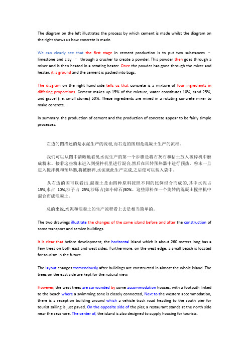
The diagram on the left illustrates the process by which cement is made whilst the diagram on the right shows us how concrete is made.We can clearly see that the first stage in cement production is to put two substances –limestone and clay –through a crusher to create a powder. This powder then goes through a mixer and is then heated in a rotating heater. Once the powder has gone through the mixer and heater, it is ground and the cement is packed into bags.The diagram on the right hand side tells us that concrete is a mixture of four ingredients in differing proportions. Cement makes up 15% of the mixture, water constitutes 10%, sand 25%, and gravel (i.e. small stones) 50%. These ingredients are mixed in a rotating concrete mixer to make concrete.In summary, the production of cement and the production of concrete appear to be fairly simple processes.左边的图描述的是水泥生产的流程,而右边的图则是混凝土生产的流程。
雅思写作小作文范文 雅思写作地图题map 学校变化.doc

雅思写作小作文范文雅思写作地图题map 学校变化今天我们雅思写作小作文范文的相关文章来研究下地图题。
与听力中的地图题不同,雅思写作中的地图题往往会有两张不同时段同一地点的图片。
让大家比较其中的相同点和差别。
这种题型过去考得比较少,但近几年来有逐渐增多的趋势,甚至有时候会连着几场出现。
小编准备了一篇考官范文,以供大家参考。
雅思写作小作文题目he diagrams below show the site of a school in 2004 and the plan for changes to the school site in 2024.Summarise the information by selecting and reporting the main features, and make comparisons where relevant.雅思写作小作文范文The two pictures compare the layout of a school as it was in the year 2004 with a proposed site design for the year 2024.这两张图片比较了一个学校2004年的布局与计划在2024年实现的设计。
It is clear that the main change for 2024 involves the addition of a new school building. The school will then be able to accommodate a considerably larger number of students.很明显,2024年最主要的改变是增加了一座新的学校建筑。
学校到时候将能够容纳更多的学生。
In 2004, there were 600 pupils attending the school, and the two school buildings were separated by a path running from the main entrance to the sports field. By 2024, it is expected that there will be 1000 pupils, and a third building will have been constructed. Furthermore, the plan is to join the two original buildings together, creating a shorter path that links the buildings only.2004年,有600名学生在此上学。
雅思小作文地图题
主一
• The first potential location (S1) is outside the town itself, and is sited just off the main road to the town of Hindon, lying 12 km to the northwest. This site is in the countryside and so would be able to accommodate a lot of car parking. This would make it accessible to shoppers from both Hindon and Garlsdon who could travel by car. As it is also close to the railway line that links the two towns to Cransdon (25 km to the south-east), a potentially large number of shoppers would also be able to travel by train.
主一
• Looking first at the one before construction, we can see a huge island with a beach in the west. The total length of the island is approximately 250 metres.
重点词汇补充:
(3)A被B环绕 A is surrounded by B (4)A与B平行 A is parallel to B. (5)A在B内部的某个部位 A is in the eastern/ southern/ western/ northern part of B.
雅思写作地图题专项
地理变迁题--描述的是一个地方(多为一个城镇)在一段时间的发展变化。
时态如果地图题反映的是一个地方在过去的一段时间的变化,文章用一般过去时。
如果地图题反映的是一个地方在将来一段时间的变化趋势,文章用一般将来时或表“估计”的词汇。
如果地图题反映的是一个地方从过去到现在的变化,可用现完成时。
如:现在停车场改成了一个剧院。
The car park has been removed and replaced by a theatre.城镇A的家庭数量从1937年到2020年将翻一番。
The number of homes in Town A is likely to double(is likely to= is predicted to /is estimated to /is expected to )又可为:It is likely that the number of homes in Town A will double.(it is likely that = it is predicted/estimated/projected/ expected that…..)细节变化地图每个细节变化都要提到,不要忽视一个细节语态地图题用被动语态如:2000年在城镇A 新建了一个医院:A new hospital was established in Town A in 2000. 地图题的书写顺序:时间顺序和空间顺序考生在考前对方位词进行总结。
地图题的方位我们说东西南北,不说成左右。
A 在B 的东方/西方/南方/北方A is/ lies/ is located/ is situated in/on / to the east/west/south/north of B(in 表A 在B 内部,ON 表A 和B接壤,TO 表A 和B 分开)A 在B 内部的某个部位A is in the eastern/ southern/ western/ northern part of B.A在B 西北部的120 千米处A lies 120 km to the northwest of B.A 在B…..角落A is at/in the south-eastern corner ofB ( at 表示A 在B 外部,in表A 在B 内部)在河流或道路的南边/北边等On the south/southern side of the riverOn both sides of the roadOn the other side临近马路的地区The area adjacent to/ near /next to/ just off the road在道路或河流的最南端At the southern end of the riverA 在B 的对面A is on the opposite side of BA is opposite BA 在B 东部的边界上(A 在B外部)A is on the eastern border of BA 在B 东部边缘上(A 在B 内部)A is on/ along the eastern edge of B“变化”词汇地图题描述的是一个地区的变化,那么“变化”词汇必须过关。
地图题变迁形
However, in the next two decades , the number of students in this school will increase to 1000. The original sports field will be replaced by the third building. Additionally, two former buildings is expected to be joined together , creating a shorter path which will link three buildings merely. Meanwhile, next to the third building, the second car park is predicted to be constructed, which will be connected with the main entrance by a newly-paved road. A new and smaller sports field is projected to be built on the opposite side of the third school building.
地图题
变迁型
变迁型 注意事项: 1. 分段:按年份分段,如果每个年份的内容很
少,一起写 2.时态问题: 根据图来变化 3.描写顺序(时间+空间) 4.词汇表达 5. 句式变化(主语替换,从句运用)
变迁型
The diagrams below show the site of a school in 2004 and the plan for changes to the school site in 2024.
流程图/地图题高分范文
The process chart illustrates how pulp and paper are made. It is clear that there are three distinct stages in this process, from the initial extraction of pulp to the eventual production of both the boxes and the paper separately.In the first stage, we can see that the pulp is made from logs that are cut from the trees. After being chipped, the sawdust will be thrown into a digester and the washer to get filtered. When it is fully screened by the pulp screen, the rough material will be used for making boxes whereas the refined one is made for printing. The procedure to make the rough paper is to first mold the pulp, then dry it and roll it up with pulp reef. After being cutting up roughly the same size, they will be wrapped in bales in boxes.As for the refined paper, after being cleaned, the refined will go through the same procedure of being dried as the rough one does. But later it will get reinforced by the pulp press and then is sent through the dryers again. Finally the paper are formed and packaged in rolls.The flow chart describes the process of how smoked fish are acquired, prepared and distributed. There are thirteen procedures in total to cover the whole procedure from where the fish are captured to where they are being sold.First of all, the fish can be accessed from the port after being captured by fishermen. They will be first put in a freezer to ensure their freshness. During the preparation, when they are fully thawed, they will be cut open and put into salt water to get colored. After going through the preservation process, it will be about the right time to get down to business and smoke the fish. Then the fish will be packaged with boxes and thrown back into the freezers in which the temperature remains at zero degrees centigrade. At last, these packaged fish will be distributed to fish shops where people can purchase and enjoy them.3. The flow chart bellows represents how pencils are made from trees. There are precisely twelve procedures involved in the whole process from when the trees were still saplings to the point where they are made into pencils.First of all, it takes about four months for the sapling to grow and then they will get replanted. In another three years, they got obviously bigger and as fourteens years gone by after that, the trees will be cut down in preparation for the pencil making. The logs will be cut into thin slats and they required about 60 days to get treated. The slats are then stained and grooves and are cut into one surface. After that, prepared leads are placed into the grooves and a second slat is placed on top and bonded with the first. This ‘pencil sandwich’ is then passed through a milling process to separate the individual pencils. At last, the pencil is painted, sharpened, stamped and then finally packaged.4. The maps below display the layout of a conference center of its present and future form.The conference center is now built close to a main road and it consists of two main sections where the left part is for conferencing and business use while the right part serves the function of recreational use. Two meeting rooms are established next to the hall and right opposite the meeting room and the hall stand the toilet, reception and a café. For the recreational area, the coverage of the gardens is relatively small as most of the space is taken by the parking lot. Car-drivers can have access to the parking lot from the entrance/exist facing the hall.Regarding the plan of the center in the future, the two meeting rooms will be converted into three smaller ones while half of the space of the hall next to the meetings rooms will be turned into a café with a kitchen. The toilet and the reception will remain unchanged but the caféwill be changed into a fitting room. As for the recreational district, the gardens are extended to cover nearly the same space as the parking lot. As the space between the two sections is narrowed due to the changes, the entrance and the exit are moved to the side towards the main road.5. The maps below illustrate the layout of the same town in 1700 and 2000 respectively.In the first map of Bridgetown, we can see that a river travels northeast-southeast direction dividing the town into two main sections. On the one side where stand a marketplace, the woods and a castle and the other side is entirely covered by farmland. Over the river is a bridge whose two ends are connected with two roads.In the year of 2000, one of the most significant changes that took place is the appearance of the railway line right across the river. To the southwest of the river, the woods obviously get shrunken in order to give way to the railway line and the castle is converted into a school. Next to the railway line is the marketplace that remains unchanged. On the other hand, the area that used to be agricultural is now residential and is full of buildings. What is worth mentioning is the bypass built over the river that joins the roads on two sides seems to offer more convenience for the traffic in town.6. The maps below depict the changes that museum has experienced from the year of 1990 to 2010.The main building of the museum is built close to a rectangular shape of garden and nearby a cottage area. Inside the building, you can find three main components and they are store, exhibition and shop. Right across the path are the parking lot and a garden that is about one third of the size of the parking lot.By the time of 2010, several changes take place within the museum and its surroundings. First of all, the store and the shop get slightly bigger than they were while the exhibition area shrinks a little bit as shop was extended to cover some of its space. The museum gains its space by demolishing the cottage nearby and turns it into a coffee house. The small garden next to the parking lot is converted to a car parking area as well and the exit that used to be at the cottage district is now removed to the new parking lot. The only two regions that are remain unchanged are the big garden and the path.。