苏伊士运河船舶吨位丈量规则使用方法
船舶吨位的计算方法

船舶吨位的计算方法船舶吨位的计算方法船舶吨位是船舶大小的计量单位,可分为重量吨位和容积吨位两种:船舶的重量吨位1、排水量吨位排水量吨位是船舶在水中所排开水的吨数,也是船舶自身重量的吨数。
排水量吨位又可分为轻排水量、重排水量和实际排水量三种:1)轻排水量又称空船排水量,是船舶本身加上船员和必要的给养物品三者重量的总和,是船舶最小限度的重量。
2)重排水量又称满载排水量,是船舶载客、载货后吃水达到最高载重线时的重量,即船舶最大限度的重量。
3)实际排水量是船舶每个航次载货后实际的排水量。
排水量的计算公式如下:排水量(长吨)=长*宽*吃水*方模系数(立方英尺)/35(海水)或36(淡水)(立方英尺)排水量(公吨)=长*宽*吃水*方模系数(立方米)/0.9756(海水)或1(淡水)(立方米)排水量吨位可以用来计算船舶的载重吨;在造船时,依据排水量吨位可知该船的重量;在统计军舰的大小和舰队时,一般以轻排水量为准;军舰通过巴拿马运河,以实际排水量作为征税的依据。
2、载重吨位表示船舶在营运中能够使用的载重能力。
载重吨位可分为总载重吨和净载重吨。
1)总载重吨是指船舶根据载重线标记规定所能装载的最大限度的重量,它包括船舶所载运的货物、船上所需的燃料、淡水和其他储备物料重量的总和。
总载重吨= 满载排水量- 空船排水量2)净载重吨是指船舶所能装运货物的量大限度重量,又称载货重吨,即从船舶的总载重量中减去船舶航行期间需要储备的燃料、淡水及其他储备物品的重量所得的差数。
船舶载重吨位可用于对货物的统计;作为期租船月租金计算的依据;表示船舶的载运能力;也可用作新船造价及旧船售价的计算单位。
船舶的容积吨位船舶的容积吨位是表示船舶容积的单位,又称注册吨,是各海运国家为船舶注册而规定的一种以吨为计算和丈量的单位,以100立方英尺或2.83立方米为一注册吨。
容积吨又可分为容积总吨和容积净吨两种:1.容积总吨又称注册总吨,是指船舱内及甲板上所有关闭的场所的内部空间(或体积)的总和,是以100立方英尺或2.83立方米为一吨折合所得的商数。
船舶通过苏伊士运河操作要点

船舶通过苏伊士运河操作每年通过苏伊士运河的船只高达两万多艘次。
随着改革开放和对外贸易的飞速发展,我国远洋船队每年通过苏伊士运河的艘次还会逐年增长,我国的船舶是苏伊士运河的大客户。
远洋船员,特别是远洋船长应该对苏伊士运河有一个更系统、更全面的了解,以便能在通晓运河各项规定的基础上,提前做好过运河的准备,对全过程胸有成竹、有备而来、有条不紊、信手拈来,做到严格遵守航行规定,确保安全和顺利通过苏伊士运河。
综合远洋船舶多次通过该运河的实践,重新研读苏伊士运河航行规则(埃及苏伊士运河当局1986年1月版和l992年1月版及现行运河当局的历次修订),从理论和实践结合的高度,进行分析和总结船舶通过苏伊士运河操作,对确保安全顺利通过苏伊士运河大有裨益。
船长要不嫌麻烦、不吝辛苦,笔头要勤,每一次通过运河都要详细记录,不断总结积累,常年坚持,必有收获。
1 运河概况苏伊士运河是世界上最著名和最重要的人工运河,1859年由英法等国承办开凿,费时十年,1869年凿成通航。
从此沟通了地中海和红海的水上通道,使欧洲到印度洋和太平洋的航程,比绕道好望角航行缩短4859nm,节省燃油消耗达5O0-700mt,从而大幅度地降低了海上运输的成本,同时也增加了海上航行安全和可靠程度。
苏伊士运河的地理位置也极为重要,运河本身就是亚非两大陆的分界线,又是联接欧、亚、非三大洲的交通要道,因而苏伊士运河除了有着极为重要的航运价值外,其战略地位也不可忽视,1956年7月埃及政府宣布收回运河主权,1957年对外开放使用,1967年埃以战争期间运河被迫关闭,1975年6月又重新复航。
1981年埃及政府在日本、意大利的帮助下,完成了第一期的拓宽和疏深工程,提高了运河的通航能力。
目前通过运河的最大吃水深度为16.15m(53英尺),15万吨船只可满载通航,40万吨船只可半载通行。
1988年在塞得港17km处.又开僻一条长为19.5km的支路(By Pass),现已专供北上船舶出口,和南下船舶吃水超过11.58m(38英尺)的船只使用。
船舶吨位丈量计算

编号:复核日期:一、基本数据二、复核记录编号: _____________________检查人员检查地点检查时间一、基本情况二、检查项目记录项目记录情况注:计算实际总容积是用于判断吨位丈量是否有误,其中型容积VI所要求记录的参数误差较大可初步判断吨位丈量有误,V2(V3、V4)测量的数据可大致判断船图一致性。
督查机构编号:一、基本情况二、督查项目记录注:船图一致性可用《船舶吨位丈量检查登记表》所测量数据作判断,必要时可登船核实。
督查人员直督查时间:填写说明:应依据《船舶国籍证书》、《检验证书簿》中的相关项目,填写《检查表》第1 项“船舶基本信息”和第2项“船舶吨位证书信息”;应按照《检查表》第3项“现场勘验记录”的内容,完成船舶现场勘测;依据“船舶吨位丈量计算参考指南”(见附件3)的办法,对船舶总吨、净吨进行简单计算,并将适用方法及计算过程填写在《检查表》第4项“吨位核准评估” 一栏中;对发现计算结果与证书标注吨位明显不符(误差超过10%),应在第5 项“是” 一栏标注否则在“否” 一栏标注“/”;在第5项“是”中标注的船舶,在第6项中标注“V”。
附件5专项检查缺陷船舶汇总表__________ 海事局附件6船舶吨位丈量计算参考指南“大船小证”问题的出现一般有两种方式:一是船检证书上的船舶尺度与实船不一致,本身就偏小,从而计算的吨位偏小,这是主要现象;另一种情况是船舶尺度没有太大的误差,但计算误差较大,结果偏小造成“大船小证”问题。
(一)经验判别方法:为了积累甄别“大船小证”的基本知识和经验,监督人员在进行船舶安全检查和签证时,可记录下船舶的“船长”、“型深”、“型宽”以及船舶种类和船舶总吨、净吨。
通过积累,找出船舶尺度、种类与吨位之间的大致对应关系,以便从中找出定性判断“大船小证”基本经验。
下面表格是部分船舶主尺度与船舶吨位之间的对应关系,从该表可以总结出定性大致判断船舶吨位的基本经验。
船舶尺度与船舶吨位(二)实际丈量估算方法:各级海事监督部门在现场检查中,对一般货船吨位确有怀疑的,可以用下列估算公式对船舶总吨和净吨进行大致的估算(这个公式不适用于川江汽车滚装船、集装箱船等在量吨甲板以上仍然载货或载客的船舶。
船舶吨位丈量

2.定义(节选)
免除处所 :不计入围蔽处所容积之内。
2.定义
常见免除处所1
2.定义
常见免除处所2
2.定义
常见免除处所3
3.总容积V的组成部分
总容积V按位置可分为:上甲板以下围蔽处所 容积V1和上甲板以上围蔽处所容积V2。
V2 V1
4.丈量所需的图纸资料
总布置图、型线图、静水力曲线图(或计算 书)、邦氏曲线图(或计算书)、基本结构 图、横剖面图、上层建筑及甲板室结构图。 V1、 V2的计算均根据图纸资料进行计算,所 有数据均取自图纸资料。
计算方法
1.无舱盖的货舱口的容积 舱口围板的平均长度、平均宽度、平均高度相乘。 2.集装箱高出甲板或平台或舱口围板以上的容积 载货面积乘以最大装箱数时集装箱高出甲板或平台或舱口
围板以上的平均高度。只装运空集装箱的船舶,平均高度 大于5.2m时,取5.2m。 3.半舱船货舱口的容积 舱口围板的平均长度、平均宽度、0.1倍船宽相乘,舱口 围板平均高度大于0.1倍船宽时,取平均高度。
净吨位符号为NT,是Net Tonnage的缩写, NT =K2 GT,系数K2根据船舶种类选取。同 样NT是一个数值,不以m3作为单位。
4.海船吨位丈量法规以往版本
(1)1959年船舶吨位丈量规范(适用于海船, 河船参照)
(2) 1977年船舶吨位丈量规范(适用于国 际航行船舶)
(3) 《海船吨位丈量规范》(1985)
满载排水量从重量方面表示船舶大小。满载排水量 主要用于军舰的分类。同类型军舰中满载排水量越 大,表示船舶越大,武器的攻击力越强。
吨位从容积方面表示船舶大小。船舶吨位越大,表 示船舶越大。
2.总吨位
总吨位是表示丈量确定的船舶总容积。总吨位数值 根据丈量计算所得的船舶总容积(V)数值确定, 但不直接等于船舶总容积(V)数值。
苏伊士运河,巴拿马运河对航行船舶的要求

苏伊⼠运河,巴拿马运河对航⾏船舶的要求苏伊⼠运河对航⾏船舶的要求⼀、船舶舱室要求1.为引⽔员提供适当的起居处所(⾼级船员级)。
2.为过运河时在船上的6~9名带缆艇艇员和2名看管运河探照灯的岸上电⼯提供⼀个有遮蔽的处所。
⼆、系泊索在甲板上适当地点⾄少应准备6根具有索端眼环的柔性可浮式系泊索,以备必要时在运河内靠绑⽤。
其布置务必做到能迅速操作。
如果船上备有牵引系泊钢索,则上述绳索可减为4根。
对油船、液化⽯油⽓船、液化天然⽓船或任何装运易燃物质船舶,禁⽌使⽤在操作时会发⽣⽕花的系泊索。
为了便于操作,要求钢质系泊索周长不⼤于140毫⽶(5.5英⼨)。
三、防⽕钢丝索所有船舶应备有防⽕钢丝索2根,分别系牢在船⾸尾两端,并垂挂在舷外,以备应急时使⽤。
四、舵⾓指⽰器和主机转速指⽰器在驾驶台应安装舵⾓批⽰器和主机转速批⽰器,其位置与照明便于引⽔员不离开岗位⽽能读取。
五、探照灯⼀盏探照灯设置在船⾸端中⼼轴线上,要求能照亮(约1勒克司)运河前⽅1800⽶远处,并能分为左右各5o⼆个光束,此⼆光束间的暗区可从0o调节到10o。
⽩炽灯功率对于30000总吨以下船舶为2000⽡。
30000总吨以上船舶为3000⽡。
如为其他型式灯具其发光强度不⼩于3×10⁶坎德拉。
电器系统(开关、插头、插座、电缆)应为⼀级船⽤型。
防护等级符合IP55或类似标准。
严格要求在某⼀发电机发⽣故障停机时,确保探照灯不中断⼯作。
探照灯⼀般可以租⽤,但对球⿐⾸船、液化⽯油⽓运输船和液化天然⽓运输船⼀定要⾃备探照灯。
直接从海上进⼊运河的船舶也必须设置⾃备的探照灯。
六、⾼架灯(甲板灯)⾼架灯(OVERHEAD LIGHTS)应⾜够照亮本船周围所有⽅向,构成的照明区在⽔平⽅向最⼩距离为200⽶(约650英尺)。
七、桥楼探照灯在桥楼任何⼀舷设置桥楼探照灯作为过河和系泊时照亮河岸⽤。
构成照明功率在⼤⽓传递因数T=0.74时其照度约为4勒克司。
最⼩距离为200⽶。
船舶部位尺度吨位和水尺解析
(一)船舶各部位及舱室名称
1
整理课件
1.位置名称
如图1-l-1所示,船的前端叫做船首,后端叫做船 尾。而船首两侧船壳弯曲处叫做首舷,船尾两侧 船壳弯曲处叫做尾舷。船的两边叫做船舷。船舷 侧板与船底板交接的弯曲部分叫做舭部。
船舶的首尾连线称为首尾线(或纵中线、中央 线),它将船体分成左右两半,从尾向首看,在 首尾线右边的部分叫做右舷,在左边的部分叫做 左舷。
36
整理课件
②净载重量
净载重量是指船舶具体航次所能装载货物的最大 重量,等于总载重量减去航次总储备量(包括航 次所需的燃润料、淡水、粮食、供应品、船员、 行李等重量)及船舶常数,即:
净载重量=总载重量一航次总储备量一船舶常数 其中,船舶常数是指船舶经过一段时间营运后
的空船重量与船舶出厂时的空船重量的差值。
(l)最大长度
船舶最前端与最后端之间包括外板和两端永久性 固定突出物(如顶推装置等)在内的水平距离。 最大长度就是船舶的实际长度。
26
整理课件
(2)最大宽度
包括外板和永久性固定突出物(如护舷材、水翼 等)在内的垂直于中线面的船舶最大水平距离。 最大宽度就是船舶的实际宽度。
27
整理课件
(3)最大高度
10
整理课件
(2)型宽
在船体的最宽处,由一舷的肋骨外缘量至另一舷 的肋骨外缘之间的水平距离,如图1-l-5所示。
11
整理课件
(3)型深。
在船长中点处,由平板龙骨上缘量至干舷甲板横 梁上缘的垂直距离;对甲板转角为圆弧型的船舶, 则由平板龙骨上缘量至横梁上缘延伸线与肋骨外 缘延伸线的交点,如图1-1-5所示。
45
整理课件
19
苏伊士运河航行规则
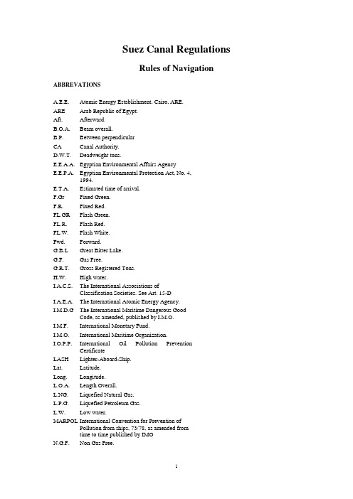
Suez Canal RegulationsRules of Navigation ABBREVATIONSA.E.E. Atomic Energy Establishment, Cairo, ARE.ARE Arab Republic of Egypt.Aft. Afterward.B.O.A. Beam overall.B.P. Between perpendicularCA Canal Authority.D.W.T. Deadweight tons.E.E.A.A. Egyptian Environmental Affairs AgencyE.E.P.A. Egyptian Environmental Protection Act, No. 4,1994.E.T.A. Estimated time of arrival.F.Gr Fixed Green.F.R. Fixed Red.FL.GR Flash Green.FL.R. Flash Red.FL.W. Flash White.Fwd. Forward.G.B.L Great Bitter Lake.G.F. Gas Free.G.R.T. Gross Registered Tons.H.W. High water.I.A.C.S. The International Associations ofClassification Societies. See Art. 15-DI.A.E.A. The International Atomic Energy Agency.I.M.D.G The International Maritime Dangerous GoodCode, as amended, published by I.M.O.I.M.F. International Monetary Fund.I.M.O. International Maritime Organization.I.O.P.P. International Oil Pollution PreventionCertificateLASH Lighter-Aboard-Ship.Lat. Latitude.Long. Longitude.L.O.A. Length Overall.L.NG. Liquefied Natural Gas.L.P.G. Liquefied Petroleum Gas.L.W. Low water.MARPOL International Convention for Prevention ofPollution from ships, 73/78, as amended fromtime to time published by IMON.G.F. Non Gas Free.N.R.T. Net Registered Tonnage.SCA Suez Canal Authority.SC Suez Canal.SC.G.T. Suez Canal Gross Tonnage.SC.N.T. Suez Canal net Tonnage.SC.T. Suez Canal Tonnage.S.D.R. Special Drawing Rights.S.E.S. Ship Earth StationS.T.S. Ship to Ship (Trans-shipment operation). SOLAS International Convention for the Safety of Life at Sea,. 74/78, as amended from time to timepublished by I.M.O.SC.R. Suez Canal RegulationsU.L.C.C. Ultra Large Crude Carrier Ship.V.L.C.C. Very Large Crude Carrier Ship.Part I: NAVIGATIONGENERALITIESArt. 1 - Transit through the Suez CanalTransit through the SC is open to vessels of all nations subject to their complying with the conditions stated in the present Rules of Navigation. All references and circulars which shall be issued by the SCA will constitute an integral part of these rules. Vessels also have to comply with the provisions of the International Regulations for SOLAS and its amendments. MARPOL 73/78, as well as the provisions of the International Regulations for Preventing Collisions at Sea and all laws, orders, and regulations issued by the Egyptian Government.The SCA reserves the right to refuse access to Canal waters, or order the towage or conveying of vessels considered dangerous or troublesome to navigation in the Canal. (Non or erroneous declaration of dangerous cargo see art. 47 bis). By the sole fact of using the Canal waters, masters and owners of vessels bind themselves to accept all the conditions of the present Rules of Navigation, with which they acknowledge being acquainted, to conform with these conditions in every respect, to comply with any requisition made with a view to their being duly carried out, and to adhere to CA private Code of Signals as shown in Part III of these Rules.Art. 2 - Agents:Every vessel (other than navy ships) intending to transit the Suez Canal or staying at Port Said or Port at the Suez, or at the Suez Canal basins or docks must have a shipping agent. SCA confirms that it has no agents or representatives abroad. The Egyptian Authorities are to be notified of intended transit of navy ships in SC viz., Ministry of Foreign Affairs, Ministry of Defence as well as Ports and Lights Administration.Art. 3 - Canal Waters :Canal Waters mean the Canal proper, and the the waters within the Canal Authority concession adjacent to the Canal proper, Port Said Harbor and Port of Suez.The Canal proper : As to its length, is reckoned to run from Km 3.710 West Branch for vessels entering from Port Said Harbor and from Km 1.333 East Branch for vessels entering through the East Approach Channel to Hm. 3 at Suez, including the two channels of the G.B.L and all Canal by-passes.As to its width, the Canal is bounded by two banks when they are immersed in water. If the banks are submerged, the width of the Canal is limited to the perpendiculars at the point of intersection of the submarine bank with the horizontal plane corresponding to the maximum draught authorized including squat access channels there to Port Said Eastern and Western entrance channels, Suez Entrance channel which includes the Port of Suez Eastern channel leading to the Canal entrance.Art. 4 - Responsibilities:See also: Art. 16 para. A, Art. 55 para. 5, Art. 59 para. 3, Art. 60 para. 4,5, Art. 62 para. 4.When on Canal Waters or at its ports or roads, any vessel or floating structure of any description are responsible for any damage and consequential loss she may cause either directly or indirectly to herself or to CA properties or personnel or to third party.The vessels' or floating structures' owners and /or operators are responsible without option to release themselves from responsibility by limited liability. The words (owners and/or operators) for the purpose of the present article, shall be considered to mean person/persons or corporate body responsible for the vessel at the time of navigational accident or incident. Moreover, the vessel guarantees to indemnify the CA in respect of any claim against the latter by reason of any damage, whatever, she may cause either directly or indirectly to third party.The vessel waives the right to claim the SCA for any damages caused by third party that she may sustain while on Canal Waters.Art. 5 - Temporary delaying of vessels:The Canal Authority may delay a vessel for the purpose of investigating any claim or dispute that may arise, or any formal or informal complaint, or allegation of violation of the laws of the Canal or for security reasons.A vessel may be delayed until, in the opinion of CA, its tenderness, trim, list, cargo, hull, machinery have been put into such condition as will make the vessel reasonably safe for her passage through the Canal.No claim for damages is accepted or considered because of any such temporary delaying of vessels. Art. 6 - Pilotage:Pilotage is compulsory for all vessels, whatever be their tonnage, when entering, leaving, moving, changing berth or shifting on Canal Waters or Port Said and Suez harbors. Any exemption must be explicitly authorized by the Suez Canal Authority (See Art. 11, Item D).Except ed is Egyptian vessels under 300 tons SC.G.T. authorized to work in Canal Ports and Accesses, also Egyptian fishing vessels under 300 tons SC.G.T. (At Port of Suez : 300 tons SC.G.T.) However, if transiting Canal, the above is not applied.Art. 7 - Changing Berth in Roads Anchorage:Vessels at Port Said Anchorage Areas (Northern and Southern) Suez Roads, the Bitter Lakes and Timsah Lake are not authorized to change berth, anchorage or make fast alongside other vessel or carry out any cargo operations without explicit authorizationCHAPTER I: SUEZ CANAL NA VIGATION FEATURESSECTION I – APPROACHESArt. 8 - Port Said:GENERAL :Fifteen miles before arrival to FAIRWAY Buoy("All buoys in the Canal and Access Channels may be replaced by other smaller size". ), all vessels arriving from sea should contact the Harbor Office by V.H.F. (channel 16), if not able to R/T (2182 KH2) or by W/T, or by R. Telex and Inmarsat Via SC Marine Communication Center SUQ for instructions (See part III Art. 86 and 87).FAIRWAY BUOY :Position :Lat. : 31° 21'.32 NLong. : 32° 20'.81 ECharacteristics : V. Q.A - Anchorage Areas :All vessels arriving from sea have to anchor in the berth allocated to them, by the Suez Canal Port Authority.The incoming vessels have two anchorage areas :(1) Northern Area: comprises two zones :a) Zone One : For vessels with draught over 42 feet.This zone is limited as follows :North Limit: Lat. 31° 28'.50 NSouth Limit: Lat. 31° 27'.00 NEast Limit: Long. 31° 20'.00 EWest Limit: Long. 32° 18'.00 EVessels at anchor in this area, when entering the Eastern Channel, will proceed between the East and West buoys at Hm. 195 (course 194°) "All buoys in the Suez Canal and its approaches are fitted with Radar reflectors".Hm. 195:East WestLat 31° 25'.06 N Lat 31° 25'.16 NLong 32° 24'.30 E Long 32° 23'.85 EIsophase (4 sec.) (See Plan No. 2 Part II).b) Zone Two : For VLCC'S, 4th generation containerships,,3rd generation containerships and vessels over 39 feet draught up to 42 feet.This zone is limited as followsNorth Limit: Lat. 31° 25'.00 NSouth Limit: Lat. 31° 23'.20 NEast Limit : Long. 32° 20'.00 EWest Limit: Long. 32° 16'.00 EVessels at anchor in this area, When entering the Eastern Channel, will proceed between the East and West Light buoys at Hm. 135.Hm. 135 :Lat. 31° 21'.95 NLong. 32° 23'.10 EThe berths of this zone are called (V) berths and comprise the following :Center of circle (Radius 750 meters)Berth V1 Lat. 31° 23'.70 NLong. 32° 19'.50 EBerth V2 Lat. 31° 24.50 NLong. 32° 19'.50 EBerth V3 Lat. 32° 19'.50 ELong. 32° 18'.50 EBerth V4 Lat. 31° 24'.50 NLong. 32° 18'.50 EBerth V5 Lat. 31° 23'.70 NLong. 32° 17'.50 EBerth V6 Lat. 31° 24'.50 NLong. 32° 17'.50 EBerth V7 Lat. 31° 23'.70 NLong. 32° 16’.50 EBerth V8 Lat. 31° 24'.50 NLong. 32° 16'.50 E(2) Southern Area :For all other vessels, area is limited as follows:North Limit Lat. 31° 23'.05 NSouth Limit Lat. 31° 21'.25 NEast Limit Long. 32° 20'.50 EWest Limit Long. 32° 16'.70 EVessels at anchor in this area, when entering the Port of Port Said through the West Approach Channel proceed :Take on their starboard " Fairway Buoy" (No. 8) (No. 7) and (No. 6) Buoys.On the port there are 3 yellow buoys showing yellow lights,On reaching No. 5 pair of buoys at Hm. 80 showing F. Gr. & R. they will proceed through the old channel to Port (Course 217.5°).Berths in Southern area called (C):Center of Circle (Radius 500 meters).Berth ClLat. 31° 21’.50 NLong. 32° 20'.00 EBerth C2Lat. 31° 22'.10 NLong. 32° 20'.10 EBerth C3Lat. 31° 22'.70 NLong. 32° 20'.10 EBerth C4Lat. 31° 21'.50 NLong. 32° 19'.40 EBerth C5Lat. 31° 22'.10 NLong. 32° 19'.40 EBerth C6Lat. 31° 22'.70 NLong. 32° 19'.40 EBerth C7Lat. 31° 21'.50 NLong. 32° 18'.70 EBerth C8Lat. 31° 22’.10 NLong. 32° 18'.70 EBerth C9Lat. 31° 22'.70 NLong. 32° 18'.70 EBerth C10Lat. 31° 21'.50 NLong. 32° 18'.00 EBerth C11Lat. 31° 22'.10" NLong. 32° 1 8'.00 EBerth C 12Lat. 31° 22'.70 NLong. 32° 18'.00 EBerth C13Lat. 31° 21'.50 NLong. 32° 17'.30 EBerth C14Lat. 31° 22'.10 NLong. 32° 17'.30 EBerth C15Lat. 31° 22'.70 NLong. 32° 17'.30 E(3) Prohibited area for anchorage :The area between the East Limit of the two anchorage areas and the approach channels is prohibited for anchorage to all vessels and floating units.(4) Anchorage area for transshipment operationsa) Vessels up to 60 feet draught :North Limit: Lat. 31° 25' .00 NSouth Limit: Lat. 31° 24' .00 NEast Limit: Long. 32° 27' .00 EWest Limit: Long. 32° 26'. 00 Eb) Vessels over 60 feet draught :North Limit: Lat. 31° 27' .00 NSouth Limit: Lat. 31°' 26' .00 NEast Limit Long. 32° 28'. 00 EWest Limit Long. 32° 27' .00 E(5) Dangerous Areasa) Wreck :A wreck buoy is situated on the western side of a sunken ship at Hm. 195 west of the approach channels:Lat. 31° 25'.24 NLong. 32° 22'.98 EHeight 5 meters, painted black and red horizontal bands, with daymark 2 black balls, showing group FL,.W. (2) every 10 sec.b) Dumping areas :The hopper dredgers dredge underway for several months every year the entrance channels and dumpin the following areas:- 3140 meters east of the axis of the East Channel at Hm. 140.Lat. 31° 20'.80 NLong. 32° 25'.80 E- 4000 meters East of the axis of the East Channel at Hm. 80. approximately.Lat. 31° 18'.70 NLong. 32° 24'.70 EB - Port Said approach channels(1) Buoyage :The Port Said West approach channel extends from the port of Port Said till Hm. 80 where it joins the east approach channel Height of the buoy at Hm. 80 Green is 10 meters. The Port Said East Approach Channel extends front the land boundary, east of Port Said, till Hm. 195.The two channels are marked, on each side, by light buoys of 5 meters height (except from Hm. 195 till Hm. 135 east channel, the height of the buoys is 10 meters). The light is Red on the eastern side and Green on the western side.The buoys are as follows :a) East approach channel :The East Approach channel is buoyed as follows :- In the West: Green Daymark: Cone point up. FL. Gr. Lights.- In the east: Red, Daymark : Can F L. R. Lights.The 2 buoys indicating the northern end of the channel, at Hrn. 195, are Isophase (2 sec. ON, 2 sec. OFF). The distance between them is 745 meters.b) Junction of east and west approach channelsThree Yellow buoys, mark the junction of the East and West approach channels. They are placed at Hm, 83, Hm. 95 and Hm. 105.Buoy at Hm. 83: Yellow and Black in color, is fitted with N-Cardinal 2 Cones point up daymark and shows by night Q. FL. W (5) every 20 sec.Buoy at Hm. 95: Yellow in color, shows a F.Y. light.Buoy at Hm. 105: Yellow in color is fitted with a yellow St. Andrews Cross daymark and shows bynight Group FL.Y (4) every 15 sec.c) West approach channelThe buoyage of the west approach channel of Port Said harbor, is as follows:i - Port Said " Fairway Buoy"Off Port Said, a fairway light buoy, height 10 meters, painted Black with Yellow Horizontal stripes, surmounted by a daymark 2 cones point up, and showing V. Q.Lat. : 31° 21'.32 NLong.: 32° 20'.81 EBuoy No.8 Green Daymark: Cone point up. F.Gr.Light.Lat. : 31° 21'.13 NLong.: 32° 21',04 EBuoy No.7 Green Daymark: Cone point up. F.Gr.Light.Lat. : 31° 20'.52 NLong.: 32° 21'.31 EBuoy No. 6 Green Daymark : Cone point, up. F. Gr. Light.Lat. : 31° 19'.09 NLong.: 32° 21'.58 Eii-The west approach channel : is buoyed as follows-In the west: Green Daymark: Cone point up .F.Gr.Light.-In the east : Red, Daymark: Can F.R.Light.-Buoy No.5 of Hm. 80 East Red: Daymark: Can F.R.Lat. 31° 19'. 13 NLong. 32° 22'. 11 E-Buoy No. 5 of Hm. 80 West Green: Daymark: Cone. F. Gr.Lat. 31° 19'.30 NLong. 32° 21'.85 Ed) El Bahar TowerA guidance tower in position between the East and West approach channels:Lat. : 31° 18'.16 NLong,.: 32° 21'.58 EHeight 42 meters, painted white with red horizontal stripes.Characteristics :Beacon Call sign Q "_ _ . _ " Range 15 miles.Beacon light Iso. W (2)s Range 15 miles.Automatic fog horn.(2) Navigationa) Northbound VesselsAll northbound vessels use the east approach channel. The end of the Navigable channel is marked by 2 pair of Buoys at Hm. 195, Course : 014°. From Hm. 195, vessels are to steer North (000°) for 5 miles before altering to destination.Vessels leaving Port Said harbor to sea, use the west approach Channel. Course : 037.50 till Hm. 80 (Buoys No. 5) then steer (000°) to 5 miles north of tire buoy of Hm. 195 westLat. 31° 25'.16 NLong. 32° 23'.85 EBefore altering to destination.Vessels of the northbound convoys wishing to enter Port Said Harbor may proceed through the west channel (direct to their allocated berth in Port Said Harbor, only If the situation of traffic permits. Otherwise they have to proceed through the east approach channel till Hm. 195, then steer north (000') for 5 miles and head for the anchorage berth allocated by the Harbor office. This is to avoid crossing incoming vessels to the northern anchorage area.b) Southbound vesselsThe maximum draught authorized for southbound vessels is limited to 42 feet Southbound vessels rnay be authorized to transit with a draught from 42 feet up to 56 feet with special arrangement. on condition to comply with the tables of Art. 52, Table II giving the maximum draught according to the vessel's beam.VLCC's, in ballast or partially loaded. 4th Generation Containerships and 3rd Generation Containerships, LASH over 35.000 SC.G.T, L.P.G & L.N.G. (Loaded or N.G.F) and vessels having a draught of more than 42 feet and up to 56 feet maximum, have to use the east approach channel, Course : 194°. The said vessels enter the channel between FL.GR. buoys of Hm. 165 and Hm. 135.All other vessels, transiting the canal or berthing at Port Said, have to enter through the west approach channel. Course: 180° from the entrance, passing between the west green buoys and the east yellow buoys till Hm. 80, then alter course to 217.5' passing between green and red buoys, till Port Said HarborA fixed red light on a pylon on the North Quay of Abbas Basin in line with an occulting red Light on a pylon West of the Fuel Oil Tanks at Raswa, indicates the axis of the entrance channel to the harborC - Breakwaters :(1) The West approach channel is protected by two breakwatersa) The Western breakwater protecting the west approach channel is situated to the west of the channel and extends from land boundary till Hm.73 with a submerged part from Hm. 50. This part is marked by cigar shaped unlit buoys.b) The eastern breakwater extends from land boundary till Hm. 21.2, and has an occulting red light at its northern end.(2) Two breakwaters protect the east approach channel. The eastern extends for 2 Km from the land boundary, and the Western extends. for 0.53 Km from the land boundary. Each breakwater has a small fixed white light on its end.Art. 9 - Suez:Five miles before arrival to the first separation Zone Buoy, all vessels coming from sea should contact the Suez Canal Harbor Office by VHF (channel 16), if not able to, by R/T (2181 KHZ) or by W/T, or by R, Telex and Inmarsat via SC Marine Communication Center SUQ for instruction (See Part III, art.86 and Art. 87).A - Separation Zone :A separation zone has been established, extending 0.3 mile on each of the line connecting the two separation buoys mentioned hereafter. All vessels arriving or leaving have to pass the separation zone Buoys(l) on their Port Side.The separation zone buoys are:Separation zone buoy No. 1 (southern buoy):Lat. 29° 39'.49 NLong. 32° 32'.12 EHeight 6 meters, R. W. color with top mark Red ball and a fog horn. Showing LFI 10s and fitted with 5 miles Beacon (0). (3.10 cm)Separation zone buoy No. 2 (northern buoy):Lat. 29° 48'.55 NLong. 32° 32'.12 Eheight 6 meters, R. W. Top mark Red ball, showing Iso 6s with 5 miles Beacon horn (D) (3.10 cm)B - Anchorage areas :The incoming, vessels have two anchorage areas(1) "V" Area :For VLCC'S. 4th Generation Containerships, 3rd Generation Containerships, Lash Ships over 35000 SC.G.T., vessels over 38 feet draught, L.P.G and LNG vessels (loaded or N.G.F.) this area is indicated by :a) The Conry Rock Buoy :Lat. 29° 48'. 11 NLong. 32° 34'.22 EHeight 5 meters, Y.B.Y. West Mark showing Q (9) 15sb) South Shoal Buoy :Lat. 29° 38'.87 NLong. 32° 35'.98 EBlack, cone point up, showing Gr, Isophase (2 sec. ON - 2 sec. OFF).Berths of this area are called "V". Center of circle (Radius 833 meters).Berth V1Lat. 29° 46'.50 NLong. 32° 35'.00 EBerth V2Lat. 29° 45'.50 NLong. 32° 35'.00 EBerth V3Lat. 29° 45'.50 NLong. 32° 36'.00 EBerth V4:Lat. 29° 45'.00 NLong. 32° 37'.00 EBerth V5Lat. 29° 4'.50 NLong. 32° 36'.00 EBerth V6:Lat. 29° 44'.50 NLong. 32° 35'.00 EBerth V7Lat. 29° 44'.00 NLong. 32° 37'.00 EBerth V8Lat. 29° 43'.50 NLong. 32° 36'.00 EBerth V9:Lat. 29° 43'.50 NLong. 32° 35'.00 E(2) Waiting area :For other vessels:This Area is limited by the following buoys:a) Conry Rock :Lat. 29° 48'.11 NLong. 32° 34'.22 EHeight 5 meters, Y.B.Y - West Mark showing Q (9) 15s b) Buoy "M" :Lat. 29° 50'.00 NLong. 32° 35'.29 EHeight 5 meters, yellow cross and showing, F. Y.c) Buoy "N":Lat. 29° 50'.63 NLong. 32° 351.29 EHeight 5 meters, yellow cross and showing Qk. F. Y. d) Buoy "D":Lat. 29° 51.28 NLong. 32° 35.29 EHeight 5 meters, yellow cross and showing F. Y.e) Buoy "C":Lat. 29° 51’.93 NLong. 32° 35’.29 EHeight 5 meters, yellow cross and showing FL. Y.f) Buoy "B" :Lat. 29° 52'.06 NLong, 32° 34'.54 EHeight 5 meters, yellow cross and showing F. Y.g) Buoy "A" :Lat. 29° 52'. 17 NLong. 33° 33'.86 EHeight 5 meters, Yellow Cross and showing F. Y.h)Buoy Hm. 60.00 East HM. 60.00 West:Lat. 29° 52'.27 N Lat. 29° 52'.26 NLong 32° 33'. 16 E Long 32° 32',96 EHeight 5 meters, GreenCone point up and showing FL. Gr. Height 5 meters, RedCan and showing FL. R.i)Buoy Hm. 70.50 East HM. 70.50 West:Lat. 29° 51'.70 N Lat. 29° 51'.69 NLong 32° 33'.26 E Long 32° 33'.05 EHeight 5 meters, GreenCone point up, and showing FL. Gr. Height 5 meters, Red Can and showing FL. R.j)Buoy Hm. 80.50 East Hm. 80.50 West:Lat. 29° 51'.16 N Lat. 29° 51'.15 NLong 32° 33'.33 E Long 32° 33'.13 EHeight 5 meters, Green Cone pointup,and showing Occ. Gr. (1) 4 sec, Height 5 meters, Red Can and showing Occ. R. 4 sec.k) Position "R" :Lat. 29° 48'.52 NLong. 32° 33'.18 EC - Anchorage area for trans-shipment operations "S.T.S"(1) "A" area :Lat 29° 43'.00 NLong 32° 37'.00 ELat. 29° 43'.00 NLong. 32° 38'.00 ELat. 29° 42'.00 NLong. 32° 37'.00 ELat. 29° 42'.00 NLong. 32° 38'.00 E(2) "B" area :Lat. 29° 37'.00 NLong. 32° 37’:00 ELat. 29° 37'.00 NLong. 32° 38'.00 ELat. 29° 36'.00 NLong. 32° 37’.00 ELat. 29° 36’.00 NLong. 32° 38'.00 ED - Arrival to Suez for northbound vessels :Vessels coming front sea to transit the Suez canal or enter the Port of Suez, have to pass east of the separation zone. VLCC'S, 4th Generation Containerships, 3rd Generation Containerships and vessels over 38 feet draught have to anchor in the anchorage area specified for these vessels ("V" berths) in the berth allocated to each vessel by the SCA. Other vessels have to pass east of the separation zone and anchor in the waiting area as previously indicated.E - Prohibited area for anchorage :It is strictly forbidden for all Northbound vessels to anchor in the area limited as follows(1) In the norlh :Two buoys marking the dredged channel positionWestern Buoy:Lat. 29° 51'.15 NLong. 32° 33'.13 EEastern Buoy:Lat. 29° 5 1'. 16 NLong. 32° 33'.33 E(2) In the West :By the line joining the West buoy and position "P""P":Lat. 29° 48'.52 NLong. 32° 30'.90 E(3) In the East :By the line joining the East buoy and position "R" :"R":Lat. 29° 48’.52 NLong 32° 33’.18 E(4) In the South :By the line joining position "P" and position "R".F - Suez Entrance Channel(Including the Eastern Channel leading to the Canal Entrance).This channel is used for vessels entering or leaving Suez Canal and also by those entering Port of Suez and using its anchorage.This Channel is buoyed as follows:(1) A pair of light buoys at Hm. 80.5 "entrance buoys"The eastern buoy : Height 5 meters, Green, cone point up and showing oc. G 4 sec.The western buoy : Height 5 meters, Red. can daymark and showing oc. Red 4 sec. The distance between the eastern and western buoys is 340 meters(2) Proceeding Northward the channel is marked on both sides by light buoys, of 5 meters height .On The eastern side of the channel : the buoys are Green, cone point up and showing FL. Gr.They are placed in the following locationsHm. 70.50Hm. 60.00Hm. 44.40Hm. 24.00Hm. 14.00Hm. 7.00Km. 162.150 (Occ. Gr.)b) On the western side : the buoys are red, Can daymark, and showing Fl. red.They are placed in the following locations:Hm . 70.50Hm 60.00Hm. 44.40Hm. 21.00Hm. 17.20Hm. 1.00 (Occ. Red.)Course : From the Entrance Buoys (Hm. 80.50),(New Port Rock Channel), till the Green light buoy of Hm 24.00Northbound course is 352.5'Southbound course is 172.5'G - Canal south entrance :The Canal south entrance is marked by two light buoys of 7 meters height :The Eastern Buoy at Km. 162.150 : is Green, cone point Up and showing occ Green light (1) every 4 sec.The western buoy at Hm. 1.00 : Red, Can daymark and showing occ. Red light (1) every 4 sec.H - Port of Suez(1) Navigation :Port of Suez is delimited by the imaginary line which extends from Ras Adabeya to Eyoun Moussa and comprises the coastal zone north of this up to SC entrance.a) General rulesAll vessels shall conform to the International Regulations for Preventing Collisions at Sea. Navigation in the port is limited to approved channels only.Crossing or overtaking at the channels is strictly forbidden.Vessels must proceed in the port with caution and at a reduced speed.Vessels must not let go their anchors except in the anchorage areas.b) Traffic RegulationsVessels entering or leaving the port:- For vessels entering the port from sea and vessels leaving the port for sea, all movement shall be effected through the western channel, except for vessels anchored in 1C, 2C, 3C, 4C, 5C, which should use the eastern channel.Vessels entering the Canal :- From the Port and from Zone North West. of Green Island, they must comply to the following : Anchorages 8C to 16C and anchorage groups A and B.Vessels shall pass through the western channel, then south of Green Island to join the eastern channel and then proceed to the entrance of the Canal.- From zone north east of green island :Anchorage IC to 7C :Vessels shall proceed directly from their anchorages to the entrance of the Canal. If the number of vessels exceeds number of anchorages, vessels in excess shall anchor south of the western channel, parallel to anchorages 2A, 4A, 6A, 4B, 7B, making sure to leave the western channel clear for navigation at all times.- From zone South of Green Islands :Anchorages 1D to 6D :Vessels shall proceed directly from the anchorages to the Canal or to sea through the eastern channel. Vessels leaving the Canal-Direct to sea :They shall proceed through the eastern channel.-Anchoring in the Port:Anchorages Groups A & B. Zone N. W. of Green Island 8C to 16C :They shall proceed through the Eastern channel, then the Western channel and shall follow it till the place fixed for their anchorage.Zone N. E, of Green Island from 1C. to 7C. :Vessels shall come out of the Canal and proceed directly to this are.c) Priority of movement at the Port :Priority of movement in the port shall be as follows:Vessels leaving the Canal.Vessels proceeding to the Canal.Vessels coming from sea must wait outside the port till the Eastern Channel is clear,Vessels leaving the anchorages of the Port of Suez.。
第三章船舶最小干舷和吨位丈量
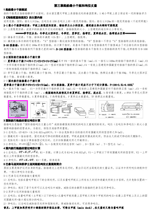
第三章船舶最小干舷和吨位丈量1船舶最小干舷概述船的干舷是泛指船舶静浮于水面时,自水面至露天甲板上表面舷边处的垂直距离。
1减小甲板上浪2保证有一定的储备浮力2《海船载重线规范》的主要内容适用范围:国际:船长L≥24m,总吨位在150总吨以上的一般民用船舶;国内:船长L≥20m的一般民用船舶(不适用军舰)2-1最小干舷影响因素:甲板上浪程度的因素、储备浮力大小的因素、灌进船主体内部的可能程度1)上浪程度因素:波浪中的纵摇及升沉运动的幅度、船舶舷弧的大小、上层建筑的地位和大小等有关。
******季节区分为:冬季北大西洋区、冬季区、夏季区、热带区、夏季淡水区、热带淡水区等********2)储备浮力因素:干舷、船体的丰满度(Cb值)、上层建筑、舷弧等。
3)灌进船主体内部的可能程度:“A”型船舶―载运液体货物的船舶;“B”型船舶―不符合“A”型船舶特点的其他船舶。
B-60型船舶:船长超过100m的B型船舶,在计算干舷时,其基本干舷取为B型船舶表列干舷值减去了对应船长的B型船舶表列干舷与A型船舶表列干舷值之差的60%。
B-100型船舶:B型船舶的基本干舷取为A型船舶的表列干舷,这种船称为B-100型船舶。
2-2国际航行船舶最小干舷计算1)夏季最小干舷F=F0+f1+f2+f3+f4+f5(mm)其中F0一船的基本干舷(mm);f1一船长L<100m的船舶干舷的修正(mm),f2一方形系数对船舶干舷的修正(mm),f3一型深对船舶干舷的修正(mm);f4一有效上层建筑和围蔽室对船舶干舷的修正(mm),f5一非标准舷弧对船舶干舷的修正(mm)。
2)季节区最小干舷:热带区最小干舷FR、冬季区最小干舷FD、淡水最小干舷FQ、热带淡水最小干舷FRQ、冬季北大西洋区最小干舷、船首最小高度。
2-3国内航行船舶最小干舷计算夏季最小干舷计算F=F0+f1+f2+f3(mm);对B型船舶,夏季干舷F还应不小于下式计算值:F=190+3.5L+0.035L2F一基本干舷(mm)、f1―方形系数对干舷的修正值(mm);f2一有效的上层建筑和围蔽室对干舷的修正值(mm);f3一非标0准舷弧对于干舷的修正值(mm)。