厦门轨道交通3号线复杂环境过海区间隧道设计关键技术
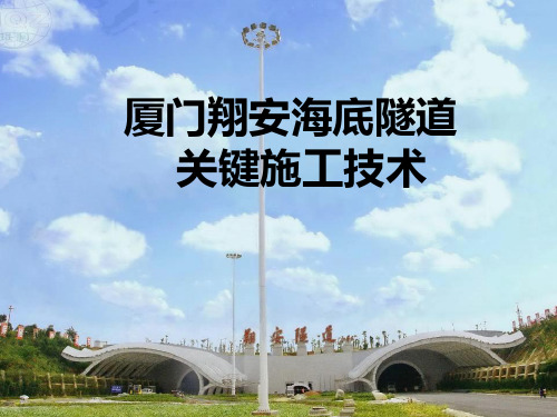
厦门翔安海底隧道施工技术总结PPT课件
5
厦门大桥
翔安区
海沧大桥
漳州
厦门东通道 (翔安隧道)
厦门岛
金门
鼓浪屿 翔安隧道地理位置图
6
该工程于2005年8月9日正式动工建设,2010年4月26日建成通车。建成后 ,翔安区到岛内将缩短50km的路程,厦门岛到翔安只需要15min。厦门海底隧 道工程建成交付使用后,对于提升厦门的城市功能,拓展城市发展空间,促进 区域社会经济协调发展,优化产业布局,改善厦门市的投资环境,加快厦门国 际化港口建设步伐,都将有着非常重大的现实意义。而作为我国内地第一条海 底隧道,对于探索出适合我国国情的海底隧道建造技术,为类似工程的动工兴 建,缩小与世界先进水平的差距,都将起到里程碑式的作用。同时也为我国深 海交通技术研究奠定了基础。
标标标 Z
翔
标标
安标
A2:3.14Km(YK5+930.5~YK9+700 )
A4:3.655Km(YK9+700~YK13+355 ) 标 标 标
N
标段划分示意图
15
8)环保、水保、文明施工要求高 厦门岛是国内著名的海滨旅游城市,风景优美,地域特色明显,翔
安隧道设计施工理念新颖,隧道建设的社会意义重大,对环保、水保、文 明施工要求高。
11
4)断面大,工法多 主隧道按3车道设计,最大开挖断面尺寸为17.04m×12.55m(170m2);
厦门翔安海底隧道科研总结报告

厦门翔安海底隧道科研总结报告引言厦门翔安海底隧道是中国第一条跨海大型公路隧道,连接厦门市翔安区和同安区,全长9.2公里。
该隧道的建设历时多年,涉及到了多个科研领域的研究和技术创新。
本文旨在对厦门翔安海底隧道的科研成果进行总结和分析,为隧道建设和相关领域的科学研究提供参考。
一、地质勘探与隧道设计厦门翔安海底隧道的建设首先需要进行地质勘探,以确定地质条件和隧道的设计参数。
通过大量的地质钻探和实地勘探,研究人员对海底地质结构进行了详细的了解和分析。
根据勘探结果,采用了盾构隧道的设计方案,以应对复杂的地质条件和地下水位的变化。
同时,还采用了先进的隧道支护技术和防水措施,确保隧道的稳定性和安全性。
二、水文气象研究海底隧道的建设需要对海洋水文气象状况进行长期观测和研究。
研究人员通过安装水文气象观测设备,对海底水流、潮汐、波浪等进行了系统的监测和分析。
这些数据为隧道的设计和建设提供了重要的参考依据,并且对后续的运维和管理也具有重要意义。
三、材料研究与施工技术隧道的建设需要使用大量的材料,并且要求这些材料具有良好的抗压、抗腐蚀和耐久性能。
科研人员通过对不同材料的试验和研究,选择了符合隧道建设要求的材料,并提出了相应的施工技术和标准。
同时,还对隧道施工过程中的各种技术问题进行了研究和解决,确保了施工的顺利进行。
四、隧道安全监测与管理为了确保隧道的安全运营,科研人员在隧道内部安装了多种监测设备,包括温度、湿度、位移等多个方面的监测。
这些设备能够实时监测隧道的运行状况,并及时预警和处理可能出现的问题。
此外,还制定了严格的隧道管理制度和应急预案,确保在突发事件发生时能够做出有效的应对和处置。
五、环境保护与生态修复隧道的建设不可避免地会对周边的自然环境产生影响。
为了保护海洋生态环境,科研人员对隧道建设过程中的环境影响进行了评估和研究,并提出了相应的环境保护措施和生态修复方案。
通过有效的环境管理和监测,隧道建设对周边环境的影响得到了最小化,同时也为海洋生态环境的保护和修复做出了贡献。
厦门轨道交通3号线超长跨海地铁隧道土建设计方案比选

厦门轨道交通3号线超长跨海地铁隧道土建设计方案比选
赵月
【期刊名称】《隧道建设》
【年(卷),期】2015(000)006
【摘要】依托厦门市轨道交通3号线跨海隧道工程,分析了超长跨海隧道的工程
特点、功能需求,针对特点和需求,从地质选线、工法选择和结构设计等方面,阐述了超长跨海隧道的土建方案设计理念,重点对施工采用“盾构+矿山+盾构”的组合工法、海域区间通风排烟道方案、风井位置选择和隧道结构断面形式选择进行了介绍。
并对大小洞组合方案、三洞组合方案和单大洞方案进行了方案比选,最终确定采用大小洞方案。
最后,对海底盾构与矿山对接、海底超长地铁隧道防灾救援、高水压跨海隧道结构防排水措施等关键技术问题进行了初探并提出了进一步研究的建议。
【总页数】7页(P547-553)
【作者】赵月
【作者单位】铁道第三勘察设计院集团有限公司,天津 300251
【正文语种】中文
【中图分类】U455.4
【相关文献】
1.厦门轨道交通2号线跨海段线路方案比选研究 [J], 马辉
2.厦门轨道交通3号线跨海段盾构滚刀磨损预测 [J], 杨育;
3.厦门轨道交通2号线跨海盾构隧道防水设计 [J], 张美聪
4.厦门轨道交通3号线跨海段盾构滚刀磨损预测 [J], 杨育
5.厦门轨道交通3号线工程跨海段通航安全评估 [J], 温清洪
因版权原因,仅展示原文概要,查看原文内容请购买。
论厦门地铁3号线过海段海底风化深槽全断面注浆施工方案优化

2019年7月帧施铁3龌优化饶剑(中铁(厦门)投资有限公司,福建厦门361000)[摘要]结合厦门地铁3号线过海段海底风化深槽开挖前超前注浆加固实例,介绍风化槽影响内基岩风化剧烈,节理和裂隙及其发育,岩体破碎,基岩裂隙水发育,水文地质特征复杂,透水性中等,施工难度极高,风险极大的工况下,通过超前注浆方案的不断优化,使得施工安全保障,进度保障。
[关键词]厦门地铁3号线;风化槽;注浆文章编号:2095-4085(2019)07-0101-021风化深槽工程概况正洞矿山法隧道水文地质复杂,隧道埋深浅,存在数个风化囊,风化深槽初期探查具体为左线4次穿越F4,Fl,f2,f4四个风化深槽,右线5次穿越F4,Fl,fl,£3,及f4五个风化深槽。
2风化槽地质情况F1风化深槽走向北西190,倾向西南。
通过水文试验证实,F1风化深槽碎裂状强风化带的裂隙水与海水存在水力联系,水位涨落较潮水位滞后3〜4h。
F2风化深槽走向北西240,倾向南西。
F3风化深槽走向北西30,倾向南西。
Fl,F2,F3风化槽深度一次加深。
风化槽物质主要为全风化花岗闪长岩,散体状强风化花岗闪长岩,碎裂状强风化花岗闪长岩。
散体状强风化花岗闪长岩主要呈密实砂砾混黏性土状。
F1风化槽相对完整,F2风化槽基岩破碎,F3风化槽岩体破碎,风化严重,F4风化槽分布在小石虎礁与厦门岛之间的水域,风化槽岩石风化严重,岩面埋藏较深,揭示岩体主要为中等风化花岗闪长岩。
风化槽主要穿越地层为散体状强风化花岗闪长岩,碎裂状强风化花岗闪长岩,中等风化破碎花岗闪长岩。
3施工方案(图1〜4)3.1原设计注浆方案原设计注浆范围为隧道开挖线以外5m,注浆段长度为30m,一个注浆段完成后留10m不开挖作为下一注浆段的止浆岩盘。
注浆前对超前探水孔内的水质进行化验,判断其腐蚀性,制成特制硫铝酸盐水泥单液浆,W/c=0.6〜1.2;并附以超细水泥浆液进行补充注浆,W/c=0.6〜1.2。
厦门地铁3号线跨海段主要工程地质问题及地质选线

厦门地铁3号线跨海段主要工程地质问题及地质选线
徐军政
【期刊名称】《铁道标准设计》
【年(卷),期】2015(000)011
【摘要】厦门地铁3号线跨海段线路为其控制性工程、重难点工程。
跨海地段地
质情况极其复杂,基岩面波动起伏,风化深槽发育,海底地形起伏较大,如何在地质复杂地段进行方案比选,是跨海段地质勘察的工作重点。
从地质条件、线路条件、风险、工期、造价等因素进行分析,对跨海段方案进行综合比选,确定出相对优化的推荐方案,为轨道交通跨海段的线位研究提供可借鉴的思路。
【总页数】6页(P18-22,23)
【作者】徐军政
【作者单位】中铁第一勘察设计院集团有限公司,西安 710043
【正文语种】中文
【中图分类】U231+.1
【相关文献】
1.西宁至成都铁路拉脊山越岭段主要工程地质问题及地质选线 [J], 季备
2.某铁路怒江至伯舒拉岭段主要工程地质问题及地质选线 [J], 霍欣
3.弥异所072:厦门地铁1号线跨海段 [J], 岳阳
4.弥异所072:厦门地铁1号线跨海段 [J], 岳阳
5.天平铁路越岭段主要工程地质问题及地质选线研究 [J], 陈秀义
因版权原因,仅展示原文概要,查看原文内容请购买。
厦门市人民政府关于轨道交通3号线南延段工程沙坡尾涉海段使用海域的批复
厦门市人民政府关于轨道交通3号线南延段工程沙坡
尾涉海段使用海域的批复
文章属性
•【制定机关】厦门市人民政府
•【公布日期】2022.04.06
•【字号】厦府〔2022〕140号
•【施行日期】2022.04.06
•【效力等级】地方规范性文件
•【时效性】现行有效
•【主题分类】海洋资源
正文
厦门市人民政府关于轨道交通3号线南延段工程沙坡尾涉海
段使用海域的批复
厦府〔2022〕140号
市资源规划局:
你局《关于轨道交通3号线南延段工程沙坡尾涉海段使用海域的请示》(厦资源规划〔2022〕130号)收悉。
根据《中华人民共和国海域使用管理法》《福建省海域使用管理条例》和《厦门市海域使用管理规定》等有关法律法规的规定,现批复如下:
一、同意厦门轨道交通集团有限公司使用厦门市思明区沙坡尾避风坞海域(用海范围坐标详见附件),用于建设轨道交通3号线南延段工程沙坡尾涉海段,用海类型为海底工程用海—海底隧道用海。
其中,海底隧道用海0.3060公顷,用海方
式为构筑物—跨海桥梁、海底隧道等,用海期限50年;施工期围海用海0.6699公顷,用海方式为围海—港池、蓄水等,用海期限5.5年。
二、请严格按有关规定给予办理相关手续,自批复之日起1年内未办理海域使用权登记的,本批复文件自动失效。
三、请你局会同有关部门加强项目用海监管,严格落实海域使用管理有关规定和要求。
附件:1.用海范围坐标表(略)
2.宗海位置图及宗海界址图(略)
厦门市人民政府
2022年4月6日。
厦门海底隧道讲义
覆盖层厚度与渗水率关系
6
2 水压力值的确定设计理念和施工理念
2.1 研究意义
• 对于海底隧道而言,除了承受围岩压力,还会有很 高的水压力; • 静水压力不能用任何地层成拱作用来降低; • 水压力值的大小是海底隧道衬砌结构设计的关键, 其不仅与水头压力有关,还与地下水的处理方式有 关(即全封堵方式和排导方式)。
21
挪威Oslofjord海峡隧道,采用冻结法穿越某破碎 带,该破碎带上部围岩含有粘土、砂子、卵石和块石 等,下部围岩为碎石,并含有粘土,渗透系数较小, 水压高达1.2MPa。为了确保工程如期完成,采用迂回 式施工法,做了350m长的旁通道,断面面积为47m2。
工作面前15m布点示意图
22
5 浅滩不良地质段的穿越措施
7
2.2 研究现状
目前,我国铁路隧道设计规范和公路隧道设计规 范在确定衬砌结构外水荷载时,从对地下水“以排为 主”的原则出发,不考虑水压力。 对于具有稳定的高水头海底隧道如何确定作用在 衬砌结构上的水压力,并不是一个简单的问题,通常 是参照水工隧道设计规范和经验,根据开挖后地下水 渗入情况,采用折减系数的方法对地下水位进行相应 的折减来计算隧道衬砌的外水压。 但是水工隧洞仅仅要求围岩的稳定性,并不需要 控制地下水的排放量,通常采用隧洞附近的天然排水 (如溶洞)或人工排水等措施来减小外水压力,而海 底隧道不能自然排水,显然从设计理念上就不适用于 海底隧道。
探水 注浆
开挖
海底隧道海底段施工三部曲
17
穿越软弱不良地质段的问题,主要是加固堵水的 问题。目前国内外经常采用的方法是注浆法、冻结法 和其它辅助方法。下面结合具体工程实例介绍几种穿 越软弱不良地质段的施工方法。
4.1 全断面帷幕注浆
厦门翔安海底隧道科研总结报告
厦门翔安海底隧道科研总结报告1. 引言厦门翔安海底隧道是连接厦门市区与翔安区的一座重要交通工程,也是我国第一座海底隧道。
本文旨在对厦门翔安海底隧道的科研工作进行总结,包括项目背景、研究目的、研究方法和结果分析等方面,为今后类似工程提供经验和借鉴。
2. 项目背景厦门翔安海底隧道是为了解决厦门市区与翔安区之间交通拥堵问题而建设的一项重大交通工程。
隧道全长约10公里,位于厦门市中心海域,连接厦门岛和翔安岛。
项目的实施对于促进两个区域经济的协同发展,提升城市综合竞争力具有重要意义。
3. 研究目的本次科研的主要目的是评估厦门翔安海底隧道的可行性和安全性,为工程建设提供科学依据。
具体研究内容包括土壤力学性质测试、地质勘探、隧道结构设计和施工方案等。
4. 研究方法4.1 土壤力学性质测试为了确定隧道施工过程中土壤的力学性质,我们采取了多种测试方法,包括颗粒度分析、孔隙比测定、抗剪强度试验等。
通过这些测试,我们能够准确评估土壤的稳定性和承载力,为隧道结构设计提供可靠数据。
4.2 地质勘探通过地质勘探,我们对厦门翔安海底隧道所经过的地层进行了详细的调查和分析。
我们使用了地质雷达、岩芯钻取等技术手段,获取了地层的物理和力学性质数据。
这些数据为隧道的设计和施工提供了重要的参考依据。
4.3 隧道结构设计在隧道结构设计方面,我们充分考虑了地质条件和土壤力学性质,采用了适当的隧道形式和结构材料。
通过计算和模拟分析,我们确保了隧道的稳定性和安全性,同时优化了结构设计,提高了工程的经济效益。
4.4 施工方案为了保证厦门翔安海底隧道的施工质量和进度,我们制定了科学合理的施工方案。
考虑到海底环境的特殊性,我们采用了盾构法施工,结合水下浇筑技术,确保了施工过程的顺利进行。
5. 结果分析通过对厦门翔安海底隧道的科研工作,我们得出了以下结论:5.1 土壤力学性质测试结果表明,海底土壤具有较好的承载能力和稳定性,适合隧道的建设。
5.2 地质勘探结果显示,隧道所经过的地层较为稳定,不存在明显的地质灾害隐患。
厦门轨道3号线过海段隧道风险难点及管控措施探析
总554期2020年第32期(11月中)收稿日期:2020-07-30作者简介:林寅(1986—),男,工程师,从事轨道交通工程建设工作。
厦门轨道3号线过海段隧道风险难点及管控措施探析林寅(厦门市政府投资项目评审中心,福建厦门361001)摘要:厦门轨道3号线过海段隧道是国内首条海底矿山法与泥水盾构对接工法结合进行施工的隧道,分析了过海隧道施工的四处难点,具体包括方案设计难、地质条件差、施工组织难及工期压力大,并针对性地总结归纳相关管控措施,可为类似的工程提供参考。
关键词:过海段隧道;风化槽;管控措施中图分类号:U455.4文献标识码:B1工程概况厦门轨道3号线(以下简称3号线)起于厦门岛火车站,终于翔安机场站,全长36.72km ,共设车站26座。
过海段隧道,位于3号线工程的中部,是关键线路控制性工程,于2015年12月动工,包括2站2区间,线路全长约6.7km 。
其中陆域区间长约2.7km ,采用土压盾构法施工;海域区间长约4km ,靠厦门本岛侧的2.6km 采用矿山法施工,靠岛外翔安侧的1.4km 采用泥水盾构施工,其需在海底工法交接面拆运盾构,是国内第一条海底矿山法与泥水盾构对接工法结合施工的隧道。
隧道区间覆土厚度13.5~28.5m ,海水深度3.4~19m ,最大水头高度为80m 。
隧道地质条件极其复杂,矿山段风化槽众多、围岩变化频繁、裂隙水极为发育;盾构段需穿越长距离富水砂层、孤石及上软下硬地层、硬岩段。
2风险及难点3号线过海段隧道的风险及难点概况起来主要有四方面:(1)方案设计难;(2)地质条件差;(3)施工组织难;(4)工期压力大。
2.1方案设计难方案设计难主要体现在对工法的选择上,过海段隧道地质条件复杂多变。
如果全部采用矿山法设计方案,由于海域两端地层软弱,尤其是岛外翔安侧存在大范围的透水砂层,将导致施工期间风险不可控。
而如果采用全盾构法设计方案,一则需穿越强度高达120MPa 、范围长达3.4km 的硬岩;二则海域范围内上软下硬区段居多,且风化槽范围内存在孤石等异物,若盾构施工期间需开仓处理孤石,开仓压力将达到40m 水头压力以上,施工风险及成本极高,效率低[1]。
厦门翔安海底隧道穿越二长岩脉关键技术
h a p p e n e d wh e n t h e s e r v i c e t u n n e l o f t h e Xi a me n Xi a n g " a n S u b s e a T u n n e l c r o s s e d mo n z o n i t e v e i n s .I t wa s o n e o f t h e
Tu n n e l a c r o s s Mo n z o n l i t e Ve i n
W ANG Ya n— — qi n g
( C h i n a R a i l w a y 2 2 t h B u r e a u G r o u p C o . L t d , B e i j i n g 1 0 0 0 4 3 , C h i n a )
厦 门翔 安海 底 隧 道 穿 越 二 长 岩 脉 关 键 技 术
王 彦 清料
( 中铁二 十 二局 集 团有 限公 司 , 北京 1 0 0 0 4 3 )
摘 要: 研究 目的 : 厦门翔安海底隧道是我 国大 陆第 一条海底隧 道。厦门翔安 海底隧道 服务隧道穿 越二长岩 脉 时, 地质条件复杂 , 易发生突水 , 涌泥 , 坍塌等事故 , 是该工程施 工 的难点 之一 , 也 是 以往 海底隧道施 工过程 中
中图Байду номын сангаас类号 : u 4 5 文献标识码 : A
Ke y Co ns t r u c t i o n Te c h n o l o g y f o r Co n s t r uc t i o n o f Xi a me n Xi a n g a n S u b s e a
Ab s t r a c t : Re s e ar c h p ur p o s e s:Th e Xi a me n Xi a n g P a n S ub s e a Tu n n e l i s t h e f ir s t s u b s e a t un n e l b u i l t i n t h e Ch i n a ma i n l a n d . As t he g e o l o g i c a l c o nd i t i o n s we r e c o mp l e x,t h e a c c i d e n t s o f wa t e r a n d mu d bu r s t i ng a n d t h e c o l l a p s e e a s i l y
- 1、下载文档前请自行甄别文档内容的完整性,平台不提供额外的编辑、内容补充、找答案等附加服务。
- 2、"仅部分预览"的文档,不可在线预览部分如存在完整性等问题,可反馈申请退款(可完整预览的文档不适用该条件!)。
- 3、如文档侵犯您的权益,请联系客服反馈,我们会尽快为您处理(人工客服工作时间:9:00-18:30)。
第38卷第3期 2018年3月隧遭達银(中奚弍)Tunnel ConstructionVol. 38 No. 3Mar. 2018Key Technology of Sea-crossing Interval Tunnel in Complex Environment Design of Xiamen Rail Transit Line 3SONG Chaoye *, HE Weiguo(China Railway Tunnel Survey & Design Institute Co., Ltd., Tianjin300133, China)A bstract :A sea-crossing tunnel is generally large in scale, having a complex site environment, and lack of engineering experience. The success of the project is directly related to the design plan. At present, no metro sea-crossing tunnel havd been built in mainland, and the design standard and technology of the sea-crossing tunnel are not studied throughly. The key technology of long and large sea-crossing metro tunnel design,including construction method selection, cross-section design, waterproofing and drainage system design, response to complex environment in sea area, durability design, ventilation and evacuation are analyzd with methods of geological analysis, engineering analogy and comprehensive comparison based on the sea-crossing tunnel of Xiamen Rail Transit Line 3. A combination of shield and mining methods is proposed for the geological conditions of different sections. The drainage system of the mining section can be maintained by applying advanced grouting to control displacement. The complex geology of the sea area is considered in the targeted design, including a deep weathering trough, a water-rich sand layer, a hard rock and uneven stratum, and the development of solitary rocks. The durability design of the tunnel structure and the limit of the bearing capacity are treated equally to consider safety reserve. The tunnel adopts sectioned longitudinal ventilation and smoke extraction m ode, and contains ventilation shafts and civil smoke extraction air shafts on shore to prevent disasters. The conclusions can provide technical support for tunnel scheme decision and reference for similar projects.K e y w o rd s:metro tunnel;sea-crossing tunnel;shield method and mining method combination;waterproofing and drainage ;durability ;disaster prevention and evacuationDOI:10. 3973/j. issn. 2096-4498.2018.03.009中图分类号:U 452文献标志码:A文章编号:2096-4498(2018)03-0414-10厦门轨道交通3号线复杂环境过海区间隧道设计关键技术宋超业*,贺维国(中铁隧道勘测设计院有限公司,天津3〇0133)摘要:过海隧道一般规模大,场地环境复杂且工程经验缺乏,设计方案优劣直接关系到工程的成败B目前内地尚无建成的地铁过 海区间隧道,对过海区间的设计标准和技术研究较少。
文章以厦门轨道交通3号线过海区间为工程背景,采用地质分析、工程类比 和综合比选的方法,对长大过海地铁区间的设计关键技术,包括工法选择、断面设计、防排水设计、海域复杂地质应对、耐久性设计、防灾通风及疏散等进行分析。
提出结合不同区段地质情况采用盾构法和矿山法组合的工法;矿山法段防排水考虑超前注浆控制 排水量,采用可维护排水系统;海域复杂地质段(包括风化深槽、富水砂层、硬岩及软硬不均地层、孤石发育等)采取针对性设计措 施;隧道结构的耐久性设计与承载力极限设计并重对待,考虑预留补强空间;隧道防灾采用分段纵向通风排烟模式,设置岸边通风 竖井和土建排烟风道。
研究成果可为区间方案决策提供技术支持,并为类似工程实施提供借鉴。
:关键词:地铁区间;海底隧道;盾构矿山组合法;防排水;耐久性;防灾疏散*Corresponding author. E-m ail:geyesky@ 126. com第3期SONG Chaoye, et al :Key Technology of Sea-crossing Interval Tunnel in Complex Environment Design of Xiamen Rail Transit Line 34150 IntroductionWith the rapid development of the seaside city construction and the improvement of the public transportation service, the demand for sea-crossing tunnels has increased considerably. At present, the main construction methods of sea-crossing tunnels are the mining, shield and immersed tube methods. The key to the success of the project is the key technology in the design of a tunnel, which is a large-scale project with huge investment and a high risk ⑴.As early as the mid- 1930s, developed countries began to construct subsea tunnels, such as the shield tunnel of Japan Kan-Mon Tunnel and the Netherlands Rotterdam immersed tunnel. In the year 1988, Japan completed the longest tunnel in the w orld, Seikan Tunnel, with a total length of 54 km[23,by using the borehole-blasting method on the Tsugaru Strait. The representative subsea tunnels constructed using the shield method include the 49. 2-km- long Anglo-French Channel Tunnel and the 7. 9-km-long Danish Strait Project, and both of them are railway tunnels with a double-tube diameter of 8. 5 m in the circular cross-section^3-4^.In China, Liuyang River Tunnel of Wuhan-Guangzhou High-speed Railway^5^, constructed by mining method, is the first underwater high-speed tunnel, with a span of 14.8 m and excavated cross-section of 170 m2. Shiziyang Tunnel of Guangzhou -Shenzhen -Hong Kong High-speed Railway is the longest underwater high-speed railway tunnel in China with a length of 10. 8 km. The technology, " shield tunneling in the opposite direction, docking below the ground surface, and dismantling in the tunnel" , was adopted for the construction of this tunnel firstly [6] •The five sea-crossing tunnels built in Hong Kong were constructed by the immersed tube method using round steel pipe and rectangular concrete pipe segments[7]. Qingdao Metro Line 1and Xiamen Rail Transit Line 2 and Line 3 crossing the sea are currently under construction. Therefore, the construction of large sea-crossing tunnels needs to be demonstrated in detail. The related studies focus on the feasibility analysis, construction, bridge and tunnel selection, and route selection [7 _ 11 ]. Q u[12]introduces the characteristics and difficulties of the construction of Xiamen Xiang7 an Tunnel, the first undersea tunnel in mainland. References [13-15 ] introduce the construction technology of a subsea tunnel, such as grouting,calculation of water pressure, and prefabrication of an immersed tube tunnel, while there are few papers on the key technology of sea-crossing metro tunnel design. In this paper, the detailed key technology of the design of a super long sea-crossing metro tunnel in a complex environment is presented in combination with the specific project of Xiamen Rail Transit Line 3 , which provides a reference for similar projects.1 Project profile1.1 Interval design overviewsThe Wuyuan Bay Station-Liuwudian Station Section of Xiamen Rail Transit Line 3 crosses Xiamen eastern waters, which is located on the northwest side of the Xiang^an Sabsea Tunnel,connects the island to Xiang^an District. The length of the interval is 4. 95 km, and the length of the intersection across the sea is approximately 3.6km. The interval is a double-direction lin e, the maximum design speed is 80 k m/h, and six cars are grouped in type B vehicles. One inclined shaft, one ventilation shaft, ten service channels, and three waste water pumping houses and substations are set in the interval. The interval of Wuyuan Bay Station-Li uwudian Station is shown in Fig. 1.1.2 Geological condition and environment(1)The cross-sea section crosses the coastal accumulation area, and the terrain of the inland and the outer continental segment is flat; the depth of the sea area is from 20 m to 25 m.(2)The geological conditions of the interval crossing strata are complex. The islands of Xiamen and Xiang;an bedrock are at at low elevation, while the bedrock scar of the most moderately and slightly weathered sea regions fluctuates considerably, and there are rocks, reefplates,416隧遭逢钹(中其夂)第38卷and weathered deep troughs.(3 ) The tunnel sea area passes through four groups of deep troughs of fault weathering. The weathering trough is mainly composed of completely weathered granite and scattered and cracked strongly-weathered granite, which contains dense sand and gravel mixed clay.(4 ) The groundwater is a mainly cataclysmic strong weathering zone and includes the fissure water of the bedrock below. The permeability of other strata is poor, except for the sand bed and the possible water-rich bedrock fracture zone in the sea area.(5)The sea area passes through the slightly-weathered granite layer and deep weathered trough. The strength of the slightly-weathered bedrock is between 63. 5 MPa and 204. 2 MPa, with average strength 110 MPa, and the rock strength is high. The Xiangr an side tunnel mainly passes through sand layer, p eb b le, and fully-weathered stratum, with strong permeability and is connected with the sea water. The suggested values of the rock and soil parameters are shown in Table 1.(6)Marine chloride corrodes the environment, and the environmental action grade is IH -E.(7)The crossing sea area is the core protection area of Chinese White Dolphin. The surface pipeline is dense and complex in the island, and Xiang’an is formed by reclamation, which requires high environmental protection.1.3 Design features and standards(1)The tunnel secsion crossing the sea area is 3.6km long with a high construction risk and a high standard of disaster prevention and evacuation during operation.(2)The tunnel is deeply buried and bears high water pressure. The maximum depth of the sea-crossin sectionis 25 m, and the maximum buried depth of the tunnel is69 m.(3)The designed service life of the main structure is 100 years.(4)The waterproofing grade of structure is Grade II -(5)The seismic intensity of interval structure is constructed auording to Intensity 7,and the seismic structural is constructed according to Intensity 8.Table 1Suggested values of rock and soil parameters Density/(g/cm3 )Cohesion/kPaInnerfrictionangle/ (。